Report
on the first ascent of the traverse of three peaks:
- p. 3657
- peak 3472 (peak Novorossiysk)
- p. 3440 (Bivachnaya)
3A cat. diff.
by the group of alplager "SHKhelda" on July 28, 2022
Participants:
- Korolev A.V.
- Dedyukhin M.E.
- Zhidyaev A.V.
Alplager "Shkhelda" 2022
I. Ascent Passport
| №. | 1. General Information |
|---|---|
| 1.1 | Full name, sports category of the leader |
| 1.2 | Full names, sports categories of participants |
| 1.3 | Full name of the coach |
| 1.4 | Organization |
| 2. Characteristics of the ascent object | |
| 2.1 | Region |
| 2.2 | Valley |
| Ridge | |
| Section number according to | |
| 2.3 | the classification table of 2020 |
| 2.4 | Name and height of the peak |
| Geographical coordinates of the peak (latitude/longitude), GPS coordinates*(1) | |
| 3. Characteristics of the route | |
| 3.1 | Route name |
| 3.2 | Proposed category of difficulty |
| 3.3 | Degree of route exploration |
| 3.4 | Nature of the route terrain |
| 3.5 | Altitude difference on the route (data from |
| altimeter or GPS) | |
| 3.6 | Route length (in meters) |
| Technical elements of the route (indicating | |
| 3.7 | total length of sections with different |
| difficulty categories, terrain type (ice-snow, rock)) | |
| 3.8 | Descent from the peak |
| Additional characteristics of the route | |
| 4. Characteristics of the team's actions | |
| 4.1 | Time of movement (team's walking hours, in hours and days) |
| 4.2 | Overnight stays |
| 4.3 | Departure for the route |
| 4.4 | Arrival at the peaks |
| 4.5 | Return to the base camp |
| 5. Responsible for the report | |
| 5.1 | Full name, e-mail |
Korolev Alexander Viktorovich, CMS 1. Dedyukhin Mikhail Evgenievich — 3rd sports category 2. Zhidyaev Alexander Viktorovich — 3rd sports category Korolev Alexander Viktorovich LLC "SHKhelda" (alplager "SHKhelda")
Central Caucasus Adyl-Su Gybaynu
2.4
p.3657 p.3472 (Novorossiysk) p.3440 (Bivachnaya) p.3657 — N43*11,4397 E042*40,6916 p.3472 (Novorossiysk) — N43*11,7915 E042*40,5546 p.3440 (Bivachnaya) — N43*11,9712 E042*40,3947
Traverse 3A First ascent Rocky 943 m — ascent 1007 m — descent 5200 m I cat. diff. — 1200 m — rocky II cat. diff. — 3050 m — rocky III cat. diff. — 950 m — rocky
Descent into the Kashkatash valley via rocks, scree, and grassy slopes — 1150 m I cat. diff. — 600 m II cat. diff. — 400 m III cat. diff. — 150 m Route terrain — rocky. In periods: from November to July, the approach to the route is snowy.
16 hours 1 day No July 28, 2022, 4:30 July 28, 2022: 3657 m — 8:00 3472 m — 13:30 3440 m — 16:30 July 28, 2022, 20:30
Korolev Alexander Viktorovich, aleksandrkdiver@mail.ru
* (1) — filled in ONLY if the peak is not listed in the Electronic Russian Classifier of Mountain Routes
II. Ascent Description
1. Characteristics of the Ascent Object
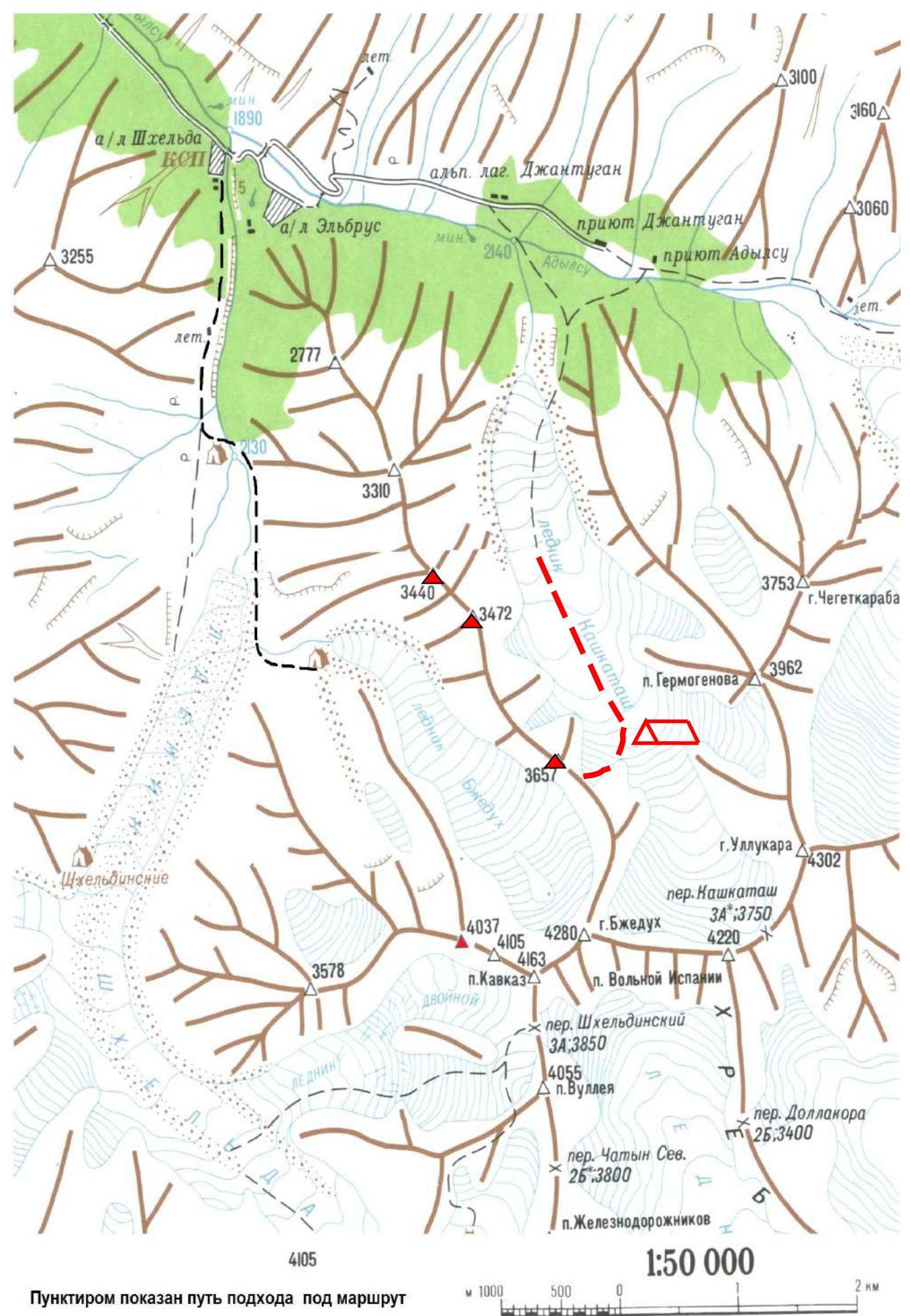
The object of the ascent: traverse of peaks 3657–3472–3440 (first ascent), located in the northern spur of peak Bzhedukh (Gybaynu ridge). From the Kashkatash glacier, the ascent to the Gybaynu ridge starts from overnight stays near the "red rocks" via a snow-rock couloir, leading to a saddle.
From the saddle:
- Going left is the classic path of the Distel route, 3B cat. diff., to peak Bzhedukh.
- Going right is the new route: traverse of peaks 3657–3472–3440, preliminarily assessed as 3A cat. diff. The route is rocky, ridge-like, long, safe, and educational, with diverse belaying opportunities, including several rappels and abseils.
The first peak, 3657 m, is rocky and heavily eroded. The ridge between peaks 3657 and 3472 becomes more monolithic, with steep slopes. The peak 3472 m (Novorossiysk peak) is monolithic, represented by a 10-meter vertical rock block. Further, to the saddle between peaks 3472 and 3440, the ridge is steep and monolithic. The third peak, 3440 m, is composed of large rock blocks and features rich terrain. Near the peak, there are bivouac sites, hence the name Bivachnaya. No human presence was detected on the peaks of this traverse. The ascent from the bivouac near the "red rocks" to peak Bivachnaya (3440 m) takes 12 hours. The descent to the Kashkatash glacier takes 3 hours, and another 1 hour to the overnight stays.
The key to the ascent is passing sections R3–R6.
1.1. General Photo
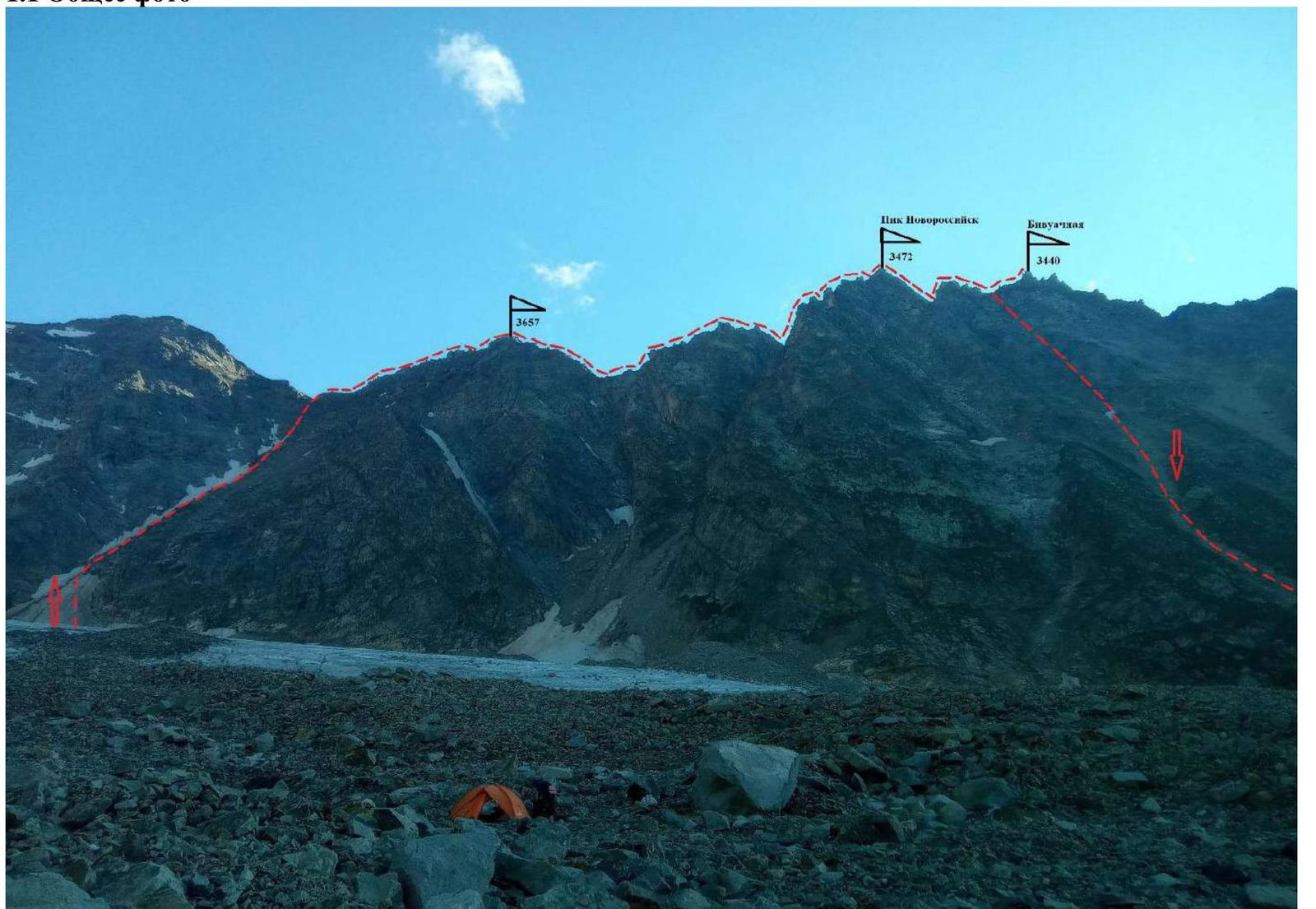
Photo 1. A. Korolev's route, traverse 3657–3472–3440, 3A cat. diff. Date taken: July 27, 2022
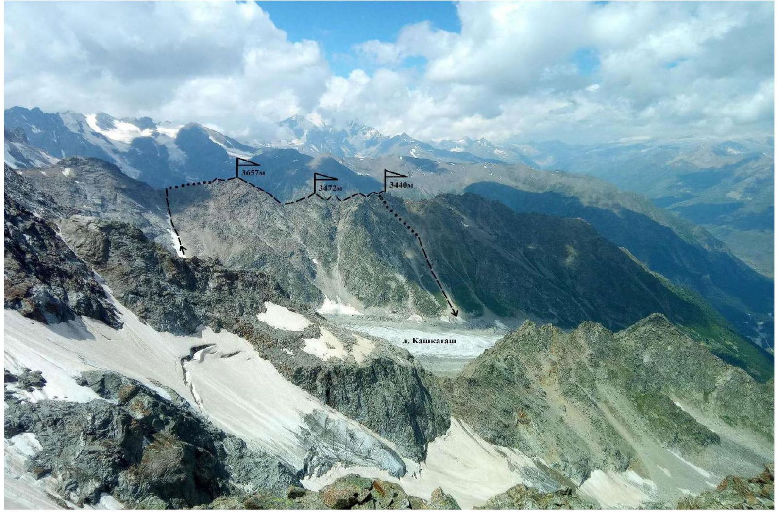
Photo 2. View from the slope of Chegetkara. Date taken: August 15, 2022
1.2. Route Profile
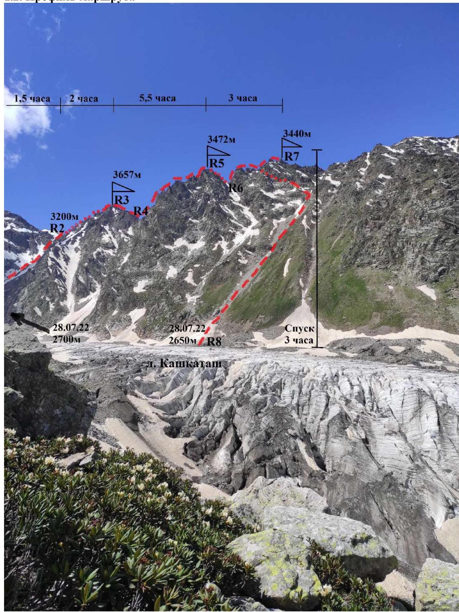
Photo 3. View from the Kashkatash valley. Date taken: July 17, 2022
1.3. Photopanorama of the Area
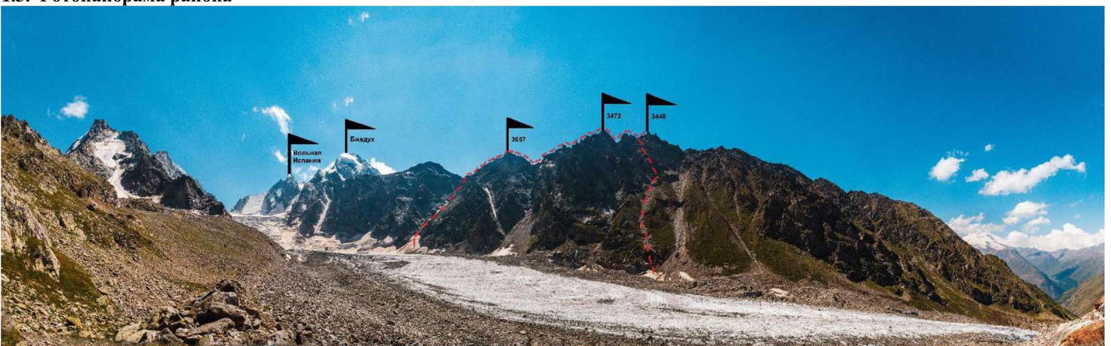
Photo 4. View from the Kashkatash valley. Date taken: July 17, 2022
Map-scheme of the ascent area
1.4. Geographical Location of the Area
The ascent object is located in the Kashkatash valley. The initial bivouac is near the standard overnight stays at the "red rocks" on the right-bank moraine of the Kashkatash glacier. The approach from the Baksan valley (Elbrus village) follows the highway up the Adylsu river to the Jantugan alplager (7 km). Then, cross the bridge to the left bank of the Adylsu river and ascend through the Koshey glade into the Kashkatash valley. The trail leads to the right-bank moraine. On it, near the "red rocks," are old overnight stays, 3 hours from the Jantugan alplager.
2. Characteristics of the Route
2.1. Technical Photograph of the Route
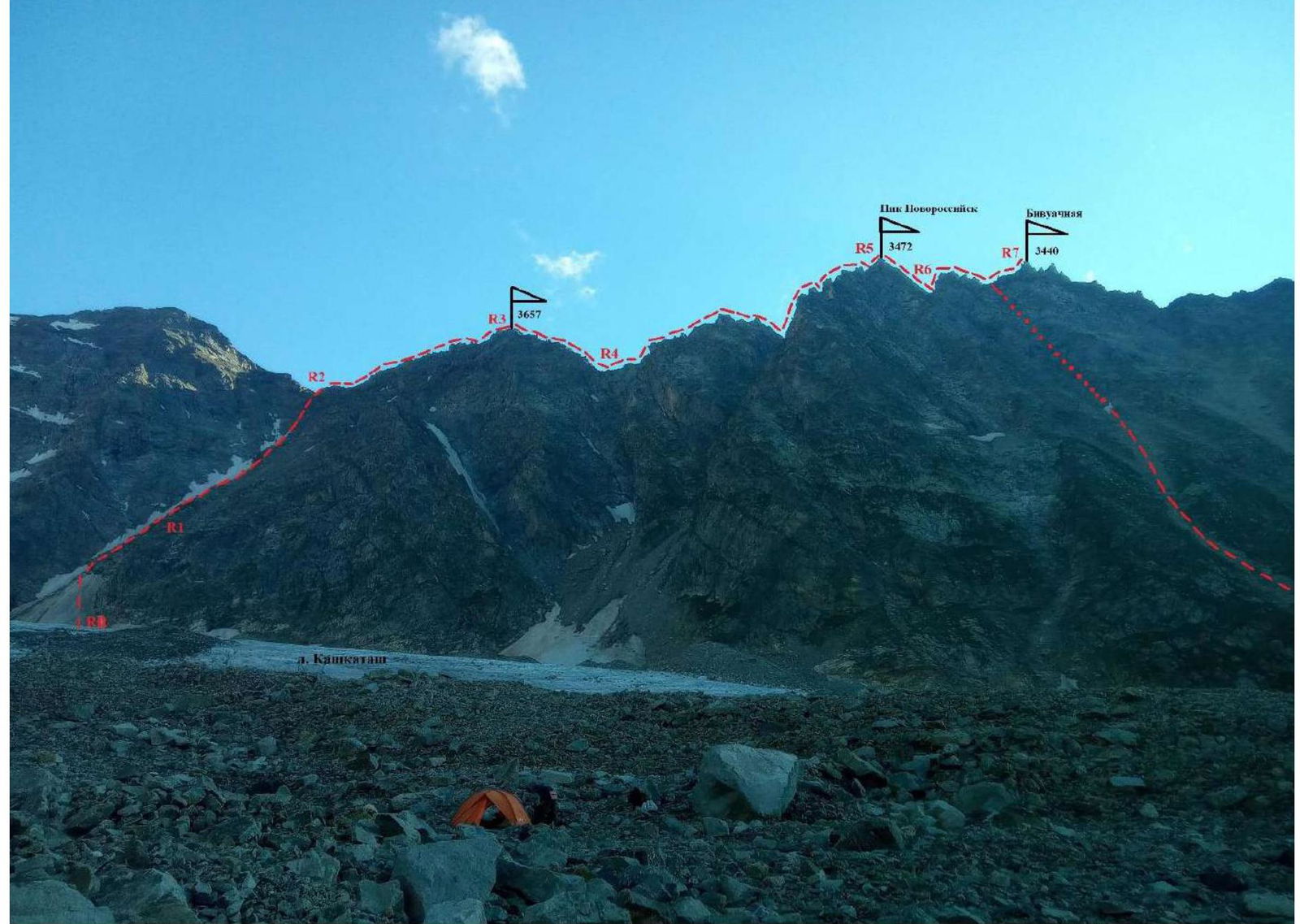
Photo 5. View from})
2.2. Technical Characteristics of Route Sections
| № section | Terrain | Category of difficulty | Length, m | Type and number of hooks |
|---|---|---|---|---|
| From overnight stays to the base of the snow couloir | Movement with crampons | |||
| R0–R1 | Lower part of the couloir is snowy (firn) | 1 | 200 m 30° | Movement in a rope team |
| R1–R2 | From the snow couloir, exit to its right side and via destroyed rocks, exit to the Gybaynu ridge saddle | 2 | 600 m 45° | Loop 3 pcs, chock 3 pcs |
| R2–R3 | From the saddle, move right onto the ridge of peak 3657 m. Via simple rocks, bypassing the belay on the right, reach peak 3657 m. No cairn; we build our own. | 1–2 | 1000 m 35° | |
| R3–R4 | From the peak, descend towards the main ridge saddle. Bypass the belay on the right via a shelf. Then, two 50 m rappels to the saddle. | 2, 3 | 350 m 40°, 150 m 50–60° | Chock 3 pcs, Loop 3 pcs. |
| R4–R5 | From the saddle, ascend to the ridge. Steep belays are bypassed on the right via shelves. Then, 2 50 m rappels lead to the second rocky saddle on the ridge. Further, a relatively simple ridge leads to peak 3472 m. No cairn on the peak; we build our own and name it Novorossiysk peak | 2–3, 2 | 1500 m 45°, 500 m 35° | Chock 4 pcs, Loop 4 pcs, Loop 2 pcs. |
| R5–R6 | From peak 3472 m, descend left via an internal corner — 1 rappel. Belays on the ridge are bypassed on the left. Reach saddle R6. | 3 | 200 m 45° | Chock 2 pcs, Loop 2 pcs. |
| R6–R7 | From saddle R6, via a steep wall on its right side, exit to the broad ridge of the third peak. The summit ascent is via shelves on the right. No cairn on the peak; we build our own. The peak is named Bivachnaya due to nearby bivouac sites. | 3, 1–2 | 100 m 60°, 600 m 30° | Chock 2 pcs, Loop 2 pcs. |
| R7–R8 | Descent: from the peak, descend via the familiar ridge back — 200 m. Then, descend the slopes into the Kashkatash glacier valley. On steep sections, 3 50 m rappels were made, descending to destroyed rocks and scree. The scree leads to a grassy-scree couloir and then to the Kashkatash glacier. | 3–2–1 | 150 m 60°, 200 m 30–40°, 600 m 40 r.p. | Chock 3 pcs, Loop 3 pcs. |
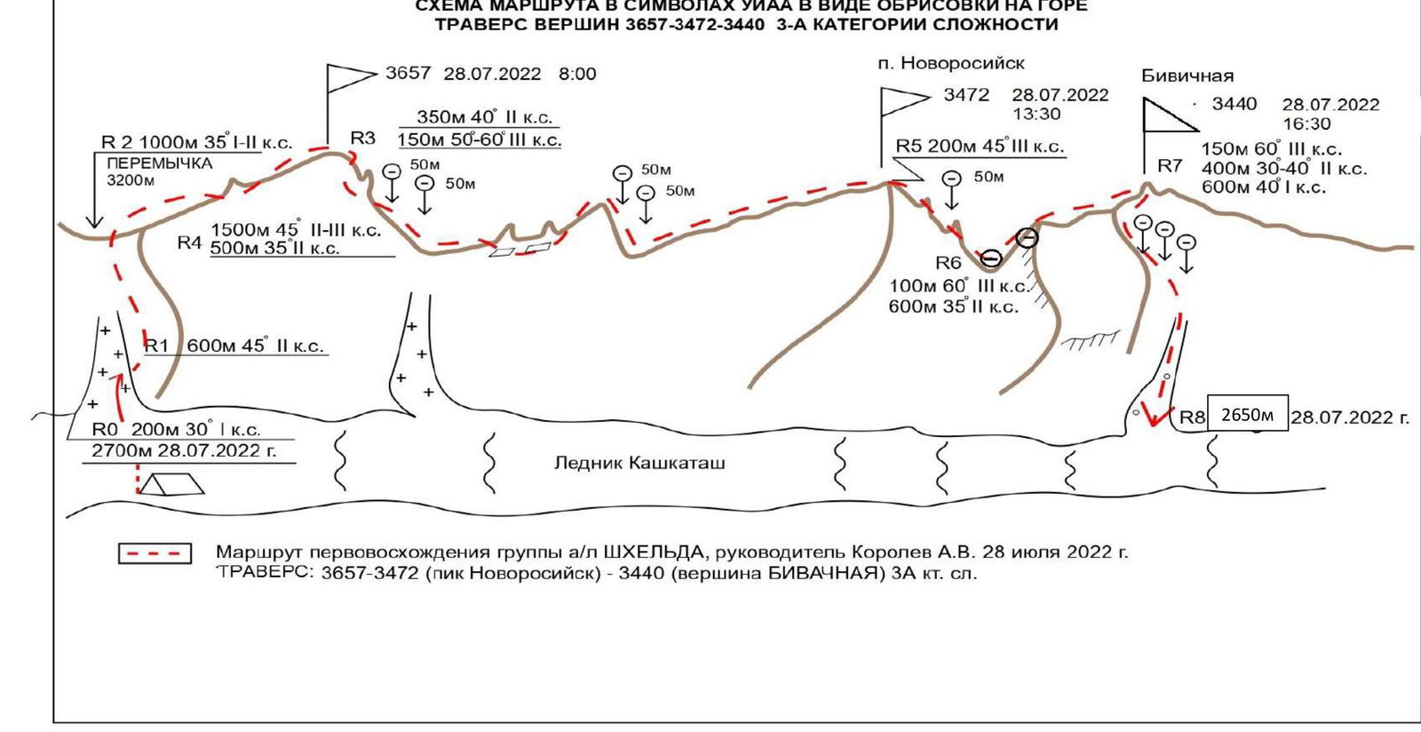
Route of the first ascent by the SHKhelda alplager group, leader Korolev A.V., July 28, 2022. TRAVERSE: 3657–3472 (Novorossiysk peak) — 3440 (BIVACHNAYA peak) 3A cat. diff.
3. Characteristics of the Team's Actions
The team, departing at 4:30 from the bivouac on the Kashkatash glacier, reached the first peak at 8:00. Movement was simultaneous in a rope team. The initial movement was through a snowy couloir, followed by simple rocks of 1–2 categories of difficulty. On the ridge section between peaks 3657 m and 3472 m, there are two rocky saddles, each requiring 2 50 m rappels. The steepness is around 60 °. The rocks are monolithic, mostly 3rd category of difficulty. Passing the ridge from peak 3657 m to 3472 m takes 5 hours and 30 minutes. On the descent from peak 3472 m, one 50 m rappel is necessary. From the saddle between the second and third peaks, a steep 100-meter wall leads to a simple ridge to peak 3440 m, which has bivouac sites. The transition from peak 3472 m to 3440 m takes 3 hours. The key section of the ascent is R3–R6. To descend from peak 3440 m, return along the ridge for 150–200 m and begin the descent to the Kashkatash glacier. From the ridge, 3 50 m rappels lead to a rocky-scree couloir, which exits to the lower part of the Kashkatash glacier. The descent takes 3 hours. From the descent point to the storm camp is 1 hour's walk. From the traverse ridge, communication with the SHKhelda alplager is stable. On the traverse route, the primary belay elements were chocks and loops. The route is ridge-like and logical. The route, in terms of technical difficulty and length, surpasses the Irikchat traverse (3B) and is classified as 3A cat. diff.
| № section | Description | № photo |
|---|---|---|
| Terrain characteristics are reflected in the previous table. The entire route is in rope teams. The route is ridge-like and logical | ||
| R3 | Team members on peak 3657 m | №6 |
| R4–R7 | View of the traverse section from R4 to R7 | №7 |
| R3–R4 | First rappel from peak 3657 m | №8 |
| R3–R4 | Second rappel from peak 3657 m towards the first saddle | №9 |
| R3–R4 | View of peak 3657 m from the southwest ridge of peak 3472 m | №10 |
| R4–R5 | Rocky terrain character when approaching peak 3472 m (Novorossiysk peak) | №11 |
| R5–R6 | Descent from Novorossiysk peak | №12 |
| R5–R6 | Station on the descent from Novorossiysk peak | №13 |
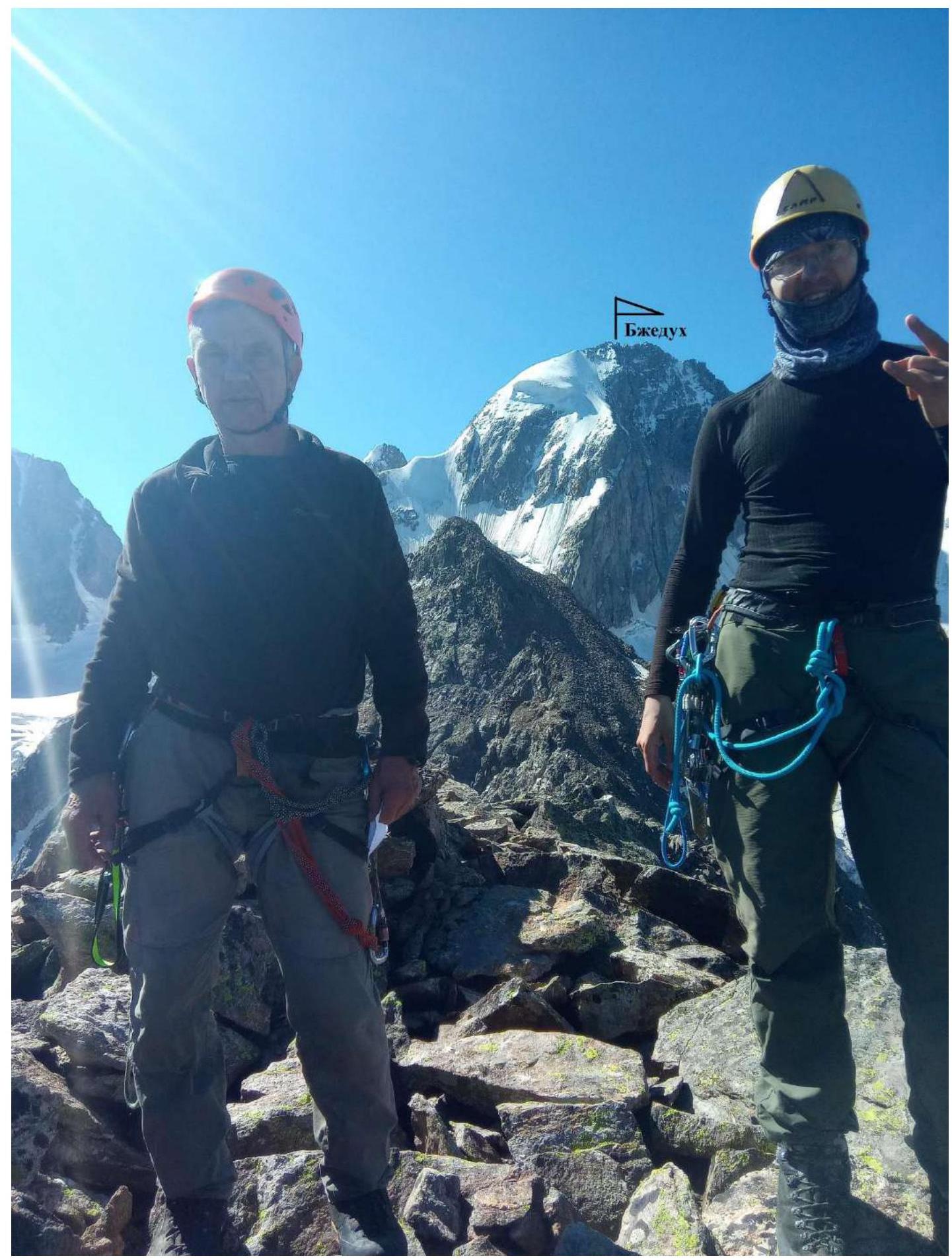
Photo 6. View from peak 3657 to Bzhedukh. Section R3
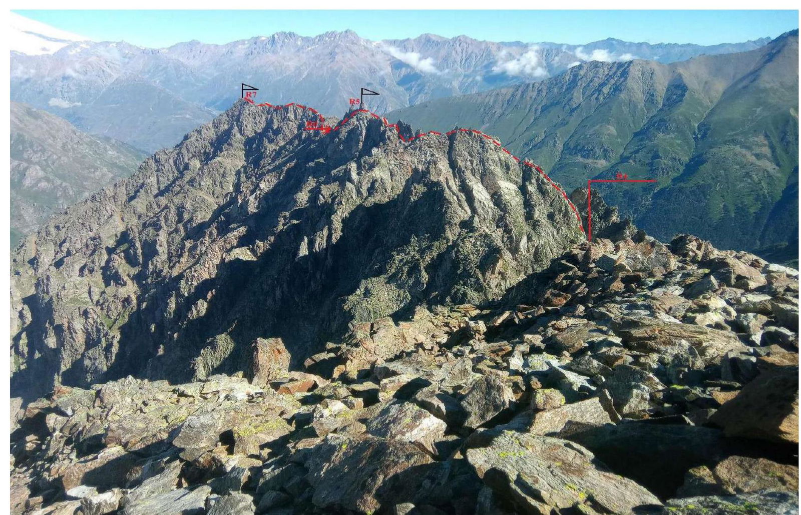
Photo 7. View from peak 3657

Photo 8. First rappel from peak 3657. Section R3–R4
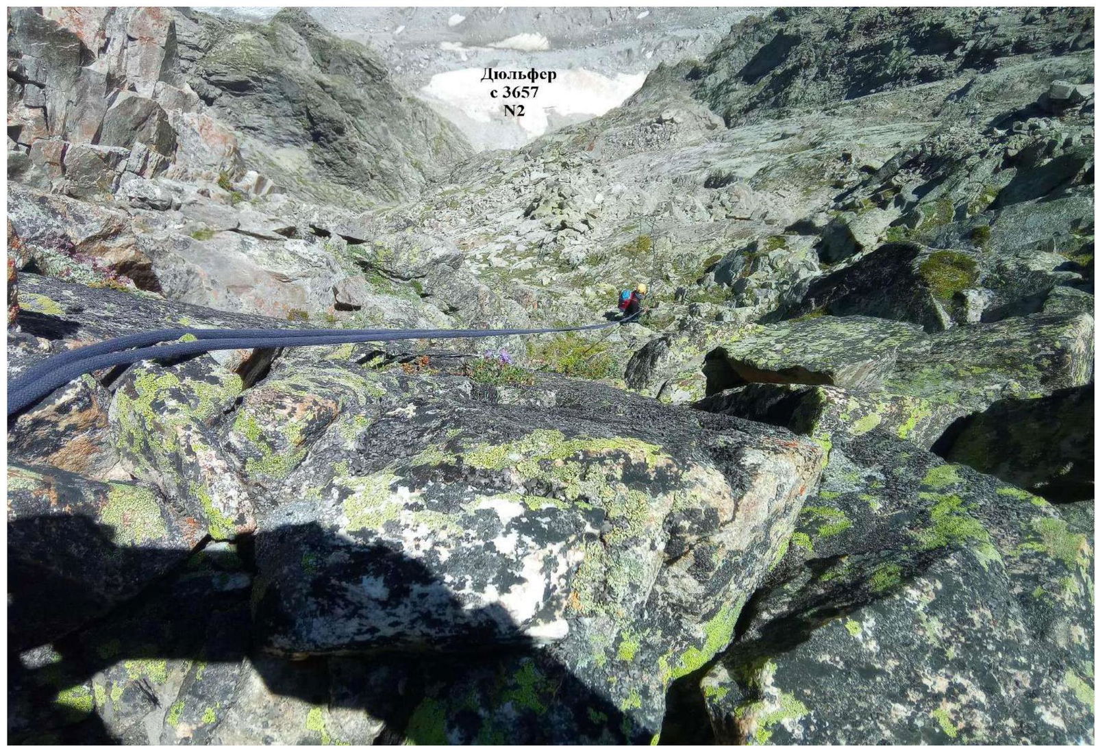
Photo 9. Second rappel from peak 3657. Section R3–R4
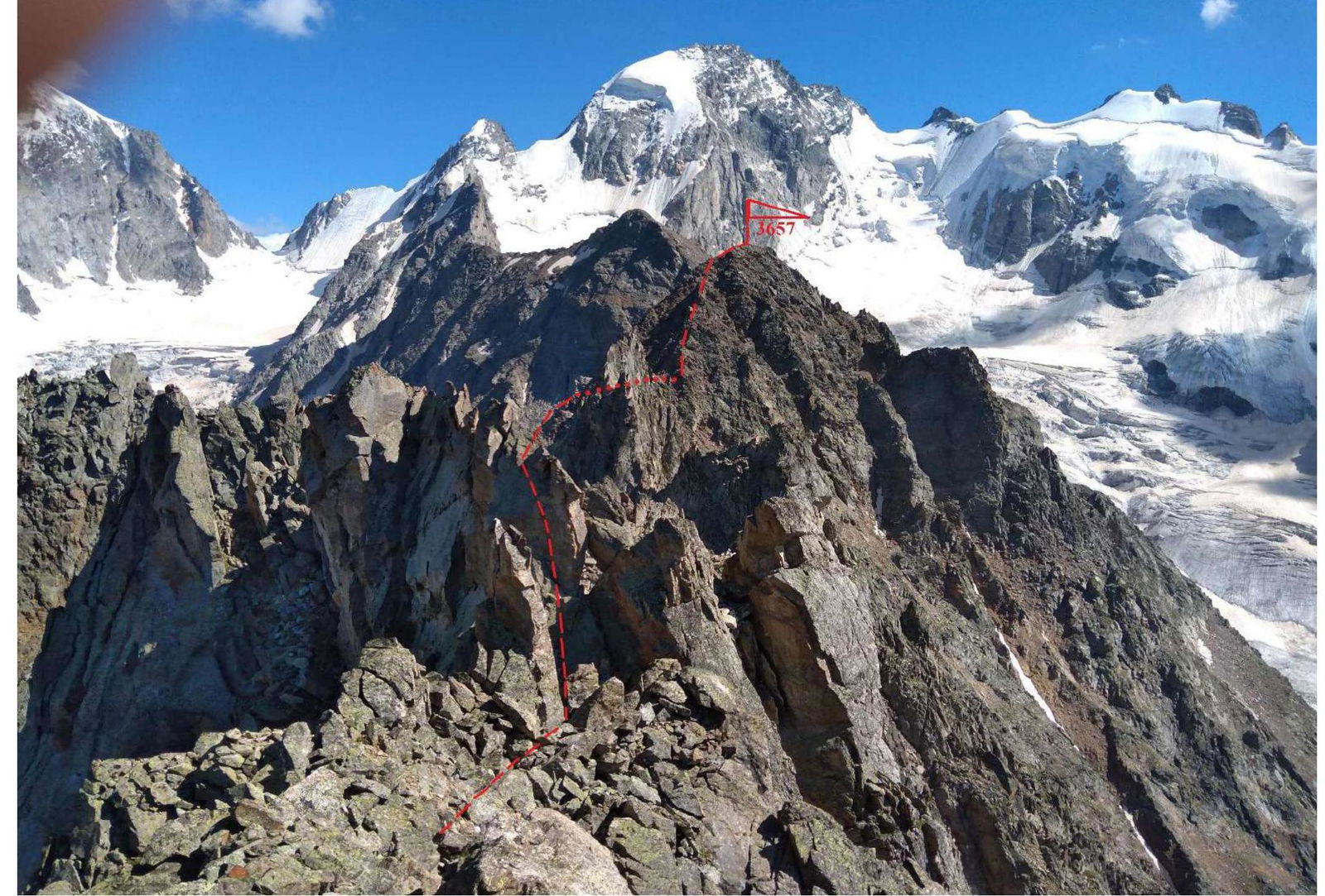
Photo 10. View of peak 3657 from the slopes of p. 3472. Section R3–R4
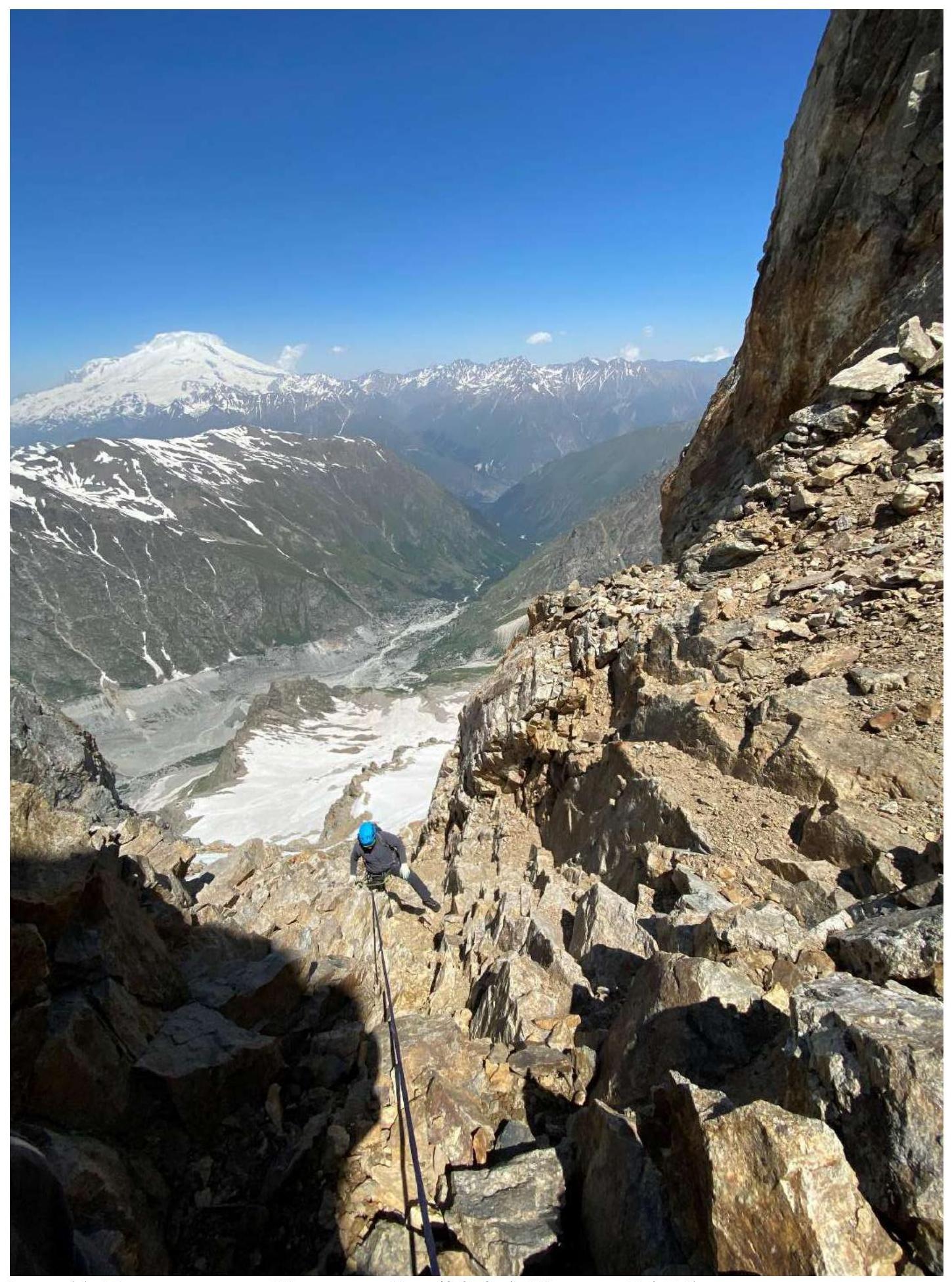
Photo 11. Ascent to Novorossiysk peak (3472 m). Section R4–R5
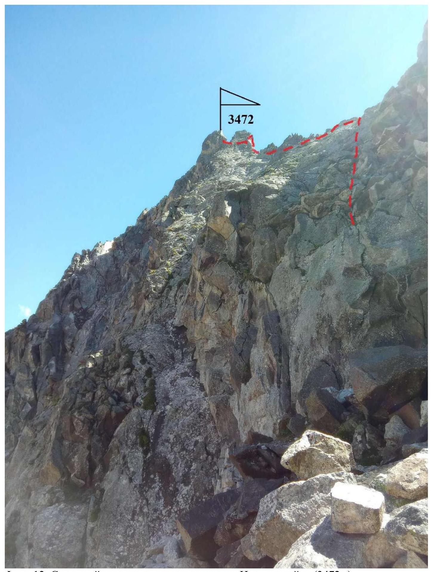
Photo 12. Rocky section when approaching Novorossiysk peak (3472 m). Section R4–R5

Photo 13. Descent from Novorossiysk peak (3472 m). Section R5–R6
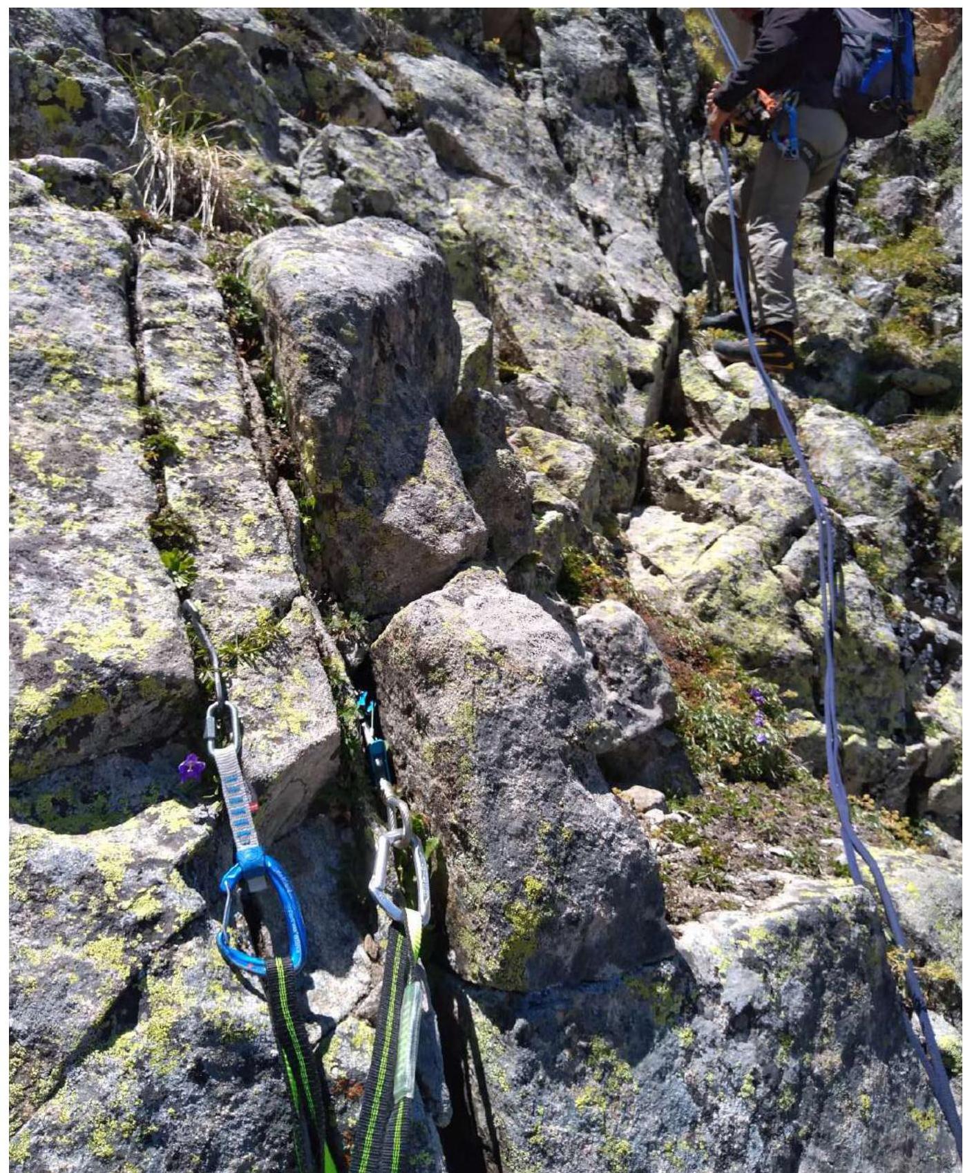
Photo 14. Rappelling descent from Novorossiysk peak (3472 m). Section R5–R6