
ELBRUS EASTERN AND WESTERN PEAKS TRAVERSE VIA THE SOUTHERN SLOPE 3–4 cat. dif.
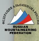
From the village of Terskol, ascend via the road on the left bank of the Terskol River. The road almost immediately crosses to the left side of the southeastern spur of the Elbrus massif into the Azau gorge and gradually ascends to the "95" checkpoint, then to the "105" checkpoint and further to the ice base. The road serpentines can be bypassed via trails in many places, starting from the transformer booth near the village of Terskol. From the village of Terskol, 5–6 hours.
From the ice base, descend from the moraine onto the glacier, then make a steep ascent. Continue upwards along the gentle snowy slope, gradually bearing left, moving in a broad snowy hollow until the slope steepness increases sharply (to 30–35°). Here, turn left and, ascending via a traverse onto a snowy rise, after 300–350 m, reach the rocky ridge where the Priyut 11 ( Refuge of Eleven) is located (to the left of the ascent path — hidden crevices). From the ice base, 1.5–2 hours. In summer, the path from the ice base to Priyut 11 is usually marked with wooden stakes every 40–60 m.
Another ascent option to Priyut 11 is possible: from Terskol by car to Azau, then via the cable car and from the cable car station upwards along the broken rocks and snowfields — from the station, about 3–3.5 hours.
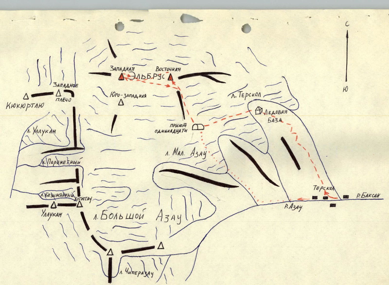
At Priyut 11, it is advisable to have an active acclimatization day with an exit to the Pastukhov rocks.
From Priyut 11 (departure at 1–2 am), ascend directly upwards, left of the heavily snowed rocky ridge, in the direction of the Eastern peak, to the left side of the small rocky outcrops known as the Pastukhov rocks. From the Pastukhov rocks: 300–400 m, direct ascent straight up, oriented towards the rocky outcrops on the southern slope of the Eastern peak. Along them, straight up (1st control cairn) and after 1.5–2 hours of simultaneous movement, reach the cairn on the Eastern peak. From Priyut 11 — 5–5.5 hours. From the cairn — westwards to the right peak plateau. Along the gentle rocky outcrops and then along the snowy slope down to the saddle (30–35 minutes).
100–150 m before reaching the hut, begin the ascent along the eastern moraine slope of the Western peak. In the upper part of the slope, hard firn is possible (insurance). After reaching the shoulder, move along the broad peak plateau northwestwards and then, after a short rise, to the peak. From the saddle — 1.5–2 hours.
Descent from the peak plateau is possible either via the ascent route or slightly leftwards along the gentle snowy slopes to the saddle (1 hour) and then from the hut leftwards downwards to the starting point of the ascent to the Eastern peak. From the saddle to Priyut 11, 2–3 hours. From Priyut 11 to Terskol, 3–3.5 hours.
Route duration — 3–4 days.
Equipment required for a group of 4:
- Main rope .................... 1×40 m.
- Rock pitons .................... 2 pcs.
- Ice screws .................... 1 pcs.
- Hammer or ice axe ............ 1 pcs.
- Carabiners ...................... 2 pcs.
- Crampons ....................... 1 pair.
 www.alpfederation.ru ↗
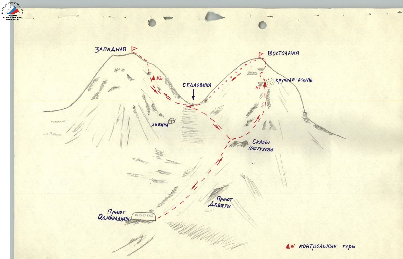 www.alpfederation.ru ↗
ASCENT DOCUMENTATION
- Type of ascent: ice and snow climb.
- Region of ascent: 2.4 from Chiperaza Pass to Kitlod Pass.
- Elbrus from the north via the "KREST" route: saddle 5350 m, Eastern peak 5621 m, Western peak 5642 m. The route passes from the north between the icefalls directly to the saddle, from the saddle from the hut directly up to the Western and Eastern peaks, descent to the south to "Priyut 11" and further to Azau.
- Estimated category of difficulty — 4A.
- Route characteristics: height difference from "Priyut Semeryokh" 2021 m — 2042 m. Average steepness 40°. Length of sections: R1 — 1000 m, R2 — 500–600 m, R3 — 500–600 m, R4 — 300 m, R5 — 200 m, R6 — 300 m, R7 — 600–700 m, R8 — about 1000 m, R9 — 300 m, R10 — 600–700 m.
- Number of ice screws used for insurance — 16 pcs.
- Number of walking hours from "Priyut Semeryokh" to "Mir" station — 23 hours.
- Number of nights: I — at an altitude of 5000 m on ice, II — on the saddle near the hut on snow — 5350 m.
- Leader: Ruslan A. Gorda, Master of Sports of the USSR in mountaineering. Participants: Viktor A. Gosman — 1st sports category in mountaineering. Nina A. Shalygina — 1st sports category in mountaineering. Vitaly P. Fedorstov — 2nd sports category, achieved in the current year. Boris V. Fedorov — 2nd sports category, achieved in the current year. Nikolai S. Kuderkin — 2nd sports category, achieved in the current year. Alexander Yu. Yankov — 2nd sports category, achieved in the current season.
- Coach — Ruslan A. Gorda.
- The group started the route on September 2, 1977, and returned on September 5, 1977.
Report
Description of the "KREST" route on Elbrus from north to south.
On August 31, 1977, the group departed from Kislovodsk. From Kislovodsk to the Dzhily-Su tract, 85 km — 5 hours by GAZ-66 vehicle. The vehicle delivers to the base camp if the road is in good condition; otherwise, an additional 5 hours are required on foot. We arrived at the base camp in the dark.
On September 1, 1977, we observed Elbrus, examined the chosen route through binoculars, and scouted the approach paths.
The Dzhily-Su tract has:
- two hot narzan springs with large natural baths.
The nature of the tract is very beautiful.
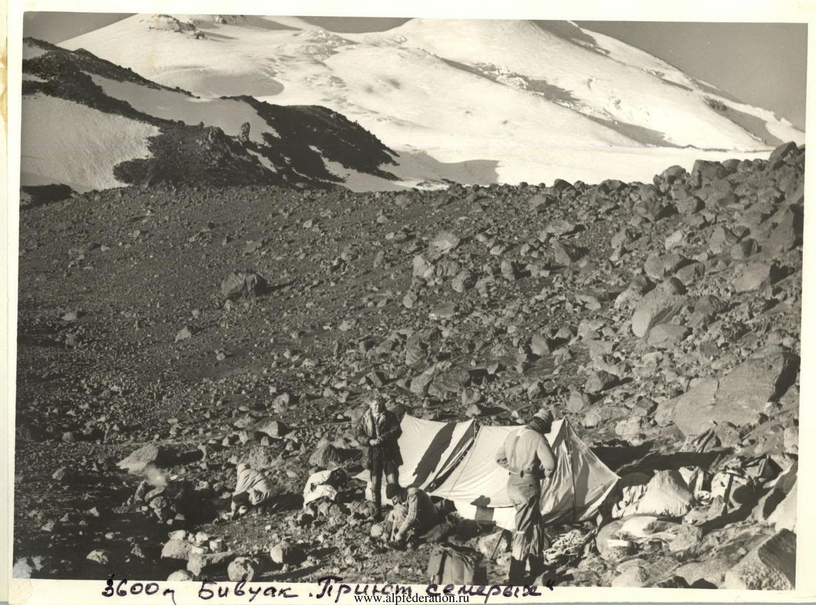
On September 2, 1977, the group departed from the base camp at 6:00. Slightly downstream, we crossed the Kyzyl-Su River to the right (orographic) bank and continued along the river upstream to a large plateau known as the "aerodrome" — 3 hours of walking. The "aerodrome" is crossed diagonally from right to left towards the Kara-gul glacier (black moraine). Before reaching the moraine, it is necessary to start ascending leftwards up the steep grassy slope. The average slope steepness is 40–45°. This slope leads to a high-altitude plateau behind the right (orographic) lateral moraine of the Kara-gul glacier. The ascent takes 3–3.5 hours. The plateau is quite vast and is separated from the Elbrus glaciers by a high moraine. Along the lateral moraine, a stream flows, and grass and flowers grow along its banks. Between the stream and the moraine, there is black-colored fine sand. The plateau height is 3600 m.
Here, a bivouac was set up, which was named "Priyut Semeryokh" (Refuge of Seven). At night, the stream freezes to the bottom, but with sunrise, it comes to life. September 3, 1977.
From the "Priyut Semeryokh" bivouac to the start of the route, it takes 1 hour to walk. It is necessary to exit through the moraine onto the Kara-gul glacier and move along its right bank upstream, bypassing the moraine. The exit onto the Elbrus glacier plateau is calm and safe. The ascent steepness is 25–30°. Section R1. At the beginning of the glacier plateau, it is necessary to rope up!
The "KREST" route passes between two icefalls, to the right of the long icefall when viewed from Elbrus, and leads directly to the saddle. From the saddle, there is an exit to the Western and then to the Eastern peak, followed by a descent to the south to "Priyut 11".
From the beginning of the Elbrus glacier plateau, move in ropes, observing all necessary safety precautions when moving on a closed glacier — on a full rope! Initially, move to the right along the even (10–20°) closed glacier for 30 minutes, entering a broad ice mulde. From the mulde (section R2), the route goes to the right along the ice-snow slope under the end of the long icefall — 1 hour (section R3). The ascent steepness is 35–40°. The exit under the icefall crosses a zone of closed crevices, which are well-probed. Put on crampons!
The exit to the right side, along the path, of the long icefall passes with the overcoming of an ice dome (section R4) with an average steepness of 45–50° and a length of 250–300 m. From this section, the route passes along purely ice slopes. When exiting onto the dome, the steepness of the ice slope increases to 55° and in some places (30–40 m) to 60°. Movement is on crampons with alternate insurance through ice screws. The steepest section is overcome on the front teeth of crampons.
Further, 200 m of the route goes to the right (along the path) of the long icefall along an ice slope with a steepness of 30–35° (section R5). This section is cut by long and wide crevices, which are bypassed. After this section, 300 m of the route has an increased steepness (section R6) and transitions into an ice rise with a steepness of 45–50° and a length of 600–700 m (section R7), which is traversed on crampons with alternate piton insurance.
After the rise, the slope becomes gentler, reaching 35–40° over a length of 800–1000 m (section R8), and leads to a plateau under the upper icefalls. When exiting onto the plateau, there are crevices! (Attention!) The plateau height is 5000 m. This is the only safe place for a bivouac along the entire route. Bivouac!
We reached the plateau at 18:00. Total work for the day: 12 hours. The ascent from "Priyut Semeryokh" was 1400 m. We worked on crampons for 9.5 hours. Further movement to the saddle can be done without crampons.
On September 4, 1977, from the bivouac to the saddle, crampons are not needed since the ice is covered with snow. 100 m from the bivouac towards the saddle, a wide icefall begins, or rather, long transverse crevices. Move directly upwards. The first 300 m (section R9) have a steepness of 35–40°. The icefall is covered with powdery snow. It is necessary to move on a full rope with thorough probing of the path. Further, the slope becomes gentler, reaching 25–30° (section R10) over a length of 600–700 m. In addition to open crevices, there are many closed ones. Movement is in single file. Crevices are bypassed. Often, there are wide depressions filled with loose snow, where it is necessary to dig a trench, sinking up to the waist. The passage through this icefall took 6 hours. 200 m before the saddle, crevices disappear, and the snow becomes denser. Walking becomes pleasant, but the altitude is strongly felt. The pace of movement slows down significantly. The saddle height is 5300 m. The ascent from the bivouac to the saddle took 6.5 hours. The height gain was 350 m.
Near the hut, we set up tents, had lunch, and directly from the hut, began the ascent to the Western peak, initially to the right of the rocky ridge and then along the rocky ridge.
The ascent can be done without crampons but in ropes. Crampons are necessary for the descent since the slope is steep.
Ascent and descent times:
- Ascent to the Western peak took 1.5 hours.
- We were at the peak at 17:00.
- Descent took 1 hour.
The descent along the steep firn on crampons was conducted quickly and clearly. We spent the night on the saddle near the ruined hut.
On September 5, 1977, the night was very cold. From early morning, the weather started to deteriorate. The ascent to the Eastern peak was made directly upwards from the hut. The ascent took 1 hour, and the descent took 30 minutes. The ascents from the saddle to the peaks were made, like yesterday, without backpacks.
After descending from the Eastern peak, we quickly packed up the bivouac and began the descent to the south to "Priyut 11" via the usual path. The descent from the saddle to "Priyut 11" took 2 hours. The well-being of all participants was excellent.
On the same day, at 17:00, we were at the K:
The route is interesting, complex, and impressive. It requires excellent ice and snow climbing skills.
The traversed route can be compared only to an ice and snow route. Such a route can be the Bzheduk ascent with category 3B, considered classic. Without considering the altitude, the "KREST" route on Elbrus significantly surpasses the well-known Bzheduk ascent 3B in technical difficulties, not only in the length of ice slopes but also in their steepness.
Therefore, the group requests to classify the "KREST" route on Elbrus from north to south as category 4A.
Group Leader R. Gorda

| Date | Designation | Average steepness | Length in meters | Relief characteristics | Difficulty | State | Weather conditions | Pitons (ice screws) |
|---|---|---|---|---|---|---|---|---|
| 3 September 1977 | R1 | 25–30 | about 1000 | Ice slope | 2A | Ice is covered with a thin layer of snow, no crevices. | good | Simultaneous movement |
| 3 September 1977 | R2 | 10–20 | 500–600 | Ice slope | 1B | Ice is covered with a thin layer of snow, crevices possible. | good | " |
| 3 September 1977 | R3 | 35–40 | 500–600 | Ice slope | 3B–4A | Steep ice slope covered with a thin layer of snow. | good | " |
| " | R4 | 45–50 | 250–300 | Very steep ice slope, transition to dome. | 4B | Clean ice | overcast | 5 |
| " | R5 | 30–35 | 200 | Ice slope with crevices. | 3B–4A | Clean ice | light snowfall | Simultaneous movement |
| " | R6 | 35–40 | 300 | Ice slope | 4A | Clean ice | " | " |
| " | R7 | 45–50 | 600–700 | Ice slope | 4B | Clean ice | overcast | II |
| " | R8 | 35–40 | about 1000 | Ice slope | 4A | Clean ice | overcast, wind | Simultaneous movement |
| 4 September 1977 | R9 | 35–40 | 300 | Snow-ice slope | 3A | Ice is covered with powdery snow. | clear | " |
| 4 September 1977 | R10 | 25–30 | 600–700 | Snow-ice slope with many crevices, rarely open. | 2A | Ice is covered with loose snow, not compacted underfoot. | clear | " |
Comments
Sign in to leave a comment