Ascent Passport
-
Class — winter.
-
Central Caucasus.
-
Peak Shchurovsky, 4259 m, via the northeast wall (V. Abalakov's route).
-
Category of difficulty: 5B.
-
Height difference: 800 m, length – 1050 m.
Length of sections with category 6 difficulty — 220 m. Length of sections with category 5 difficulty — 780 m. Average steepness of the route — 68°. Average steepness of the main sections — 75°.
-
Number of pitons driven
| Rock | Nut | Ice | Bolt |
|---|---|---|---|
| 18 | 115 | 25 | 0 |
- Team's travel hours — 27, days — 3;
- Overnights — 2 on ledges, semi-reclined, 1 at the summit — good. All overnights in a tent.
Leader — Moiseev Alexander Anatolyevich, Master of Sports. Participants:
- Fedorchenko Roman Viktorovich, Candidate for Master of Sports
- Lobankov Vladislav Petrovich, 1st sports category
- Start of the route — February 22, 1998, summit — February 24, 1998, return to base — February 25, 1998.
- Organization — Rostov Regional Federation of Alpinism and Rock Climbing.
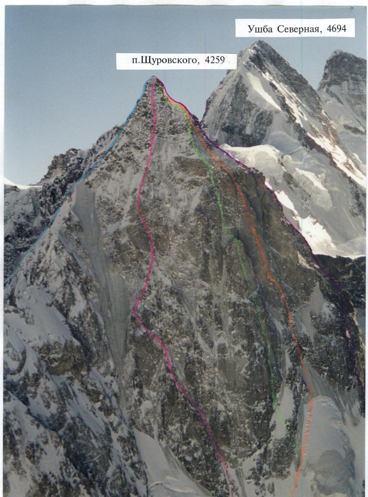
General photo of the summit of Peak Shchurovsky (4259 m), Olympus 120 camera, f=50 mm
- V. Pelevin via the NE ridge, 1947, 4B;
- V. Abalakov via the NE wall, 1953, 5B;
- L. Kensitsky via the N wall, 1962, 5B;
- M. Khergiani via the bastion of the N wall, 1962, 5B;
- V. Abalakov via the NW wall, 1947, 5A
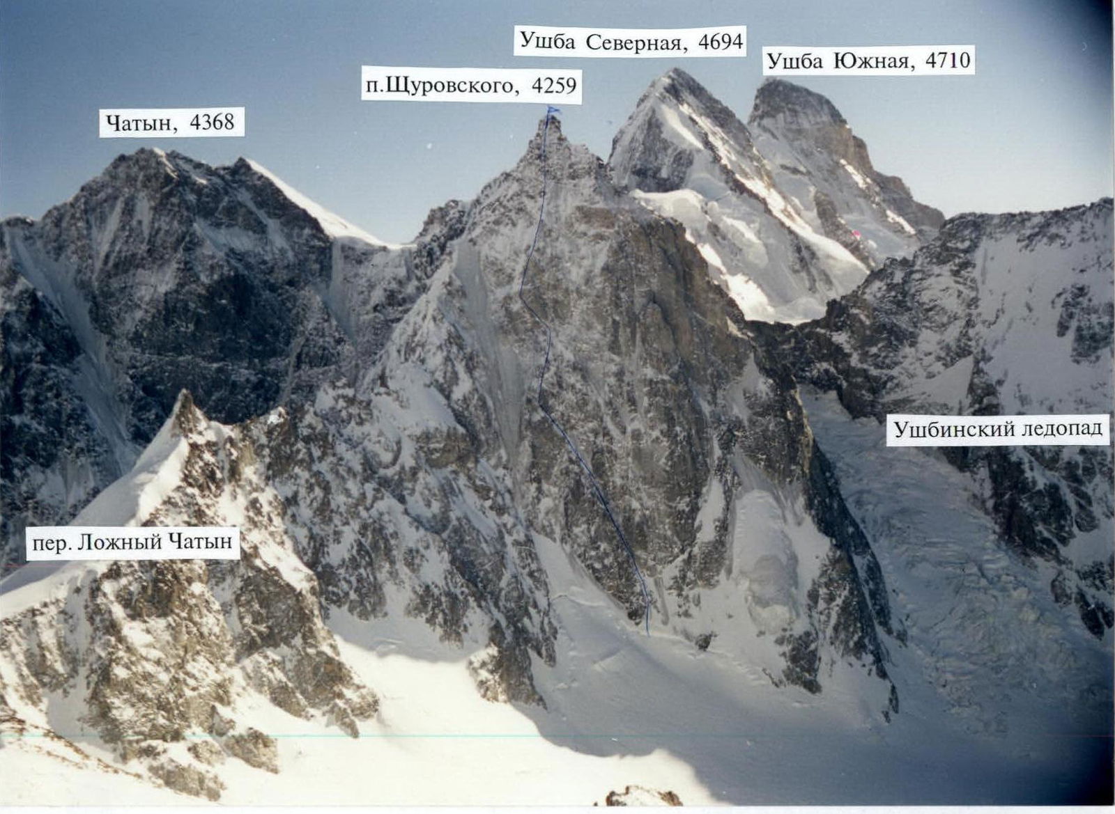
Photopanorama of the area. Olympus 120 camera, f=35 mm
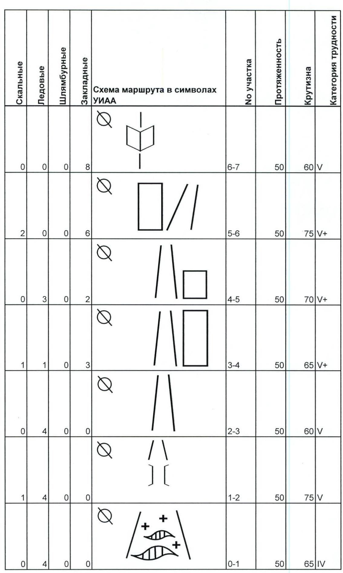
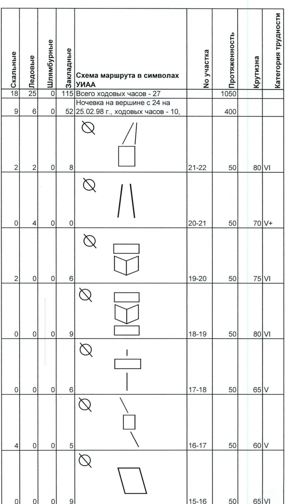
| Rock | Ice | Bolt | Nut | Route diagram in UIAA symbols / Notes | Section # | Length | Steepness | Category of difficulty |
|---|---|---|---|---|---|---|---|---|
| 0 | 4 | 0 | 0 | 0–1 | 50 | 65 | IV | |
| 1 | 4 | 0 | 0 | 1–2 | 50 | 75 | V | |
| 0 | 4 | 0 | 0 | 2–3 | 50 | 60 | V | |
| 1 | 1 | 0 | 3 | 3–4 | 50 | 65 | V+ | |
| 0 | 3 | 0 | 2 | 4–5 | 50 | 70 | V+ | |
| 2 | 0 | 0 | 6 | 5–6 | 50 | 75 | V+ | |
| 0 | 0 | 0 | 8 | 6–7 | 50 | 60 | V | |
| 2 | 1 | 0 | 5 | 7–8 | 50 | 60 | V | |
| 0 | 2 | 0 | 6 | 8–9 | 50 | 70 | V+ | |
| 0 | 0 | 0 | 8 | 9–10 | 50 | 70 | V+ | |
| 2 | 0 | 0 | 7 | 10–11 | 50 | 65 | V | |
| 0 | 0 | 0 | 8 | 11–12 | 50 | 60 | V | |
| 8 | 19 | 0 | 43 | Overnight from February 22 to 23, 1998, travel hours – 10. | 550 | |||
| 1 | 0 | 0 | 10 | 12–13 | 50 | 65 | V+ | |
| 0 | 0 | 0 | 10 | 13–14 | 50 | 80 | VI | |
| 1 | 0 | 0 | 9 |  | 14–15 | 50 | 70 | V+ |
| 1 | 0 | 0 | 20 | Overnight from February 23 to 24, 1998. Travel hours – 7, processing – 1 rope. | 100 | |||
| 0 | 0 | 0 | 9 | 15–16 | 50 | 65 | VI | |
| 4 | 0 | 0 | 5 | 16–17 | 50 | 60 | V | |
| 0 | 0 | 0 | 6 | 17–18 | 50 | 65 | V | |
| 0 | 0 | 0 | 9 | 18–19 | 50 | 80 | VI | |
| 2 | 0 | 0 | 6 | 19–20 | 50 | 75 | VI | |
| 0 | 4 | 0 | 0 | 20–21 | 50 | 70 | V+ | |
| 2 | 2 | 0 | 8 | 21–22 | 50 | 80 | VI | |
| 18 | 25 | 0 | 115 | Total travel hours – 27. | 1050 | |||
| 9 | 6 | 0 | 52 | Overnight at the summit from February 24 to 25, 1998, travel hours – 10. | 400 |
Description of the route by sections
| Section | Description |
|---|---|
| Section R0–R1 | Overhanging wall of the bergschrund. Steep ice gully. |
| Section R1–R3 | Steep ice gully. |
| Section R3–R4 | Exit from the gully to the right onto a steep rock wall. Rocks are covered with snow, making belaying difficult. |
| Section R4–R5 | Straight up the rock slabs, then left, through a gully onto a rock wall of a canyon-like couloir, up it; smooth slabs with few holds, covered with snow. |
| Section R5–R6 | Rock wall. |
| Section R6–R7 | Inner corner and exit onto a rock ridge. |
| Section R7–R8 | Rock ridge ends with a 15-meter ice gully. |
| Section R8–R9 | Long vertical chimney leading to snow-covered slabs. |
| Section R9–R10 | Along the slabs into an inner corner, leading to a "tooth," height 3750 m. |
| Section R10–R11 | From the "tooth" to the right, through a 15-meter wall onto a ridge. |
| Section R11–R12 | Rock ridge ends with a vertical wall, through it onto a snowy shoulder, where a "semi-reclined" overnight stay. Further through a wall onto a small ridge, covered with snow. |
| Section R12–R13 | Wall covered with frozen "live" rocks. |
| Section R13–R14 | Long inner corner. Movement along the right part. |
| Section R14–R15 | At the exit from the corner, on the left, a ledge. Overnight stay on it. Further straight up, along the right part of the ice gully. Steep rocks covered with snow. |
| Section R15–R16 | Slabs with few holds. |
| Section R16–R19 | Alternating walls and rock ridges, approach to the summit tower. |
| Section R19–R20 | Rocks covered with snow. |
| Section R20–R21 | Long ice gully. |
| Section R21–R22 | Overhanging rock wall, steep ice pitch leading to the summit. |

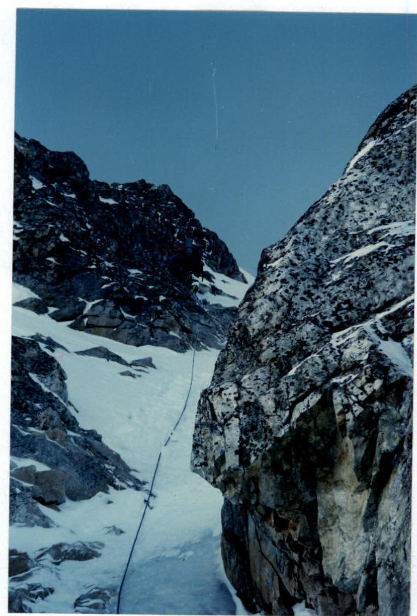
Section R2–R3, Olympus 120 camera, f=50 mm
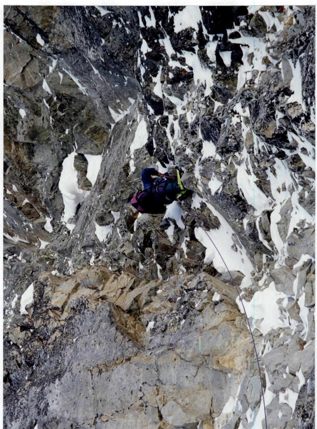
Section R8–R9, Olympus 120 camera, f=50 mm
Section R12–R13, Olympus 120 camera, f=50 mm


