
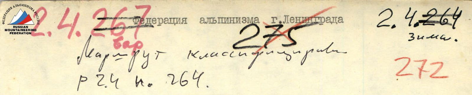
Report
on the ascent of the Leningrad Sports Committee team to Peak Shchurovsky via the Western wall "Surka" and the edge of the bastion of the Northern wall, category 5B (variant) Team captain — S.G. Kalmykov Team coach — A.I. Moshnikov
Central Caucasus January – February 1983
Brief geographical description and sporting characteristics of Peak Shchurovsky
Peak Shchurovsky is located in the Main Caucasian Range, which forms a complex zigzag in this area. The south-eastern ridge descends to the Western peak of Chatyn-Tau, and the north-eastern ridge descends to the Lожный Chatyn pass. To the south of the peak, reaching an altitude of 4100 m, is the famous Ushba plateau, descending along the western slopes of the peak with a grandiose Ushba icefall. The northern wall of the peak faces the Shkheldinsky glacier. On its kilometer-long slope, cut by snow and ice couloirs, the upper bastion stands out with a dark steep face, the right edge of which rests on the north-western counterfort, having a steep western wall.
The rocks of the bastion and the western wall "Surka" are characterized by their monolithic nature and smoothed relief, reminiscent of the relief:
- Western wall of South Ushba
- Northern wall of Chatyn
The area around Peak Shchurovsky and the peak itself, rising in the upper reaches of the Shkheldinsky glacier, are well-studied and developed by climbers, thanks to the close location of climbing camps and bases, and the availability of convenient communication routes. It is in this mountain hub that many top-class routes are found, known even beyond the country.
The first ascent of Peak Shchurovsky was made by S. Goluvev in 1915 from the Ushba plateau. More complex routes were laid here only after the war. The strongest team of its time, led by V. Abalakov, first climbed the north-western counterfort (1947), and then the north-eastern wall of the peak. The bastion of the northern wall was conquered only by M. Khergiani's group in 1962. Ukrainian climbers under the leadership of L. Kensitsky climbed the northern wall to the left of the bastion, and finally, in 1967, they conquered the steep western wall of the north-western counterfort. However, after the wall, they went further along Abalakov's 1947 route to the western ridge, not finding a better continuation. Now, all these routes have been repeatedly climbed by other groups, but no one has yet dared to attempt Peak Shchurovsky in winter.
Moreover, the shortest path along the north-western counterfort through the Western wall "Surka" and the edge of the bastion of the Northern wall remained unclassified to this day. This path attracted us with the possibility of combining the most complex steep faces of the peak into a single logical route. Solving this problem allowed us to take another step in the development of Peak Shchurovsky.
Conditions for winter ascents in the Central Caucasus
Characteristic features of winter ascents:
- Short daylight hours
- Low temperatures
- Increased snow cover on the terrain
Climbing conditions in the Central Caucasus are also characterized by extreme weather instability, especially in January-February. Therefore, experience with winter Asian ascents, typically conducted in more favorable conditions, should be used with extreme caution here.
The weather in this area can change rapidly, most often under the influence of warm fronts from Svaneti. Periods of bad weather are typically long-lasting. In our case, between January 16 and February 6, only 6 days were accompanied by good weather.
The air temperature in the upper reaches of the Shkheldinsky glacier ranged from −20…−25 °C (on clear mornings and evenings) to −10 °C (during daytime snowfalls).
The biggest nuisance was the strong wind with drifting snow, filling all the gaps in clothing and tents with snow, threatening frostbite to exposed body parts. Visibility during this time dropped to 20-30 m, and individual gusts of wind literally blew skiers off the slope. Strong winds of changing directions:
- did not allow snow to accumulate on steep slopes;
- contributed to the compaction of the snow cover.
In general, for the Caucasus, according to G.K. Tushinsky, "January and February are characterized by unstable weather, prolonged continuous cloudiness, and strong winds, but already in the last decade of February, the air temperature rises significantly during the day, so that snow compaction occurs even on northern slopes. In the highlands during this period, snowfalls are frequent, mainly in the form of dry snow... Finally, March is a long 13-14 hour day, frequent sunshine, rising temperatures (in the Caucasus, at night at an altitude of 3000 m not below 10-15 °C), weakening of winds..."
It follows that a more favorable period for ascents is March, but these ascents can be called winter ascents only conditionally. Thus, conducting ascents in the Central Caucasus in January-February is an independent sporting challenge.
The condition of the routes largely depends, as in summer, on the weather in the preceding days. At the same time, due to the increased snow cover, the complexity of rocky sections increases significantly. To a greater extent, this applies to sections with low and medium steepness. Slabs with a steepness of up to 50°, as a rule, are covered with flow ice, and gentle rocky ridges are so snow-covered that their relief almost completely disappears.
Firm sections of the routes with a steepness of 30° or more become icy. Working on hard winter ice places high demands on ice equipment and climbers' technique.
Steep and overhanging sections may look almost the same as in summer, but thin cracks and microrelief are clogged with ice and snow. This greatly complicates the use of pitons - cracks for them "disappear", thus the role of chocks increases sharply. In our ascent, chocks were used 5-10 times more often than pitons.
Complicating routes, reducing the reliability of free climbing, and, as a result, more frequent use of artificial technical means (ITM) leads to the fact that the duration of winter ascents is on average longer than in summer.
Avalanche danger in winter in the Caucasus is significant, but it should not be exaggerated; rockfall danger is much lower than in summer, which opens up additional opportunities and new routes even in such a well-developed area as the Central Caucasus.
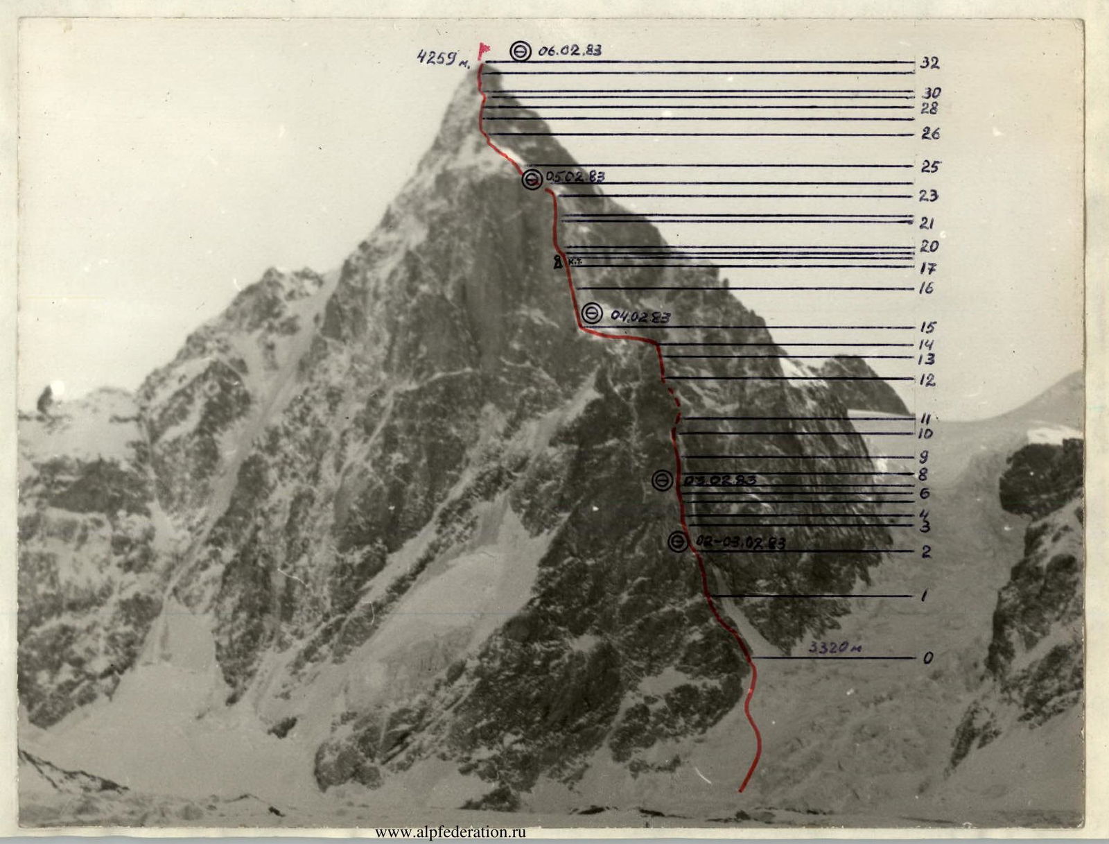
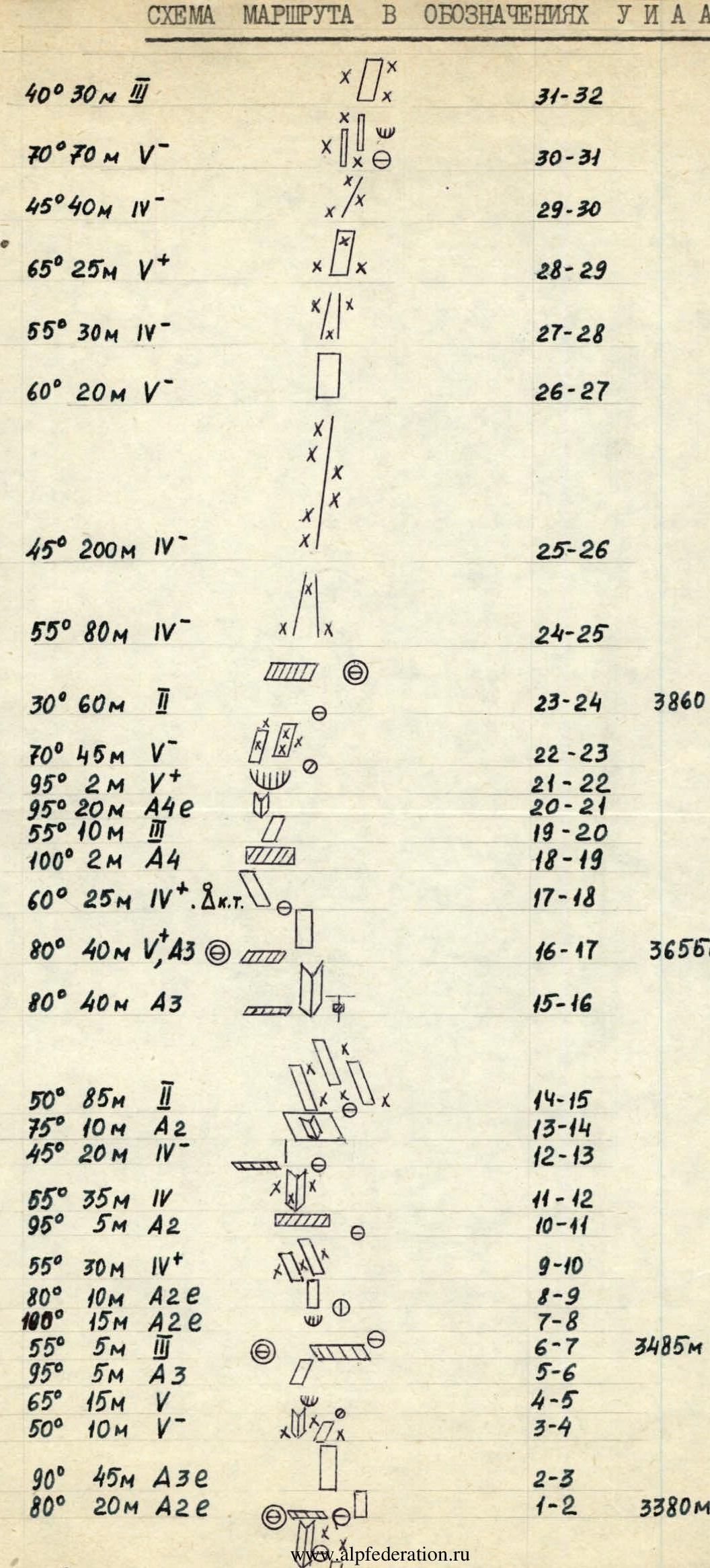
Table of main characteristics of the ascent route to Peak Shchurovsky via the Western wall "Surka" and the edge of the bastion of the Northern wall
Route length — 1129 m. Height difference — 939 m. Length of the most complex sections — 404 m. Steepness of the wall section — 70°, route — 60°.
| Section | Steepness, ° | Length, m | Terrain characteristics, difficulty | Cat. | Method of overcoming and belay | Conditions | Stop on biv., h. | Exit h. | Walking sk., h. | Chocks | Ice pitons | Bolts | Weather, temp., °C | Weight daily ration per 1 person |
|---|---|---|---|---|---|---|---|---|---|---|---|---|---|---|
| R0–R1 | 55 | 80 | Rocky terrain of medium difficulty, slabs, internal corners | IV | Free climbing, alternating belay | BL on "German" nights (Processing) | 14:00 | 2:30 | 5 | 12 | Snow, blizzard, wind, −15 °C | |||
| R1–R2 | 80 | 20 | Wall with small ledges | A2 | IT | -"- | -"- | 16:00 | 1:30 | 1 | 13 | From 12:00 – other's snow, blizzard | ||
| R2–R3 | 90 | 45 | Smooth wall | V, A3 | IT | -"- | -"- | 10:30 | 4:30 | 25 | Snow, blizzard, other's wind | |||
| R3–R4 | 50 | 10 | Smoothed slabs covered with snow | V | Free climbing | Lying on a shelf, before 1st "mirror" stage | 17:00 | 1:30 | 2 | Snow, windy, −15 °C | ||||
| R4–R5 | 65 | 15 | Internal corner | V | -"- | -"- | 3 | -"- | ||||||
| R5–R6 | 95 | 5 | Overhang with a crack | A3 | IT | -"- | 3 | -"- | ||||||
| R6–R7 | 55 | 5 | Slab, shelf | II | Free climbing, alternating belay | -"- | 1 | -"- | ||||||
| R7–R8 | 100 | 15 | Overhanging wall | V, A3 | IT | Lying on a shelf, before P st "mirror" | 17:00 | 6:30 | 2 | Fog, snow, −15 °C | ||||
| R8–R9 | 80 | 10 | Wall with small ledges | A3 | IT | -"- | 2 | -"- | ||||||
| R9–R10 | 55 | 30 | Snow-covered slabs | IV | Free climbing, alternating belay | -"- | -"- | |||||||
| R10–R11 | 95 | 5 | Cornice | A2 | IT | -"- | 3 | -"- | ||||||
| R11–R12 | 55 | 35 | Internal corner | IV | Free climbing | 1 | 3 | Snow, wind, −15 °C | ||||||
| R12–R13 | 45 | 20 | Rocky ridge | IV | 1 | -"- | ||||||||
| R13–R14 | 75 | 10 | Slab | IV, A2 | IT | 2 | 5 | -"- | ||||||
| R14–R15 | 50 | 85 | Snow-covered slabs | II | Free climbing | 3 | -"- | |||||||
| R15–R16 | 80 | 40 | Internal corner with a crack | V, A3 | Free climbing, IT | Lying on a shelf before P-m bastion | 17:00 | 10:30 | 6:30 | 1 | 18 | Clear, sunny, −15…−20 °C | ||
| R16–R17 | 80 | 40 | Wall | IV | Free climbing, alternating belay | 2 | 16 | -"- | ||||||
| R17–R18 | 60 | 25 | Slab | IV | Free climbing, alternating belay | Lying on a shelf above P-m bastion | 18:00 | 9:30 | 8:30 | 7 | Clear, sunny, −15 °C | |||
| R18–R19 | 100 | 2 | Cornice | A2 | IT | 4 | ||||||||
| R19–R20 | 55 | 10 | Slab | II | Free climbing, alternating belay | 1 | ||||||||
| R20–R21 | 95 | 20 | Internal corner with a crack | V, A3 | IT | 2 | 10 | 6 | ||||||
| R21–R22 | 95 | 2 | Overhang | IV | Free climbing | 2 | ||||||||
| R22–R23 | 70 | 45 | Smoothed slabs covered with ice | IV | -"- | 6 | ||||||||
| R23–R24 | 30 | 60 | Shelf | I | Outcrop | |||||||||
| R24–R25 | 55 | 80 | Ice couloir | IV | On crampons with alternating belay | Sitting under the peak | 18:00 | 9:00 | 9:00 | 3 | 4 | Snow, blizzard, fog, wind, −12 °C | ||
| R25–R26 | 45 | 200 | Ridge | IV | Alternating belay | 4 | 12 | -"- | ||||||
| R26–R27 | 60 | 20 | Wall | IV | -"- | 2 | 3 | -"- | ||||||
| R27–R28 | 55 | 30 | Couloir | IV | -"- | 2 | -"- | |||||||
| R28–R29 | 65 | 25 | Wall covered with ice | IV | -"- | 2 | 4 | -"- | ||||||
| R29–R30 | 45 | 40 | Ridge | IV | -"- | 2 | 8 | -"- | ||||||
| R30–R31 | 70 | 70 | Pre-summit slabs covered with ice | IV | -"- | 3 | -"- | |||||||
| R31–R32 | 40 | 30 | Destroyed rocks | I | Outcrop |
Team captain S.G. Kalmykov
Explanations for the table of main characteristics
R0–R1. The beginning of the route is from a steep turn of the left edge of the couloir to the right, before the couloir narrows. From here, along a wide, not steep internal corner upwards to the left for 12 m, then a traverse to the left along a shelf for 10 m to the base of a steep (65-70°) internal corner. Up the corner for 8-10 m under a cornice. Here is the belay point. From under the cornice to the right for 4 m and to the left and upwards along a system of shelves and slabs for 40 m to a platform under the base of the "mirror" of the western wall "Surka". The platform is a good place to spend the night.
R1–R3. A smooth, steep wall with a total height of about 70 m. 20 m from the base is a detached slab, the upper edge of which forms a platform about 20 cm wide. The possibility of free climbing is practically absent. Along the entire "mirror" there is a "pathway" of bolted pitons. Pitons in the "pathway" are driven far apart (1.5-1.7 m). There are gaps; it is necessary to drive your own pitons. The upper edge of the "mirror" overhangs (100°, 5-6 m), then there is a bend.
R3–R7. From the bend along smoothed slabs at 50-60° about 20 m to the right and upwards. Further, a short internal corner ending in an overhanging wall. The section ends with a long traverse along a shelf to the right through a wide crack formed by a large slab detached from the main massif. Behind the crack is a platform for spending the night.
R7–R9. From the platform straight up along a vertical smooth wall about 25 m high. The lower part of it strongly overhangs (100°, 15 m). On this wall ("second mirror") there is also a "pathway" of bolted pitons. Movement is on ladders.
R9–R12. Further, bypassing the "Head of Surka", hanging above with a grandiose cornice of yellow colour, to the right and upwards along slabs, through a short steep wall and along an internal corner to a passage in the ridge behind the "Head of Surka" (about 2 ropes, 50-60°).
R12–R14. Further along a simple ridge for 20 m to the base of a steep smoothed ascent (about 10 m) and through it to the top of the ridge. Here is the junction of Abalakov's 1947 path and Kensitsky's 1967 variant; further to the peak, both paths coincide. Our route so far coincided with Kensitsky's variant, but now we are diverging from this path to the left, towards the bastion of the northern wall.
R14–R15. From here to the left is a descent into a not deep, wide couloir with scree and ice at the bottom. Crossing the couloir is 1 rope. Then, still to the left along gentle slabs with scree and snow for another 1 rope to the base of the western wall of the upper bastion, to the base of the rib that separates it from the northern wall. Here there are places for spending the night.
From the base of the rib, two variants of the path through the upper bastion are visible:
- One is to the right of the rib, directly along the western wall of the bastion, along a system of gently sloping smoothed shelves under a large cornice, clearly visible from below, from the slabs, and from it to the right further upwards. The rocks here look monolithic, weakly dissected, with a small number of cracks. This variant is possibly more attractive in summer.
- To the left of this variant, between it and the edge of the rib, there is a 40-meter steep internal corner leading to the same large cornice. In the lower part, this corner is divided into two parallel internal corners. We chose to ascend this corner, starting along its right branch. Cracks and crevices here provide a good opportunity for using pitons and chocks and increase the reliability of climbing.
R15–R16. Straight up along the steep internal corner for 1 rope under a large cornice. This section is the key point of the route. It was climbed almost entirely on ITM (20 chocks and pitons).
R16–R17. From under the cornice — a 5-meter pendulum to the right. Then, complex free climbing upwards for about 10 m, further to the left and upwards for 20 m through the edge of the rib onto the northern wall of the bastion, 5 m traverse to the left to the base of a wide slab. The last 25 m are climbing of medium complexity. Control tour.
R17–R20. Up the slab for about 30 m through a short overhanging cornice to the base of an internal corner.
R20–R22. An overhanging (95-100°) internal corner with smooth walls and a wide crack at the depth of 20 m. This is the second key section of the route. It was also climbed almost entirely on ITM. 6 bolted pitons were driven here.
R22–R23. Further, the internal corner gradually widens and becomes more gentle, turning into ice-covered slabs. From the bend — 1 rope (from 80° to 55°).
R23–R24. Further along a wide scree shelf to the right of the northern ridge of Peak Shchurovsky — 2 ropes. Here on the shelf are platforms for spending the night.
R24–R25. From the end of the shelf — a descent into a snow-ice couloir and along it to the left onto the ridge — 2 ropes.
R25–R32. Along the ridge through the summit ascent to the peak. A total of about 400 m, category 4. In summer, it takes from 2 to 4 hours to pass this section. In winter, all these 400 m are covered with ice and snow. In a blizzard and strong wind, our group needed about 9 hours (a whole working day) to pass the couloir and the summit ridge (R24–R32).
- Summit: 4259 m
- R31–R32
- R30–R31
- R29–R30
- R28–R29
- R27–R28
- R26–R27
- R25–R26
- R24–R25
- R23–R24. 3860 m
- R22–R23
- R21–R22
- R20–R21
- R19–R20
- R18–R19
- R17–R18
- R16–R17. 3655 m
- R15–R16
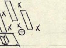
- R14–R15
- R13–R14
- R12–R13
- R11–R12
- R10–R11
- R9–R10
- R8–R9
- R7–R8
- R6–R7. 3485 m
- R5–R6
- R4–R5
- R3–R4
- R2–R3
- R1–R2. 3380 m
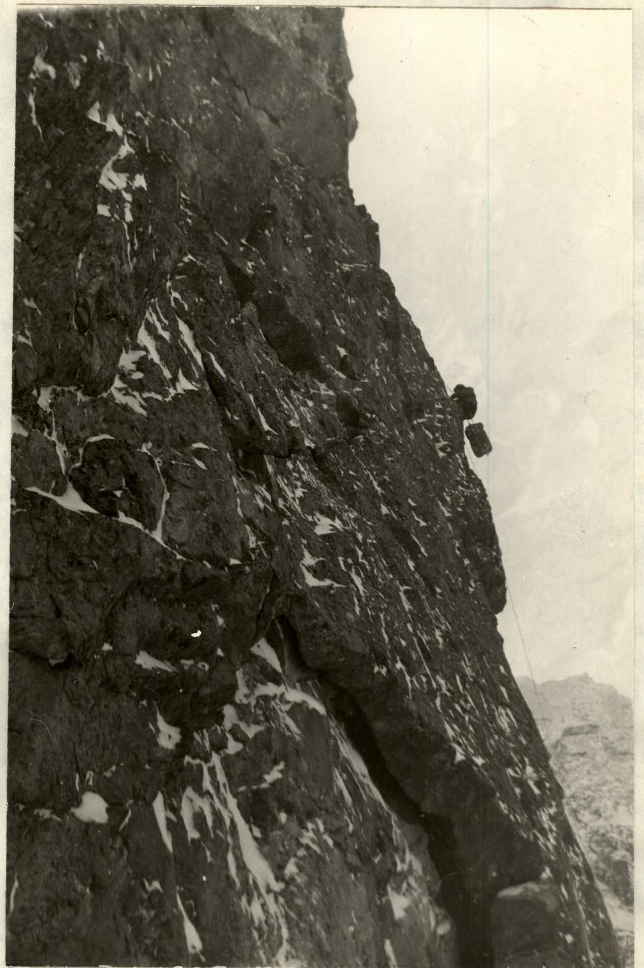
"Mirror of Surka" (R2–R3)

Under the summit tower (R29–R31)
Comments
Sign in to leave a comment