To the Russian Championship in mountaineering in the technical class
Report
on the ascent of the FAiS team from Moscow to v. Shkhelda Central 4295 m via the right edge of the N-wall (5B cat. diff.)
Captain: Nilov S.A. Coach: Kuznetsova E.V.

V. Martynov's 2nd route 5B, 1955 (the route taken by the team);
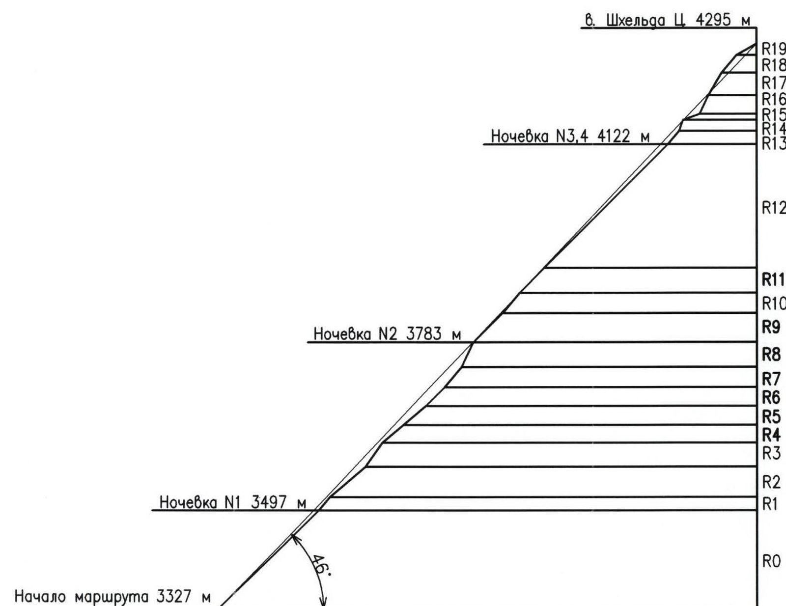
Route Profile
Photopanorama of the area
Photograph by Fomichev O. Taken in August 1994, location — Dvoynoy glacier.
Map of the area
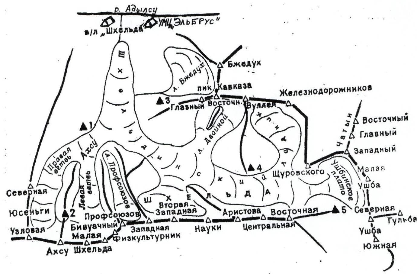
Shkhelda valley map:
- 1 — «Aristov's overnight stay»
- 2 — «Akhsu overnight stay»
- 3 — overnight stays under the Peak of the Caucasus
- 4 — «Shkhelda overnight stays»
- 5 — platforms at the base of the «saw»
Brief overview of the area and the ascent object
Shkhelda Central peak (4295 m) is located in the eponymous valley in the Prielbrusye region (Central Caucasus). Prielbrusye refers to the area located in the upper reaches of the Baksan River (173 km) and its tributaries. Here lies the highest point of the Caucasus — Elbrus. Elbrus is a two-peaked cone of an extinct volcano. The height of the Western peak is 5642 m, the Eastern — 5621 m. The total area of Elbrus glaciers is 134.5 km b²; the most notable ones are: Bolshoy and Maly Azau, Terskol.
Valleys:
- Adyl-Su
- Shkheldinskoye
- Adyr-Su
Massifs:
- Donguzorun
- Ushba
Very popular among mountaineers and hikers.
The Adyl-Su River is a right tributary of the Baksan River and originates from the eponymous valley. The Adyl-Su valley branches off from the Baksan valley just above the Elbrus settlement.
There are three mountaineering camps in the Adyl-Su valley:
- «Shkhelda»
- «Elbrus»
- «Dzhantugan»
An asphalt road is laid from the mouth of the valley to the UMC «Elbrus», and a dirt road continues above, to the «Dzhantugan» alpine camp. From the camp, the road goes all the way to the border post, which is located about halfway from «Dzhantugan» to the «Green Hotel».
The «Green Hotel» is a flat meadow where mountaineers and tourists typically stop. There are ruins of a small hut here. A little higher, at the edge of the Dzhankuat glacier, is the glaciologists' base.
The Shkhelda River is a left tributary of the Adyl-Su River, flowing through the Shkheldinskoye valley and merging with Adyl-Su just above the «Shkhelda» alpine camp. This valley provides access to peaks such as:
- Peak Shchurovskogo
- Chatyn
- Ushba
- Shkhelda
The Shkhelda massif has five peaks (height from 4100 to 4320 m). Its northern slope is home to the Shkhelda glacier (length up to 9.8 km).
- The westernmost peak is Peak Profsoyuzov — 4100 m, with steep icy and snowy northern and western slopes.
- The southern side of the peak has simple rocky slopes and snow-covered, ruined couloirs.
- East of the peak, the Western and Second Western peaks of Shkhelda rise above the ridge.
- From the latter, a long, heavily jagged ridge with numerous rocky spires (peaks) stretches to Peak Nauka — the Builders' Ridge.
- Beyond Peak Nauka, a wide snowy ridge calmly approaches Peak Aristova — 4230 m.
- On the northern slope of this section, in the bend of the ridge between Peaks Profsoyuzov and Aristova, lies a small unnamed ice cirque, which descends steeply into the Shkhelda glacier.
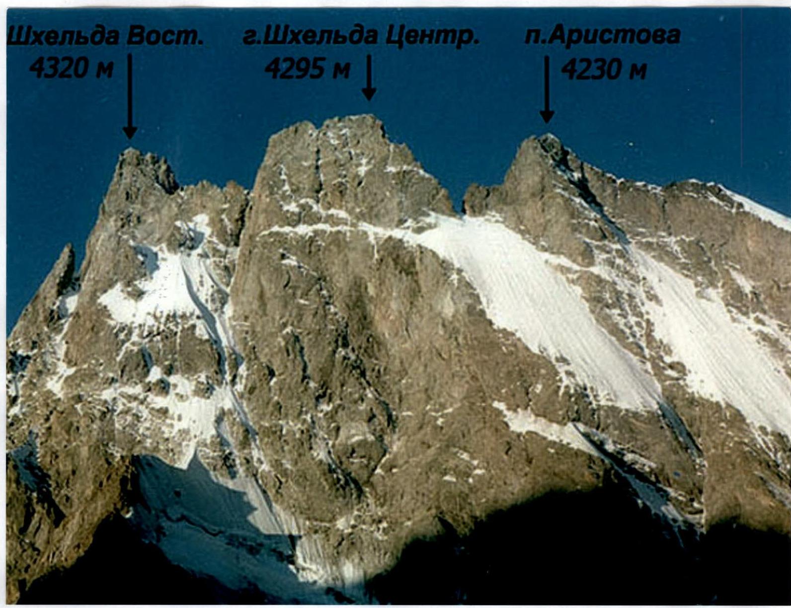
East of Peak Aristova are the massif's peaks:
- Central — 4295 m
- Eastern — 4320 m
To the north, the massif is bounded by monolithic sheer walls, steep icy slopes, and counterforts, typically covered by avalanches and icefalls. The southern, vertically walled upper sections of the massif are heavily destroyed, and rockfalls frequently occur.
The first ascent of the massif was made on August 1, 1903, by a group led by R. Gelbling, who climbed Eastern Shkhelda via the Southeast ridge. Complex, technically challenging northern walls of the massif were unsuccessfully attempted by groups such as:
- G. Deberlya,
- B. Bochek and R. Spitzera,
- F. Krobata and H. Peterka,
- A. Maleinov and others, but the first successful ascent was achieved by F. Kropf and P. Zarichnyak, who stormed the North wall of Central Shkhelda from July 14 to 25, 1936, in bad weather. In 1940, two groups almost simultaneously traversed the massif: one from west to east — L. Nadezhdina's group, and the other from east to west — V. Nesterov's group.
To date, over 20 routes have been established to the peaks of the Shkhelda massif, ranging from 2B to 6A cat. diff.
Ascent Schedule
Route diagram in UIAA symbols
| Section # | Pitons | UIAA Diagram | Length, m | Steepness, deg | Category of difficulty | Photo # | ||
|---|---|---|---|---|---|---|---|---|
| rock | incl | ice | ||||||
| R19 | 40 | 30 | 3 | 8 | ||||
| R18 | 4 | 3 | 40 | 50 | 4 | 7 | ||
| R17 | 8 | 5 | 45 | 60 | 6 | |||
| R16 | 1 | 3 | 35 | 65 | 5 | |||
| R15 | 3 | 3 | 30 | 20 | 4 | |||
| R14 | 2 | 20 | 70 | 5 | ||||
| R13 | 3 | 1 | 30 | 50 | 5 | 5, 6 | ||
| R12 | 48 | 300 | 45 | 4 | 3, 4 | |||
| R11 | 4 | 1 | 60 | 45 | 4 | |||
| R10 | 4 | 1 | 45 | 50 | 5 | |||
| Section # | Pitons | UIAA Diagram | Length, m | Steepness, deg | Category of difficulty | Photo # | ||
| :-------: | :----: | :--: | :--: | :----------: | :------: | :------------: | :---------------------: | :------: |
| rock | incl | ice | ||||||
| R9 | 70 | 45 | 4 | 2 | ||||
| R8 | 10 | 4 | 47 | 65 | 6 | 1 | ||
| R7 | 5 | 2 | 45 | 50 | 5 | |||
| R6 | 2 | 2 | 45 | 45 | 4 | |||
| R5 | 3 | 50 | 40 | 3 | ||||
| R4 | 3 | 47 | 40 | 3 | ||||
| R3 | 5 | 4 | 50 | 55 | 5 | |||
| R2 | 80 | 40 | 4 | |||||
| R1 | 2 | 1 | 30 | 50 | 5 | |||
| R0 | 240 | 45 | 3 |
Route description by sections
| Section # | Description |
|---|---|
| R0 | Ice-snow couloir leading to a rocky outcrop with a ledge for overnight stay. |
| R1 | Up 30 m. Via simple ice-covered rocks to a rocky outcrop. There's a red rappel loop on two titanium channels. |
| R2 | Move slightly left, up the snowy slope under the wall to a piton with a red rope loop. |
| R3 | 5 m left under an indistinct couloir. Then up the couloir 30 m, after exiting onto simple rocks another 15 m up, and slightly right to a bollard with a black strap. There is a station. |
| R4 | Right and up the snowy slope to a rocky tooth 2 m high. Station on the tooth. |
| R5 | From the rocky tooth, right along the slope to a large rocky slab. Station on the slab. |
| R6 | Passing the slab on the right, move up the ice-filled, indistinct internal angle. Upon exiting onto simple rocks — station. |
| R7 | Directly up the ice-covered rocks to the base of the internal angle, then station. |
| R8 | Directly up the internal angle. Climbing is very difficult, few handholds, walls are covered in ice. Protection points are unreliable. At the exit from the internal angle, on its right side — a station bollard. |
| R9 | Up the snowy slope directly under the rocky belt, protection on rocks. Traverse 30 m left along the rocks to a safe place for overnight stay. Organize a bivouac on the border of snow and rocks, slightly left of an indistinct couloir. |
| R10 | Right and up simple rocks. After 45 m — station, 2 local pitons. |
| R11 | Traverse the slope right, gaining little height, exiting onto the «shovel». |
| R12 | Up the ice board to the pass between Shkhelda C. and Peak Aristova. Protection on ice screws. Upon reaching the pass, descend 25 m down and right to its southern side. There's an opportunity to carve out a small platform for two people in the ice slope. Organize a bivouac. |
| R13 | From the pass, up the simple rocks of the internal angle 30 m. Make a station. |
| R14 | From the station, up and right, exiting onto the ridge. |
| R15 | Adhering to the right side of the ridge, approach the ice-filled internal angle. |
| R16 | Up the internal angle directly to the base of the rocky slab. |
| R17 | Up the rocky slab to the pre-summit tower. Rocks are covered in ice. |
| R18 | Via simple rocks covered in snow to the pre-summit ridge. |
| R19 | Along the ridge to the summit. Protection through terrain. Simultaneous movement. Movement is hindered by a high probability of snow cornice collapse. |
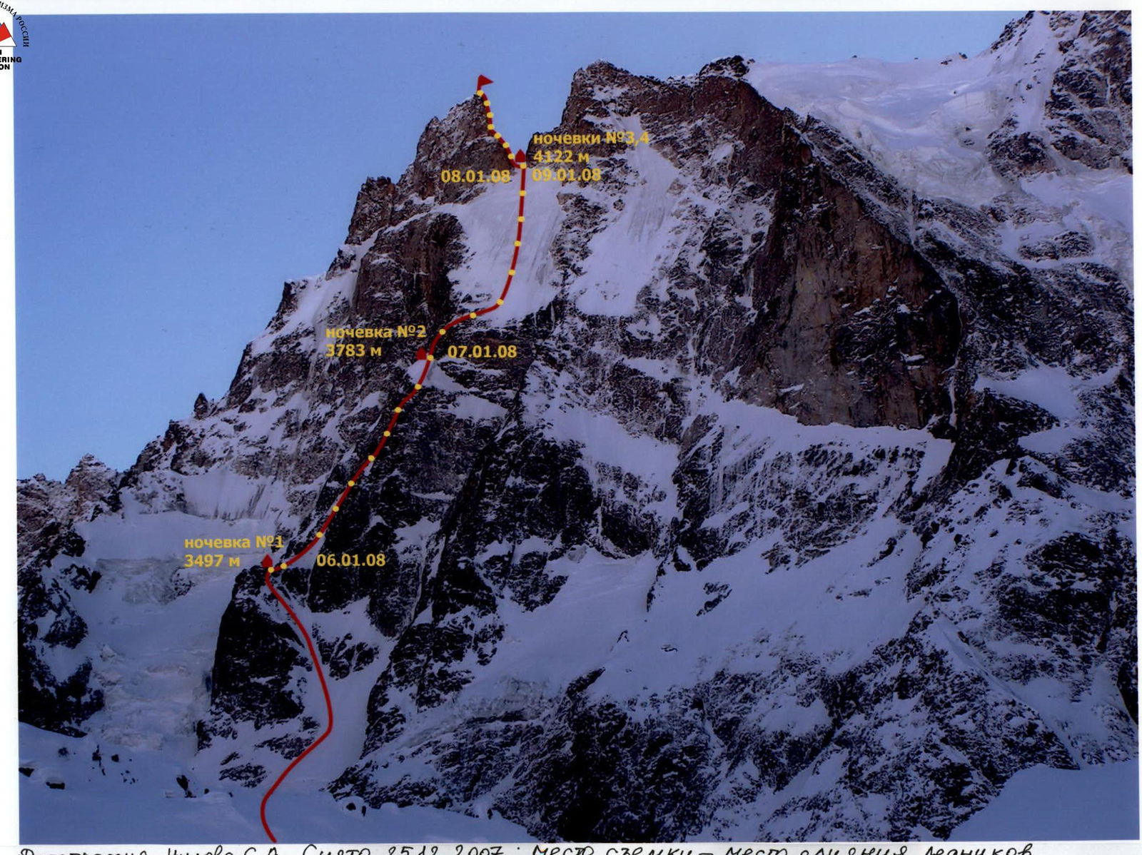
Photograph by Nilov S.A. Taken on December 25, 2007; Location — confluence of Dvoynoy and Shkhelda glaciers.
Note from the summit
Summit note
- On August 19, 2005, at 19:00, a group from N. Tachena, consisting of Ravilov R.A. (leader), Karvinov K.P., Gorshkov E.M., Khoroshinov K.N., Kononenko A.A., ascended to the summit of Shkhelda C. via the Polevoy route, 6A cat. diff. Weather conditions: thunderstorm. Descent via route 2 started at — h — min. Group leader: Ravilov (signature, surname).
Preparation for the ascent
The team prepared for the ascent over the course of a year. The planned route required participants to have serious physical and technical preparation. A plan was drawn up, including general physical and special technical training, as well as the selection of necessary equipment.
Various sports activities were conducted:
- Rock climbing training
- Skiing
- Running
Team members participated in international marathons over distances of 42 km 195 m. Repeatedly, the team made training trips to natural terrain. In the autumn, joint training ascents were made on routes of V–VI cat. diff. on Crimean massifs.
Great attention was paid to safety measures, including:
-
Checking the condition of equipment
-
Monitoring weather conditions
-
Briefing participants before departure
-
Availability of a first-aid kit and communication means
-
Designating responsible individuals for the group
-
All team members were physically, technically, and psychologically prepared to tackle the chosen route and had experience climbing in the Central Caucasus mountains;
-
The leader, Nilov S.A., had experience leading 6A cat. diff. routes and participating in 6B cat. diff. routes; Zlokazova N.S. — experience leading 5B cat. diff. routes and participating in 6A cat. diff. routes, Grigoryev D.Yu. — experience leading 5A cat. diff. routes and participating in 5B cat. diff. routes.
-
The team had a comprehensive route description.
-
Excellent material support. Modern equipment and gear were available;
-
The group had a well-stocked first-aid kit;
-
Weather conditions and terrain state were taken into account.
-
Regular radio communication (three times a day) was maintained with the team coach and observers at the UMC «Elbrus» throughout the ascent.
The team's release for the ascent was carried out in accordance with the «Rules...». The release was authorized by Kuznetsova E.V., CMS, 1st category instructor (certificate № 539).
Tactical plan for the ascent
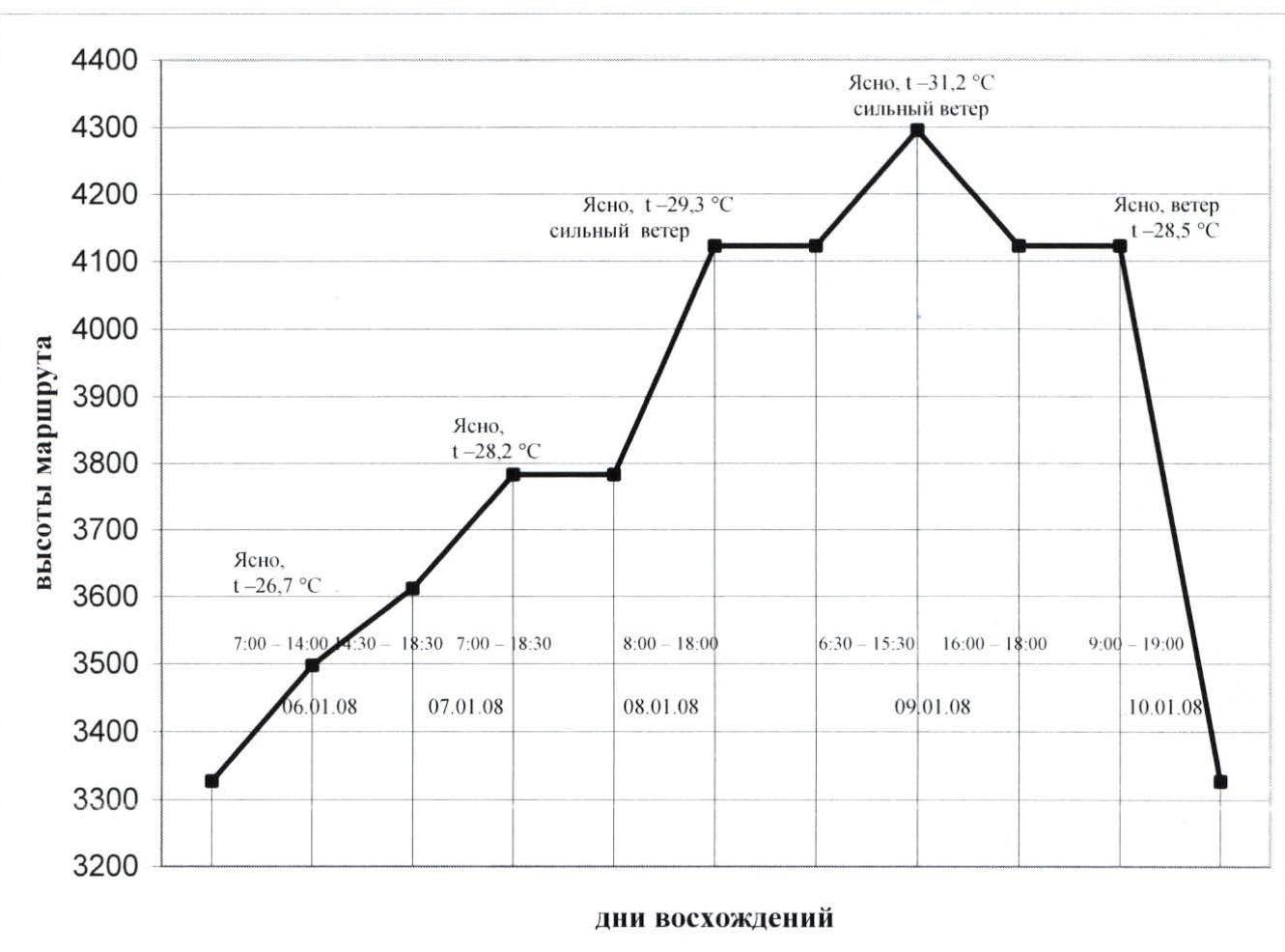
On January 5, 2008, the team departed from UMC «Elbrus», spending the night on the Shkhelda glacier at a safe distance from the wall. According to the previously planned schedule, they started the route on January 6 at 7:00. According to official data from the North Caucasus Hydrometeorological Center, the minimum daily temperature during the ascent averaged −28.9 °C (see Appendix)¹, so special attention was paid to warm clothing. Each team member had two sets of warm gloves, gaiters, and down jackets. Two conjoined down sleeping bags were taken for overnight stays. When packing up the bivouac, it was necessary to account for the condensation that formed in the sleeping bags and tent, which needed to be frozen before packing into the backpack.
The team's tactical plan did not include preliminary route processing. An exception was made for the first day of the ascent (January 6, 2008), when the team reached the first overnight stay location at 14:00. They took a short rest and had a snack. Grigoryev Dmitry remained to set up the bivouac, while the Nilov-Zlokazova rope team processed sections R1, R2, and R3.
The team worked on the route until evening twilight, after which they settled in for the night, using a three-person tent. Water supplies were replenished at the overnight stay. Water was melted from snow and ice. A two-course hot meal was planned (morning and evening), as well as a snack during the day with hot tea in thermoses (0.5 and 1 l). The food ration was calculated at 500 g per person per day.
Initially, all team members worked on the route. Key sections were climbed using free climbing techniques. The first climber worked with two dynamic ropes, and the third rope (static) was hung for the third participant to follow on via ferrata. The group had:
- 2 large backpacks
- 1 small backpack
The leader worked with the small backpack and sometimes without it. The work on the route was complicated by low air temperatures and challenging terrain conditions.
¹ As is known, in winter, the air temperature in the Caucasus drops by 0.3 °C for every 100 m of ascent.
Although there was no precipitation during the ascent, the terrain (especially on ledges) was covered with snow. Since the route's exposure is northern, snow and ice were practically everywhere on the wall section: crevices were filled with ice; walls were also covered in ice; icy rocks were present even on key sections (R8, R17).
Interaction with other teams working in the area and observers was maintained via radio communication according to a pre-established schedule.
The group was monitored from the base camp using binoculars.
On January 7 at 7:00, they continued their movement. Nilov Sergey tackled the key sections (R7, R8). By 18:30, they reached the rocky belt under the «shovel» and set up a bivouac under the rocks on a snowy slope, clearing the top layer. The second overnight stay, like the first, was quite comfortable.
Setting up the bivouac took no less than two hours, as the platform had to be dug out. To equip the bivouac, it was necessary to have:
- Avalanche shovel
- Ice tools
On January 8 at 8:00, they began moving and soon reached the «shovel». Initially, all team members worked on the route, taking turns. By 18:00, they reached the pass between Shkhelda C. and Peak Aristova and started searching for a suitable bivouac site.
A suitable spot was found 25 m below the pass on its southern side, on the right side of a snowy couloir (when descending to the southern side).
It is also possible to dig a comfortable platform on the southern side, 50 m below the pass, on the left side of the snowy couloir, at the border between rocks and snow.
The overnight stay was on a sloping, narrow ledge. The description indicated that a platform for two people could be carved out on the southern side of the pass. However, the group that wrote the description passed the route in the summer. In winter conditions, finding a suitable spot was challenging due to the snow-covered terrain. The snow was frozen, very hard, and in some places, it was solid ice with embedded rocks. When digging, it became clear that the snow and ice layer was not very thick (the tool soon hit the rock), and the slope was quite steep (about 45°). Searching for a suitable platform took 1 hour. They had to carve out the ice and build up the platform with ice and compressed snow chunks. However, it was not possible to significantly increase the bivouac area. As a result, the tent could not be fully set up, and these overnight stays were semi-reclined. Preparing the bivouac took 3 hours.
On January 9 at 6:30, leaving the camp on the pass, they continued towards the summit. The weather was good, but very cold, with strong winds. Throughout the ascent days, the air temperature was quite low, and on January 8 and 9, the participants recorded −35 °C. According to the «Shkhelda» RPS, several groups dropped out due to severe frosts between January 6 and 10, 2008. At 15:30, they reached the summit, wrote a note, placed it in a waterproof capsule, and began their descent. The descent from the summit to the camp on the pass followed the ascent route. By 18:00, they were back at their tent.
On January 10 at 9:00, they began descending from the pass via the ascent route and by 19:00 were on the Shkhelda glacier under the start of the route. By 22:00, they returned to UMC «Elbrus».
The ascent via the right edge of the North wall of v. Shkhelda C. was carried out in full accordance with the planned route and without deviation from the tactical plan.
Equipment table
| # | Equipment Name | Unit of measurement |
|---|---|---|
| 1 | Rope 50 m | 3 (2 dynamic, 1 static) |
| 2 | Carabinerers with screw links | 22 |
| 3 | Rock hammer | 2 |
| 4 | Ice axe | 5 |
| 5 | Crampons | 3 pairs |
| 6 | Rock pitons | 20 |
| 7 | Ice screws | 8 |
| 8 | Stoppers | 11 |
| 9 | Camalots | 8 |
| 10 | Quickdraws with carabiners | 28 |
| 11 | Jumar ascenders | 3 |
| 12 | Ascender | 1 |
| 13 | Descenders (figure 8) | 3 |
| 14 | Anchor loops | 8 |
| 15 | Harness | 3 |
| 16 | Cow's tails / Self-belay devices | 6 |
| 17 | Extractor | 1 |
| 18 | Repschnur (expendable) 30 m | 1 |
| 19 | Helmets | 3 |
| 20 | Boots | 3 pairs |
| 21 | Down jacket | 3 |
| 22 | Sleeping bags | 2 |
| 23 | Sleeping mats | 3 |
| 24 | Tent | 1 |
| 25 | Headlamps | 3 |
| 26 | Gas stove | 1 |
| 27 | Gas cylinders | 4 |
| 28 | Lighters | 3 |
| 29 | Cookware | 1 |
| 30 | Thermos | 2 |
| 31 | Radio station | 1 |
| 32 | First-aid kit | 1 kg |
| 33 | Camera | 2 |
| 34 | Watches | 3 |
| 35 | Sunglasses | 3 |
| 36 | Backpacks | 3 |
| 37 | Waterproof clothing set | 3 |
| 38 | Notebook (Pencil, Pen) | 1 / 1 / 1 |
| 39 | High-calorie, quickly prepared food products | 7.5 kg |
Photos from the route
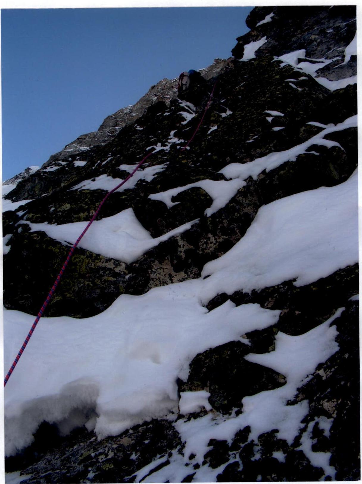
Photo №1. Work on section R8.
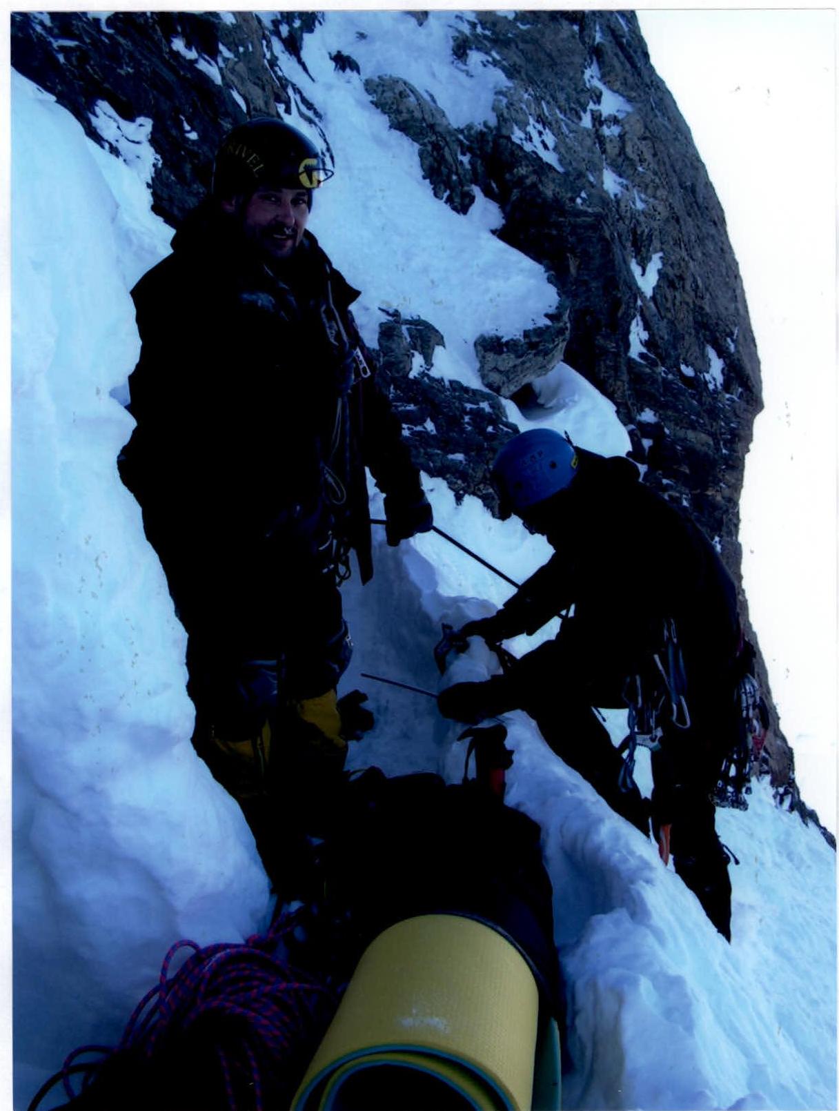
Photo №2. Overnight stay on R9, 3783 m.
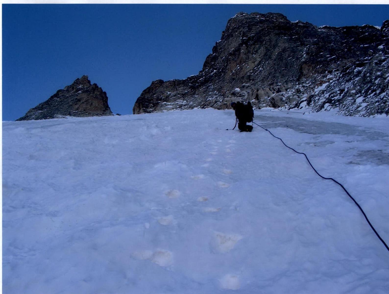
Photo №3. Passage of the «shovel», section R12.
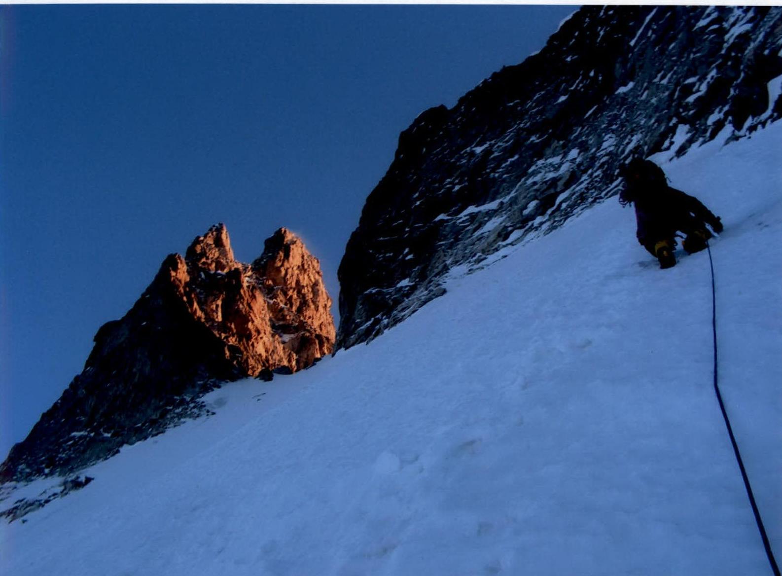
Photo №4. Exit from the «shovel» onto the pass, section R12.
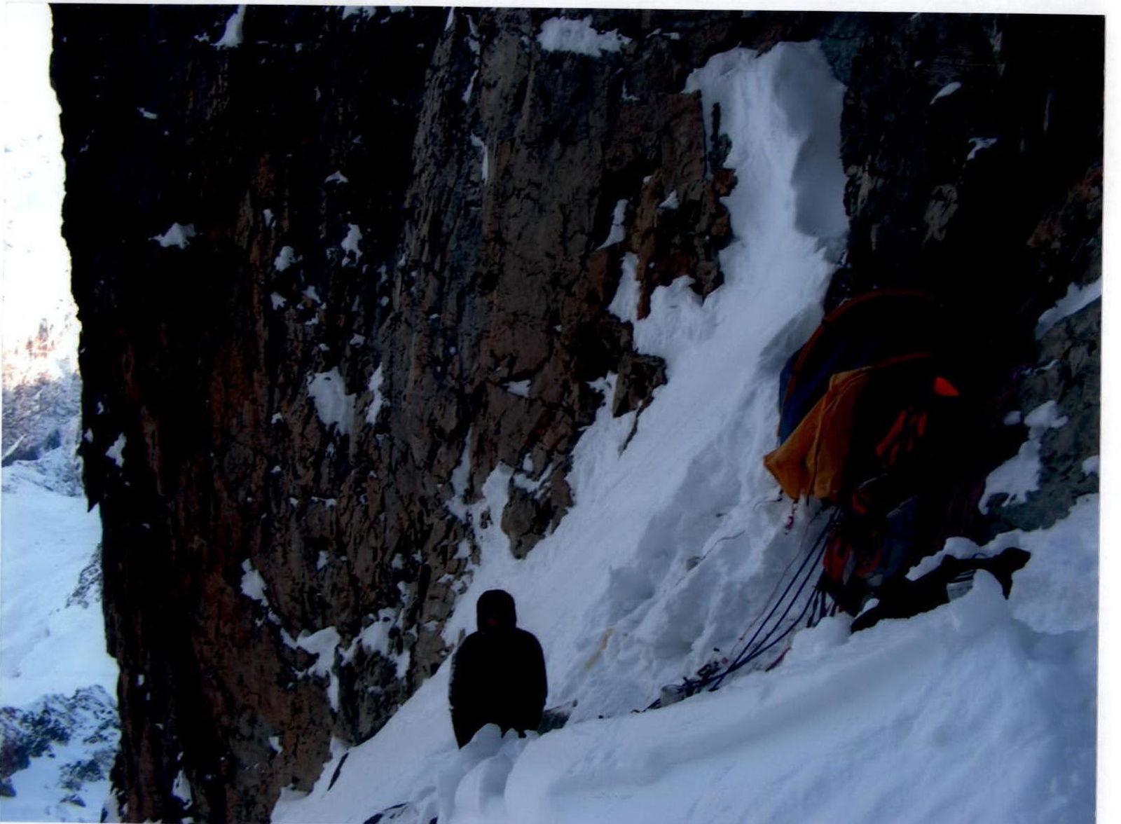
Photo №5. Overnight stay on R13, 4122 m.
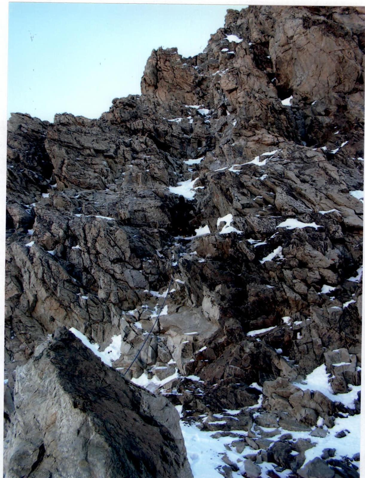
Photo №6. Work on R13.
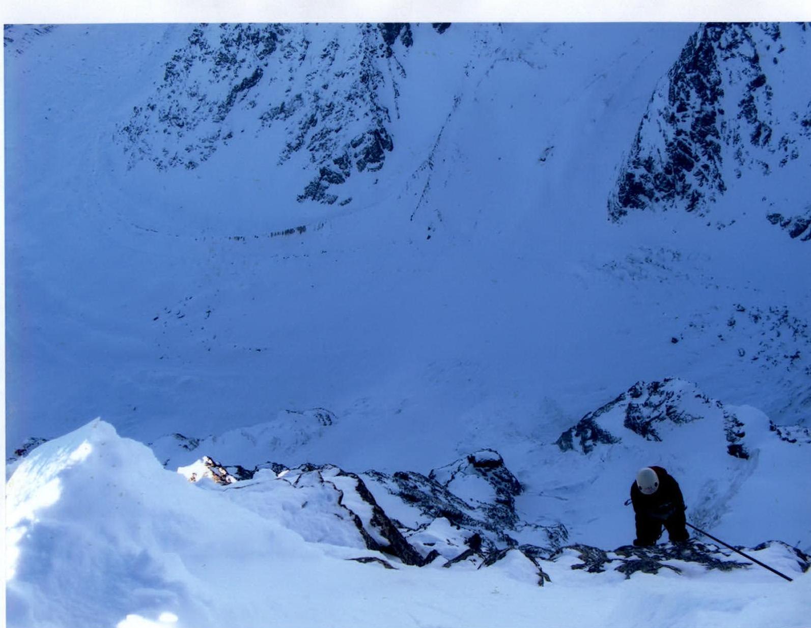
Photo №7. Ascent via the via ferrata, section R18.
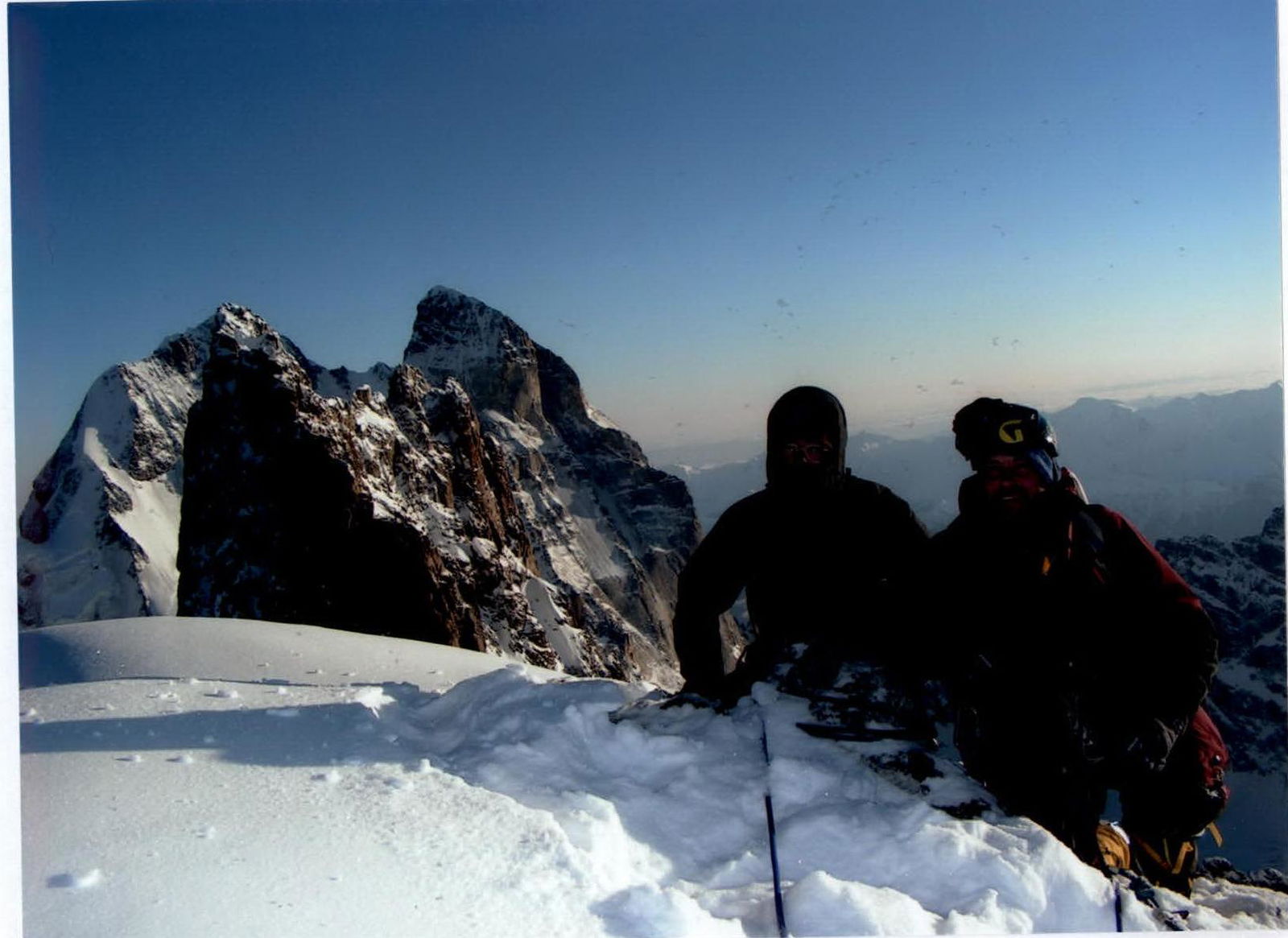
Photo №8. At the summit, near the control post, R19.
Appendix

ROSHYDROMET
SE «ROSTOV TSGMS-R» North Caucasus Hydrometeorological Center — branch of SE «Rostov TSGMS-R» (SK GMC)
Erevan St., 1/7, Rostov-on-Don, 344025. Tel./fax (8 863) 251 48 09. Telex: ROSTOV GMC. E-mail: meteo@aaanet.ru
April 2, 2008 № 07-12/354
To ____ from ____
To the President of the Central Sports Club of Mountaineers, Master of Sports in Mountaineering V.G. Volodin
In response to your request, I am reporting the minimum air temperature in the mountains of Kabardino-Balkaria from January 6 to 10, 2008, according to observations from the Terskol weather station:
- January 6 — −22.6 °C
- January 7 — −23.2 °C
- January 8 — −23.3 °C
- January 9 — −24.7 °C
- January 10 — −22.5 °C
Head of SK GMC
Voloshina 251 44 72

T.A. Larina


