Report
on the ascent to the summit of Shkhelda 3rd Western (4229 m) via the North face of the North-West ridge, category 5B, undertaken by the team of alpinist camp "Varzob" UA VS DSO trade unions
from July 30 to July 31, 1984
Team captain — Oleg Viktorovich Kapitanov, Team coach — Oleg Viktorovich Kapitanov. Addresses:
- alpinist camp "Varzob" — 734003, Dushanbe, post office box 362
- Team captain — 734061, Dushanbe, ul. 50 let Tadzhikistana, d. II, kv. 4, Kapitanov Oleg Viktorovich
Altitude measurement was done using altimeter AV No. 714568. Steepness was determined visually and with the help of a protractor.
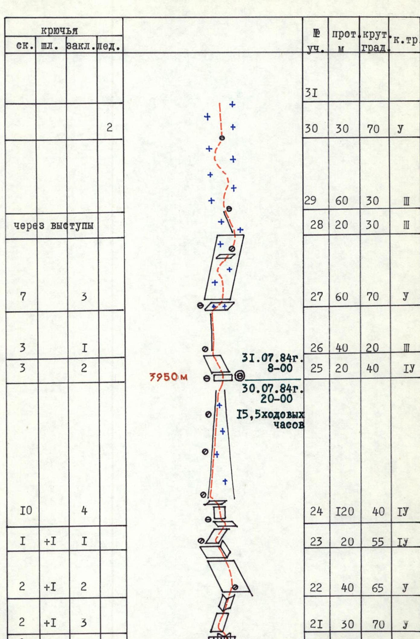
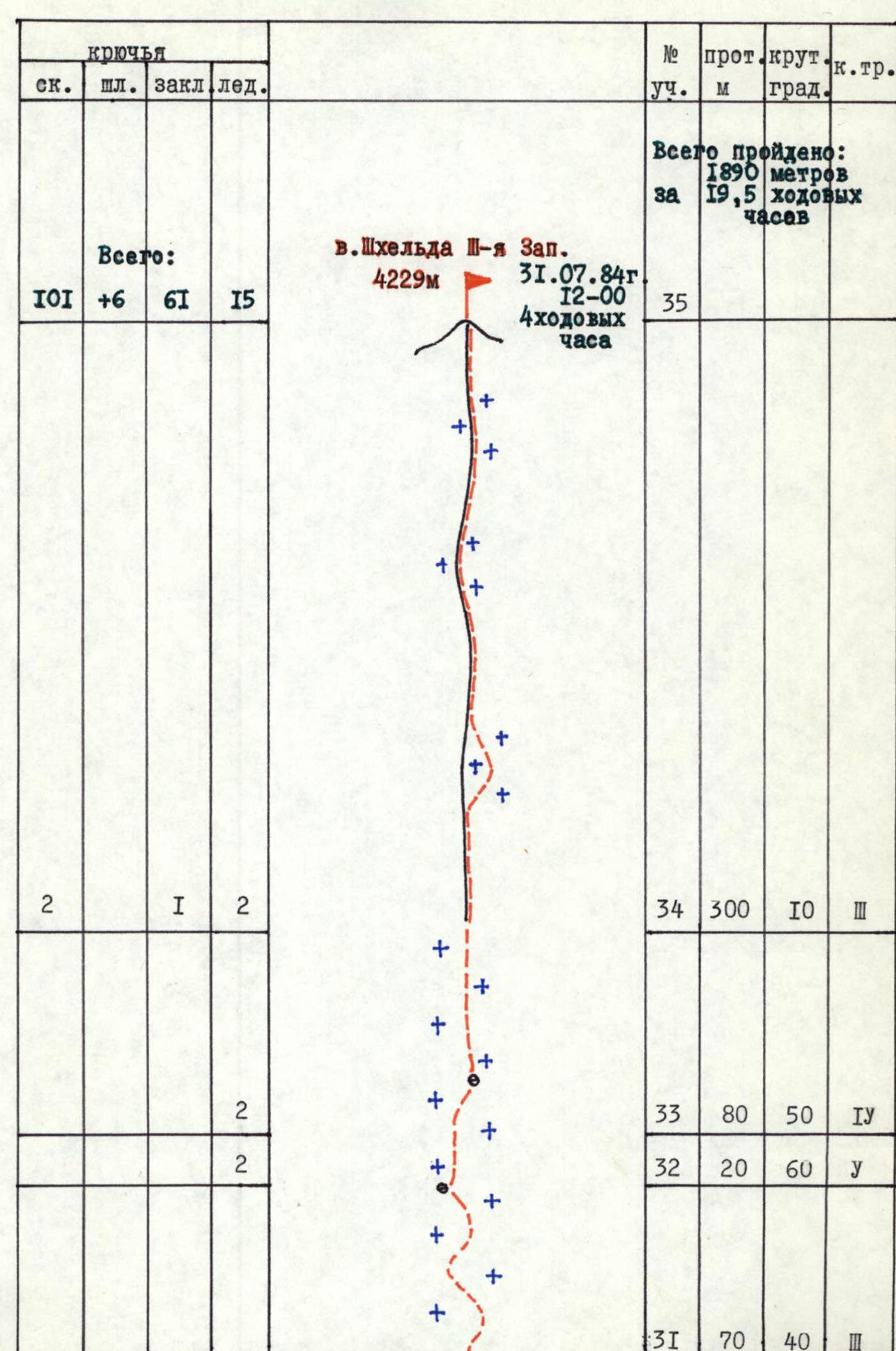
Profile of the route to the summit Shkhelda 3rd Western (4229 m) via the North face of the NW ridge (view from the left)
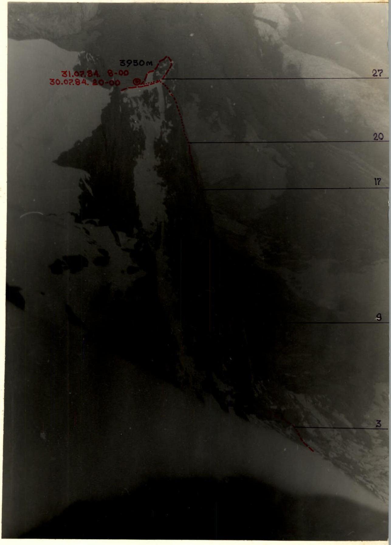
PHOTO-2 Date taken — July 31, 1984. Distance — 1.5 km. Time taken — 12:00. Shooting point — 2. Lens — Industar 52/2. Shooting height — 4100 m. Profile of the route to the summit Shkhelda 3rd Western (4229 m) via the North face of the NW ridge (view from the right)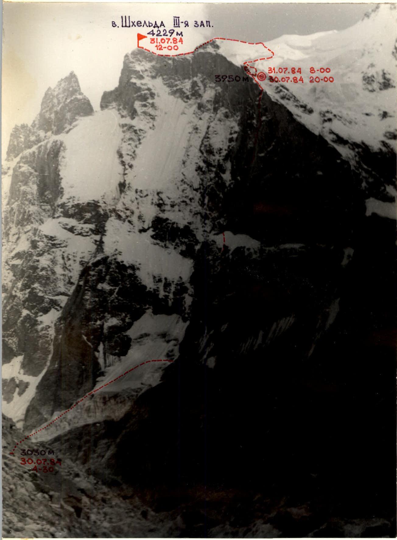
PHOTO-3 Date taken — July 28, 1984. Time taken — 15:00. Lens — Luber-166.
Distance — 3 km. Shooting point — 3. Shooting height — 2800 m. Photopanorama of the area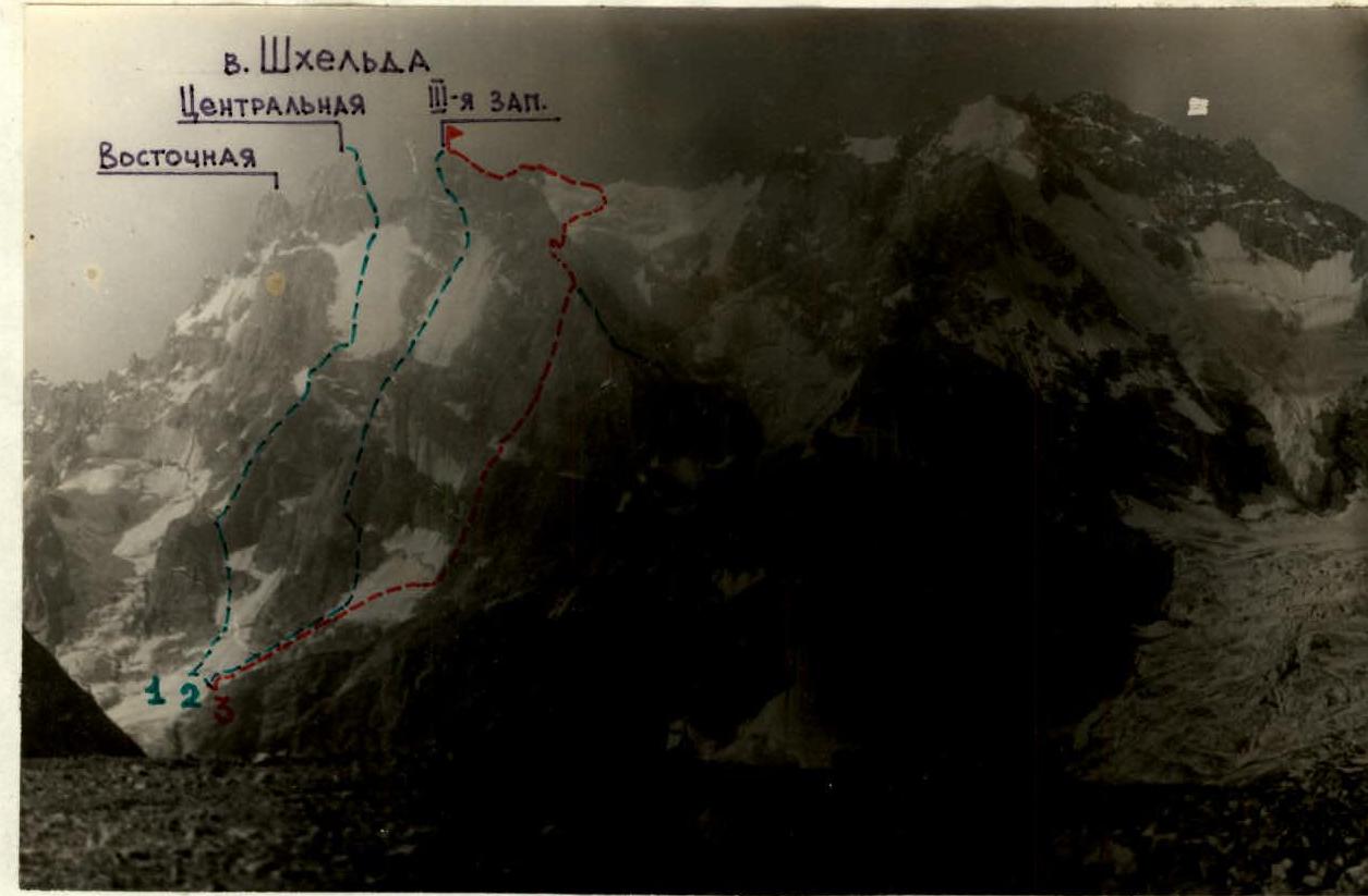
PHOTO-4
Date taken — July 28, 1984. Distance — 3 km. Time taken — 15:00. Shooting point — 4. Lens — Industar 52/2. Shooting height — 2800 m.
1 — Martynov's route on Shkhelda Central via the right edge of the N face, category 5B 2 — Yeliseyev's route on Shkhelda 3rd Western via the N face, category 5B 3 — Kensitsky's (Rototaev's) route on Shkhelda 3rd Western via the N face of the NW ridge, category 5B 4 — Abalakov's route on Shkhelda 3rd Western via the NW ridge, category 5A
Preparation for the Ascent
In the XXXV USSR Alpine Championship in the rock climbing class, the team from alpinist camp "Varzob" UA VS DSO trade unions was represented by:
- MS — Kapitanov O.V.
- Glushko V.I.
- Rusyaev A.V.
- CMS — Igolkin V.I.
- Kotelnikov A.I.
- Parshin V.S.
In preparation for the Championship, the team studied reports from previous teams that had climbed these routes, made photocopies of them, and received consultations from A. Makhinov, F. Zhitinev, A. Moshnikov, and others who knew the climbing area well. They also studied necessary materials from A.F. Naumov's book "Baksan Valley".
Before heading to the mountains, team members trained 4-5 times a week in their local sections. Training in the mountains took place in the area of alpinist camp "Varzob" in the spurs of the Gissar Ridge. By the time they arrived at the Championship location, all team members had experience of joint ascents of categories 5B and 6B and had passed the necessary standards.
Equipment, food, and first aid kit were prepared in advance and met modern requirements.
The initial data for the tactical plan for the ascent to the summit of the first round were based on reconnaissance data and a detailed study of the routes by the team during the training camp from July 11 to July 19, directly in the climbing area, studying KSP documentation, and having equal partnerships within the team, as well as considering the unstable weather in the area.
The tactical plan for the second round was based on the experience of the previous ascent, taking into account all shortcomings and errors identified during the conquest of peak Shchurovsky.
In the second round, the team chose an interesting, complex, and logical route to v. Shkhelda, 3rd Western via the N face of the NW ridge (Kensitsky's variant), the main problem of which was a 300-meter rock wall, known as the "triangle". The problem lay in the great steepness and length of this bastion, mostly consisting of smooth slabs, internal corners, and overhanging sections, which significantly hindered free climbing.
The solution was to include strong rock climbers in the team, good technical and psychological preparation, and the use of modern equipment.
Ascent Schedule
 □ — time moving along the route □ — fog, strong wind on the route
Tactical Actions of the Team
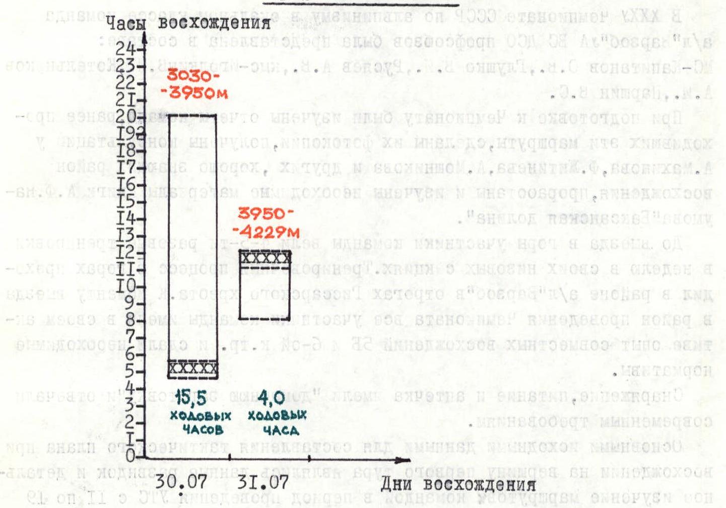
The tactical plan provided for climbing the route with one bivouac without prior processing. The route was completed in 19.5 hours of climbing time from July 30 to July 31, 1984. Considering the team's excellent physical condition and the possibility of worsening weather, the plan allowed for prolonged loads of up to 16 hours a day. The strong and balanced team composition allowed the first rope teams to work on sections as follows:
- R0–R9 — Rusyaev–Glushko;
- R9–R24 — Igolkin–Kapitanov;
- R24–R29 — Glushko–Rusyaev;
- R29–R35 — Kotelnikov–Parshin.
The full registered team composition and interchangeability determined the possibility of necessary changes in leading and trailing climbers and dosing their physical and psychological loads. The load on participants was approximately even. The first climber worked without a backpack, the last with a lightened one. Due to good physical preparation, climbing vertical fixed ropes was done with a backpack. All participants had double safety insurance. Each rope team performed a specific task:
- 1st team sets up fixed ropes (where necessary);
- 2nd team moves along the fixed ropes and passes equipment to the 1st team;
- 3rd team moves along the fixed ropes, passes equipment to the 2nd team, and removes the fixed ropes.
Bivouac equipment was designed for a shared overnight stay. The main principle for choosing a bivouac site was safety.
First day. July 30, 1984. The main task was to overcome the key section of the route — the North face of the NW ridge, a 300-meter rock wall, conditionally called the "triangle". The main difficulty was smooth, steep, and in places overhanging sections. The actual state of the route added psychological tension during its passage (rockfall in the middle part of the "triangle", loose rocks on ledges). Considering this, the second and third rope teams often had to gather together in safe places while the leading team worked.
The team started the route at 4:30 and by 20:00 had passed the "triangle" due to high individual technique and coordinated team work. A bivouac was set up on a convenient ledge, protected from the wind. The overnight stay was in a tent, lying down. Climbing time — 15.5 hours.
The main method of overcoming the key section was extremely difficult and psychologically tense free climbing using modern equipment and high-level rock climbing techniques.
Second day. July 31, 1984. Cold and strong winds on the ridge of the "triangle" did not allow the team to start the route before 8:00. The problem of the day was to overcome icy rock ascents and a snow-ice slope leading to the main ridge. The solution was to have the team's best snow and ice specialists pass these sections.
The team reached the main ridge by 11:00 and was on the summit by 12:00. From 11:00, the weather deteriorated sharply. The summit ridge was traversed in conditions of limited visibility, strong wind, and snowfall. Climbing time — 4 hours.
Thus, the route was completed in full accordance with the tactical plan, ahead of the time schedule by 2.5 hours.
The descent was slow, also in conditions of limited visibility and gusty winds. Considering the heavy snow load on the descent couloir, they descended along the rocks, pulling the rope after them. The descent was carried out clearly thanks to detailed consultation received from the team of DSO "Lokomotiv".
Safety measures on the route included:
- high physical, technical, and psychological preparation of all team members;
- a tactical plan drawn up considering the experience of the first round's ascent, detailed reconnaissance, and observations of the route;
- good material support with modern equipment and a diverse range of quality food products;
- the presence of a highly qualified observation group with a CMS rank under the route.
The route included hot meals and snack breaks. The daily ration was 350 grams per person per day.
The team was provided with regular and high-quality radio communication according to the scheme "wall–observer", "observer–rescue team".
Route diagram in IAA symbols

| Section | length m | steepness deg. | tech. grade | pitons | bolts | chocks | ice screws |
|---|---|---|---|---|---|---|---|
| R0 | 200 | 40 | Ш-IY | 3 | |||
| R1 | 20 | 80 | y | 1 | |||
| R2 | 80 | 35 | III | 2 | |||
| R3 | 80 | 40 | Ш-IY | ||||
| R4 | 40 | 70 | y | ||||
| R5 | 80 | 45 | Ш-Iy | 6 | 3 | ||
| R6 | 40 | 50 | Iy | 4 | 1 | ||
| R7 | 60 | 40 | III | 4 | 1 | ||
| R8 | 40 | 45 | IY | 3 | 1 | 1 | |
| R9 | 40 | 60 | Iy | 3 | 2 | ||
| R10 | 20 | 80 | У+ | 3 | 2 | ||
| R11 | 20 | 75 | y | 4 | 1 | ||
| R12 | 30 | 80 | y | 6 | 1 | ||
| R13 | 60 | 85 | y | 10 | 3 | 2 | |
| R14 | 20 | 85 | VI | 3 | 4 | ||
| R15 | 15 | 60 | Iy | 3 | 1 | ||
| R16 | 45 | 85 | VI | 4 | 1 | 5 | |
| R17 | 40 | 70 | J | 5 | 6 | ||
| R18 | 20 | 85 | y | 1 | 3 | ||
| R19 | 20 | 60 | Iy | 2 | 3 | ||
| R20 | 10 | 90 | VI | 2 | 2 | ||
| R21 | 30 | 70 | y | 2 | 1 | 3 | |
| R22 | 40 | 65 | y | 2 | 1 | 2 | |
| R23 | 20 | 55 | Iy | 1 | 1 | 1 | |
| R24 | 120 | 40 | IУ | 10 | 4 | ||
| R25 | 20 | 40 | Iy | 3 | 2 | ||
| R26 | 40 | 20 | III | 3 | 1 | ||
| R27 | 60 | 70 | y | 7 | 3 | ||
| R28 | 20 | 30 | III | via outcrops | |||
| R29 | 60 | 30 | III | 2 | |||
| R30 | 30 | 70 | y | 2 | |||
| R31 | 70 | 40 | III | 2 | |||
| R32 | 20 | 60 | y | 2 | |||
| R33 | 80 | 50 | Iy | 2 | |||
| R34 | 300 | 10 | III | 2 | 1 | 2 | |
| R35 | |||||||
| Total: | 1890 м | 101 | 6 | 61 | 15 | ||
| Total: in 19.5 climbing hours |
Description of the Route by Sections
Approach to the route from the Shkhelda glacier along the ice slope leading to the NW ridge, bypassing crevasses. The start of the route is from the bergschrund crossing the entire ice slope. The bergschrund is passed over a snow bridge with overcoming a wall. (see by sections)
R0–R2 — snow-ice slope with a steepness of 35–40 degrees, intersected by crevasses with a displacement of one to two meters between opposite walls, dense firn with sections of ice. Overcome in the middle part. In the 2nd part of the slope, there are strong breaks, which are overcome by passing vertical walls of the breaks. In the upper part, the slope becomes gentler. A traverse to the right leads to a rocky ridge.
R3–R5 — ascent to the ridge leading under the wall of the NW ridge — a 10-meter wall with a steepness of 75 degrees. The ridge is heavily destroyed, slabs are covered with snow and ice. Passed along the left side of the ridge — 80 m. Further, a 20-meter wall is passed on the right part, then 80 m of the ridge, polished slabs.
R6–R7 — a crevice 40 m, turning into a chimney in the upper part, covered with rime ice.
R7–R9 — a series of walls covered with snow and ice, leading to a steep ice slope. Insurance through ice screws. In the upper part, the bergschrund is overcome via a snow bridge.
R9–R12 — (start of the "triangle") a 3-meter cornice leads to an internal corner (destroyed rocks), in the middle part passed along a ledge (difficult climbing).
R12–R13 — a steep internal corner (overcome "en échelle"). Further, a traverse to a ledge.
R13–R14 — a giant internal corner. Rocks are polished. Movement along ledges, previously hammered pitons are encountered. Difficult climbing.
R14–R15 — a steep wall with a cornice. Passed via a crevice. Climbing of maximum difficulty.
R15–R16 — a smooth internal corner leading to a ledge under a steep wall. The wall is steep with overhangs. Difficult climbing. Passed via a crevice. Exit to a ledge under an overhang.
R17–R18 — traverse to the right along a steep wall.
R18–R24 — steep monolithic rocks with crevices. Chocks are used. Rocks are wet. Previously hammered pitons are encountered. We reach the NW ridge.
R24–R26 — snow-covered rocks of the ridge leading to a snow-ice couloir to the right of the ridge. A convenient area for a bivouac. Bivouac.
R26–R27 — rocky ridge leading under the 2nd bastion.
R27–R29 — along icy internal corners and walls, exit to a snow-ice slope leading to the main ridge. Ice drops.
R29–R30 — along an ice-snow slope, overcoming crevasses and ice slopes, we reach the 2nd ice drop.
R30–R31 — ice drop. Bypassed to the right along an ice wall. Ice axes are used.
R31–R34 — snow-ice ascent leading to the western (summit) ridge.
R34–R35 — along rocks of medium difficulty, covered with snow and ice — exit to the summit.
Descent to the South Shkhelda glacier and through the Becho pass — return to the camp.