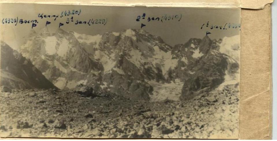
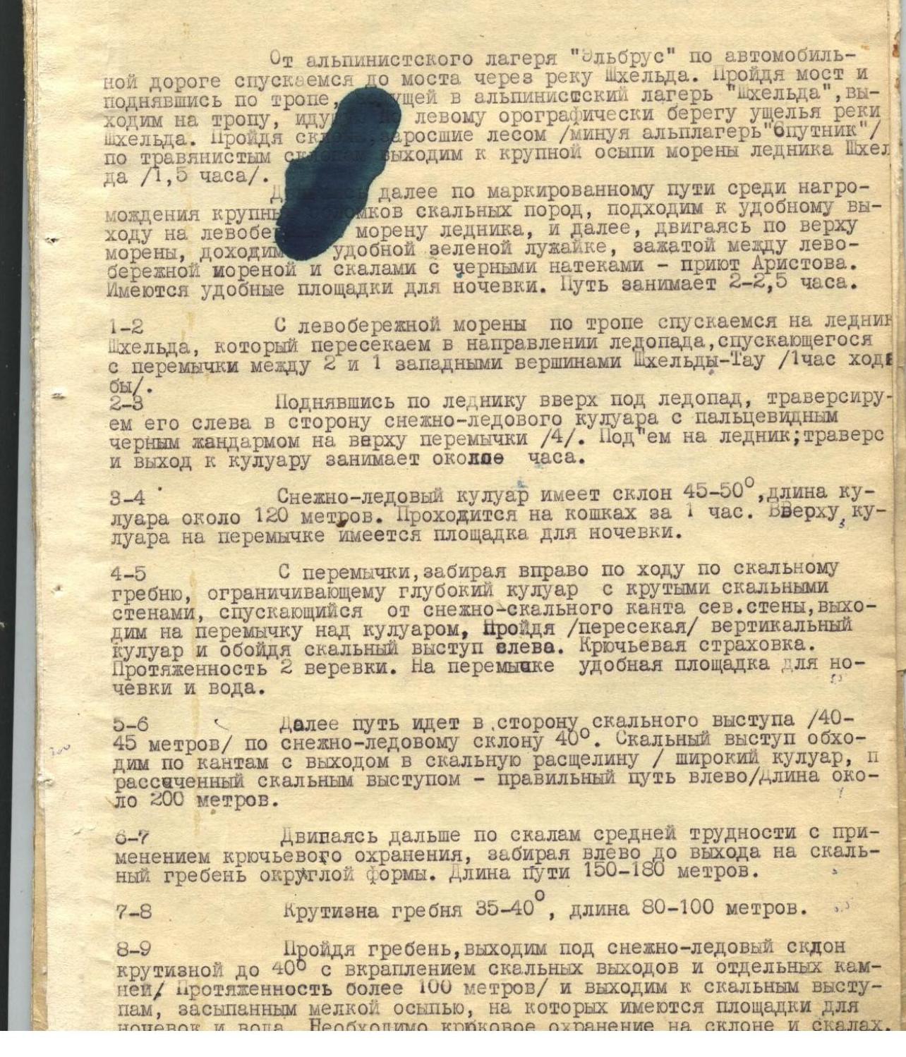
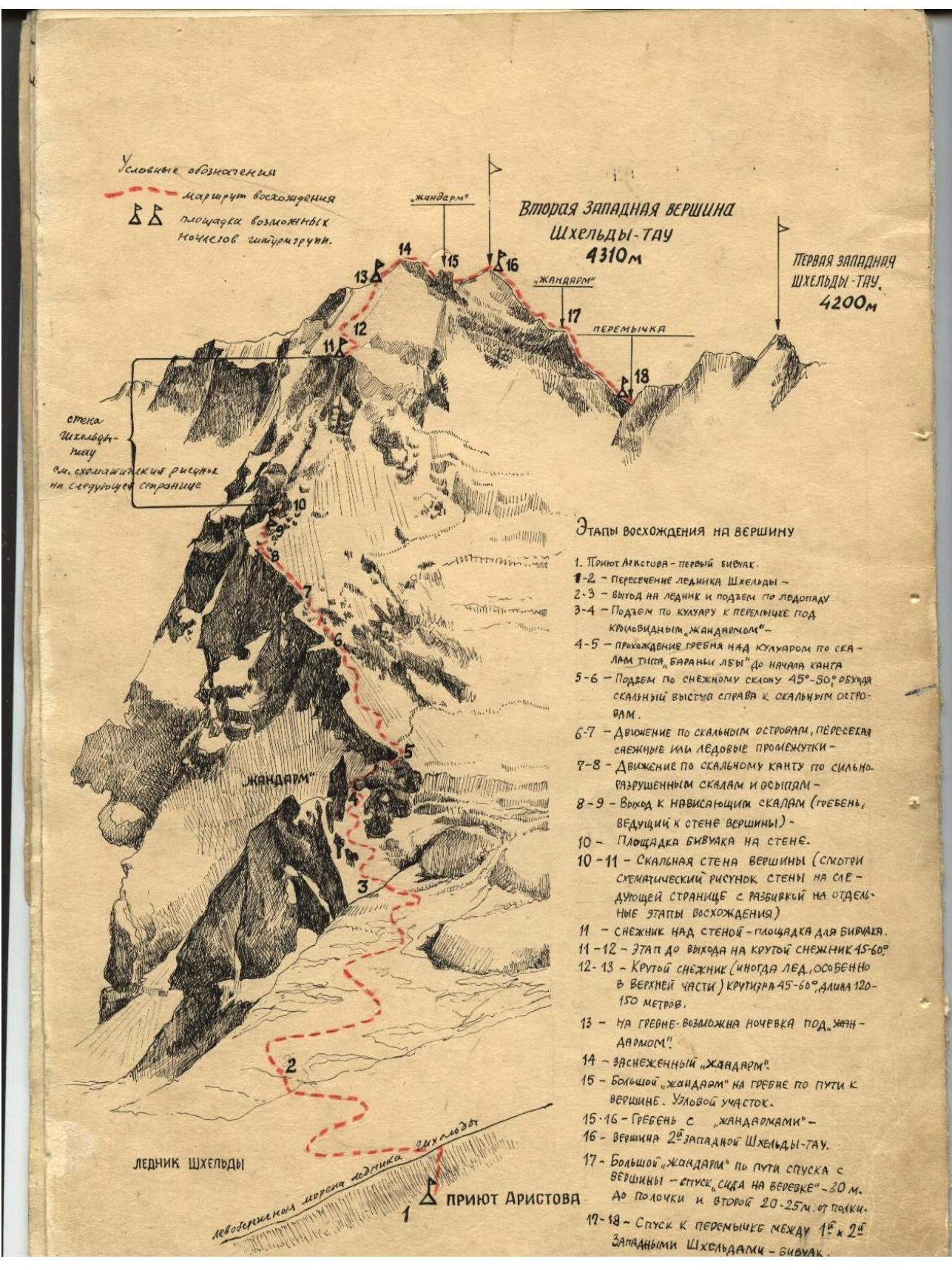
Description of the ascent route to the summit of Iz Zapadnaya Shkheldy Tau via the north wall.
 9–10
from the overnight stay, moving up along the destroyed ridge with small scree,
approximately 200–220 m long, with an exit to rock shelves. Along the shelves, moving
left, we bypass the rock wall approximately — rope lengths. Having bypassed the wall,
moving up to the left of the feather-like rock ridge approximately 150–150 m long with
pitons protection. Further, the route goes along the wall, representing a cascade
of shelves, snow-covered and iced. Rocks protruding from the wall do not have
protrusions convenient for belaying. Piton protection, length 3.0–4.0 rope lengths.
9–10
from the overnight stay, moving up along the destroyed ridge with small scree,
approximately 200–220 m long, with an exit to rock shelves. Along the shelves, moving
left, we bypass the rock wall approximately — rope lengths. Having bypassed the wall,
moving up to the left of the feather-like rock ridge approximately 150–150 m long with
pitons protection. Further, the route goes along the wall, representing a cascade
of shelves, snow-covered and iced. Rocks protruding from the wall do not have
protrusions convenient for belaying. Piton protection, length 3.0–4.0 rope lengths.
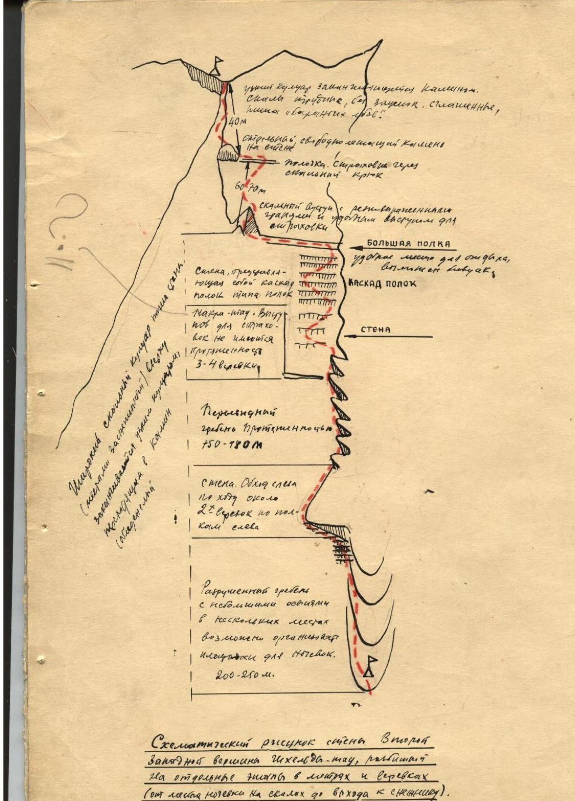
Moving further, we approach a large horizontal shelf (width 100 m, length about 10 m), from which the actual 1st part of the route begins. On the shelf, moving left, we approach a frosty rock outcrop with a sharp edge, having convenient protrusions for belaying.
Having climbed 60–70 m up, we exit to a small shelf, along which, traversing left for several meters towards a large detached stone, we approach the exit to a couloir, which, narrowing, turns into a chimney. From the stone to the exit to the top of the wall — 40–45 m of difficult rocks, iced on top. Piton protection is necessary.
At the top of the wall — a snow patch and on the destroyed rocks — rock scree and convenient areas for overnight stay. There is water. 11–12 hours to the snow patch, crossing bergschrunds, moving left along the way, we exit to a steep snow-ice slope. By 12–13, the slope steepness is 45–50° and the length is more than 200 m. In the upper part, the slope becomes steeper — up to 60°, iced. Careful piton belaying is necessary (ice pitons). On the ridge, there is a small snow mulda under a gendarme — a convenient place for overnight stay. 13–14, 14–15 from the pass, moving to the right (to the west) towards an iced "gendarme", which is taken "head-on", we exit to a heavily destroyed rock ridge descending to a large black "gendarme" (10). From the pass under the "gendarme", we descend to the left along the ridge down by 15–20 m and exit to the "gendarme", climbing up, initially moving left, and then up to the right, and along a slit-like rock, we exit to the summit of the "gendarme". Having bypassed the summit of the "gendarme" from right to left along the slabs, we exit to a two-meter wall, having descended which, we exit to a small pass on the "gendarme", from which, sitting on a rope, we descend to the ridge leading to the summit. The rappel length is 25–30 m. 15–16, the rocks of the ridge are heavily destroyed, having many protrusions suitable for belaying. The gendarmes encountered on the way along the ridge are bypassed, mainly, to the left along the way. The last "gendarme" is bypassed either to the right or taken "head-on". Having passed the "gendarmes" along the scree of the destroyed ridge, we climb to the summit of 2nd Zapadnaya Shkheldy-Tau (16). Descent from the summit along the route of 3B category of difficulty towards the pass between 2nd and 1st Zapadnaya Shkheldy-Tau.
When descending from the summit, it is necessary to make two rappels sitting on a rope from the "gendarme" (17), visible as a flat area on the ridge of the summit.
List:
- First rappel — about 40 m to a rock shelf 3–4 m
- Second rappel — 20 m
On the pass, there is a good area for overnight stay (protected from the wind). There is water.
Descent options from the pass:
- Climbing along the ridge leading to the summit of 1st Zapadnaya Shkheldy-Tau, bypassing it to the left along the way, and moving further along the rock ridge, we exit to snow slopes leading to Pik Profsoyuzov
- Along the glacier of Pik Profsoyuzov, having passed the icefall or bypassed it along the rocks — we enter the Shkheldy Glacier (route 3B category of difficulty)
- Moving from the pass between 2nd and 1st-2 Zapadnaya summits towards 1st Zapadnaya summit, we approach areas for overnight stay on small scree under the summit of 1st Zapadnaya Shkheldy-Tau. From the areas, along the small scree, we descend towards a large, clearly visible ring-shaped "gendarme" and, having bypassed it to the left, moving to the right, we exit to rock shelves covered with small scree.
Moving further along the rocks, we approach a snow-ice wide couloir, divided into several branches.
Along the snow, we descend to the Ezhnoshkheldinsky Glacier and cross it, exiting to the Kursantov Pass. Along the rock ridge, we climb to Pik Fizkulturnik and through the "Sredny" Pass, we exit to the Shkheldinsky Glacier.
During the period when the couloir descending from the pass between 2nd and 1st Zapadnaya summits of Shkheldy-Tau is covered with dense deep snow, a descent to the Ezhnoshkheldinsky Glacier along this couloir is possible.
Further, the path is similar to the path of the second option.
Equipment necessary for the ascent of a group of 4 people:
- Main ropes: 2×40 m
- Auxiliary rope: 1×40 m
- Ice axes: 4 pcs.
- Crampons 10-tooth: 4 pairs
- Ice pitons: 3–4 pcs.
- Rock pitons: 8–10 pcs.
- Rock hammers: 2 pcs.
- Carabiners: 8 pcs.
The ascent was made by a group of the "Elbrus" alpine camp consisting of: Nulinets Sh. S., Ivanov-Klyuchevsky N. S., Bocharov V. N., Alyuev V. L., Nasedkin Zh. A.
CONCLUSION The route of ascent to 2nd Zapadnaya Shkheldy via the north wall, in terms of technical difficulty, volume of work, and length, can be attributed only to routes of category 3A.
The description was compiled by Ivanov-Klyuchevsky N. S.
Specializing in the drawing of the wall, Siiizel was powered by the summit of Chechen. meu, pavnnnny for the expression of the link and Serebrok (for the link, losses on the oblllee up to 600,000 k sknnkov)
Δ
Priyut Aristova
PROFILE OF THE ROUTE FROM THE OVERNIGHT STAY ON THE PASS, THE RIDGE OF STROITELLEY TO THE SUMMIT OF VTORA YA ZAPADNAYA SHKHELDY-TAU
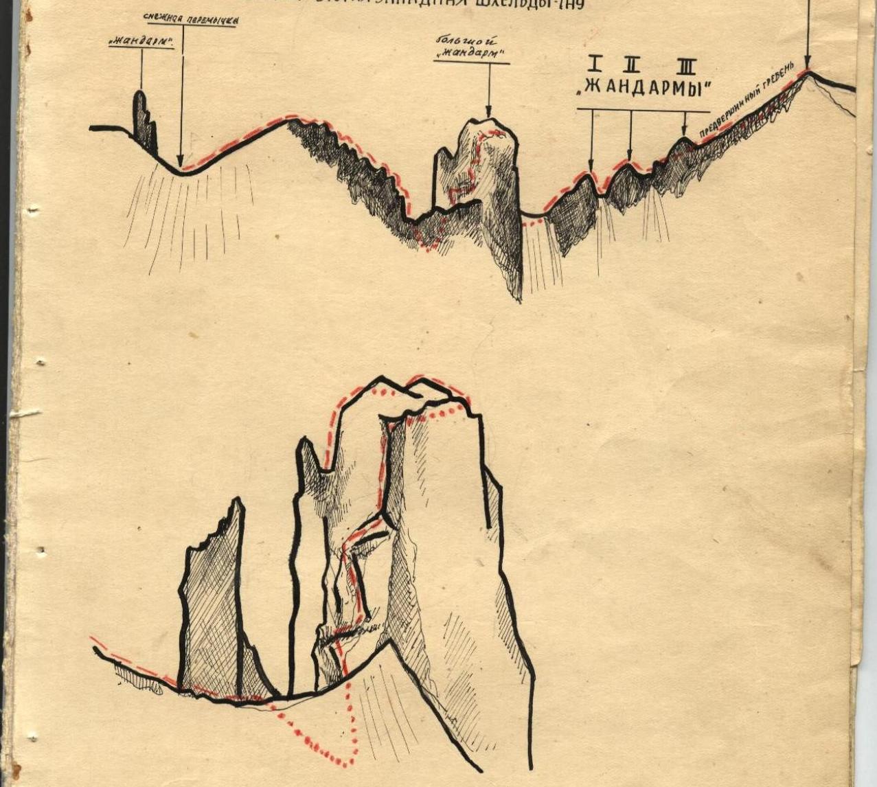
ROUTE OF PASSING THE FIRST LARGE "GENDARME" ON THE "RIDGE OF STROITELLEY" FROM "Dzhil-Ferom" TO THE PASS OF THE RIDGE LEADING TO THE SUMMIT. Two descent options from the summit:
- 2nd Zapadnaya Shkheldy-Tau
- To the Ezhnoshkheldinsky Glacier
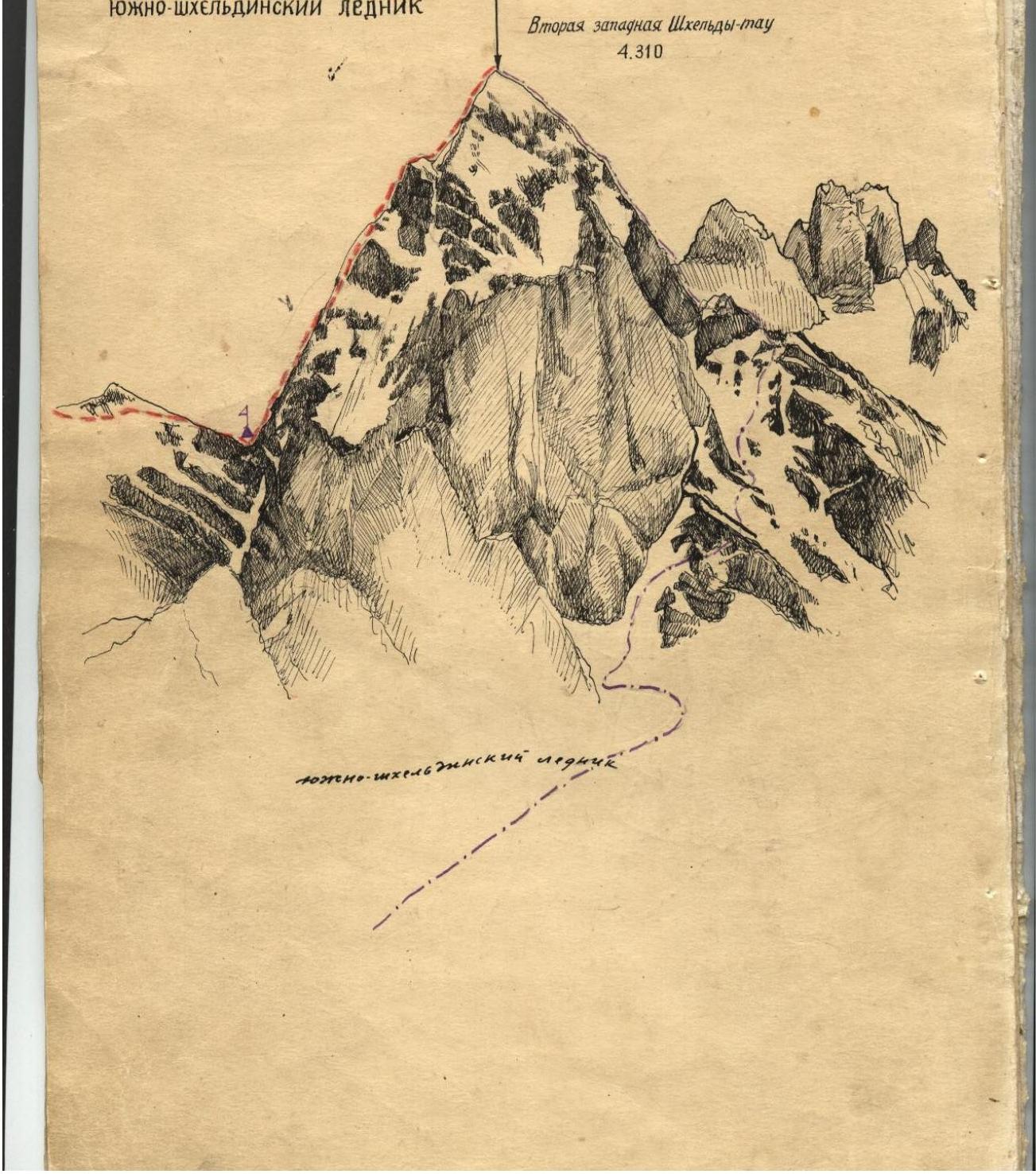
The wall of 2nd Zapadnaya Shkheldy — 770 m