
239
REPORT
On the ascent to Cheget-Kara-Bashi peak via the northwestern counterfort from August 2 to 4, 1972, approximately category 4B difficulty, by a group from the Krasnodar Regional Council of the "Burevestnik" Sports Society.
1. Approach to the Initial Bivouac
From the Dzhatugan alpine camp, follow the road along the Adylsu valley. After 300 m, turn right across the river via a temporary bridge onto the Koshey clearing. Then, follow the trail up to the left-bank moraine of the Kashkatash glacier and along its ridge to a large rock — 1 hour. From here, turn left and ascend via a steep trail to the Turii Lakes — 40 minutes — the location of the initial bivouac.
2. Geographical Information
Cheget-Kara-Bashi — 3667 m — is the outermost peak of the northern spur of Ullu-Kara. To the east of the peak lies the Bashkara glacier, and beneath the western slopes — a small Cheget-Kara glacier with Turii Lake beneath it — a bivouac site.
Several routes to Cheget-Kara-Bashi peak have been established, ranging from category 2B to 4A difficulty. The area around the peak is considered well-explored by climbers; ascent routes are popular among alpine camps in the region. The northwestern counterfort of the peak was first ascended in July 1970 by a group of instructors from the "Elbrus" alpine camp led by N. Korzhov, who rated it category 4B difficulty. This route has become popular among sports groups due to its:
- logical progression,
- safety,
- accessibility.
3. Tactical Ascent Plan
The group planned to depart from the initial bivouac at 4:00 AM to begin work on the rocks by 5:30 AM. With 14 hours of daylight, the group planned to complete the route without a bivouac, but upon consultants' recommendations, they decided to bring:
- a tent,
- a primus stove,
- a pot,
- 2 down sleeping bags,
- 6 down jackets, in case of sudden weather deterioration. Descent to the initial bivouac was planned from 6:00 PM to 7:00 PM. The next day, they would descend to the camp. The control deadline for returning to the "Baksan" alpine camp was August 5, 1972, at 2:00 PM. Radio communication with the camp was maintained using the "Nedra-II" radio station at 7:00 AM and 5:00 PM; emergency listening was at 12:00 PM.
4. Route Description
R0–R1. Departure from the initial bivouac at 4:00 AM. Ascend via grassy fields with numerous streams, then via medium scree to the left-bank moraine of the Cheget-Kara glacier, from where descend onto the glacier above the first icefall and cross it, avoiding crevices, to the base of the northwestern counterfort.
R1–R2. The beginning of the route passes over rocks resembling "ram's foreheads" between R2 and R3, counted from the large couloir. From this point, a 10-meter ledge on the counterfort's ridge is clearly visible, resembling a tooth, with R1 control cairn at its base. Descend into the randkluft and from there, with assistance, ascend 10 meters via difficult rocks to the "ram's foreheads." Further:
- ascend 30 meters via steep "ram's foreheads" to a grassy ledge,
- leftward via rocks with flowstone 40 meters to a snowy shelf.
From here, through a 3-meter wall — exit to the left side of an 8-meter snowy slab and along it — to a rocky ascent (70°) onto a saddle beneath the "tooth." Here:
- R1 control cairn,
- a possible bivouac site.
12 rock pitons were hammered on this section, with alternating belays, taking 2 hours.
R2–R3. From R1 cairn, 30 meters up along the ridge to a sheer ascent and rightward, bypassing the ascent, via a narrow, sloping 10-meter ledge to its end. Further, descend 4 meters down to a convenient snowy shelf, from where exit onto the ridge first via a 7-meter internal corner, then via medium rocks. Along the ridge 40 meters with simultaneous belays and to the left side via medium rocks approach beneath the "black rock" — the route's key location. 4 rock pitons were hammered on this section, with simultaneous belays, taking 1 hour.
R3–R4. From the belay point:
- via a 3-meter slab to the base of a narrow 5-meter chimney;
- up the chimney to a hanging plug — difficult climbing;
- bypass the plug rightward via a slab;
- ascend via a 2-meter fissure to a shelf.
Further, leaving large live rock blocks to the left, ascend:
- via a smooth 7-meter internal corner to a narrow ledge — very difficult climbing;
- along the ledge leftward;
- then ascend via a sheer, fractured wall to a bend.
Here is a belay point. On this section, backpacks were pulled up; perches and ladders were used for passage. 11 rock pitons were hammered, 4 of which were for creating artificial holds, taking 3 hours.
R4–R5. From here, via a ledge with a "knife," exit onto the ridge to R2 control cairn — a possible bivouac site. Along the ridge 60–70 meters with simultaneous belays to R1 gendarme. On this section, belays were conducted via ledges, taking 1 hour.
R5–R6. Bypass R1 gendarme on the left via medium rocks, further along the ridge 15 meters and leftward, bypassing R2 gendarme along the snow edge to exit onto the ridge. From the ridge, rightward onto destroyed ledges — 15 meters — and further along a simple ridge 60–80 meters to R3 gendarme. Bypass R3 gendarme on the left along the snow edge to an ice slope with a thin snow layer. Along the ice-rock boundary, ascend to a sharp ice ridge and along it — to the wall of R4 gendarme. On this section, movement was simultaneous, taking 1 hour.
R6–R7. From the crest, traverse the base of the wall via a 10-meter indistinct ledge to a black triangular patch and from it via a 5-meter slit leftward-upward to a rib. Further via snowy rocks rightward-upward to the ridge. 10 pitons were hammered, taking 1 hour 30 minutes.
R7–R8. Along the ridge 15 meters to the base of R5 gendarme. From here:
- ascend 8 meters via medium rocks,
- then leftward 6 meters via slabs to a narrow ice couloir.
R8–R9. Cross it in the lower part and via the left wall ascend 10 meters to a snowy ledge. Along the ledge leftward to a rocky outcrop and via it 8 meters of difficult climbing, leading to medium rocks, along which 20 meters to a snowy patch. Cross the patch leftward-upward and exit onto the edge of the gendarme, further 5 meters descend to a snowy ledge and along it 20 meters to the shoulder of the gendarme. From the shoulder, a 25-meter rappel via a rope in a sports manner to the snow at the gendarme's wall. For rope retrieval, a 40-meter auxiliary rope was used. Along the snow edge, ascend leftward to a saddle beneath the wall of the subpeak. On this section, 7 pitons were hammered, 2 of which were for the rappel, taking 2 hours 30 minutes.
R9–R10. Ascent up the subpeak's wall begins with a vertical 6-meter internal corner with live rocks, leading to a sloping ledge, which is traversed rightward to a convenient exit onto medium, destroyed rocks. Further via these rocks, ascend directly near the ridge line 50–60 meters to R3 control cairn.
Here, the group set up a bivouac due to deteriorating weather — strong wind, snow. 4 pitons were hammered, taking 1 hour.
R10–R11. Departed the bivouac at 7:00 AM, with good weather. From the subpeak, along a horizontal snowy ridge 80–100 meters, approach the left part of the summit tower and ascend via steep snow to a pronounced internal corner, then via its left wall with a fissure to a good ledge, along which 30–40 meters to the summit. Taking 30 minutes.
Descent began via medium rocks on the 2B category difficulty route. Further, three times organized rappel descents via rope to a saddle with Gergogenova peak. From here, via a couloir and across the glacier to the initial bivouac. Descent concluded at 10:30 AM.
The traversed route via the northwestern counterfort to Cheget-Kara-Bashi peak is an interesting combined route. It is safe and logical, filled with complex sections. The route's length is 1300 meters, including 250 meters of the most difficult sections with steepness of 70–75° and 90°.
Comparing this route to previously traversed category 4 difficulty routes, the group believes that in terms of terrain complexity and steepness, the traversed path surpasses routes such as:
- MNR peak northern 4A category difficulty,
- Kardyvach peak 4A category difficulty, and is on par with 4B category difficulty routes on MNR central "Domбай-Ulgen" peak.
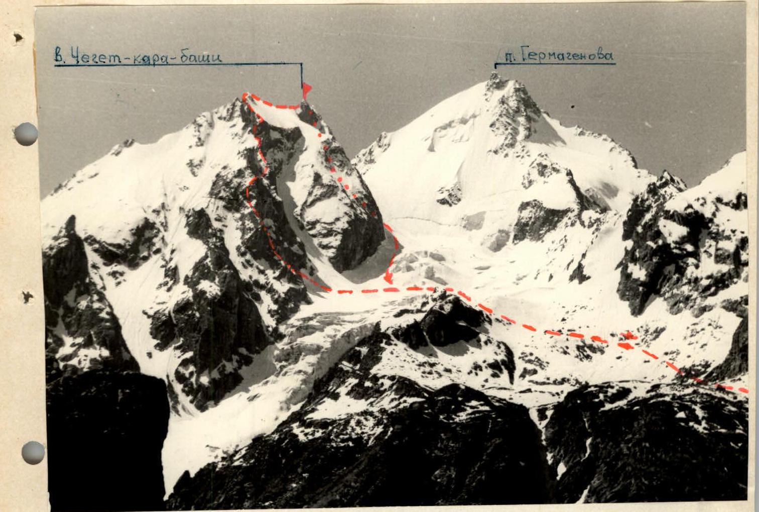
General view of the peak from the Dzhan-Tugan rock laboratory.
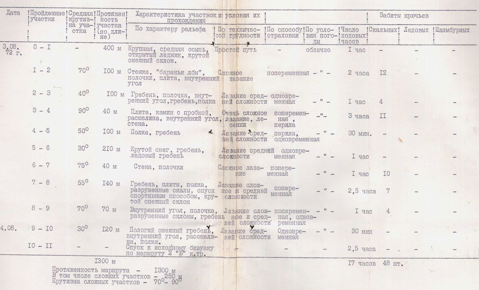
Table of Main Characteristics of the Ascent Route to Cheget-Kara-Bashi Peak via the Northwestern Counterfort
| Date | Sections Covered | Average Steepness on Section | Section Length (by Length) | Characteristics of Sections and Conditions of Passage | Pitons Hammered |
|---|---|---|---|---|---|
| By Terrain Character | By Technical Difficulty | ||||
| 03.08.1972 г. | R0–R1 | 400 м | Large, medium scree, open glacier, steep snow slope. | Simple path | |
| R1–R2 | 70° | 100 м | Wall, "ram's foreheads," ledges, slab, internal corner. | Complex climbing | |
| R2–R3 | 40° | 100 м | Ridge, ledge, internal corner, ridge, shelf. | Climbing of medium complexity | |
| R3–R4 | 90° | 40 м | Slab, chimney with plug, fissure, internal corner, wall. | Very complex climbing, ladders | |
| R4–R5 | 50° | 100 м | Ledge, ridge. | Climbing of medium complexity | |
| R5–R6 | 30° | 210 м | Steep snow, ridge, ice ridge. | Climbing of medium complexity | |
| R6–R7 | 75° | 40 м | Wall, ledges. | Complex climbing | |
| R7–R8 | 55° | 140 м | Ridge, slabs, ledge, destroyed rocks, sports-style descent, steep snow slope. | Complex and medium complexity climbing | |
| R8–R9 | 70° | 70 м | Internal corner, ledge, destroyed slopes, ridge. | Complex and medium complexity climbing | |
| 04.08.1972 г. | R9–R10 | 30° | 120 м | Gentle snow ridge, internal corner, fissure, ledges. | Climbing of medium complexity |
| R10–R11 | Descent to initial bivouac via 2B category difficulty route. | ||||
| Total: | 1300 м | Route length — 1300 м. Including complex sections — 250 м. Steepness of complex sections — 70–90°. |
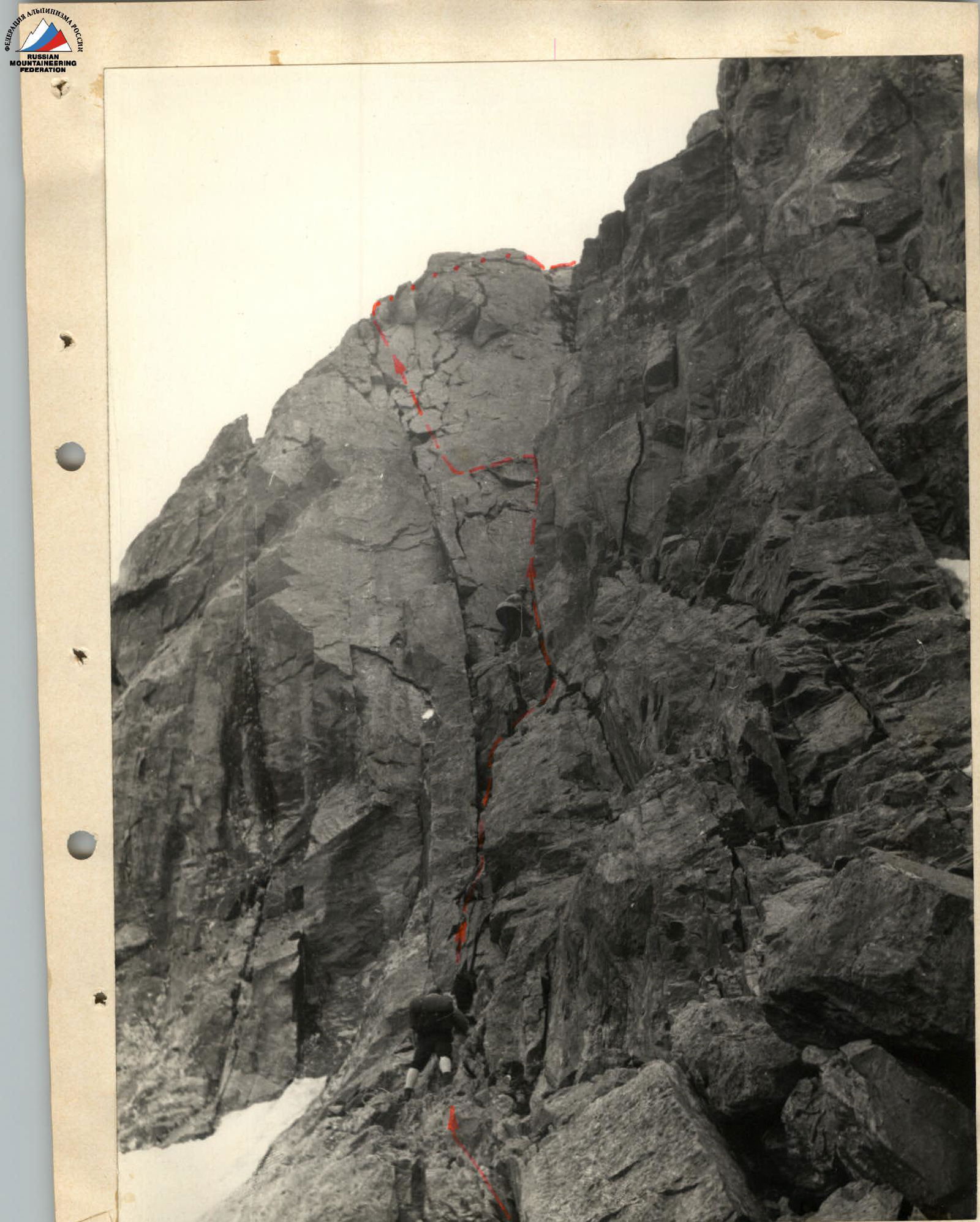
Key section of the route [2-3].
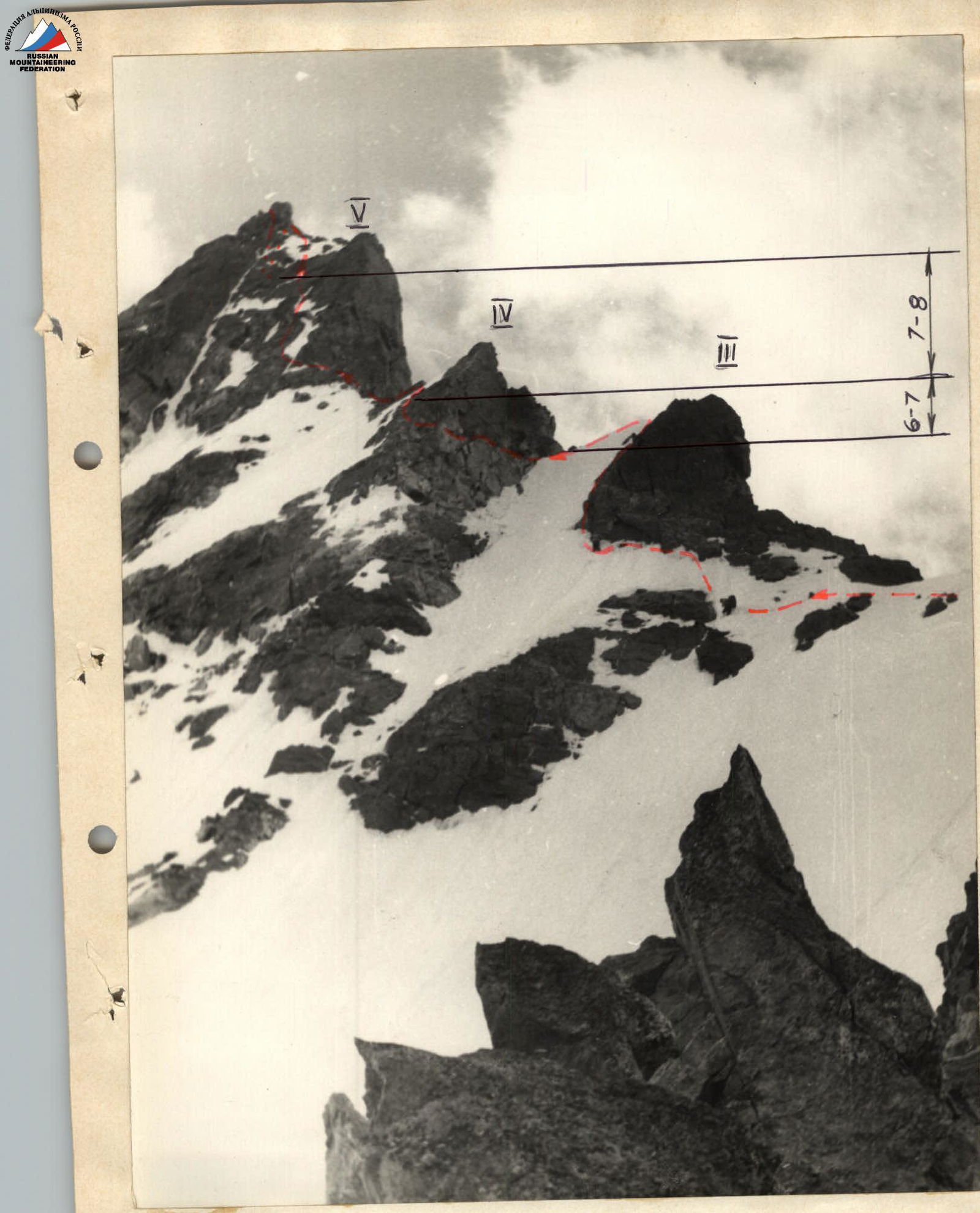
Ridge to the subpeak.