2286
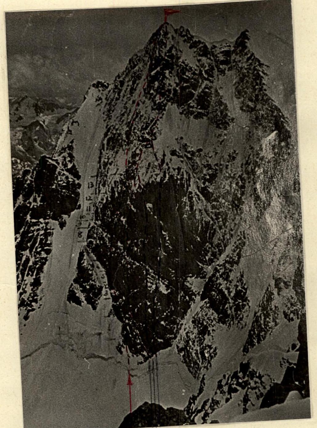
V. CHATYN-TAU (4363 m). ROUTES ON THE "DIAMOND":
- PRIMITIVE ROUTE
- SNESAREV'S ROUTE
- CHERNOSLIVIN'S ROUTE
- MYSHLYAEV'S ROUTE
PASSING SECTION II, AS WELL AS SECTIONS 5, 6, 7, 8, 9, 11, 12, 13, 16 ON THE "DIAMOND" (170 meters)

Team Composition
Bolzhevsky Valery Konstantinovich, Master of Sports of the USSR, engaged in mountaineering since 1957, born in 1990, Russian, non-party.
Grigorenko-Prigoda Yuri Ivanovich, Master of Sports of the USSR, engaged in mountaineering since 1956, born in 1935, Ukrainian, non-party.
Shumikhin Vladimir Sergeevich, Candidate Master of Sports of the USSR, engaged in mountaineering since 1960, born in 1938, Russian, non-party.
Route Description
From the "Baksan" alpine camp by car to the "Shkhelda" alpine camp, then through the Shkhelda gorge to the "German" overnight stays (6 hours), and to the Lozhny Chatyn pass (40 minutes). Through the Lozhny Chatyn pass - under the northern wall of Chatyn-Tau peak (2 hours).
Under the "diamond" of the northern wall is a snowy plateau where a camp can be organized; you can also stop on the rocks when descending from the pass to the plateau.
On the "diamond" of the northern wall, three routes were previously laid (all 6B category of difficulty):
- All routes start to the right of the base of the "diamond", where Snesarev's route eaves converge.
- 30 meters to the right - Myshlyaev's route chimney.
Our route starts at the lowest part of the base of the "diamond", a landmark for the start of the route are rock islands under Snesarev's shelf. The bergschrund is overcome using screwed-in hooks and ladders. A 40-meter slope with a steepness of 40-50° leads to the rocky island, the complexity of overcoming it lies in the fact that it is a layered firn, crampons hold poorly, and for hammering in hooks, careful processing of the slope is required (attention! Ice stones are flying from the wall, it's necessary to overcome it - either early in the morning or late in the evening). The rocky island is passed on the right side, the rocks are steep and heavily destroyed (large-sized hooks are used).
After passing the island, movement goes along the couloir (this is not Garfovsky couloir), it is not possible to move along the couloir as it is very steep (in the upper part up to 85°) and very prone to rockfall, above it at a height of 300-400 m is a mulde above the bend of the "diamond". The rocks along the couloir are continuous slabs with a small number of holds, steepness 80-90° (the rocks are more complicated than on Snesarev's shelf and immediately after it). When moving along the couloir, it is necessary to watch the top - stones fly mainly through the heads, as the movement goes under a steep wall. Along the couloir, you need to move 130 m to a safe place under a rocky cornice, until this point the movement was along the I rock belt.
The entire "diamond" is cut by a rock shelf into two rock belts. Overcoming the I belt is a movement along cornices. The first large cornice is overcome on the left, to get to it, you need to overcome 4 cornices of 10-15 m, all movement occurs only on artificial support points (various hooks: regular ice hooks, metal wedges, wooden wedges, and 2 piton hooks). At the exit to the main cornice, there is a convenient site for people and backpacks. The rope thrown from the main cornice throughout its entire length (50 m) lags behind the wall: at the lower site (two people can stand) - by 2 m, and in the middle part - up to 4-5 m. Under the cornice, you can organize a bivouac - a safe place (in hammocks).
After passing the cornice, it is necessary to make a traverse to the right along the shelf, along which you can walk with your feet or hands. The traverse is made to the end of the shelf (30 m), the rocks have a steepness of 90° or more, and the shelf is a depression in the wall. On the shelf, you can accommodate in hammocks - a safe place. From the end of the shelf, movement is straight up and slightly to the right to the base of the chimney. The section is overcome on artificial support points, the steepness of the rocks is more than 90°. At the base of the chimney, there is a site under the cover of rocks where 2 people can stand, and you can organize a reception of backpacks. The ascent continues on its left side (35 m) on artificial support points. The passage of the chimney ends with a complex section of the rock belt. Rocks leading to the base of the II rock belt are overcome by regular climbing (30 m). There are no sites for overnight stays, but at the base of the II belt, you can find a safe place to organize a bivouac.
The II rock belt is overcome along the wall. The first 30 m of rocks are false, steep, but overcome by regular climbing along the inner corner in the direction of the flake to the left and up, and then 60 m - with the use of artificial support points - to the right and up to the base of the bastion of the mulde on the bend of the "diamond". The main complexity of the route on the northern wall of Chatyn-Tau peak lies in overcoming the "diamond" - the steepest part of the route. 7 working days (80 working hours) were spent on passing the "diamond", and after the "diamond" to the summit, the group passed in 1 working day. From the bend of the "diamond", the main part of the equipment can be dropped onto the plateau under the wall (a dropped backpack flies 300 m without touching the wall). The mulde after the bend is overcome on crampons with the use of screwed-in ice hooks for insurance. After passing the mulde, movement goes straight up to the ridge of the summit with an exit to the left of the summit, the rocks are местами heavily destroyed, there are short steep sections up to 85°. 50 m from the Main summit of Chatyn-Tau towards the Western summit, there is a site for a tent. Descent from the summit to the Uzhbinsky plateau along the route 3A category of difficulty through the Western summit along the ridge, insurance - through ice hooks. Return to the camp through the Uzhbinsky icefall.
Route Schedule by Days
July 20, 1969, the group from the "Baksan" alpine camp led by Bolizhevsky V.K. went under the wall of Chatyn-Tau peak.
- July 21-27 - equipment throws under the wall, observation of the route, and days of bad weather.
- 1st day, July 28 - processing the start of the route, from 3:00 to 21:00 (18 hours) to the I rock belt, sections R1-R4.
- July 29-31 - days of bad weather, the group was under the wall.
- 2nd day, August 1 - passage of the I rock belt, sections R5-R8.
- 3rd day, August 2 - passage of sections R9 and R10.
- 4th day, August 3 - passage of sections R11 and R12.
- 5th day, August 4 - passage of sections R13 and R14 under the rocks of the II belt. Due to the onset of bad weather, the group descended from the route, leaving the ropes on the passed section of the wall, and returned to the "Baksan" alpine camp.
- August 9 - the group went on the route consisting of: Bolizhevsky V.K. - leader; Grigorenko-Prigoda Yu.I.; Shumikhin V.S.
- August 10 - the group went under the wall of Chatyn-Tau.
- 6th day, August 11 - passage of sections R1-R10, organization of a bivouac.
- 7th day, August 12 - passage of sections R11-R14, organization of a bivouac, processing of the II rock belt and the bend.
- 8th day, August 13 - passage of the counterfort after the bend of the "diamond", exit to the summit of Chatyn-Tau.
- 9th day, August 14 - descent from the summit and return to the alpine camp.
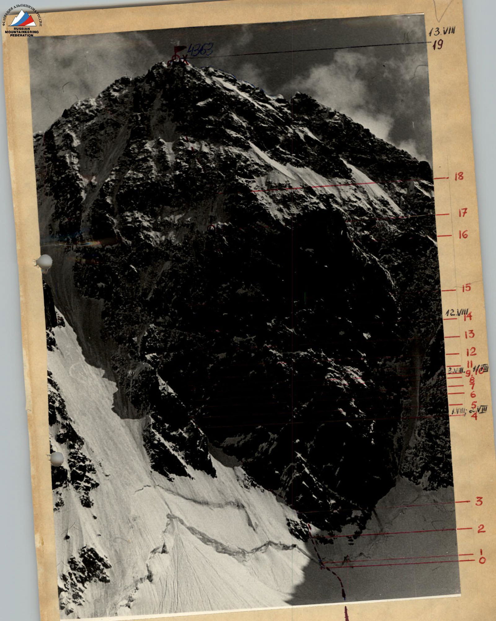
Route breakdown by sections
X - overnight stay locations
○ - control tours
Main Characteristics of the Route
The ascent route - Chatyn-Tau, northern wall, "diamond" to the left of Snesarev's route. Height difference - 1000 m (slightly less). Route length - 1100 m. Average steepness of the route - 80-90°. The most difficult sections - "diamond" - 500 m, of which very difficult - 170 m, overcome on artificial support points. Hooks hammered - 407. Including: rock - 261, ice - 146 (of which in rocks - 85), wedges - 14, piton hooks - 2.
Protocol for Reviewing the Ascent to Chatyn-Tau Peak via the "Diamond" (left of Snesarev's route), approximately 6B category of difficulty.
August 15, 1953.
Present:
Authorized representative of the Alpinism Federation Yu.I. Antonovich
Group:
- Bolizhevsky V.K. - leader
- Grigorenko-Prigoda Yu.I. - participant
- Shumikhin V.S.
BOLIZHEVSKY V.K. - Detailed report on the passage of the bergschrund - 8 ice hooks. 40-meter ice slope, steepness 40° - 8 ice hooks, 3 rock hooks. 50-meter rocky island, steepness 70-75° - 3 ice hooks, 14 rock hooks.
Further movement along the couloir along the rocks 130 m, steepness 80-90° - 6 ice hooks, 34 rock hooks. The I rock belt is of particular difficulty, has five cornices, a total length of 190 m, passed with the use of artificial support points. Hooks hammered: ice - 35 (in rocks due to their great destruction), rock - 106, wedges - 9, and piton hooks - 2.
The II rock belt - total length 100 m, of which very difficult - 70 m. Hooks hammered: ice in rocks - 22, rock - 59.
Mulde - length 100 m, ice hooks hammered - 30, and 4 rock hooks when exiting to the rocks.
The ridge to the summit is a route of approximately 5B category of difficulty. Passed without much tension in one day without pulling out backpacks.
Antonovich: - Tell us about the tactical plan.
Bolzhevsky: - In the lower part of the route, ropes hung by Yuri Bolizhevsky's group were used.
August 10 - left the "Baksan" alpine camp, approached the wall.
August 11 - passed the previously processed section to the shelf on the I rocky island.
August 12 - passed to the end of the chimney, organized a bivouac, and began processing the II rock belt.
August 13 - passed the processed section, exited beyond the bend of the "diamond"; passed the bend and the mulde and along the ridge at 18:00 climbed to the summit. Spent the night on the ridge 70 m from the summit in the direction of descent 3A category of difficulty. Had everything necessary for a normal rest.
August 14 - descended from the summit and further to the camp. Arrived at the camp at 16:00.
Antonovich: - Which group is better to go with: three or four people?
Bolzhevsky: - For a "three", there is more load due to the weight of the equipment. The rapid progress of the group is not attributed to the number of participants, but to the previously processed sections.
Antonovich: - What unpleasantness happened?
Grigorenko-Prigoda: - August 11 - heavy rain from the wall. August 13, the second half of the day, the weather began to deteriorate, August 14 - dense fog, occasional snow.
Bolzhevsky: - It should be noted: the I rock belt - rocks are hazardous, heavily destroyed.
Antonovich: - How was it with hot meals? Did you save time?
Bolzhevsky: - The food was good: the group had a "Febus" primus stove, 3 liters of gasoline, a pot, and a sufficient supply of food.
Grigorenko-Prigoda: - Saved 2 days in time.
Antonovich: - Does this route deserve the 6B category of difficulty? Which section deserves the 6B category of difficulty, its length?
Grigorenko-Prigoda: - I have 8 summits of 5B category of difficulty, 4 of which are first ascents. This route deserves the 6B category of difficulty. The height difference is about 1000 m, of which 507 m are difficult rocks, 200 m were passed on artificial support points.