PASSPORT
I. Technical category 2. Central Caucasus, Elbrus region 3. Chatyn Glavny peak via the bastion of the Eastern wall 4. Assumed 5B category of complexity, first ascent. 5. Elevation gain 1950 m, length — 3250 m. Length of sections with 5B-6 category of complexity — 640 m. Average steepness of the main sections: bastion 70° (3592–4060), buttress 59° (3216–3592), including 6 category sections: 252 m (3320–3380), (3742–3780), (3815–3855), (3987–4045). 6. Pitons driven: rock 73/0; bolt pitons — 2/2; chocks 163/0; ice screws 34/0. 7. Team's travel time 33 hours and days — 2.5. 8. Night halts: 1st on a rock shelf, 2nd on a snow platform. 9. Team leader: Galkin Sergey Petrovich, Master of Sports of the USSR Team members:
- Zhuravlev Viktor Vasilievich, Candidate Master of Sports
- Fedkov Alexander Viniaminovich, Candidate Master of Sports
- Pustolyakov Alexander Borisovich, Candidate Master of Sports
- Coach: Stavnitser Alexey Mikhailovich, Master of Sports of the USSR
- Approach to the route: August 3, 1986. Reached the summit: August 5, 1986. Return to the camp: August 5, 1986.
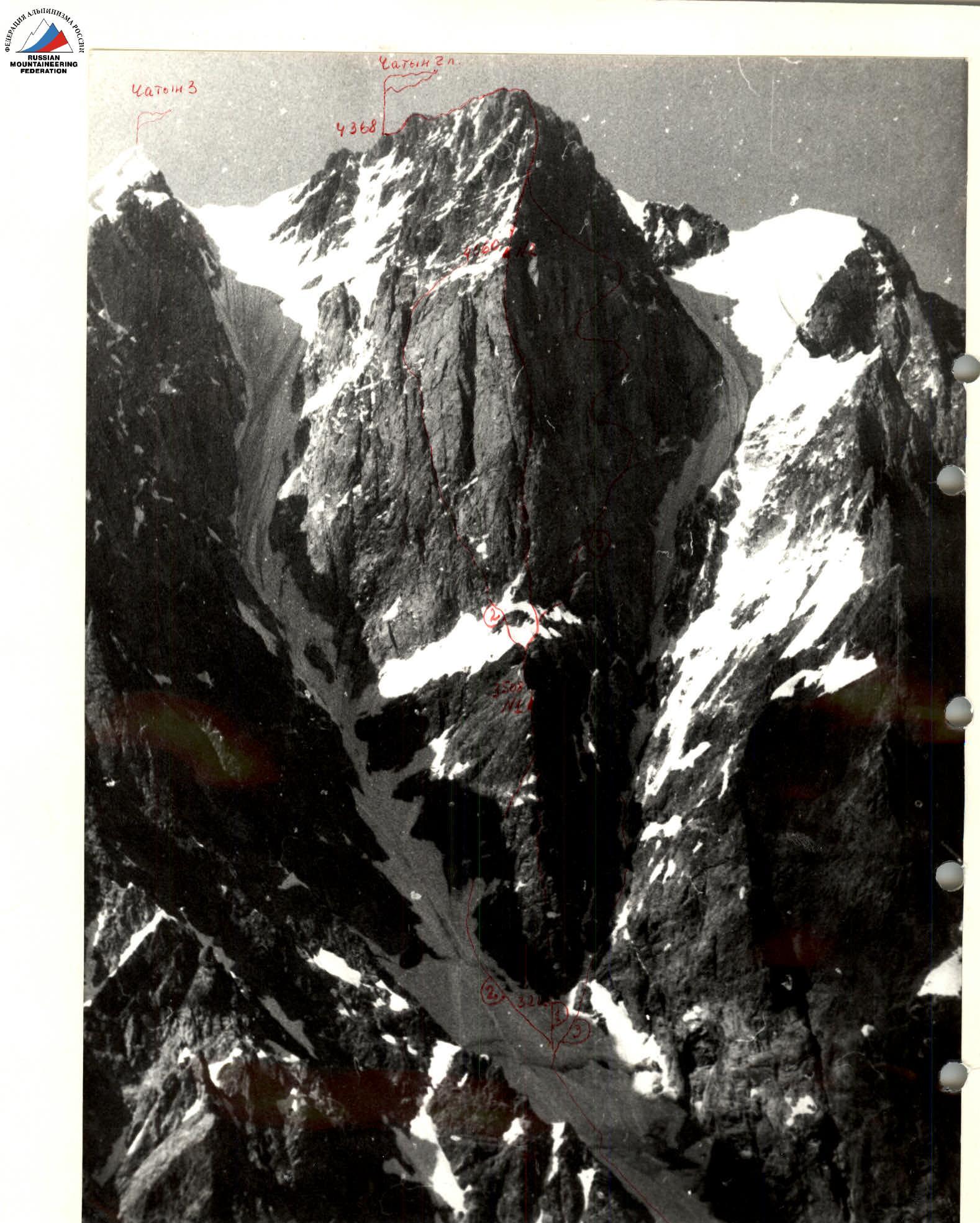
Photo # 1. 1 — route climbed by the "Shkhelda" team in 1986. Date taken August 3, 1986. Time taken 16:00. Camera "Zenit", lens "Yupiter"; F=135 mm. # 2 — location of the shot on the map. Height of the shot 3160 m. Distance to the object 3 km. 2 — Mirianashvili's route 1961. 3 — Giuatavashvili's route 1965.

Photo # 2. Profile of the left wall. Date taken August 4, 1986. Time taken 16:00. Camera "Zenit E", lens "Yupiter"; E=135 mm. # 1 — location of the shot on the map. Height of the shot 3050 m. Distance to the object 3 km.

Photo # 3. Profile of the right wall. Taken from V. Uprukara. Lens F-135 mm.
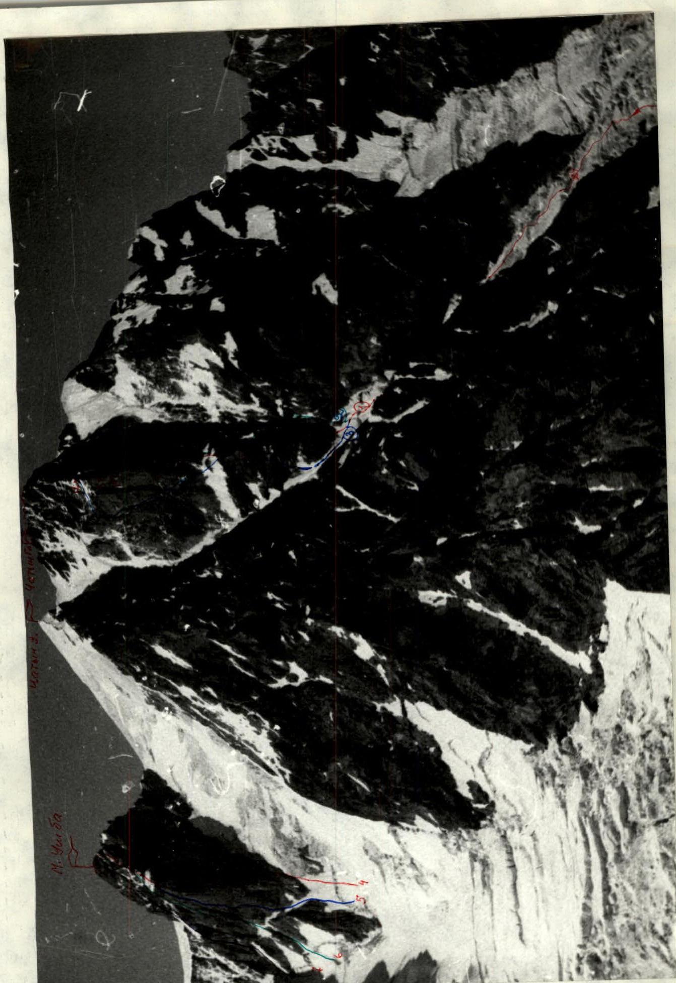
Photo # 4. Panoramic photo of the area. Date taken August 4, 1986. Time taken 16:00. Camera "Zenit", lens "Yupiter"; E=135 mm. # 3 — location of the shot. Distance to the object 3.5 km. Height 3200 m.
- "Shkhelda" route 86
- Giuatavashvili's route 65
- Mirianashvili's route 61
- Kensitsky's route 71
- Gorodetsky's route 77
- Grigorenko-Prigoda's route 81
- Kudryavtsev's route 85
Brief Overview of the Ascent Area
The Chatyn Glavny peak is located in the Main Caucasian Range. The Chatyn massif has two peaks: Western and Main. The Eastern wall of Chatyn Glavny faces Svaneti. The approaches to this wall are laborious and lengthy. From the Baksan valley, several paths can be taken to approach the route:
- Through the Ushba glacier, Chalaat pass between Chatyn and Ushba or Malaya Ushba and Severnya Ushba. Descent via the glacier takes 7-9 hours, then along the right branch of the Chalaat glacier to the bivouac site for observation — 17 travel hours from the "Shkhelda" base camp. The approach is complex and hazardous.
- Through the Lzhny Chatyn pass, followed by a descent via three steps of the Chalaat glacier's left branch, which circumvent the eastern ridge of Chatyn peak, 14-16 travel hours. Passage through the three steps of the glacier is very hazardous and technically challenging.
- Through the Becho pass, Mazeri village, Gulpari village, Gulba pass or Gul pass, followed by a descent to the Chalaat glacier and along it to the observers' bivouac — 20 travel hours. The path is safe but very long and tiring. The "Shkhelda" team followed this path.
- Another approach path exists — from Mestia along the Lekzyr glacier to the Chalaat glacier and through the glacier's icefall, crossing the right branch, ascent to the observers' bivouac — 10-12 travel hours. From Mestia without significant elevation gain, but crossing the icefall presents certain difficulties and hazards. "Chatyn from Svaneti" is a rarely visited climbing destination. The classifier notes two routes from the Svaneti side: 5B via the 10th category, without the year of ascent or team leader's name; 5B via the 10-V category, R. Giuatavashvili, without the year of ascent.
In A.F. Naumov's book "Mountains of Svaneti", Moscow, "Fizkultura i Sport" publishing house, 1985, routes #232 and #233 describe 5B category ascents to Chatyn peak from the Chalaat glacier side.
Route #232 — Chatyn via the Eastern wall of the southern ridge (combined route, team leader R. Giuatavashvili; B. Tvarliani, Sh. Margiani, D. Galustashvili, I. Khergiani completed the ascent August 3-7, 1965).
The second ascent was made by A. Ermanov's team; I. Bandurovsky, G. Medved, Yu. Tetinin August 7-15, 1966. This route is significantly to the right of the route taken by the "Shkhelda" team.
Route #233 — Chatyn via the Western wall of the broad ridge (combined route, team leader Sh. Mirianashvili; I. Kavlashvili, G. Managadze, V. Tevdorashvili, S. Khabeishvili completed the ascent August 2-16, 1961).
This route is significantly to the left of the route taken by the "Shkhelda" team on August 3-5, 1986.
Team's Tactical Actions
Throughout the ascent, no prior route processing was conducted. The first rope team changed daily, with leaders in the teams changing more frequently. The first team's task included organizing and securing the rope route. For faster and more reliable progress, the first climber worked without a backpack and in galoshes.
The second team carried the main load and transferred equipment using special loops from the fourth to the first climber. All participants worked on a double rope. The first climber used an амортизатop (shock absorber) with lower belay, while the rest followed the fixed ropes with two jumar clamps and upper belay. Fixed ropes were established throughout the wall section of the route.
Throughout the ascent, the team had two hot meals a day, as well as pocket food during the working day. A bivouac on the route was set up in a tent on a platform.
Regular communication was maintained with observers, and through them with the "Shkhelda" base camp. Additionally, observers could see the team through a telescope for most of the ascent, except for the icefall section.
There were no falls or injuries. The ascent was completed in full accordance with the tactical plan.
Fixed ropes were set up on sections R1-R2; R3-R27. All types of modern equipment were used for these sections: ice screws, pitons, chocks, friends, амортизатop, jumar clamps, rock pitons, and 2 bolt pitons.
Leaders changed on sections: R1-R2; R2-R3; R3, R13, R19, R25.
Photo numbers: #6, #7, #13, #14, #12, #11, #10.
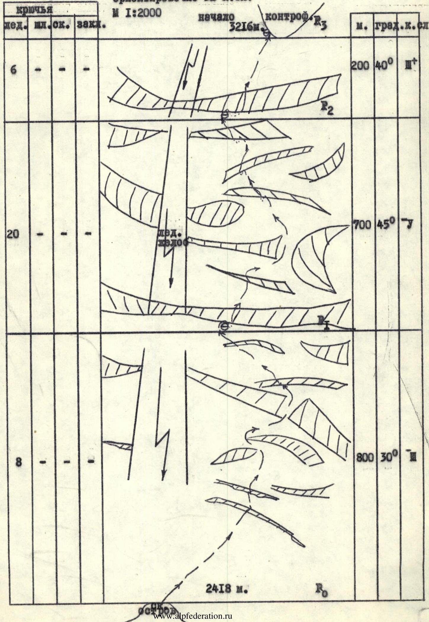
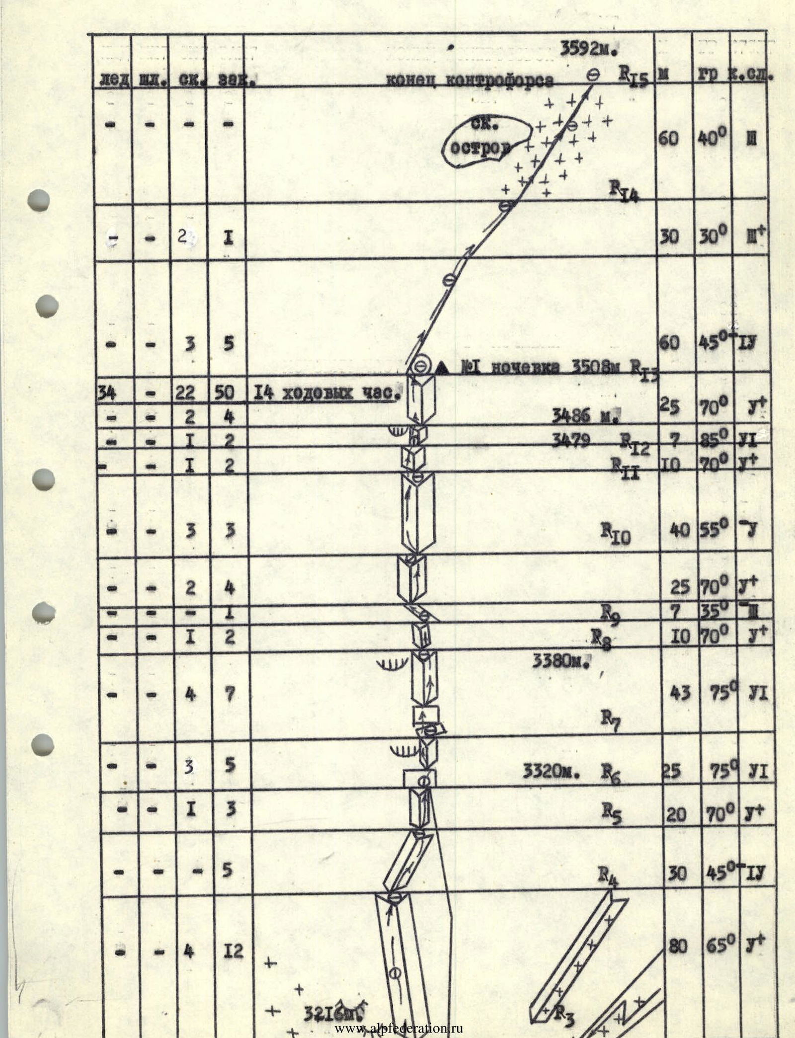
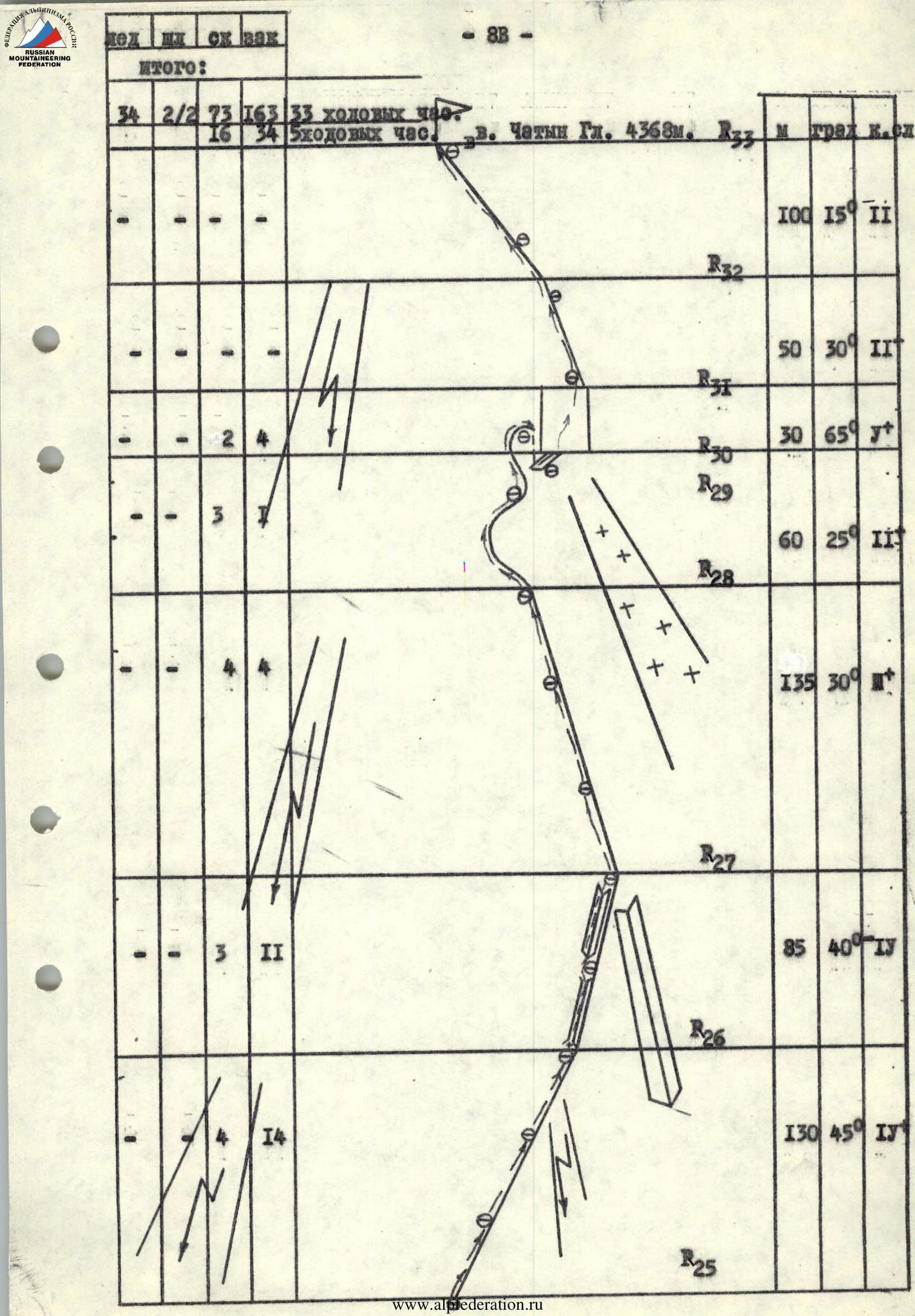
Route diagram in UIAA symbols. First ascent on Chatyn Glavny peak via the bastion of the Eastern wall, approximately 5B category.
Start of the buttress R3, 3216 m.
| Section | Ice screws | Bolt pitons | Rock pitons | Chocks | Length, m | Steepness, ° | Category | Remarks |
|---|---|---|---|---|---|---|---|---|
| R0–R1 | 6 | - | - | - | 2000 | 40 | 1 | |
| R1–R2 | 20 | - | - | - | 700 | 45 | - | |
| R2–R3 | 8 | - | - | - | 800 | 30 | 1 | |
| R3–R4 | - | 2 | - | 2 | 30 | 30 | 2+ | |
| R4–R5 | - | - | 3 | 5 | 60 | 45 | 4 | |
| R5–R6 | - | - | 1 | 3 | 20 | 70 | 5+ | |
| R6–R7 | - | - | 4 | 12 | 80 | 65 | 5+ | 3320 m |
| R7–R8 | - | - | 3 | 5 | 25 | 75 | 5+ | |
| R8–R9 | - | - | 1 | 3 | 20 | 70 | 5+ | 3380 m |
| R9–R10 | - | - | 2 | 4 | 25 | 70 | 5+ | |
| R10–R11 | - | - | 3 | 3 | 40 | 55 | 5 | |
| R11–R12 | - | - | 1 | 2 | 10 | 70 | 5+ | |
| R12–R13 | - | - | 1 | 2 | 7 | 85 | 6 | 3479 m, 3486 m, 1st bivouac 3508 m |
| R13–R14 | - | - | 2 | 4 | 25 | 70 | 5+ | |
| R14–R15 | - | - | - | - | 60 | 40 | 2 | End of buttress R15, 3592 m. |
| R15–R16 | - | - | 3 | 9 | 80 | 60 | 5 | |
| R16–R17 | - | - | 6 | 13 | 80 | 75 | 5+ | |
| R17–R18 | - | - | 2 | 5 | 40 | 65 | 5+ | |
| R18–R19 | - | - | 3 | 8 | 45 | 80 | 6 | 3777 m, 3820 m, CTL |
| R19–R20 | - | - | 2 | 5 | 43 | 65 | 5+ | |
| R20–R21 | - | - | 4 | 8 | 45 | 80 | 6 | 3855 m |
| R21–R22 | - | - | 3 | 7 | 45 | 65 | 5+ | 3900 m |
| R22–R23 | - | 2 | - | 2 | 7 | 70 | 6-10 | |
| R23–R24 | - | - | 3 | 9 | 45 | 75 | 5+ | 3987 m |
| R24–R25 | - | - | 1 | 2 | 10 | 85 | 6 | 4045 m, End of bastion R25, 4060 m |
| R25–R26 | - | - | 4 | 14 | 130 | 45 | 4 | |
| R26–R27 | - | - | 3 | 11 | 85 | 40 | 4 | |
| R27–R28 | - | - | 4 | 4 | 135 | 30 | 2+ | |
| R28–R29 | - | - | 3 | 7 | 60 | 25 | 2 | Rappelling 25 m |
| R29–R30 | - | 2 | - | 4 | 30 | 65 | 5+ | |
| R30–R31 | - | - | - | - | 50 | 30 | 2 | |
| R31–R32 | - | - | - | - | 100 | 15 | 2 | |
| R32–R33 | - | - | - | - | - | - | - | Chatyn Glavny peak, 4368 m |
| Total | 34 | 2/2 | 73 | 163 | 33 travel hours |
Route Description by Sections
The route begins at a characteristic rock outcrop in the middle left part of the icefall.
Section 0-1. Movement up the icefall to the right, avoiding numerous crevasses. It's necessary to move quickly to avoid being in the left part of the icefall during rockfall and avalanches.
1-2. The icefall's steepness increases sharply, surrounded by countless crevasses. We attempt to bypass some crevasses, jump over others, and climb through the rest. A massive crevasse blocks the path across the entire width of the icefall. We rappel 10 m down, as the crevasse's bottom is filled with snow and ice debris, and climb up the sheer wall. Ahead, more smaller crevasses; passage through them leads to a more tranquil section.
2-3. Movement continues in the right part of the glacier, which is less hazardous. The number of crevasses decreases, but another large crevasse spans the entire width of the icefall. With great effort, we overcome it and approach the buttress.
3-4. Slightly left of the buttress's midpoint, a steep and lengthy internal corner is visible. Movement up its left side requires high technique; at the top, there's a convenient ledge for a halt. The internal corner is formed by a branched, large-block structure of gray granite.
4-5. Up the inclined internal corner to the right, under the base of a steep internal corner.
5-6. Monolithic rocks with few cracks; exit to the right under a wall with a crack leading upwards, belay in a hang.
6-7. Monolithic wall with holds facing the opposite direction and the possibility of belaying via a single crack. Exit via this crack under a cornice and bypass it on the right through a very steep internal corner. The left side is more accessible, with cracks. The internal corner ends on a convenient ledge where the team can gather.
7-8. Further, through a sheer wall into an internal corner, exit on its right side, bypassing the cornice, onto a ledge. The walls of the internal corner are monolithic with limited holds and few cracks for belaying.
8-9. From the ledge, straight up the right part of the internal corner, exit onto an inclined ledge. Here, the team can gather and relax.
9-10. Along the inclined ledge — cautiously, as there are "live" rocks — move left upwards to an internal corner. Difficult climbing on the right side of a steep section to a small ledge.
10-11. From here, along a not very steep internal corner, move left to a ledge at the top of the internal corner.
11-12. Further, along the left side of a steep internal corner, under the base of an even more complex section, belay in a hang.
12-13. Climbing the left side of the internal corner with minimal holds and cracks to a less complex section, and exit onto the buttress ridge. Here, there's a possibility to set up a tent on a platform.
13-14. Along the sharp ridge with belay through ledges and chocks, exit to a snowfield under the bastion.
14-15. Movement along the snow leads to the start of the bastion. The bastion is represented by a steeply sloping junction of two walls, Southern and Eastern. The route passes to the right of this junction and exits onto it at the top. The bastion consists of gray and red granites. The route follows internal corners and walls.
15-16. Start of the section through "ram's foreheads", then along the right part of a huge internal corner, the left side of which has no holds.
16-17. Along it, under the base of a very steep and lengthy internal corner, climbing is very challenging, with few cracks for belaying, keeping the team in constant tension. Exit under a wall, belay in a hang.
17-18. Along the wall, complex climbing leads under a very steep internal corner, belay in a hang.
18-19. Monolithic, very steep internal corner. Movement along the right side with great tension, holds facing the opposite direction, few cracks. At the top, a ledge where the team can gather and relax. Here, a control tour is left, which is impossible to bypass.
19-20. Further along the right side of the internal corner upwards, towards a visible ridge on the left, complex climbing.
20-21. Very steep and smooth internal corner. Movement starts upwards to the right along the right side. Climbing is very complex, rocks are wet. Water seeps from above. A psychologically challenging section.
21-22. The ridge is now close. Movement towards it along the internal corner, the top of which is blocked by a cornice. Transition to the left side with exit onto the ridge. Convenient spot for belaying.
22-23. From a convenient ledge upwards along the left side of a less distinct internal corner, the right side of which is the ridge. Complex climbing. Exit under the base of a wall without holds.
23-24. Steep wall without holds or cracks. Two bolt pitons were driven for belaying, and used for artificial climbing — the only place on the route where artificial climbing was necessary. Further along the right side of the internal corner, very complex climbing leads under a cornice. Belay in a hang.
24-25. Bypass the cornice on the right through a sheer chimney. Complex climbing, then along a not very steep internal corner — exit onto the ridge. Here, the end of the bastion, and a bivouac was set up on the snow.
25-28. Movement along the ridge, interspersed with walls and internal corners. Many "live" rocks.
28-29. Further along a zigzagging sharp ridge to a drop-off, here a 25 m rappel. Movement is alternating.
29-30. Then along the right part of a steep wall, many "live" rocks.
30-33. Simultaneous movement to the summit. Reached the summit at 13:00. Descent began via the 3A category route at 13:30.
During the descent, caution is necessary when passing the ice slope. The descent via the Ushba plateau and icefall presents no particular complexity.
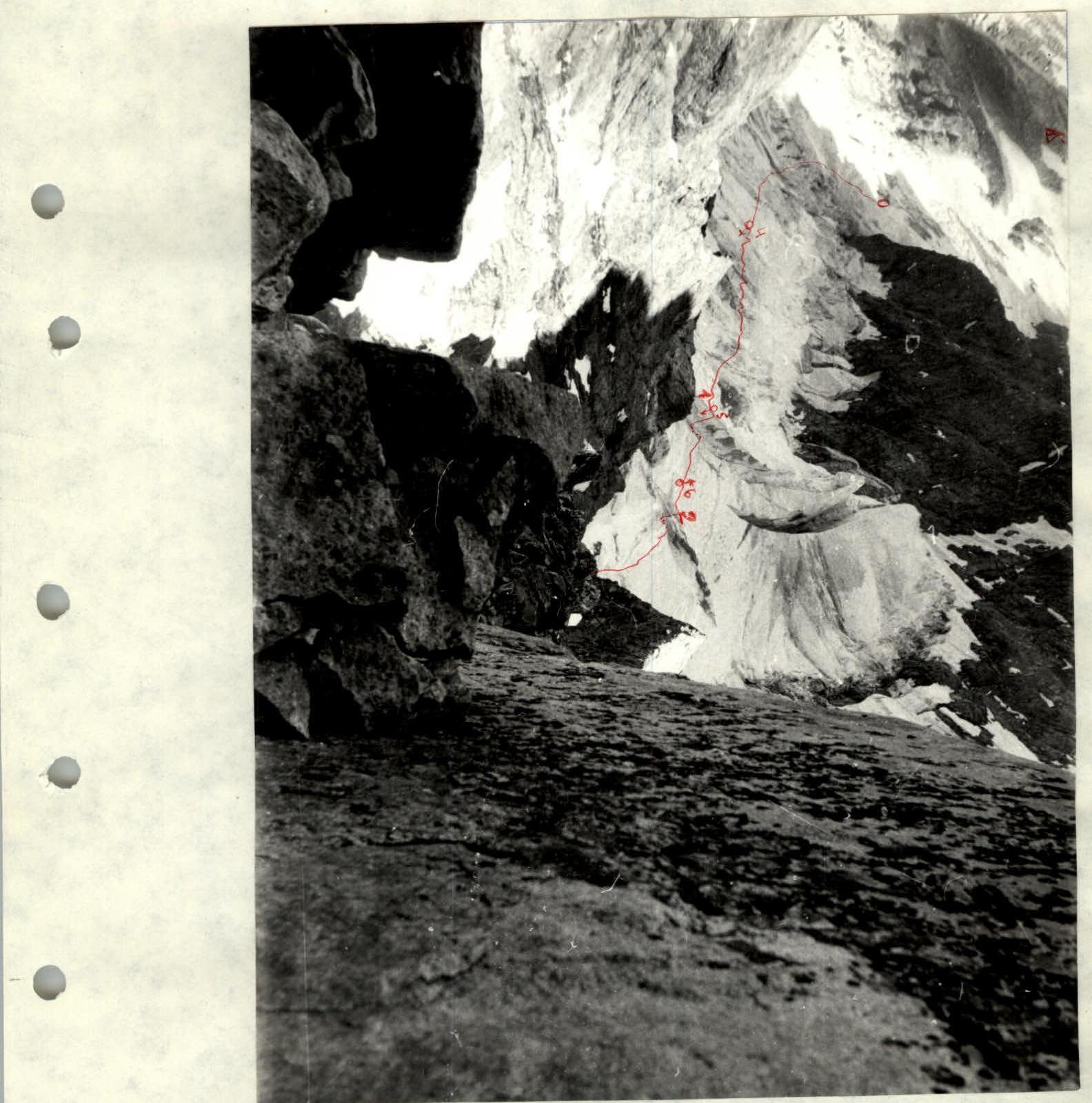
Photo # 8. Sections 0-3 taken from above. Date taken August 6, 1986. Time taken 11:00. Camera "Smena 8", lens "Tair". Location # 7, section 16.
Photo # 11. Section 2-2. Date taken August 4, 1986. Time taken 16:00. 7-meter wall, passed with two bolt pitons. Camera "Smena 8", lens "Tair". Location # 10.
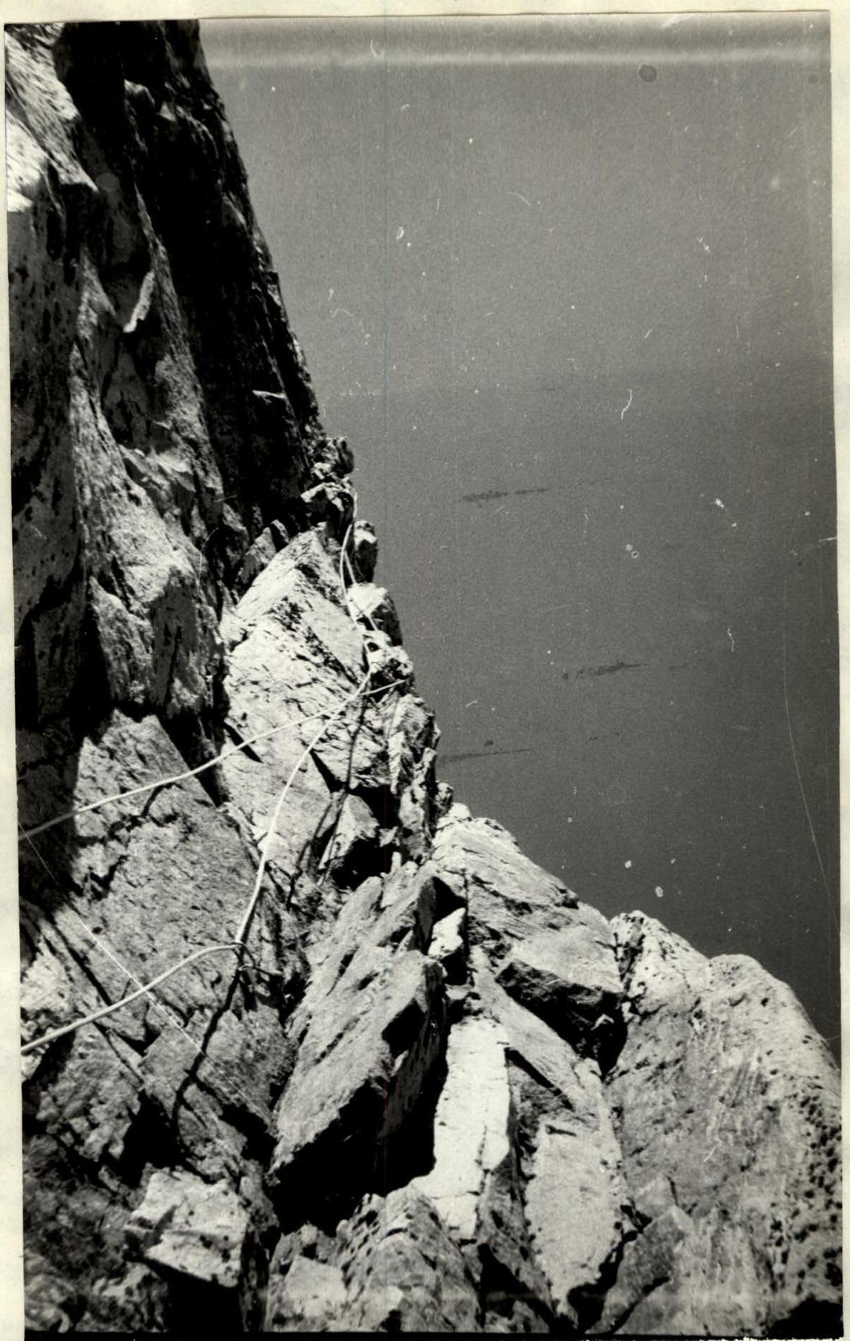
Photo # 12. Section 18-19. Date taken August 4, 1986. Camera "Smena 8". Location # 11.