- Tsalgmyl via Northwest ridge (combined route, V. Sigalov, cat.4A, fig. 32, 43). From Nakra village cross Nakra river and ascend the valley along the trail on the right bank. Before the third stream coming down from the western slopes of Tsalgmyl turn right and continue through the forest, then along the grassy slope of the Northwest ridge of Tsalgmyl. Leave the ridge on the left onto the right-lateral moraine of Tsalgmyl glacier and continue upwards. From the end of the moraine reach the glacier. Traverse the glacier to the left avoiding hanging seracs, then turn right and ascend a steep glacier to the upper plateau above the seracs. From the plateau ascend snowy slopes to reach the platforms on the Northwest ridge of Tsalgmyl. Starting bivak. From Nakra village 6–7 hrs.
From the platforms ascend along the icy-snowy Northwest ridge (cornices) to the black rocks. Pass the rocks in a corner or traverse them on the left. Further ascend along the sharp Northwest ridge, a slab, moderately difficult heavily damaged rocks with snowy connections (cornices) to a platform under the Northern gendarme.
Traverse the gendarme on the left and reach the wall of the rocky belt of the summit. Ascend difficult icy rocks of the couloir wall at 4050 m, then a steep slab of moderate difficulty leading out of the couloir on the left, then 40 m along the monolithic difficult rocks of the wall (crux).
- Moderately difficult rocks of the crest
- Snowy rocky couloir
- Ascend to the Northern rocky
Summit. Ascend along the icy-snowy Northwest ridge (cornices) to the summit of Tsalgmyl. From the starting bivak 10–12 hrs.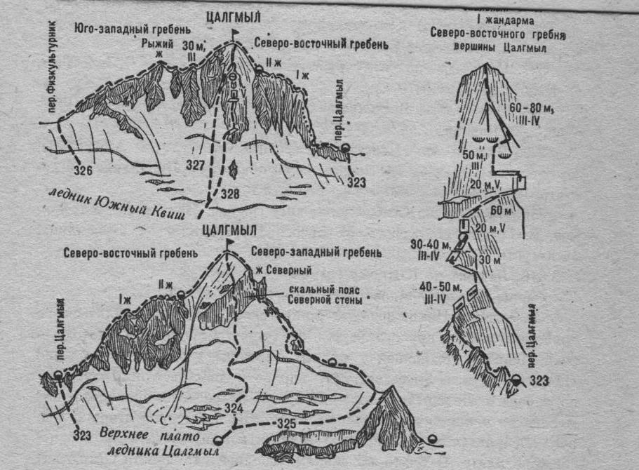
Fig. 43. Nakra spur.