Mt. Ushba 2000 m (C–D), via NW wall and descent to Gul lake («Kрест» / "Cross"), cat. 6A.
1st day — Hike to «Nemetskie nochevki» (German overnight camp) in Shkhelda gorge takes 4–6 hours.
2nd day — From «Nemetskie nochevki» through Ushba icefall:
- Ascend to Ushba pass and enter the upper part of Ushba glacier.
- Following its right edge, approach the NW counterfort of S. Ushba.
- Descend along the counterfort to the point where a glacier tongue "breaks through" it.
- To the left of it, on a rock shelf of Shkhelda slope of the counterfort, there is a convenient site.
3rd day — Descend to the glacier via inclined shelves and approach the I-st bergschrund. Cross the first bergschrund via a rope and then the second one. After overcoming the second bergschrund, reach the rocks of the left (in the direction of travel) side of a steep ice couloir continuing along the counterfort (NW edge), to the left of it.
Further, either via the couloir or the rocks of the left side (120 m), bypassing difficult rocks via ice and vice versa. In the upper part, the left side of the couloir turns into a rocky ridge abutting the left side of the counterfort. Here, one should reach the ridge of the counterfort — this is the most technically challenging section.
To reach the ridge, ascend the wall (40 m) to the right of a wide chimney filled with flowstone ice. Further movement along the ridge:
- Easy rocks — 2 ropes,
- one rope of difficult climbing,
- two more ropes of medium-difficulty rocks, interspersed with snow and ice sections,
which leads to the base of the "yellow" mandarm.
One rope to the right and slightly below the base of the mandarm, separated from it by a short snow-ice slope, is a camping site partially cut into the ice.
4th day. From the campsite, ascend to the mouth of a steep ice couloir stretching along the left (in the direction of travel) wall of the mandarm. Crossing the couloir, exit onto the rocks of the left side and then onto a snowy ridge adjacent to the wall of the "mandarm" (the structure of this and the lower couloir are analogous).
Bypassing the mandarm — 3 ropes, medium-difficulty and difficult rocks. From the point where the snowy ridge adjoins the wall of the mandarm (5 m traverse) — exit to the right onto a rocky saddle in the ridge, separating the summit of the mandarm from the continuation of the ridge. From the saddle, via a chimney (4 m) — ascend to the ridge.
Further movement along the sharp rocky ridge (medium-difficulty rocks) with snowy cornices (3 ropes), which is blocked by a 2nd wall without holds or cracks. Via the wall (1 piton, undercling) — exit onto a rocky site, from which there is an easy exit onto a snowy slope between ice fall sections, and then onto snow-ice fields below the upper bergschrund, to which there are 4 ropes.
Near the bergschrund, there are convenient camping sites. If time allows, it is advisable to:
- process the ice slope above the bergschrund, leading to the saddle,
- or ascend to the saddle.
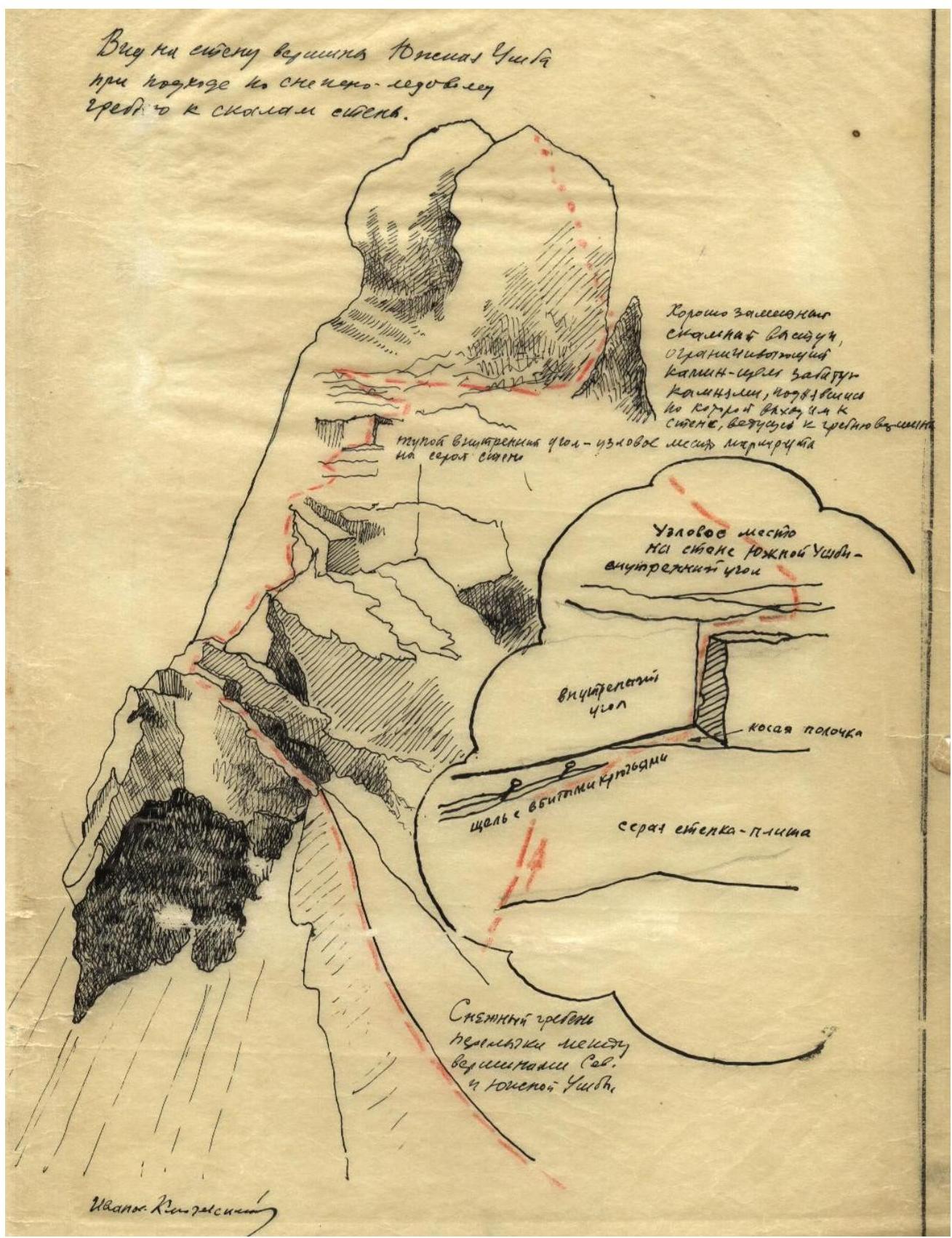
5th day. Exiting from under the bergschrund to the saddle takes from 45 minutes to 3 hours, depending on the slope conditions. Ascend via the slope between two kandarm on the saddle, closer to the summit of S. Ushba. On the saddle, there are camping sites under S. Ushba (on rocky shelves and on snow between kandarm).
The ascent from the saddle to S. Ushba takes about 5 hours:
- initially via snow,
- then exit from the snowy ridge to the left onto the rocky counterfort of S. Ushba,
- further movement via rocks of the counterfort with a deviation to the right.
The route length from exiting onto rocks to the summit is 7 ropes:
- 2 ropes — easy rocky ridge,
- 3rd and 4th ropes — exit onto gray slabs and further up,
- 5th–7th ropes — broken rocks and snowy ridge leading to the summit.
Descent from the summit via the ascent route is organized with 4 rappels (2 hours 30 minutes).
6th day. Ascent from the saddle to S. Ushba takes 2–3 hours and proceeds via a rocky ridge — medium-difficulty and easy rocks.
From the summit, descend to Ushba plateau via route 4A cat. sl., which takes from 5 to 9 hours, depending on snow conditions:
- Initial movement along a sharp snowy ridge with cornices.
- Belaying via rocky outcrops and bends in the snowy ridge.
- At the end of the ridge, organize belays.
- Descend via a wide and steep snow-ice slope and rocks «Nastenko» (280 m).
- Easy rocky ridge (30 m) leads to the descent point onto Ushba cushion — a steep snow-ice slope (80 m).
- On the cushion — simultaneous movement.
- Descend via the slope towards Ushba pass and to the beginning of the icefall.
- Descend via the icefall and to AUSP.
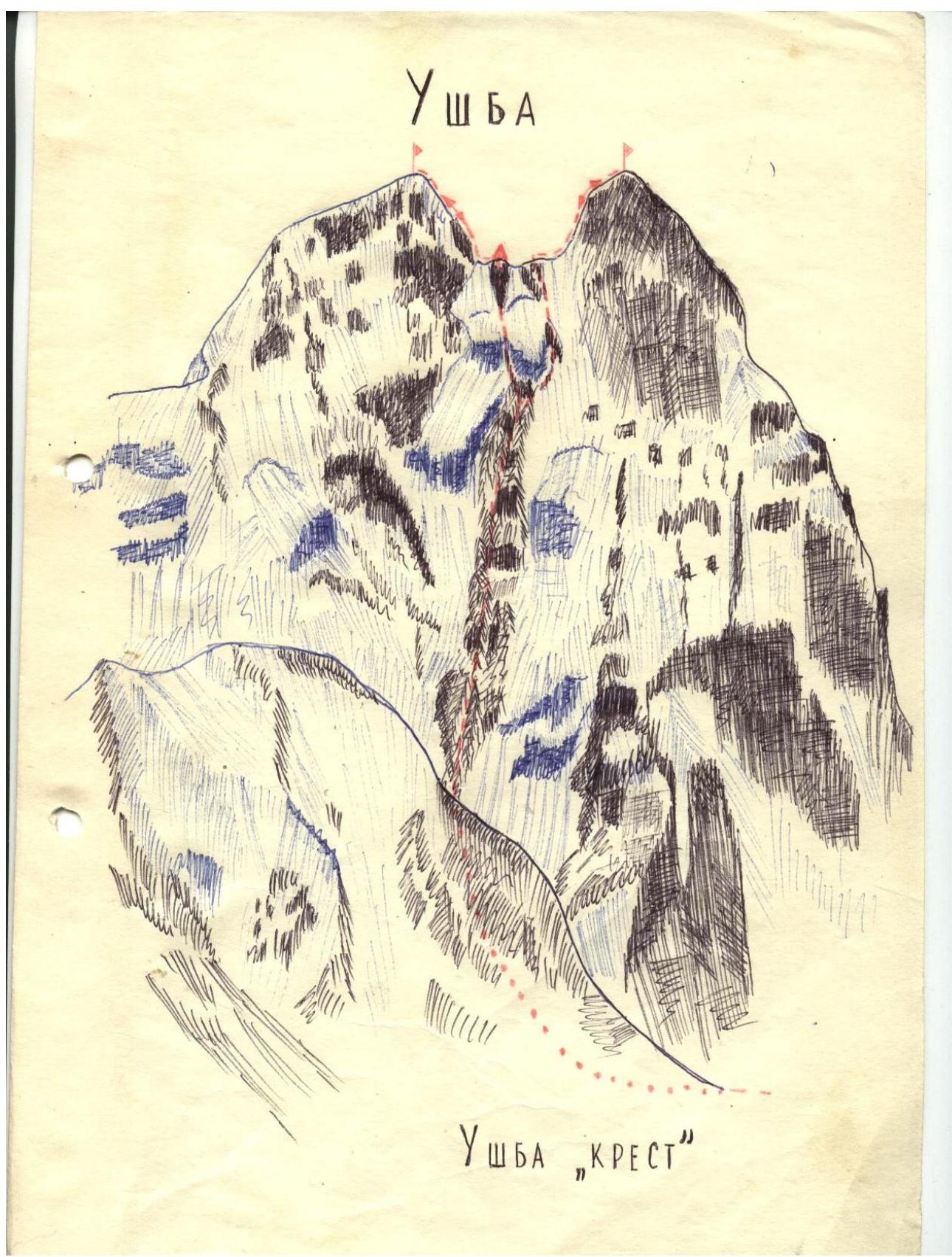 UshBA
«KРЕСТ»
UshBA
«KРЕСТ»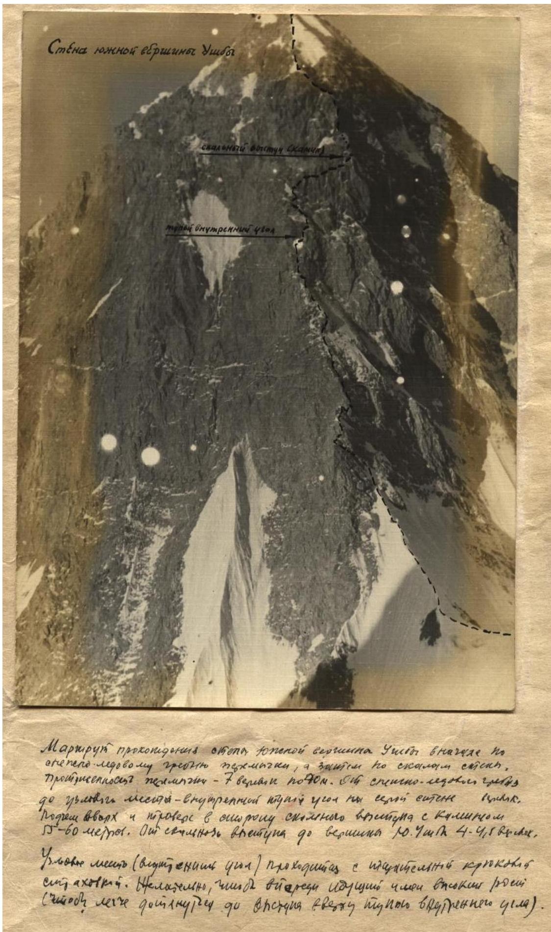
Wann
Rensselaer?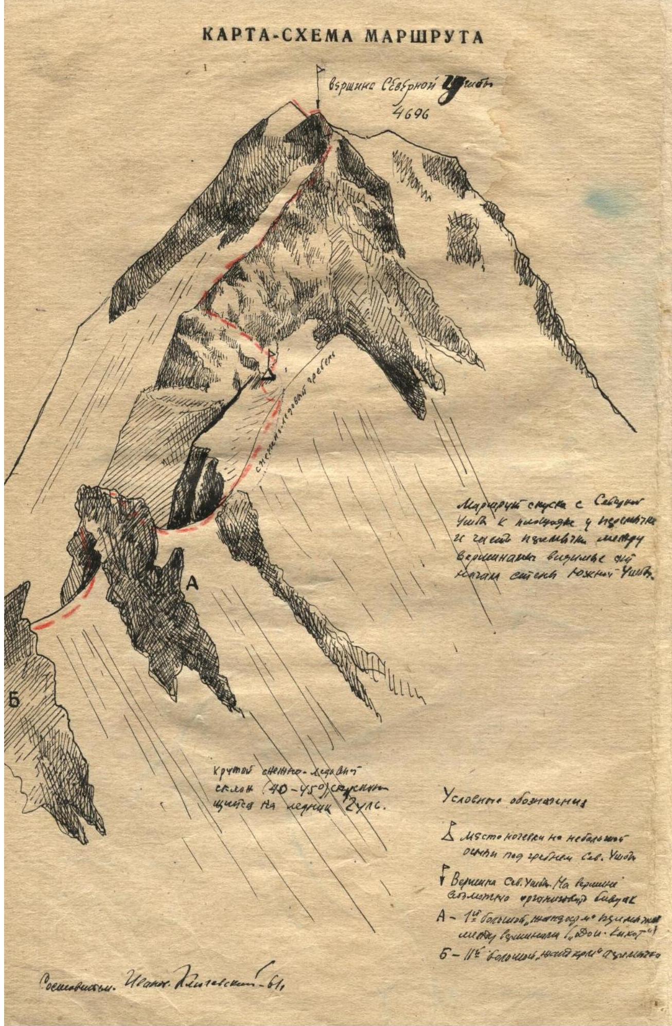
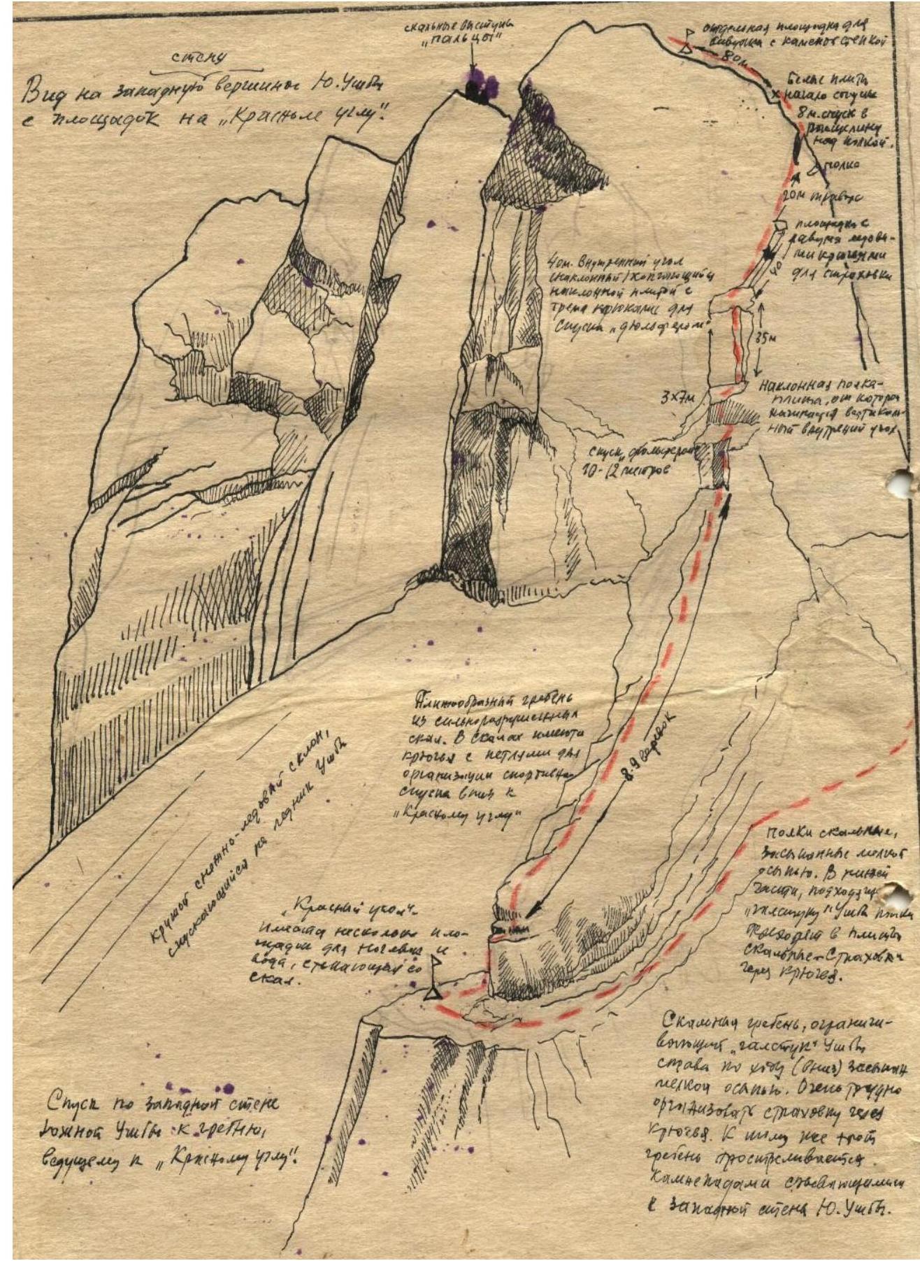
Route map
См. о. п.