344029, Rostov-on-Don, 1st Cavalry Army St., "Planet" club, A.G. Pogorelov
Ascent Log
- CLASS — technical
- ASCENT AREA — Central Caucasus
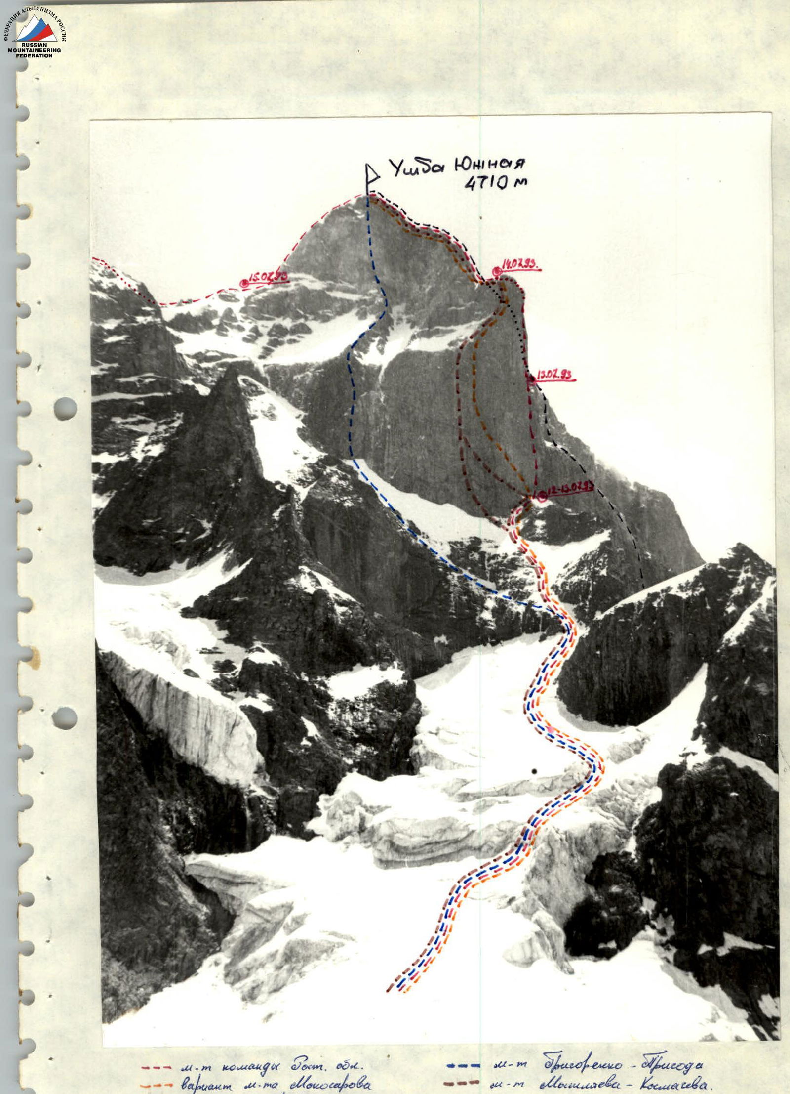
- OBJECT OF ASCENT — Ushba South and North with ascent via the right part of the southwest wall 6B cat. diff. (Kustovsky's route)
- DIFFICULTY CATEGORY — 6B
- HEIGHT DIFFERENCE — 1450 m
- DISTANCE — about 3000 m
- PITONS DRIVEN: ROCK — 136/44 CAMS — 86/21 BOLTS — 14/14 (old) ICE SCREWS — 18/0
- NUMBER OF CLIMBING DAYS: to SOUTHERN SUMMIT TOTAL to "German bivouac" DAYS — 4 6 HOURS — 38 60
- BIVOUACS — 1, 2, 3, 4 on comfortable platforms in a tent, 4 — on descent
- LEADER: Yuri Viktorovich Koshélenko — CMS PARTICIPANTS: Astakhov — CMS Knyazhev — CMS Popov — CMS Nikitenko — CMS
- SENIOR TEAM COACH: A.G. Pogorelov TEAM COACH: A.G. Sheménev
- DEPARTURE FROM BASE CAMP — July 11, 1993 14:00
- DEPARTURE FROM "GERMAN BIVOUAC" — July 12, 1993 6:00
- START OF ASCENT — July 12, 1993 13:00
- REACH SOUTHERN SUMMIT — July 15, 1993 16:00
- REACH NORTHERN SUMMIT — July 16, 1993 13:00
- DESCENT TO "GERMAN BIVOUAC" — July 18, 1993 17:00
- RETURN TO BASE CAMP — July 18, 1993 21:00
Team Tactics
During preparation for the ascent, based on consultations and study of previous climbers' reports, the team developed a tactical plan for the ascent with four bivouacs on the route. The actual ascent was completed with six bivouacs, but the delay occurred on the descent due to safety concerns caused by severe weather.
On the approach, due to the good condition of the glaciers, the team was ahead of schedule, and instead of a planned bivouac on the glacier under the wall, a bivouac was set up on the route before the start of the "pillar". The "pillar" was climbed faster than planned with one (planned) overnight stay on a comfortable ledge on section R7, instead of the planned two.
The passage of the upper part of the "pillar" and further up to the exit to the North summit coincided with the tactical plan, with a one-day lead.
Due to a sharp deterioration in weather on July 16 — snowfall, strong wind with visibility 8–10 m — the team was forced to leave the ridge and set up a bivouac for safety reasons. On July 17, the weather worsened further, and with visibility 5–6 m, the team was only able to hang the available free ropes in the direction of descent. On July 18, with improved visibility, they descended from the summit and returned to the Elbrus base camp. As a result, the descent stage from the North summit required more time than planned due to harsh weather conditions.
The problematic section on the route is the "pillar". When passing through it, the team used the entire arsenal of modern mountaineering techniques: skyhooks, hooked legs, bolt hangers, etc. Two people in the lead rope team were maximally unloaded:
- The first worked without a backpack;
- The second carried only the necessary equipment for the first and down jackets for himself and his partner.
From the products and equipment taken for the ascent, an emergency reserve was created, which was evenly distributed among the backpacks. As a result, the forced delay due to bad weather on the descent did not cause any inconvenience, as there was a supply of fuel and food.
On the route, the team worked with two rope teams and five ropes:
- Koshélenko–Nikitenko–Astakhov
- Popov–Knyazhev
The first worked on a double rope, while the remaining ropes were used in the operational work of the second rope team, as well as in processing the route above the established bivouac.
For overnight stays, there was a specially made tent for the ascent made of parachute nylon treated with a water-repellent compound, two sleeping bags, and three down pants (emergency throws). Everyone had down jackets and warm woolen mittens.
16 kg of food was taken for the ascent, calculated at 450 g per person per day for the planned duration of the ascent, and an emergency reserve for two days at 260 g per person.
The total weight of food, fuel, radio station, bivouac, and assault equipment for the team was 71 kg. The starting weight of the backpack on the approach was 14 kg. A more detailed breakdown by item and weight of equipment is given in the equipment and product tables.
Radio communication with teams making ascents on the West and Northwest walls of Ushba was always problematic. To ensure reliable communication, the team had a "Kaktus" radio station, and a repeater with an extended antenna was located on the Southeast slopes of the Yusengi ridge. This ensured stable communication with the Elbrus base.
The time breakdown of the ascent is detailed in the attached extract from the radio communication log.
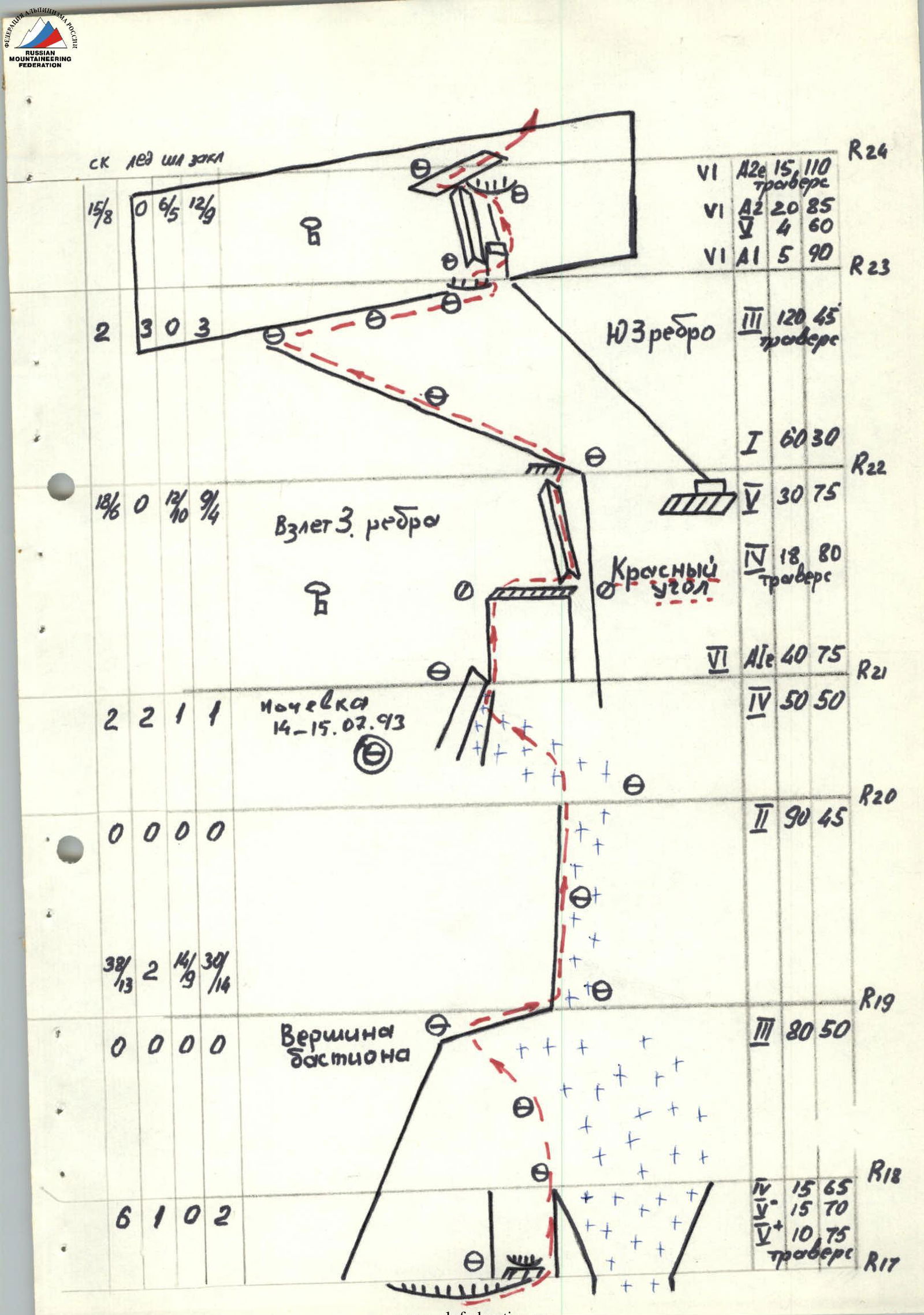
When registering documents, the team submitted two route descriptions — a concise one attached to the route sheet, and a detailed one used during the ascent. This description uses the route section designations adopted in the detailed route diagram provided in the report. In (according to the abbreviated scheme) the designation of sections according to the abbreviated scheme attached to the route sheet is given.
The approach to the route was made via the Chybyn icefall through the Chybyn pass, descent via the glacier under the Shkhelda walls with an exit under the glacier descending from the lower third of the West ridge of the South summit.
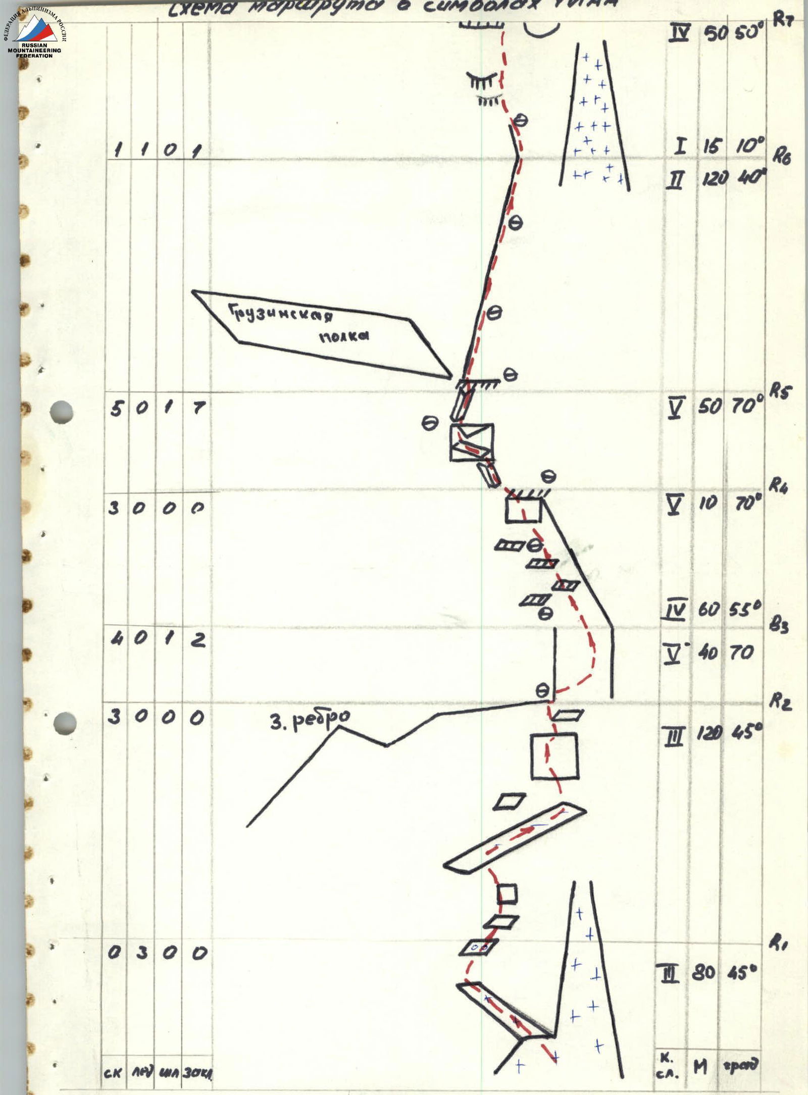
July 12, 1993 (R0–R4)
Section R0–R1. Simultaneous movement of rope teams in crampons on the snow-covered glacier.
Section R1–R2. Through snow-covered destroyed rocks 2–3 cat. diff. exit to snow-covered rocks on the right part of the "Georgian shelf".
Section R2–R3. Through snow-covered rocks on the left side of the West ridge, movement on monolithic rocks with sufficient cracks.
Section R3–R4. Through ledges and a 10-meter wall, exit to a platform on the West ridge.
Section R4–R5. Oblique traverse on the left side of the ridge along a narrow ledge.
Section R5–R6. Simultaneously along a gentle ridge to a comfortable bivouac platform. Here, the first bivouac on the route is organized.
July 13, 1993 (R4–R6)
Section R6–R7. 20 m along a horizontal ridge and further along a snowy slope to the right of snow-covered rocks like "ram's foreheads" and through snow in the couloir — approach to the bastion.
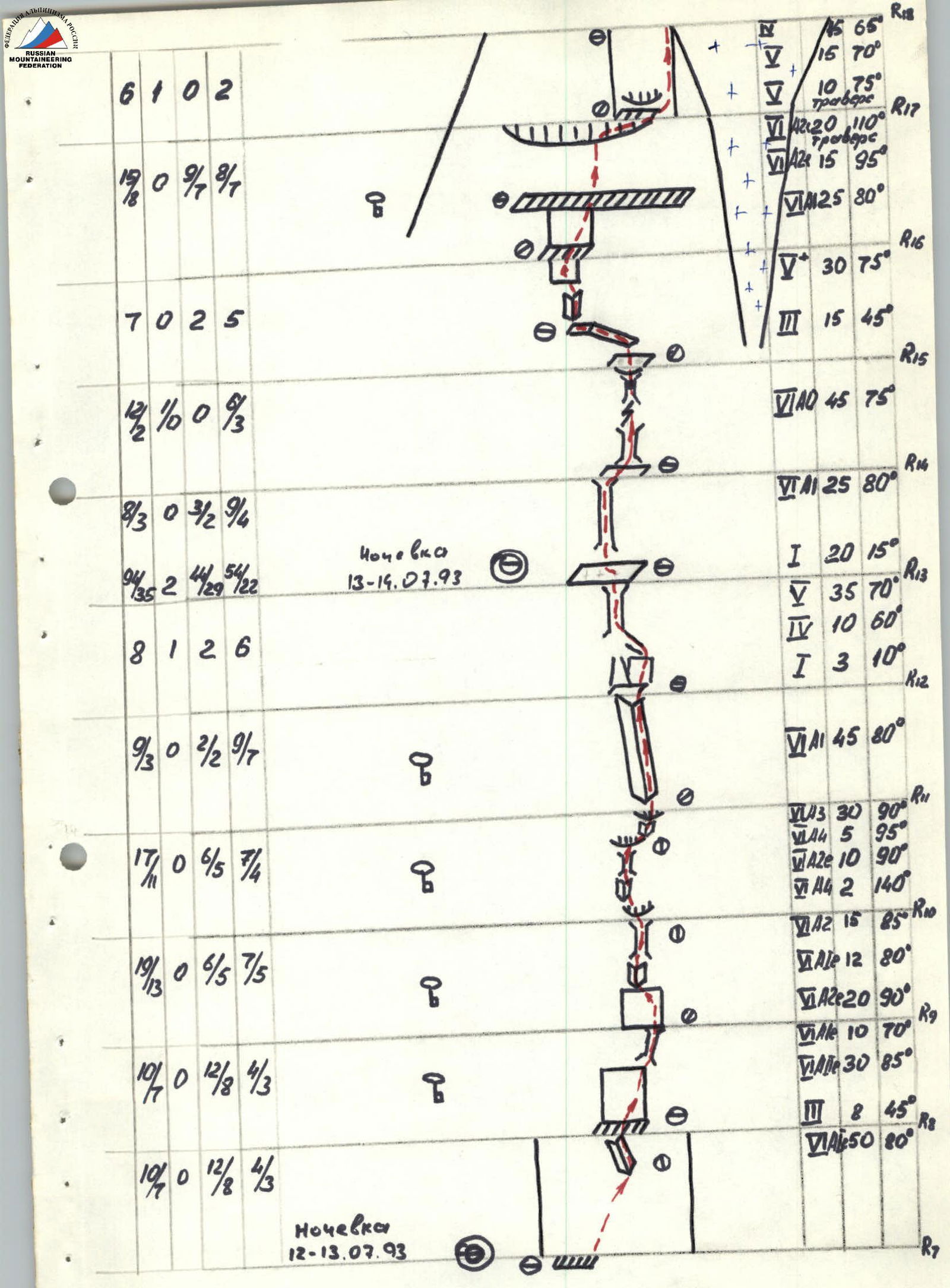
Section R7–R8. Through a monolithic wall of the bastion with a small number of holds. At the top of the section — an internal corner 10 m of difficult free climbing, ending with a small ledge for two.
Section R8–R9. From the ledge upwards through a monolithic wall with a small number of holds and cracks through a wide chimney 10 m — using artificial aids.
Section R9–R10. Through a monolithic wall with an internal, widely deployed corner turning into a chimney. Above the chimney — a cornice. There are no places for organizing an insurance point.
Section R10–R11. "En face" through the cornice using artificial aids on large and medium cams and "friends" — exit to a large relief wall with a limited number of cracks and holds. Through two overhanging sections (artificial aids) — approach to a long internal corner.
Section R11–R12. On the right side of the internal corner 45 m of ice-filled and snow-covered rocks — exit to a snow-covered platform.
Section R12–R13. Through a heavily dissected section with increasing steepness — from 10° at the beginning to 70° at the end — exit to a wide snow-covered ledge. Here, a bivouac is organized.
July 14, 1993 (R6–R9)
Section R13–R14. 20 m through simple rocks — approach to a chimney. 25 m through a chimney, partially filled with ice. The first works in crampons, uses pitons and wide cams. The wind blows spray from the "funnel".
Section R14–R15. 25 m through a chimney, partially filled with ice, turning into a thin crack and again turning into an ice-filled chimney, another 25 m — and exit to the right onto a ledge under overhanging rocks. Rocks are wet from spray blown from the "funnel".
Section R15–R16. From the ledge to the left through an overhanging internal corner (artificial aids, old bolt hangers), further upwards through a destroyed wall with rich microrelief to a small ledge. Constant "rain" from the "funnel".
Section R16–R17. From the ledge upwards to the right through a vaguely expressed ledge of an overhanging wall — exit to a wide horizontal ledge narrowing towards the "funnel". Above the ledge, the overhanging summit part of the bastion protects from the "rain" of spray. From the ledge through an overhanging wall under a cornice and under it — traverse to the right to its edge, exit to a small ledge under the next cornice. Rocks with small, deep cracks.
Section R17–R18. The cornice is passed upwards to the right (artificial aids), then upwards to the left — exit to the edge of the "pillar". Rocks with small, deep cracks are filled with water.
Section R18–R19. Through a steep snowy slope — exit to the summit of the "pillar".
Section R19–R20. Movement along the gentle ridge of the "pillar" summit.
Section R20–R21. Traverse to the right and upwards through a snowy-icy slope above the "funnel" in crampons with insurance through an ice axe, and where possible — using ice screws towards the "Red angle". Exit to a ledge and organization of a bivouac.
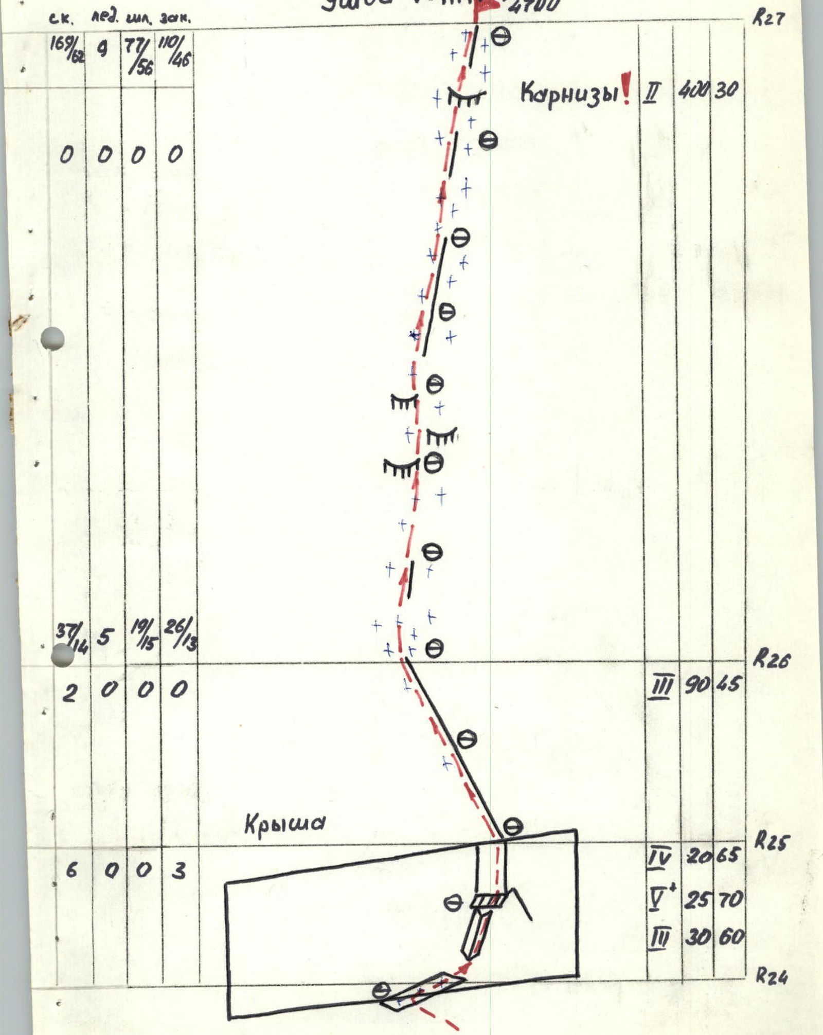
July 15, 1993 (R9–R12)
Section R21–R22. Through a monolithic wall 7 m using artificial aids on old bolts and further free climbing and traverse 20 m to exit to the summit of the Southwest ridge.
Section R22–R23. Through rocks of medium difficulty on the right side of the Southwest ridge — movement towards the summit bastion.
Section R23–R24. To the right through a wall from a large internal corner — exit under an overhang. Further traverse under the overhang to the left (artificial aids) — exit to an inclined slab.
Section R24–R25. To the right and upwards through inclined slabs and steep rocks with many holds — exit to the "roof".
Section R25–R26. Movement along a simple rocky ridge.
Section R26–R27. Through a snow-covered rocky, and then snowy ridge with cornices — exit to the South summit.
(R12–R13). 20 m through a snow-covered ridge — descent towards the North summit. Through heavily dissected steep rocks — descent to a saddle. Further through a sharp snowy ridge with cornices — approach under the tower of the North summit, and at the place where the ridge widens — organization of a bivouac.
July 16, 1993
(R13–R14). Through heavily dissected steep rocks of the North summit tower, and then through snow-covered rocks — exit to the North summit.
July 16–18, 1993
(R14). Along the descent route from the summit, two snowy ridges begin. Through the left, initially gentle, and then increasingly steep, North ridge — descent towards the "Ushba cushion". Movement is alternate, either directly along the sharp snowy ridge with cornices, or along its left part through steep snow and ice. Careful insurance through ice axes, and more often through ice screws. For descent along the ice "board", it is convenient to have a device for pulling through on ice. After passing the ice board — descent to the right onto the "Ushba cushion".
 www.alpfederation.ru↗
 www.alpfederation.ru↗
 www.alpfederation.ru↗