ASCENT DOCUMENT.
- Ascent category — technical.
- Ascent region — Central Caucasus.
- Object of ascent — Ushba South peak (4710 m) via the right part of the SW wall (Kustovsky route) 6B category of complexity.
- Height difference of the wall section — 580 m. Total height difference — 1460 m.
- Total route length — 1897.5 m, including sections of 5–6 category of complexity — 835.5 m.
- Average steepness of the route — 68°, including the wall section — 80°.
- Pitons hammered:
| rock | ice | bolt | chocks |
|---|---|---|---|
| 76 + 5 × | 4 | 60 × | 227 |
| 5 | 35 × | 22 |
- Number of climbing hours — 33, days — 3.
- Number of bivouacs on the route — 2. 1st lying, 2nd sitting.
- No water on the wall section.
- Team leader: Kravchenko O.V. CMS
Team members:
- Aristov I.E. CMS
- Kadoshnikov N.G. CMS
- Yudin A.N. CMS
- Yakimov A.N. CMS
- Team coach: Akhtyrsky O.L. MS
- Departure to the route: July 21, 1993. Reaching Ushba peak: July 23, 1993. Return to base camp: July 25, 1993.
- Ascent organized by the Department of Krasnodar Department of Physical Education and Sports.
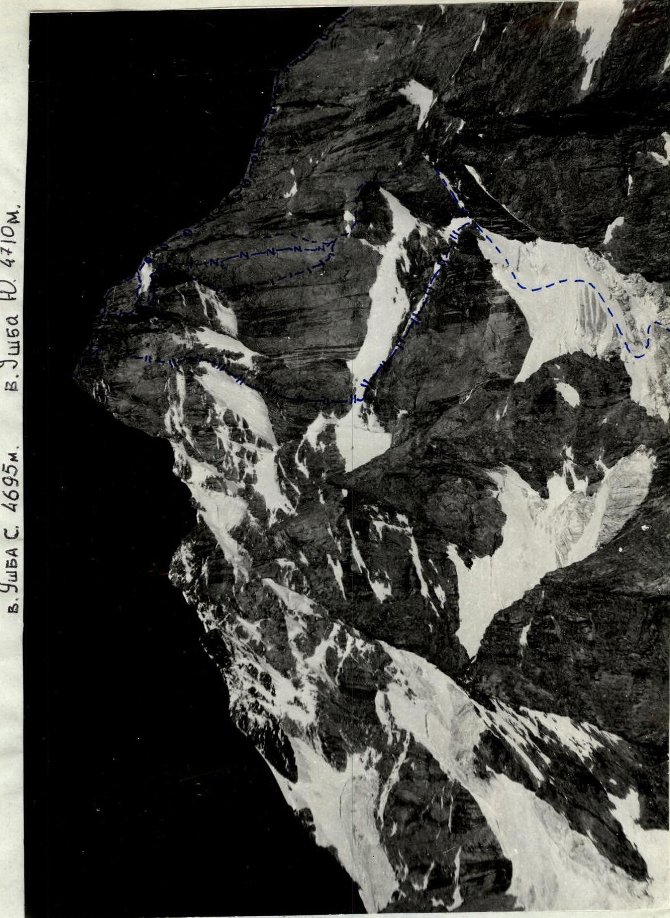
PHOTO #1. General photo of Ushba South peak. Lens "Industar 94".
- — — — — Kustovsky route
- – – – – Myshlyaev route
- – – – – Grigorenko–Prigoda route
- – – – – MikhMonegarov route
Team Tactics
The tactical plan was based on consultations received, route description, and visual assessment of the route's nature and complexity. The team's equipment and food supply were planned for deteriorating weather conditions.
When choosing a tent, it was considered that a night stay on narrow ledges, where setting up a frame tent is not always possible, was not ruled out. Therefore, preference was given to a conventional "perkal" tent.
Equipment was also selected considering the likelihood of a sharp deterioration in weather, including the need for the first climber to work on icy sections in crampons. The set of technical means included:
- Pitons, various chocks, "heavenly" pitons, "friends", "hook-legs" with tape ladders.
In case of unforeseen situations, a drill with a set of reusable bolt pitons was available.
Throughout the route, the lead climber was completely unloaded. The rest moved along the rope, carrying backpacks or attaching them with a short rope to their harness.
To increase the reliability of belays, movement along the route was carried out according to the X+1 scheme, i.e., the number of ropes in use equaled the number of team members (5), plus one.
Almost all participants, except the lead, moved with top-rope belay. The lead climber went on a double rope, one of which met all UIAA requirements, with a shock absorber. When necessary, the lead climber's belay was carried out using Kashevnik's "sukačka".
Bivouac sites were chosen on safe sections, out of reach of falling rocks.
Although any team member could lead, it was decided not to change the leader during the working day. This allowed:
- saving time,
- increasing safety.
During the ascent, Aristov I. and Kravchenko O. led. Other team members performed no less complex and responsible work. Some deviation from the tactical plan was caused by unusually warm weather, which led to:
- deterioration of snow conditions,
- increased rockfall danger,
- intensification of the waterfall.
Stable radio communication with the base camp was maintained using a "Karat" radio station.
A sufficiently complex ascent in all respects was completed by the team quickly, safely, and with a sufficient margin of safety.
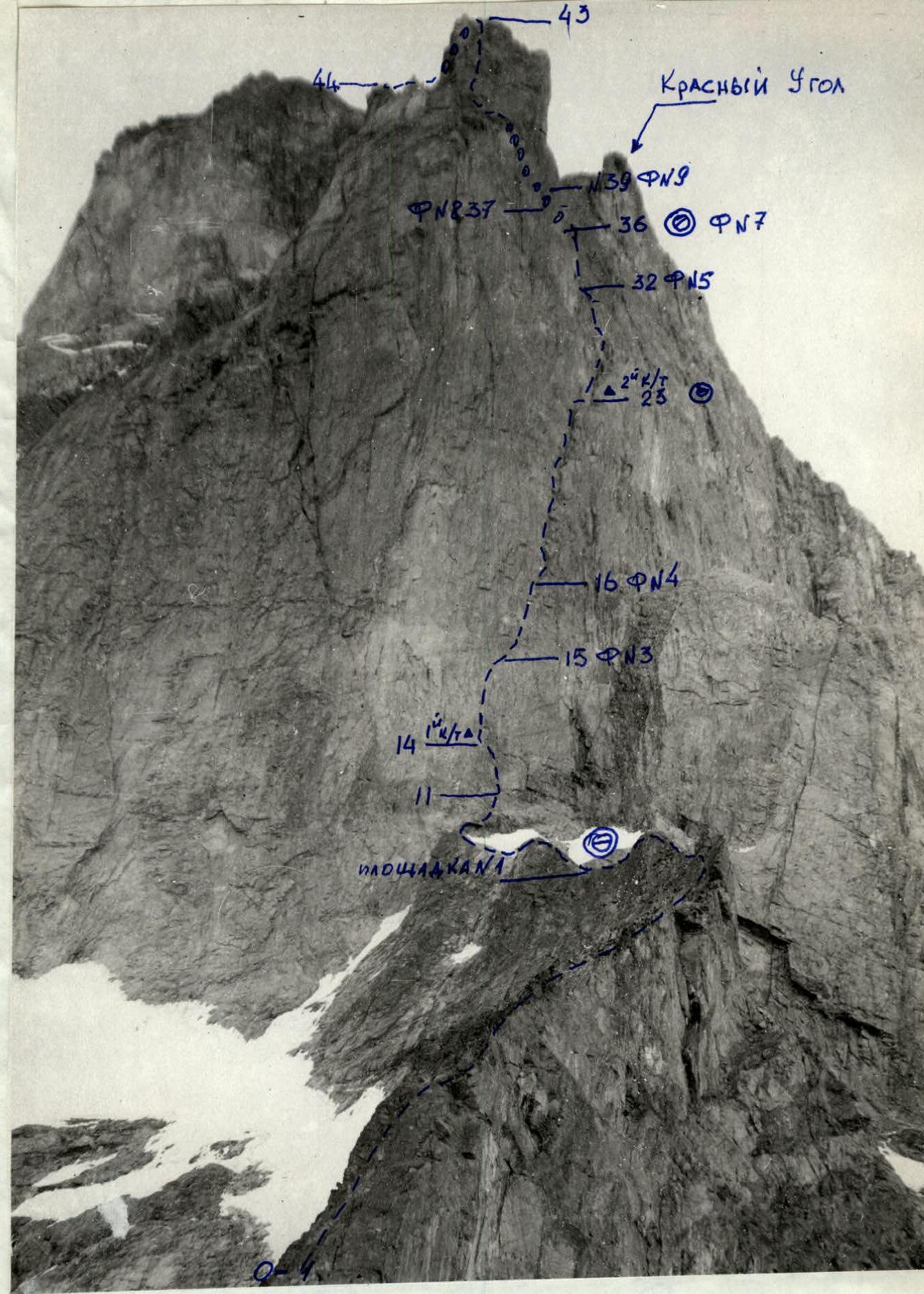
PHOTO #2. Technical photograph of the route. Lens "I-94".
Route length — 1897.5 m Including sections of V–VI category of complexity — 835.5 m Used: rock pitons — 60 ×; ice pitons — 4; chocks — 237.
Route Description by Sections
The route is fairly logical, although there is a possibility of going astray following previous climbers' incorrect path. However, any deviation to the side leads to smooth walls or overhangs, so one will soon have to return to the route. Throughout the route, there are many traces — from bolt pitons to wooden wedges and chocks. The ropes hanging to the right of the route may be misleading, but the logic of movement along the route makes one leave them aside. The very bottom part of the "pillar" is exposed to falling rocks from the top of the "pillar", so it needs to be traversed with great caution.
Throughout the bastion, there is only one convenient and safe place for a bivouac — R23.
Sitting bivouac on R36.
Sections:
- R0–R1: From the glacier, along a snow-ice slope towards the "Georgian" ledge, pressing to the right, then bypassing the bergschrund on the left.
- R1–R2: A wall with a large rock relief, местами in трещинах, snow with ice.
- R2–R3: A simple internal corner, belaying through outcrops, chocks, pitons.
- R3–R4: A cornice is bypassed on the right with an exit to a simple internal corner, belaying through chocks.
- R4–R5: A wall with a fragmented rock relief.
- R5–R6: A simple slab.
- R6–R7: A simple sharp ridge, caution is necessary during simultaneous movement.
- R7–R8: A steep sharp ridge.
- R8–R9: A small slab with good cracks for chocks.
- R9–R12: A large rock wall with a bypass of cornices on the right. Belaying mainly through chocks. Exit under the "bastion".
- R12–R13: A steep wall. Movement in the direction of the memorial plaque is done by "free" climbing.
- R13–R14: Traverse along a ledge to the right.
- R14–R15: A difficult wall. The direction of movement is logical. In some places, the use of artificial climbing techniques (ACT) in the form of old bolt pitons and chocks.
- R15–R16: A small ledge to the right, but not too much, if you go to the attachment point of old ropes, it's a dead end.
- R16–R17: Difficult climbing, but no problems with belaying.
- R17–R18: A system of internal corners and chimneys, use of ACT.
- R18–R19: A rock cornice, ACT, direction to the left.
- R19–R20: A vertical internal corner, narrow slots for rock pitons.
- R20–R21: A chimney with an overhanging rock plug.
- R21–R22: An overhang is traversed "head-on".
- R22–R23: A system of internal corners. When moving, it's better to stick to the right wall, where there are no "live" rocks.
- R23–R24: A convenient ledge for a bivouac.
- R24–R25: A system of internal corners and chimneys. Rocks are icy.
- R25–R26: A chimney with a wall. Belaying through chocks and old bolt pitons.
- R26–R27: A fragmented steep rock relief. The direction of movement is logical, no problems with belaying.
- R27–R28: A steep smooth wall with little relief. ACT, ladders. Belaying is reliable.
- R28–R30: Alternation of walls, internal corners, ledges. Many wide cracks for chocks. There are old bolt pitons.
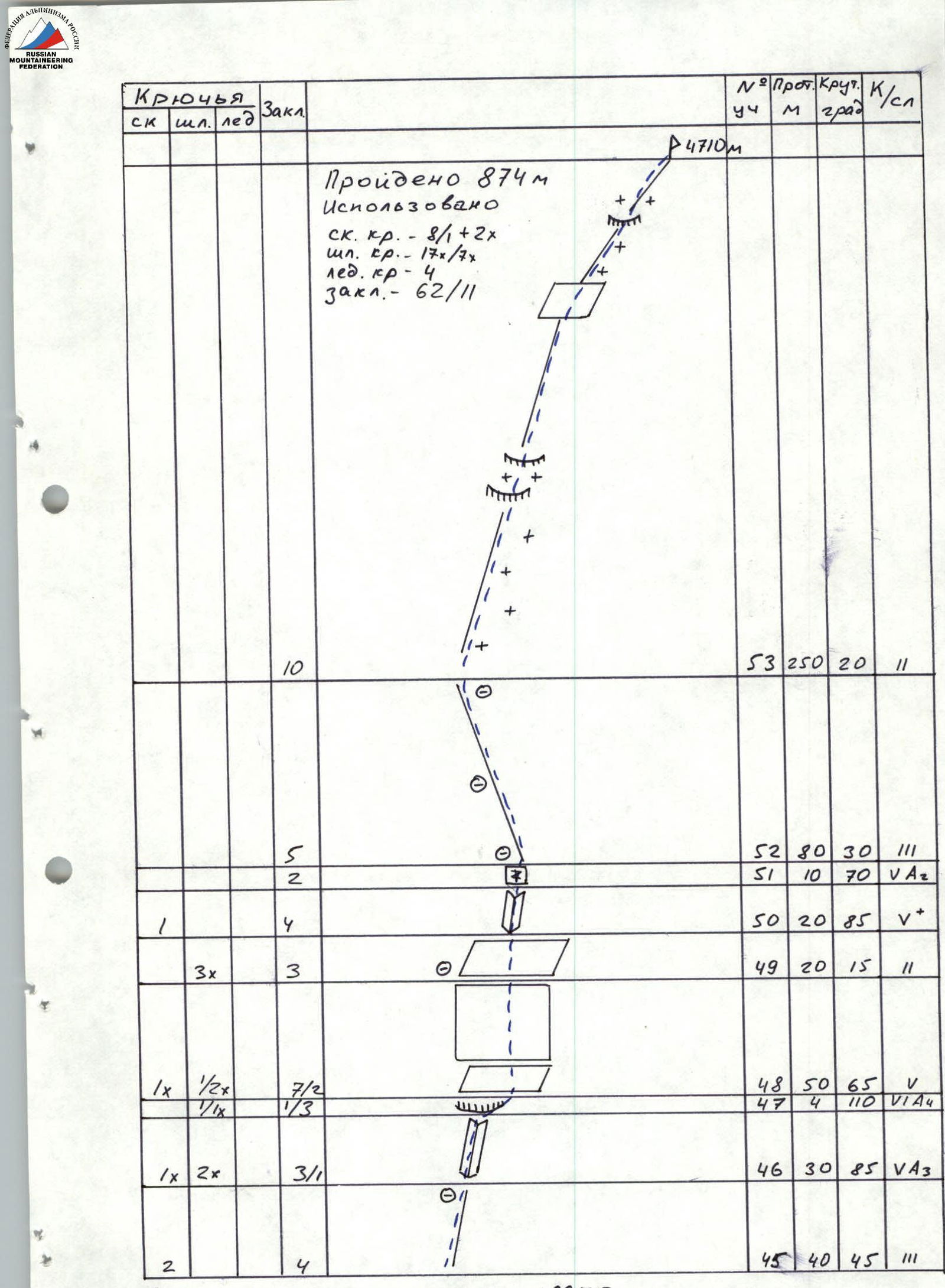
- R30–R32: A very difficult wall. Work on ACT. Exit under the Waterfall. In the second half of the day, it can be impassable due to water and rocks from the funnel.
- R32–R33: A chimney exiting onto a wall. Very difficult climbing, partly ACT, reliable belaying through chocks, bolt pitons.
- R33–R36: A steep, very difficult wall. Work on ACT. Narrow slots for pitons, bolt pitons. Reliable belaying. In the second half of the day, exposed to rocks from the funnel.
- R36–R37: A narrow ledge under a cornice. A sitting bivouac is possible. The cornice is traversed to the left. ACT, bolt pitons. It's possible to bypass the cornice on the left.
- R37–R38: A very difficult wall with reverse grips, small cornices. ACT, ladders, diagonal rope.
- R38–R40: Exit into the funnel, then onto the ridge of the "Pillar" peak. Rockfall danger. Traverse before 14:00.
- R40–R42: A wide simple scree ridge.
- R42–R43: A smooth slab with few grips. In the upper part — a cornice, traversed using ACT. There are old bolt pitons.
- R43–R44: A simple rock-snow ridge. Belaying for outcrops.
- R44–R45: A snow-ice slope. Traverse in the direction of the rock ridge. Ice screws. In the second half of the day — rockfall danger.
- R46–R51: Exit onto the "roof". Route 5A category of complexity. Many traces. Reliable belaying. In some places, ACT, ladders.
- R52–R53: The summit ridge. Simple, in some places scree. Belaying for outcrops.

PHOTO #9. Section #38. Lens T-43.