1985 RSFSR Championship. First Ascent Category
Malaia Ushba 4200 m.
via the Southwest Buttress, cat. 5B (approx.)
First ascent.
Team from the Kursk Regional Sports Committee.
Team Leader — Valentin Alexandrovich Kudryavtsev, Candidate Master of Sports, 1st category.
Team Coach — Valentin Alexandrovich Kudryavtsev, Candidate Master of Sports, 1st category.
Addresses and Phone Numbers
Organizations: 305000, Kursk, Krasnaya Square, 6. Kursk Regional Sports Committee. Team Captain: 305040, Kursk, Aerodromnaya St., 7, apt. 9. Valentin Alexandrovich Kudryavtsev. Team Coach: 305040, Kursk, Aerodromnaya St., 7, apt. 4. Valentin Alexandrovich Kudryavtsev.
Elevations were determined using an altimeter and a map.
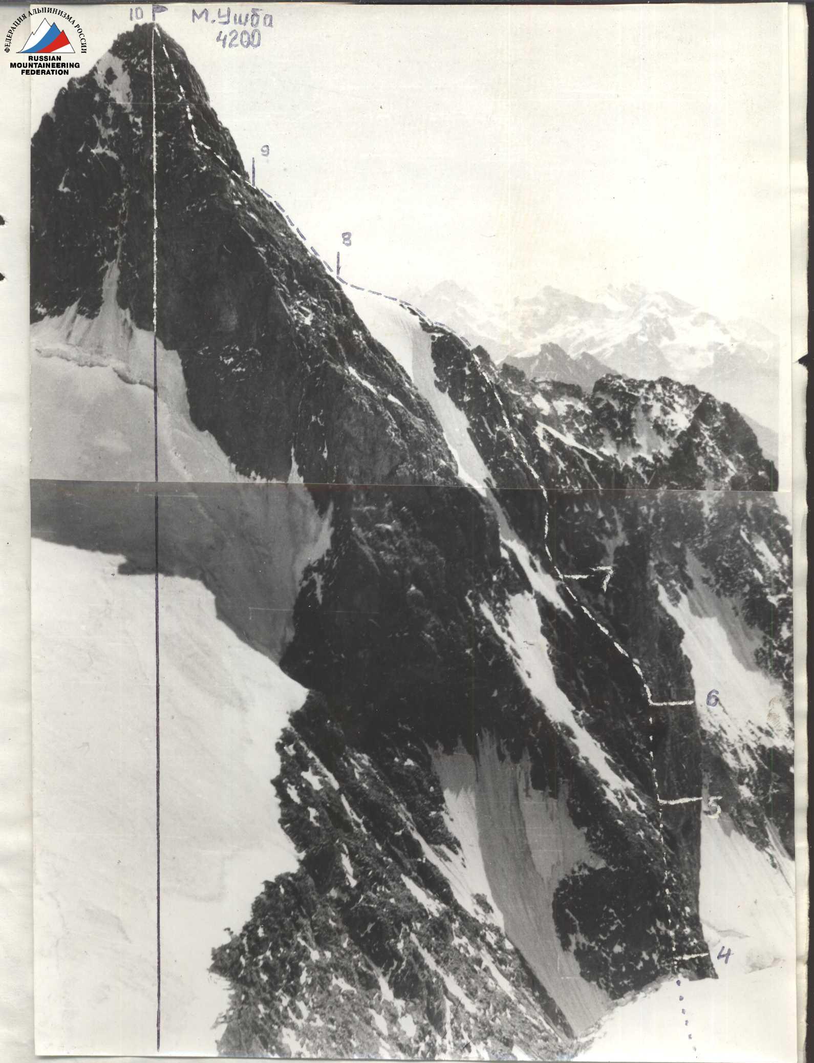
Photo of the wall profile from the left. Taken on August 27, 1985, 11:00. Elevation 4050 m, distance 500 m. Shooting point 2. Industar-26M lens, focal length 5 mm. ---- visible part of the route, .... — invisible part of the route, numbers on the shelves — section numbers according to the UIAA scheme.


M. Ushba. 4200 m. August 26, 1985, 17:00.
Drawn profile of the route. Scale 1:2500 (1 cm = 25 m)
Average steepness 59°. Steepness of sections II–V cat. difficulty 82°.
August 26, 1985, 7:00. August 25, 1985, 20:00.
Scale 1:50.0
Legend: — shooting point — group's path
Map of the Ascent Area
Brief Overview of the Ascent Area
Malaia Ushba (4200 m) is one of the peaks of the Main Caucasus Range, located in the upper Shkheldinsky valley on the southeastern edge of the Ushba plateau between Zapadny Chatyn and Severnaia Ushba.
To the north, the Ushba plateau adjoins Malaia Ushba, bounded by the peaks of Ushba, Shkhelda, p. Shchurovskogo, and Chatyn. To the south, on both sides of Malaia Ushba, steep, heavily crevassed, avalanche-prone ice and snow couloirs descend. Their average steepness is 45–50°. Technically, the descents via these couloirs are almost equivalent and require organization of 6–8 rappels and down-climbs. The couloirs surround the southern wall of Malaia Ushba, merging into a wide snow and ice slope leading to the Chalaat pass.
Two routes are classified on Malaia Ushba from the Ushba plateau. From the Chalaat pass, a route of category 2B difficulty follows the Northeast Ridge (the traditional descent route from the summit). From Severnaia Ushba, a route of category 3A difficulty ascends.
Three routes of category 5B difficulty are classified on Malaia Ushba from the south.
In 1971, a first ascent was made via the South Wall by Kensitsky's team; in 1977, a second route was laid through the center of the South Wall by Gorodetsky's team. In 1981, a team of Ukrainian climbers led by Grigorenko—Prigoda ascended via the Southwest Wall.
The routes on Malaia Ushba from the south are characterized by their wall nature, distinguished by great steepness and monolithic rock. A series of rocky couloirs and internal corners run along the walls, making these routes safe at any time of day. There are few convenient bivouac sites on the route: below the route and at the top on the "roof". Water is absent on the wall sections of the routes.
The approach traditionally follows the Shkheldinsky valley to p. Shchurovskogo (5–6 hours from the Elbrus region's KSP), then an ascent via the Ushba icefall onto the Ushba plateau (2–4 hours), and a descent to the route via the Chalaat pass or the saddle between Malaia Ushba and Severnaia Ushba (2–4 hours). The descent from the Ushba plateau should be planned for the morning hours. The descent couloirs are prone to avalanches and rockfall.
Preparation for the Ascent
The ascent objective was chosen by the team in 1984. In June 1985, they familiarized themselves with photographic materials from the region's KSP, routes ascended via the South and Southwest walls of M. Ushba—Kensitsky, Grigorenko—Prigoda, and Gorodetsky. From July 5 to 8, 1985, the team conducted a preliminary reconnaissance of the first ascent objective, during which they finalized the route, ascent, approach, and condition of the Southwest wall. Preliminary photography and visual (binocular) familiarization with the ascent objective were conducted.
The route was envisioned as combined: areas with frozen rocks and a central section featuring a 300-meter (key) vertical wall.
Based on the reconnaissance, the team conducted additional training sessions on ice and rock, where they practiced teamwork, rope hauling, and passing through belays while attaching backpacks to harnesses, and selected equipment. During July and August, the team conducted training ascents of categories 4–5 difficulty on the peaks p. Shchurovskogo, Ullu-Kara, MNR, and Tytuiu 2nd Western. Based on the preliminary reconnaissance, a preliminary tactical plan for ascending Malaia Ushba via the Southwest wall's buttress was developed.
The coach administered a physical and technical preparedness exam to all team members.
The main initial data for drafting the tactical plan included:
– the route is combined, featuring ice and snow sections at the beginning and end, frozen rocks in the first half (visual observation—binoculars); – elevation gain 800–900 m, approximate length of sections of categories 5–6 difficulty — 250–300 m; – availability of sufficient bivouac sites.
The problematic section was considered to be the middle part of the route—the wall of an internal corner, 300 m, vertical in places with overhangs. The problem lay in the significant length of the sheer rock section with few holds and cracks.
The tactical plan envisaged passing this section using artificial technical aids (IT), with the entire group following belays and the first climber ascending without a backpack.
Ascent Schedule
August 28, 1985, 17:00, Ushba (M) summit, elevation 4200 m, sunny, temperature 18 °C, clear, windy.
Sunny, temperature 15–20 °C. August 25, 1985, bivouac on the shoulder below the wall, elevation 3610 m, good weather conditions, nighttime temperature 3–5 °C below zero.
Sunny, temperature 15–20 °C. August 24, 1985, bivouac on the Ushba plateau, elevation 3980 m, nighttime temperature 5–8 °C below zero.
Team's Tactical Actions
The final tactical ascent plan was compiled after the reconnaissance sortie under v. M. Ushba from August 5 to 8, 1985, where the route for the first ascent, potential bivouac sites, and time required for individual sections were finalized.
Visual inspection of key route sections using binoculars determined the selection of equipment:
– shock absorber; – reusable piton hooks; – adjustable chock.
During the ascent, the team adopted the following movement schedule:
a) departure from the bivouac at 7:00; b) one-hour rest (lunch) from 12:00 to 13:00 (if possible); c) stop for bivouac from 19:00 to 20:00 (if possible); d) on the first day of ascent (August 25, 1985) — processing the wall.
The team's communication with the base was facilitated through an interaction group on the Ushba plateau using a "Karat–211" radio station. Given the specific weather conditions in the ascent area, the team had a time reserve (2 days) for potentially waiting out bad weather on the route. Each team member had an individual nutrition kit and a first-aid kit for emergencies. In case of separate overnight stays, each member had a bivouac kit (mat, bivouac sack, down suit).
-
R1. Ice and snow slope. The bergschrund was traversed alternately with the organization of belays on the bergschrund wall and on the slope above it. Passed on August 25, 1985, 11:00.
-
R2. Beginning of the buttress up to the bivouac site. Rocks of categories 3–5 difficulty with good holds in the lower part. The internal corner was heavily damaged with loose rocks. The section was traversed alternately on a shortened rope. The Kudryavtsev—Fursov team led. In the upper part of the internal corner, teamwork was organized between the teams. Passed on August 25, 1985.
-
R3. Bivouac on the buttress shoulder (lying down). The site was chosen during reconnaissance, safe from rockfall. Water available (stream). Rockfall-prone section from 15:00. The Domrachev—Kruglovenko team processed the wall section of the route (by evening, 120 m of belays were set).
-
R4. Sheer wall (250 m). Rocks of categories 5–6 difficulty with overhanging sections, monolithic with limited holds. The Domrachev—Kruglovenko team led. The first climber worked without a backpack using IT. In the middle part of the wall, two piton hooks were hammered in for protection. The wall was traversed with teamwork and organization of belays. The first climber worked on a double rope in a helmet. Belays were mostly traversed with protection. In the morning, the lower part of the wall was icy with holds. No rope hauling was used. The group had three rappel devices (for the duration of the wall passage). Backpacks were raised under the harness.
R0–R10. Rocks of categories 3–4 difficulty with sections of snow crest. A section of snow-covered, partly icy rocks. In this part of the route, teams moved mostly autonomously using a shuttle system, with the Kudryavtsev—Fursov team leading.
Particular caution was required when traversing the 30-meter wall on section R6–R7. Teamwork was organized here.
The descent from the summit followed the NE ridge with organization of a 30-meter combined (rappel and sport) descent on the ridge and a 60-meter descent from the ridge onto the plateau via the north wall.
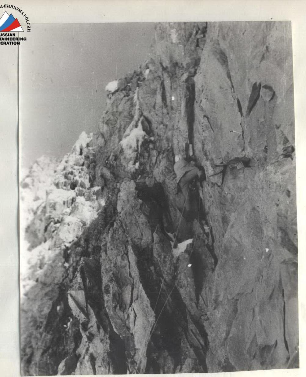 Photo 5. Traversing the internal corner on section R3–R4. August 26, 1985, 8:00.
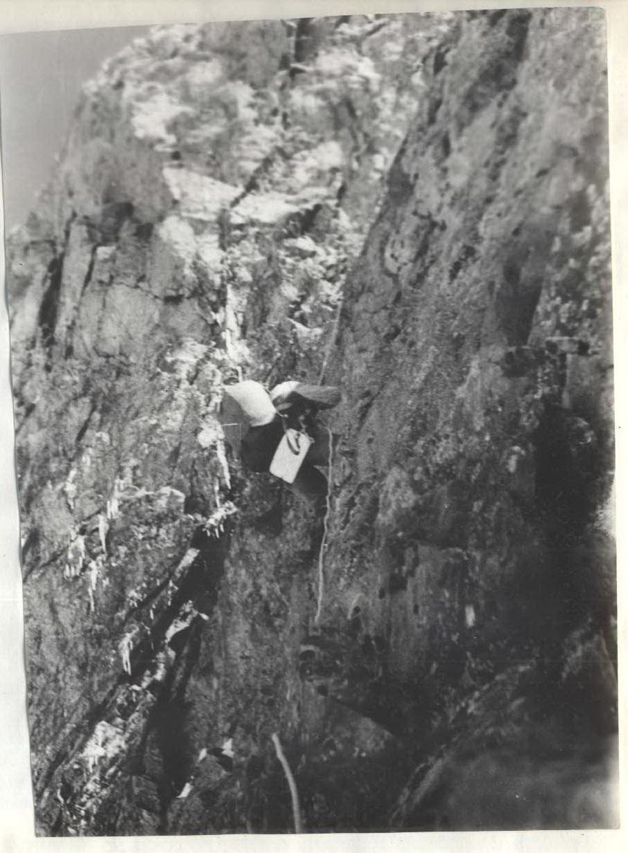 Photo 6. Traversing belays on the lower part of the wall on section R4–R5. August 26, 1985, 8:30.
 Photo 7. First ascent (route processing) of the upper part of the wall on section R4–R5. August 25, 1985, 17:00.
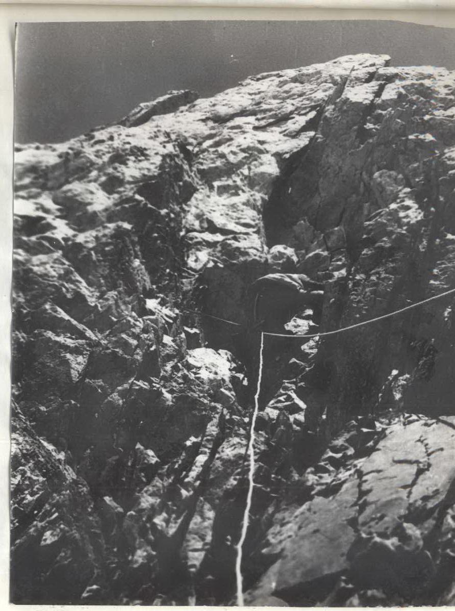 Photo 8. First ascent (route processing) of the internal corner on section R5–R6. August 25, 1985, 18:00.
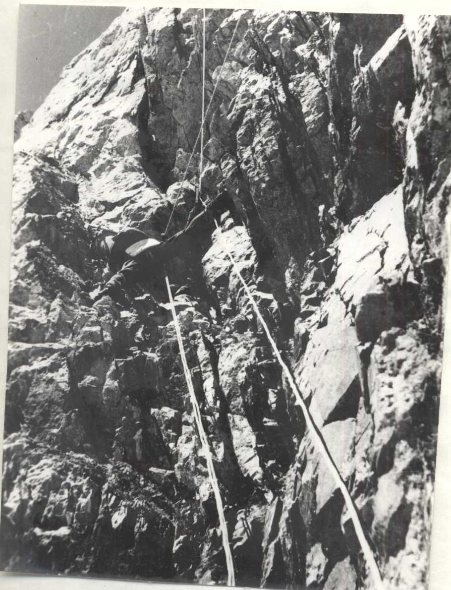 Photo 9. Traversing belays on the internal corner on section R5–R6. August 26, 1985, 11:00.