
ASCENT DOCUMENT
First Ascent Category — TECHNICAL CENTRAL CAUCASUS MAIN CAUCASUS RANGE USHBA PLATEAU
USHBA MALAYA 4309 m VIA NORTH-EAST RIDGE
Proposed difficulty category: 3B
Height difference — 200 m (from the plateau)
Length of 5A category difficulty sections — 5 m
Average steepness — 55° (of key sections)

| Pitons driven | Rock |
| For belaying | 19 |
| For creating ITO | 1 |
Travel time on the route — 7.3 hours (from plateau to plateau). No overnight stays on the route.
Leader: ANDREEV Nikolay Foteevich 1st sports category Members:
- AKIMOV Nikolay Aleksandrovich 1st sports category
- VIDYAKIN Vladimir Anatolyevich 1st sports category
- YAZOVSKIKH Gennadiy Stepanovich Candidate Master of Sports
Coach: LEVIN Mikhail Semenovich Master of Sports of the USSR
Date of the first ascent — July 29, 1978
FEDERATION OF ALPINISM CHELYABINSK REGION, 1980
- group's route.
- A. Sidorenko's route 1937 2B category via 3rd control point, NE ridge.
- N. Kiyanitса's route 3A category via 3rd ridge. (descent route)
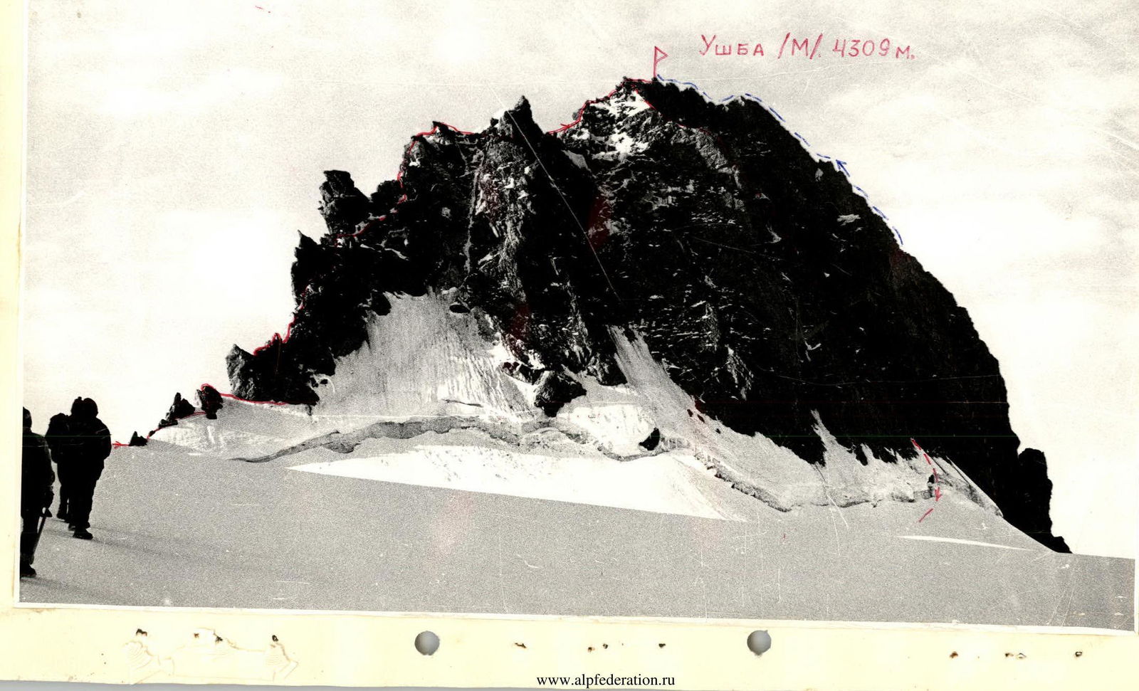
TABLE OF MAIN CHARACTERISTICS OF THE FIRST ASCENT ROUTE: Ushba (M.) via NE ridge
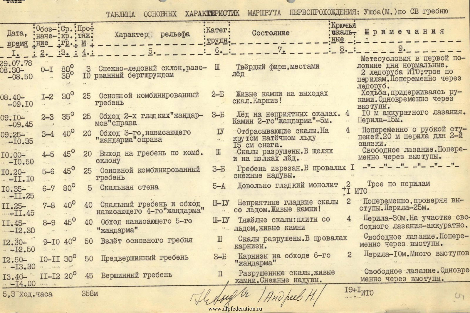
| Date, time | Notation: Avg.: Pro÷ nie FDM | kr.:tyazh. | Terrain characteristics | Categ: diff | Condition | Rock pitons | Notes |
|---|---|---|---|---|---|---|---|
| 29.07.78 | |||||||
| 08:30–08:50 | R0–R1 80° 30° | 3 | Snow-ice slope, broken by a bergschrund | 3 | Hard firn, ice in places | Weather conditions normal in the first half of the day. 2 ice axes ITO; three on the rope. Alternating through ice axe. | |
| 08:40–09:10 | R1–R2 30° 25 | Main combined ridge | 2B | Live rocks on rock outcrops. Cornice! | Walking, holding on with hands. Simultaneously through ledges. | ||
| 09:10–09:45 | R2–R3 35° 25 | Bypassing 2nd smooth "gendarme" on the right | 3B | Ice on unpleasant rocks. 2nd "gendarme" chimney – 5 m. | 4 | 10 m of careful climbing. Rope protection–15 m. | |
| 09:25–10:35 | R3–R4 40° 20 | Bypassing 3rd overhanging "gendarme" on the right | 4 | Shedding rocks. On steep adhesive ice 15 cm of snow. | 4 | Alternating with step cutting. 20 m rope protection for the 2nd rope team. | |
| 10:00–10:50 | R4–R5 45° 20 | Exit to the ridge on a combined slope | 3 | Rocks are destroyed. Ice in crevices and on ledges. | Free climbing. Alternating through ledges. | ||
| 10:20–11:10 | R5–R6 45° 25 | Main combined ridge | 3B | Ridge is cut. Snow drifts in depressions. | 1 | —"— —"— —"— —"— | |
| 10:35–11:25 | R6–R7 80° 5 | Rock wall | 5A | Quite smooth monolith | 2 | Three on the rope | |
| 11:25–11:45 | R7–R8 40° 40 | Rock ridge and bypassing the overhanging 4th "gendarme" | 3–4 | Unpleasant smooth rocks with ice. Live rocks! | Alternating, checking ledges. Rope protection–25 m. | ||
| 11:45–12:30 | R8–R9 45° 40 | Bypassing the overhanging 5th "gendarme" | 3–4 | Heavy rocks: slabs with ice, live rocks | 4 | Rope protection–30 m. On the section of free climbing – carefully. | |
| 12:30–12:50 | R9–R10 40° 50 | Rise of the main ridge | 3 | Rocks are destroyed. Cornices in depressions. | Free climbing. Alternating through ledges. | ||
| 12:50–13:30 | R10–R11 30° 50 | Pre-summit ridge | 3B | Cornices on the bypass of the 6th "gendarme" | 2 | Rope protection–10 m. Many ledges | |
| 13:40–14:00 | R11–R12 20° 45 | Summit ridge | 2 | Destroyed rocks, live rocks. Snow drifts. | Free climbing. Simultaneously through ledges. | ||
| 5.3 travel h | 358 m | 19 + 1 ITO |
NOTES TO THE "TABLE OF MAIN CHARACTERISTICS"
- Column "1" indicates: start time of the section by the first person in the first rope team and end time of the section by the last person in the second rope team. Groups of 3rd and 2nd categories should NOT rely on this time.
- The "Table" does not reflect the ascent to the Ushba Plateau, which can be done either by the steps of the western serac (between Ushba and Eastern Shkhelda) or by the northwestern serac between Eastern Shkhelda and Shurovsky Peak. These sections have been described many times; moreover, every year, and even during the season, the ice terrain changes significantly.
- During the first ascent, the group from the base camp near the Dolra River (see "Map") climbed to the "Bolshevik" bivouac in 6 hours, and on the next day, July 29, from 5:00 to 8:30, they traversed lightly the western serac and the Ushba Plateau (using the tracks of the reconnaissance duo G. Berdyugin—G. Yazovskikh from July 23, 1980). The descent from the summit of Malaya Ushba via the 2B category route to the Ushba Plateau was made from 14:30 to 16:30. Overall, the route took more than 12 hours ("Bolshevik"—summit—"Bolshevik").
- The route was proposed to the group by the head of the Chelyabinsk regional higher mountaineering courses, Comrade LEVIN M.S., who deviated in 1958 from the 3rd overhanging "gendarme". At the beginning of the R3–R4 section, a rappel piton left by him was found, which was removed by the group as a souvenir. No signs of other groups were found along the entire length of the northeast ridge until the R11–R12 section.
CLASSIFICATION PROPOSALS
Overall, the route is psychologically very tense and technically more laborious than known 3B category routes, such as:
- Peak Kirova ("Ala-Archa");
- Sarykol (Adyr-Su valley);
- Peak Aristova (Malaya Almatinka valley).
The northeast ridge of Malaya Ushba (R0–R12) itself already exceeds the concentration of difficulties of 3B category routes on:
- Peak Manshuk Mametova (Malaya Almatinka valley);
- Peak Spartakiada ("Ala-Archa").
But it's still not possible to request 4A category for it — North Ushba is nearby with its "cushion"...
Therefore, the group requests to include the route they completed in the Classification Table as:
- Ushba (M.) 4309 m, 3B combined via NE ridge N. Andreev, 1978.
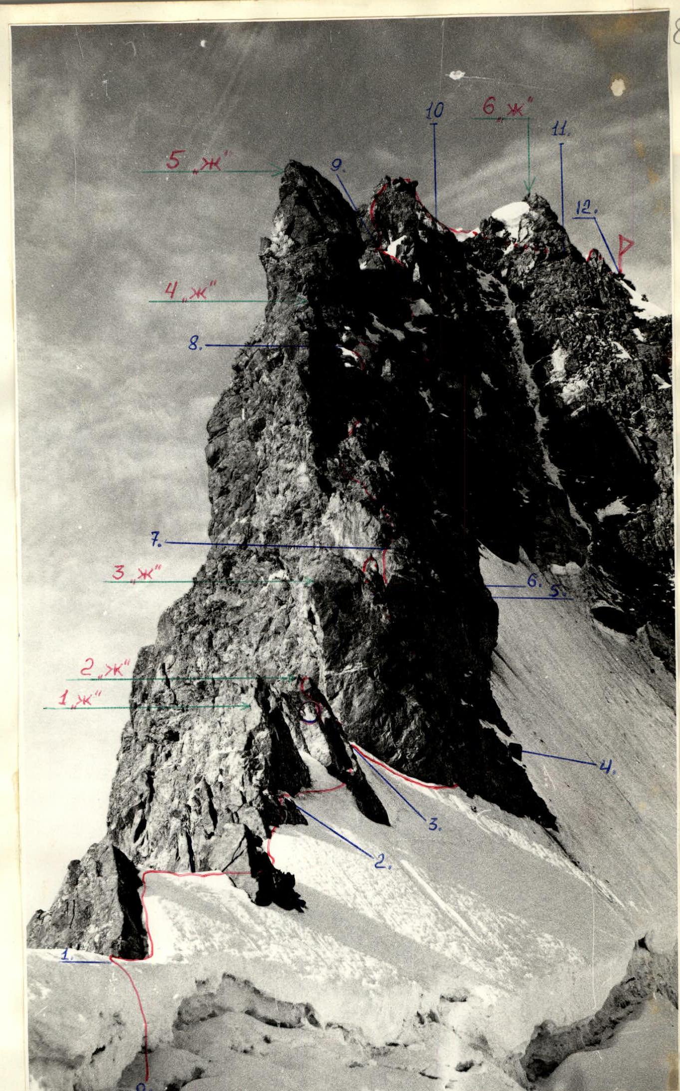
Photo #3. Northeast ridge of Ushba (M.). Facade.
Section R0–R9 photos #3; 6; 7.
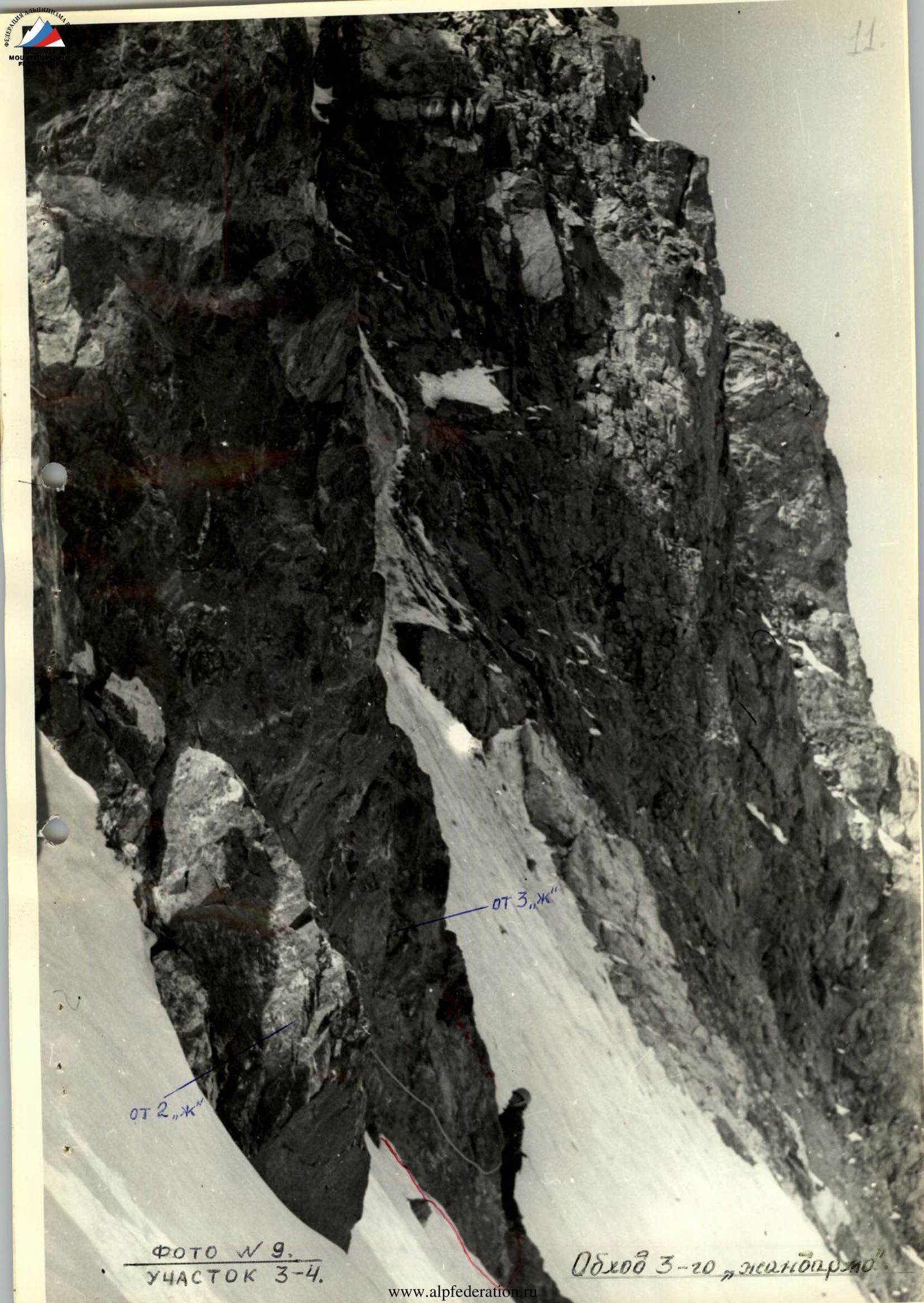
Photo #9. SECTION R3–R4. Bypassing the 3rd gendarme.
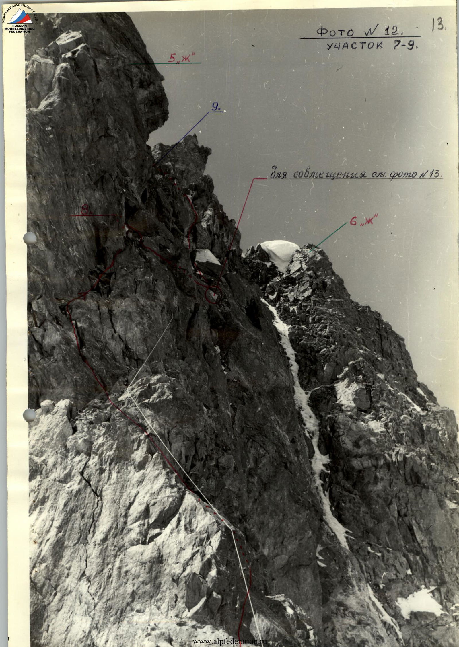
Photo #10. SECTION R6–R7. (for alignment. Passing the Wall.)
Photo #11. SECTION R7–R8. Bypassing the 4th overhanging "gendarme" with smooth rocks.
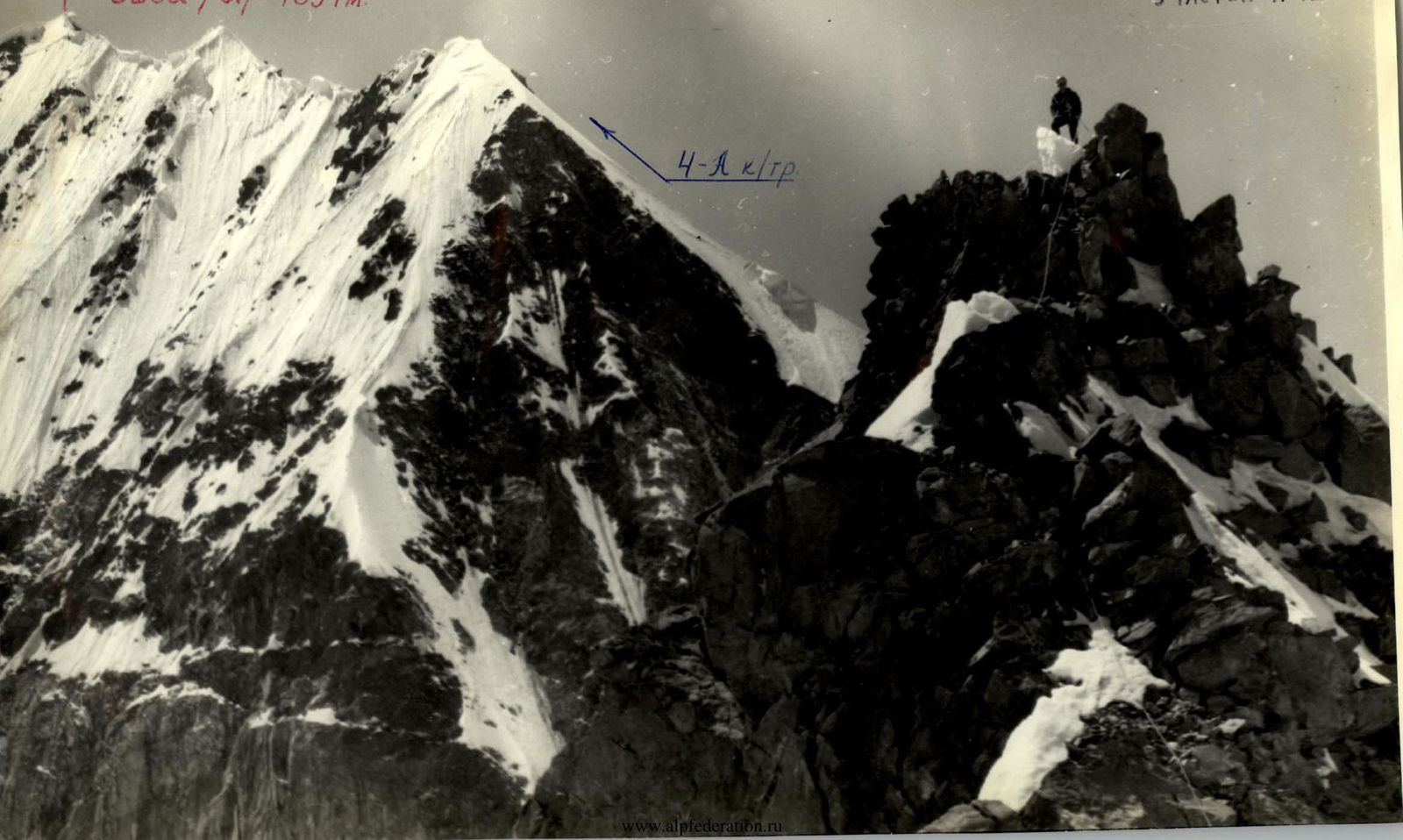
Photo #12. SECTION R7–R9. (for alignment see photo #13.)
Ushba (N.) 4694 m
Photo #17. SECTION R11–R12.

Comments
Sign in to leave a comment