I. Climbing Passport
- Climbing category — technical.
- Climbing area — Central Caucasus.
- Peak — Ullu-Kara via the left part of the north-eastern wall (first ascent).
- Difficulty category: 5B, approximate.
- Route characteristics:
- total length — 1545 m.
- height difference — 1300 m.
- average steepness — 47°.
- length of sections with 5.6 difficulty category — 500 m
- length of the icy part — 1175 m.
- Pitons hammered:
| For belaying | For creating RTO | |
|---|---|---|
| Rock | 26 | 1 |
| Ice | 97 | - |
| Bolt | 1 | - |
- Number of climbing hours — 16 h 30 min.
- Number of bivouacs and their characteristics — one (semi-sitting).
- Surnames, I.O. of the leader, participants and their qualification: Simakov A.N. CMS (leader) Gorodetsky E.M. MS Yazykov V.I. CMS Dmitrenko V.I. 1st sports category
- Team coach — Gorodetsky E.M.
- Dates of departure to the route and return to the base camp:
- departure July 31, 1981.
- return August 1, 1981.
2. Description of the approach to the route
Fig. 1 shows a map of the climbing area. From the "Adyl-Su" alpine camp, ascend along the road to the "Jan-Tugan" alpine camp, then move along the trail to the "Green Hotel" bivouac. From here, turn right, ascend to the right-bank moraine of the Bashkarinsky glacier, then cross the glacier in the direction of the southern slopes of Cheget-Kara peak. Then ascend left-up to the bivouac on the "Green shoulder". A bivouac is possible. From here, approach the north-eastern wall of Ullu-Kara peak along a snowy-icy slope. From the "Green Hotel" bivouac, 2 h 30 min walking.
3. Organizational and tactical climbing plan
3.1. Organizational plan of the ascent
The team, having experience of joint climbs over a number of years, underwent a training cycle at the "Adyl-Su" alpine camp, during which classes were held on various types of mountain relief, new equipment was tested, and acclimatization and sports climbs were made on routes close to the technical complexity of the declared route: (Aviazi peak — 4B category, Volnaya Ispaniya peak 5B category, Ushba Traverse 5A category, along the bastion of the South-West wall — 6 category).
3.2. Tactical plan of the ascent
The tactical plan for climbing Ullu-Kara peak via the left part of the north-eastern wall was built taking into account the characteristics of the route and the individual qualities of the team members. The route was observed for several years, as well as immediately before the ascent. The observation group was located at the "Green Hotel" bivouac and had a 12× binoculars and a "Karat/M" radio station. Communication between the team, the "Adyl-Su" alpine camp and the observation group was carried out using the "Karat-M" radio station (Team call sign — "Almaz-12"). Overall, the tactical plan looked as follows:
- July 30, 1981. Departure from the "Adyl-Su" alpine camp and approach to the "Green Hotel" bivouac. Visual observation of the route.
- July 31, 1981. Departure from the bivouac, approach to the start of the route, passage of sections R1–R15 (Fig. 4, Table 1), arrangement of a bivouac on a rocky bastion.
- August 1, 1981. Departure from the bivouac, passage of sections R16–R23, ascent to the summit, descent via route 3A to the upper plateau of the Kashkatash glacier. Bivouac on the plateau.
- August 2, 1981. Departure from the bivouac on the plateau and return to the "Adyl-Su" alpine camp.
Possible bivouac locations on the route:
- at the beginning of section R1 (Fig. 4, 2) under a rocky island,
- at the end of sections R8 and R11 — in the bergschrund,
- on the ledges of sections R15–R20,
- on the summit of Ullu-Kara.
The ascent plan was agreed with the training department of the "Adyl-Su" alpine camp and with the head of the camp's rescue team.
Table 1. Main characteristics of the ascent route
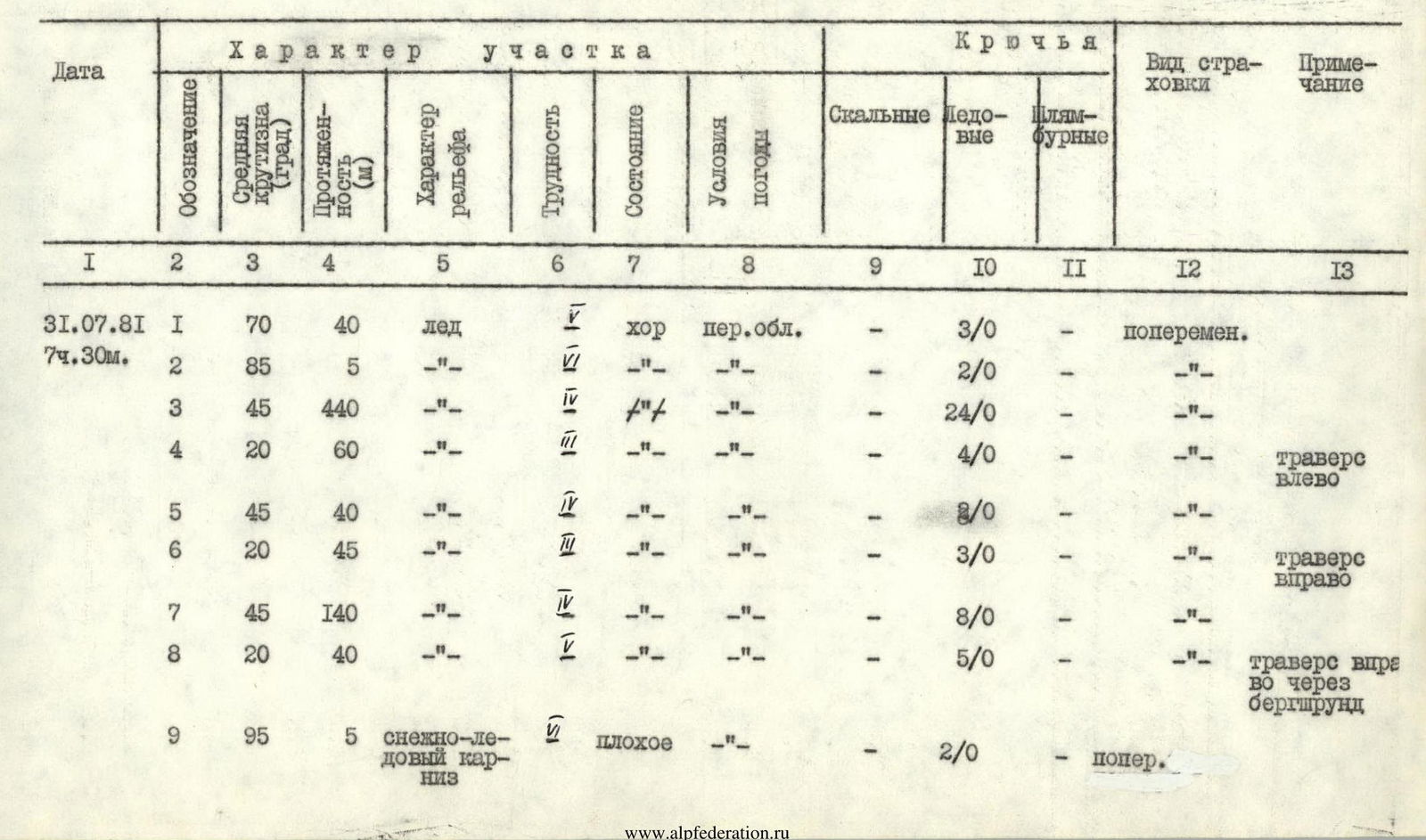
| Date | Designation | Average steepness (degrees) | Length (m) | Terrain type | Difficulty | Condition | Weather conditions | Rock | Ice | Bolt | Belay type | Note |
|---|---|---|---|---|---|---|---|---|---|---|---|---|
| July 31, 1981 | R1 | 70 | 40 | ice | √P | good | partly cloudy | - | 3/0 | - | alternate | |
| R2 | 85 | 5 | -"- | √P | -"- | -"- | - | 2/0 | - | -"- | ||
| R3 | 45 | 440 | -"- | IV | -"- | -"- | - | 24/0 | - | -"- | ||
| R4 | 20 | 60 | -"- | III | -"- | -"- | - | 4/0 | - | -"- | traverse left | |
| R5 | 45 | 40 | -"- | IV | -"- | -"- | - | 8/0 | - | -"- | ||
| R6 | 20 | 45 | -"- | III | -"- | -"- | - | 3/0 | - | -"- | traverse right | |
| R7 | 45 | 140 | -"- | IV | -"- | -"- | - | 8/0 | - | -"- | ||
| R8 | 20 | 40 | -"- | IV | -"- | -"- | - | 5/0 | - | -"- | traverse right through bergschrund | |
| R9 | 95 | 5 | snowy-icy cornice | IV | poor | -"- | - | 2/0 | - | simultaneous | ||
| R10 | 60 | 160 | snow, firn | IV | poor | partly cloudy | - | - | - | simultaneous via ice axe | ||
| R11 | 20 | 30 | ice | II | -"- | -"- | - | 5/0 | - | simultaneous | traverse right across bridge through bergschrund | |
| R12 | 80 | 10 | -"- | IV | -"- | -"- | - | 3/0 | - | -"- | ||
| R13 | 70 | 80 | -"- | II | -"- | -"- | - | 4/0 | - | -"- | ||
| R14 | 20 | 40 | -"- | IV | good | -"- | 2/0 | 4/0 | - | -"- | traverse right | |
| R15 | 50 | 40 | varied wall | 4 | broken rocks | -"- | 2/0 | - | - | ledges | ||
| 16:30 | Bivouac semi-sitting, 9 climbing hours | 4/0 | 1/0 | Site 1 K.T. | ||||||||
| August 1, 1981, 8:00 | R16 | 70 | 75 | wall | 4 | broken rocks | sunny | 1/0 | - | - | simultaneous via ledges | |
| R17 | 80 | 45 | wall | 5 | monolithic rock | -"- | 3/0 | - | - | -"- | ||
| R18 | 90 | 5 | wall | 5–6 | -"- | -"- | 3/1 | - | - | -"- | ||
| R19 | 50 | 120 | wall | 3 | partly icy | -"- | 3/0 | - | - | -"- | ||
| R20 | 50 | 40 | -"- | 5 | -"- | -"- | 4/0 | - | - | -"- | ||
| R21 | 50 | 180 | ice | IV | icy | -"- | - | 15/0 | - | alternate | ||
| R22 | 20 | 20 | -"- | II | -"- | -"- | - | 3/0 | - | -"- | ||
| 15 h 30 min | R23 | 40 | 120 | snow | IV | poor | -"- | - | 5/0 | - | belay via ice axe | |
| Total: | 26/1 | 97/0 | 1 |
4. Explanations for the route diagram (Fig. 5), compiled using the UIAA symbol system
The lower part of the route (sect. R1–R3) passes through the left part of a pronounced ice gully. There are steep ice walls, passable on the front teeth of crampons with an ice axe and ice hammer, and crevices in which one can take shelter from a possible ice fall. The average steepness of this part is 53°. Then 60 m traverse left and 40 m ascent to the exit under a giant ice wall with a large hole (sect. R4–R5). From here, crossing the gully, exit under the South wall of the second bergschrund. It passes in the right part through a small snowy cornice (first person extracts backpack), after which along a snowy-icy slope (belay via ice axe and ice screws, average steepness 43°, sect. R6–R7) exit under the bergschrund with a large snowy bridge-plug. The bergschrund is traversed by traversing right-up (sect. R10–R11), then ascent along an icy slope 80 m (average steepness 60°, sect. R12), and 40 m icy traverse to exit onto slopes of the "ram's forehead" type. From here 40 m ascent up to a bivouac. Here a site for a tent was laid out and a control cairn was hung on a bolt. Then 35 m ascent up rocky terrain to an inclined site, then along a narrowing chimney to exit under a rocky wall (sect. R16). Many loose rocks. The wall is passed up-right and ends with a 5 m vertical slab (there are cracks) (sect. R17–R18). At the top there is a site for a possible bivouac. Then 120 m along rocks of medium difficulty to exit under a 40 m slab with smoothed ledges (difficult climbing), partly filled with ice, leading to an icy slope (sect. R19–R20). Along a steep slope on very hard ice, such as icing, ascent 180 m and 20 m traverse left onto an icy "knife" (sect. R21–R22). Along the icy "knife" exit to the upper ridge (sect. R23). Before the ridge, approximately 20 m away, there is a transverse, widening downwards crevice, passable across a snowy bridge. Then along a simple gentle summit ridge to the exit of rocks (summit, control cairn). Descent via route 3A category to the upper plateau of the Kashkatash glacier.
5. Provision of the team with equipment and food
Based on the icy nature of the ascent, taking into account data from многолетних observations of the route, in order to ensure safety and speed of passage of the route, appropriate group and individual equipment was selected. The main characteristics of the equipment are summarized in Table 2. The main requirements for the equipment were:
- maximum technical efficiency
- guaranteed reliability
- minimum weight
- ease of use
Some of the equipment used was manufactured during the preparation for the ascent. Experimental equipment from VISTI and the Leningrad "Sovyerf" was also used, including rock and ice hammers, ice axe, ropes. Particular attention was paid to the selection and preparation of ice equipment. The team used 14-tooth crampons of foreign and domestic manufacture. Based on the results of the ascent, there are no significant complaints about the equipment.
6. Conclusion
In accordance with the recommendations of the Presidium of the FA USSR on the preferred choice of icy and snowy-icy routes as objects of ascent in the 1981 season, the team of the MGS DSO "Lokomotiv" for participation in the Championship of the CS "Lokomotiv" chose an icy-snowy route along the north-eastern wall of Ullu-Kara peak.
Excellent physical, technical and psychological preparation of the team members, their многолетняя cohesion, as well as good condition of the route and weather allowed to carry out the passage of the route at a good pace, dictated also by safety requirements.
In the future, this route, which, in our opinion, fully corresponds to the 5B category, can be recommended to groups and pairs with high snowy-icy preparedness and corresponding effective ice equipment.
When developing a tactical plan, it is necessary to take into account the following risks:
- Possibility of rock-ice avalanches in the lower part of the route (sect. R1–R14)
- Avalanches
- Collapse of cornices from the summit ridge in the upper part (sect. R21–R23), especially in conditions of limited visibility.

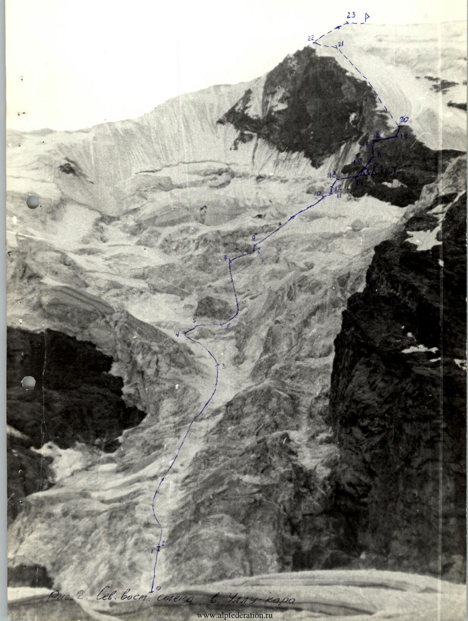 Fig. 2. North-eastern wall of Ullu-Kara peak.
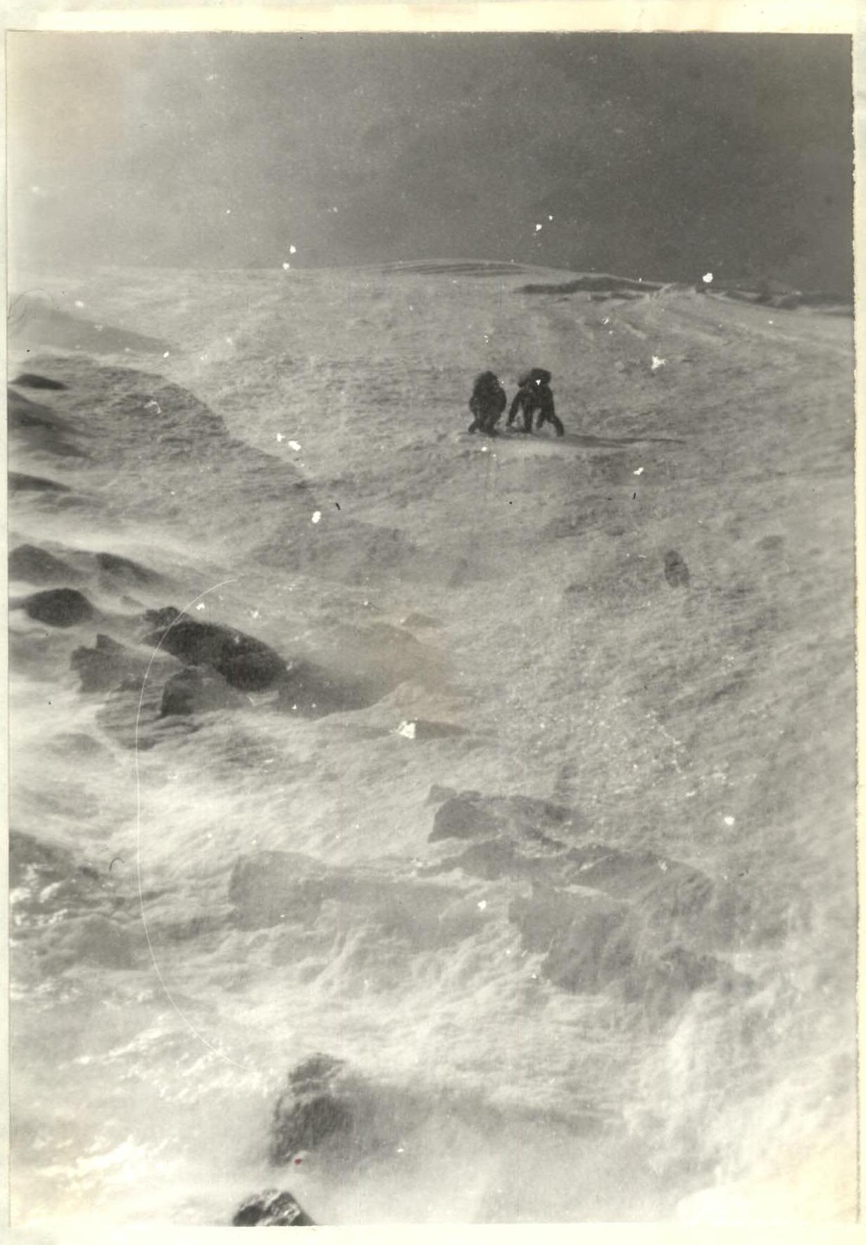 Fig. 12. First rope team at point R20 (sect. R21).
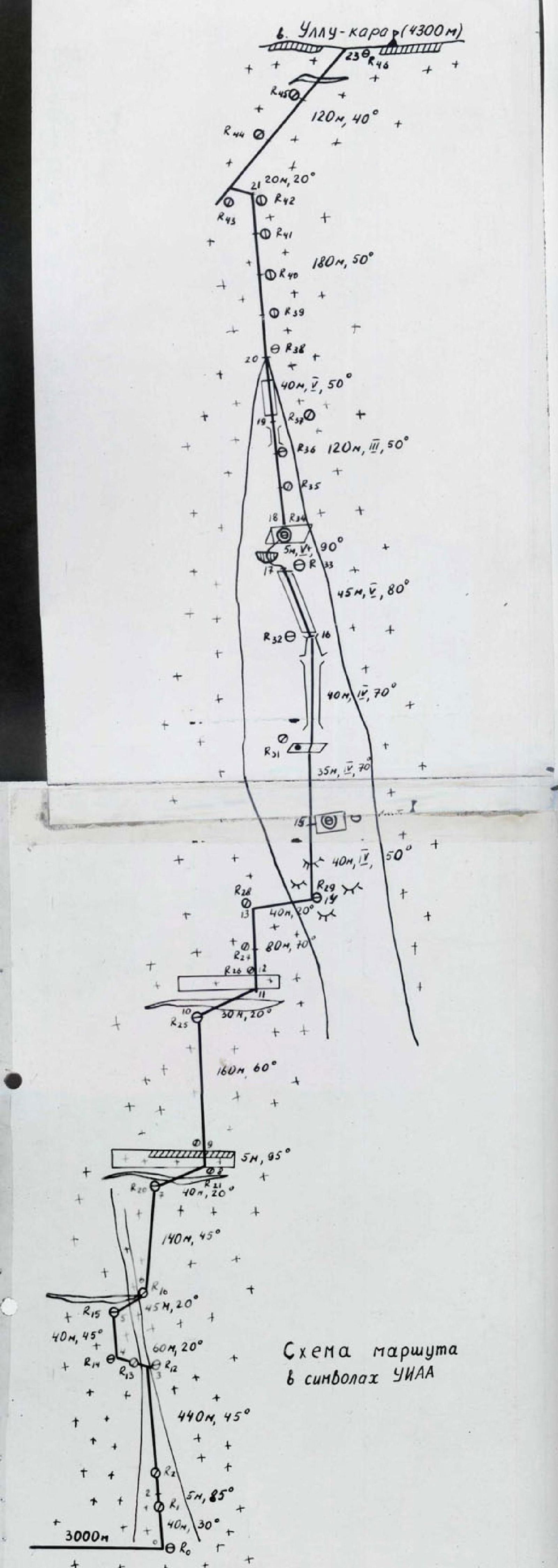 Route diagram in UIAA symbols.
 Fig. 13. Second rope team on the "knife" (sect. R22).