Central Caucasus
ULLUKARA 4037 m via the northwest wall buttress. (Tentatively — 2B cat. difficulty.)
- Temirov Anatoly Magometovich 1st class
- Temirov Mukhamed Magometovich 1st class
Bauman MSTU Sports Club.
Geographic Description of the Climbing Area
The ULLUKARA peak is located in the Main Caucasian Range, between the peaks of Bashkara to the east and Pik Volnaya Ispaniya to the west. This section of the Main Caucasian Range is in the Baksan Valley area. The Baksan Valley area is one of the most visited regions by climbers in the Caucasus. The alpine camps located in the area, good roads, and numerous beautiful peaks make this area attractive to climbers. Many climbing routes of varying difficulty have been laid out in this region. The most beautiful peaks of the Caucasus, such as Ushba, Shkhelda, Chatyn, Volnaya Ispaniya, and many others, are located in this part of the Central Caucasus. The Ullukara peak is situated in the upper Adylsu gorge. A good automobile road leads from Nalchik to the "Djan-Tugan" alpine camp.
From the "Djan-Tugan" alpine camp to the Kashkatash glacier plateau, a good trail is laid out. Further, the path goes along the Kashkatash glacier to the ascent to its upper plateau.
The ULLUKARA peak is a huge rocky massif covered with a powerful ice cap. It rises with black walls above the Kashkatash glacier. To the northeast from Ullukara, a short northern spur extends with the peaks of Pik Germogenova and Chegetkara. Between the peaks of Ullukara and Pik Germogenova lies a glacier.
The weather in this region is usually good, with short, rare periods of bad weather. Fogs are common, coming from the south through the Kashkatash pass.
The path to the start of the route goes from the "Djan-Tugan" alpine camp up the road of the Adylsu gorge. After 300 m, turn right from the road and descend along the trail to a temporary wooden bridge located above the confluence of the Kashkatash river into Adylsu. Here, cross Adylsu and follow the trail, which initially goes through a flat forest, then steeply ascends to the old left-bank moraine of the Kashkatash glacier, and further along the moraine ridge, exit to the sites. From the sites, descend to the Kashkatash glacier and ascend along the side of the glacier. The ice fall is bypassed on the left under the slopes of Ullukara, and exit to the upper plateau of the Kashkatash glacier under the beginning of the northwest wall buttress.
Description of the Route Passage by Days and Characteristics of Sections
August 16, 1976. At 12:00, we left the overnight stay under the "Ryжие скалы" (Red Rocks), passed the ice fall, and ascended to the upper plateau of the KASHKATASH glacier. At 15:00, we stopped for the night under the northwest wall buttress. At 16:00, without backpacks, we went to scout the route. At 16:30, we approached the beginning of the route and started ascending to the ridge. At 17:10, we passed the R0–R1 section. The 40 m section is a narrow, interrupted shelf, with a site for two at the end, difficult climbing; piton belay. At 18:00, we passed the R1–R2 section. The 40 m section goes first along a wide internal angle, turning into a chimney, with a plug in the upper part. Climbing is complex, with piton belay. At 18:10, we reached the ridge. At 18:30, we descended to the camp. On sections R0–R1 and R1–R2, we left hung ropes (80 m). Overnight stay on the plateau.
The next day, August 17, 1976, we got up at 4:00, started on the route at 6:00, the weather was satisfactory. At 7:00, we were on the ridge. We descended 30 meters down to the snow. We passed the R3–R4 section at 10:30. The section is a steep snow slope about 300 m long. At the end of the section, there are about 15 meters of ice, which we passed with step-cutting. The R4–R5 section is a snow slope, not difficult, about 160 m, passed while moving simultaneously, and approached the base of the wall. A good site for an overnight stay, we built a cairn. We rested for 15 minutes and began ascending the wall.
Wall sections:
- Section R5–R6: at the beginning, there is a 4-meter vertical wall with few holds, then 15 meters along the talus shelves of medium difficulty.
- Section R6–R7: 60 meters along difficult rocks with piton belay and exits along a smooth 4-meter slab.
- Section R7–R8: an internal angle filled with flow ice, 12–14 m long, with an exit to a large oblique shelf. Very difficult climbing with piton belay.
- Section R8–R9: from the shelf, traverse right beyond the bend along rocks of medium difficulty.
- Section R9–R10: an inclined wall 25 m with few holds, passed directly with piton belay.
- Section R10–R11: a chimney with an overhanging (2–2.5 m) entrance. Climbing is complex, with piton belay. At the entrance, ladders were used.
- Section R11–R12: traverse left 8 m along difficult rocks, then 6–8 m up to a shelf. Difficult climbing with piton belay.
- Section R12–R13: a vertical wall 20 m with few holds. The key point of the route. Passed with free climbing using artificial holds, without backpacks. Backpacks were pulled up. Above the wall, there is a site for one and 3 meters higher — another site.
- Section R13–R14: from the sites, a not clearly defined ridge 20 m follows. Rocks of medium difficulty. On the saddle under the wall — the 2nd control cairn. We passed section R13–R14 at 17:00.
- Section R14–R15: from the control cairn, traverse left 8 m along a small shelf along the base of a small (2 m) overhanging chimney. The chimney is passed with ladders.
- Section R15–R16: from the chimney, 30 m up along difficult rocks to a small shelf, from the shelf traverse 8 m right to a small saddle, and descend 2–2.5 m under the beginning of an internal angle with flow ice. Climbing is difficult with piton belay.
- Section R16–R17: an internal angle filled with flow ice, 12–14 m long, with an exit to a large oblique shelf. Very difficult climbing with piton belay.
- Section R17–R18: from the oblique shelf, 10 m directly up along a difficult wall with few holds.
- Section R18–R19: a chimney narrowing at the top, 20 m long, with an overhanging entrance (2 m), passed with ladders. From the chimney, an exit to a large site under the northern ridge. Overnight stay is possible. Climbing is very complex.
- Section R19–R20: from the right edge of the site, an internal angle 15 meters to a shelf beyond the wall's bend. In the internal angle — flow ice. Climbing is complex with piton belay.
- Section R20–R21: from the shelf, descend 2–3 m, traverse right 8 m along difficult rocks to the base of a not clearly defined angle, then along the angle 15 m up — ascent to the ridge. Climbing is complex with piton belay.
- Sections R21–R22, R22–R23: first along a rocky, then snowy ridge, exit to the snowy dome of Ullukara peak. Before exiting to the dome — the 3rd control cairn. We were at the control cairn at 20:40. At 21:00, we reached the dome and set up for the night.
On August 18, we got up at 4:00, began descending at 6:00 along the 3rd category difficulty.
Characteristics of the wall: The wall part of the route (sections R5–R21) is 330 m long. The overall steepness of the wall is 65°. There are no sites for a tent on the wall. A sitting overnight stay is possible. The wall is composed of hard rocks and surprisingly has few "live stones". The weather during the ascent was satisfactory, sometimes foggy, from 17 to 18 — light, insignificant snow. On August 18, the weather was excellent.
Description of the route to the ULLUKARA peak via the northwest buttress of the northwest wall.
From the "Djan-Tugan" alpine camp, move up along the road of the Adylsu gorge. After 300 m, turn right from the road and descend along the trail to a temporary wooden bridge located a little above the confluence of the Kashkatash river and the Adylsu river. Here, cross the Adylsu river and follow the trail, which initially goes through a flat forest, then steeply ascends to the old left-bank moraine of the Kashkatash glacier, and further along the moraine ridge, exit to the sites on the talus at the end of the moraine. From the sites, descend to the Kashkatash glacier and along the left side of the glacier (crevasses) ascend up. The ice fall is passed on the left under the slopes of Ullukara. Caution is necessary: rockfalls and icefall collapses are possible from the slopes of Ullukara.
The northwest buttress of the northwest wall of Ullukara peak descends to the beginning of the upper plateau of the Kashkatash glacier. From the plateau, crossing the bergschrund, ascend along a steep snowslope 40 m towards the talus shelves below a large vertical chimney on the right side of the buttress. Then along the talus shelves 40–50 m directly up to a site under a smooth wall. Here, a good site for an overnight stay can be arranged. From the "Djan-Tugan" alpine camp — 6–7 hours.
From the site, descend down left 5–8 m and approach the beginning of a narrow inclined shelf leading up-left along the wall. Along the narrow (20–30 cm), sometimes interrupted, inclined shelf left-up along the wall — 40 m to a small site for two (piton belay; difficult climbing).
From the site, first along a wide, turning into a chimney, internal angle 40 m. In the upper part of the chimney — a plug. Complex climbing, piton belay. Then along the talus shelves 20 m — exit to the ridge.
Further movement is along the ridge, bypassing all the gendarmes of the ridge on the left side. The rocks of the ridge are simple, sometimes of medium difficulty. It is possible to ascend under the wall along a steep snowslope on the left side of the ridge.
The ridge is 250–300 m long. Further, the ridge turns into talus shelves, and along them directly up to a gendarme at the base of the wall. After 100–120 m, we approach under a 3-meter wall.
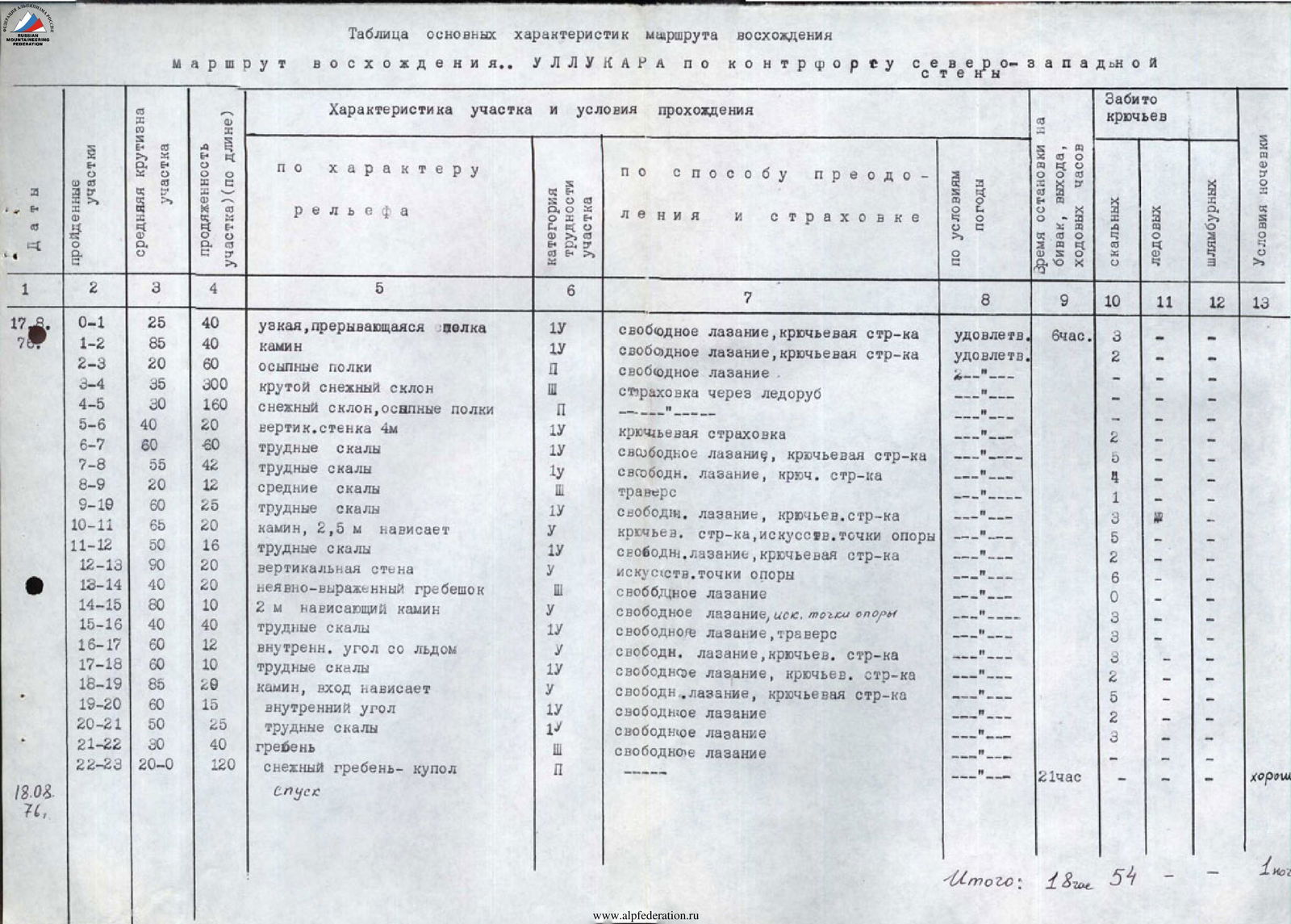
Table of Main Characteristics of the Ascent Route
Ascent route: ULLUKARA via the northwest wall buttress.
The brown wall is bypassed on the right, further 12–15 m directly up under a gendarme at the foot of the wall. The gendarme is bypassed on the right along a 4-meter difficult wall and exits to a saddle between the gendarme and the wall. Further directly up 15–20 m and approach the base of the Northwest wall.
Here is a site for an overnight stay and the 1st control cairn. From the sites under the buttress — 6–7 hours.
Along the wall directly up 60 m along difficult rocks with piton belay and approach under a smooth 4-meter wall. The wall is bypassed on the left, then up-right along inclined slab-like rocks 6–8 m. From here directly up 30 m to a shelf under the wall, then traverse right 10–12 m beyond the bend and approach under an inclined wall. (Notable place: on the left side of the wall, there is a large vertical chimney 1.5–2 m wide with steep walls).
Along the center of the inclined wall directly up 25 m (difficult rocks, piton belay) under the base of an inclined 20-meter chimney leading left. The entrance to the chimney overhangs, it is advisable to have ladders. Further along the complex chimney left-up to a small shelf (piton belay). From the shelf, traverse left about 8 meters under the base of a vertical angle-chimney, turning into a cleft in the upper part. First along the right side of the chimney 6–8 m directly up to a small shelf under the base of the wall, then 20 m of very difficult climbing along a vertical wall (piton belay — the key point of the route) to a site above the wall. From the site along the left side of a not clearly defined ridge 20 m directly up to a saddle under the wall. Rocks of medium difficulty. On the saddle — the 2nd control cairn. From the 1st control cairn — 4–5 hours.
From the saddle, traverse left along a small shelf 7–8 m under the base of a small overhanging chimney (2 m, ladders). The chimney is passed directly and further directly up along rocks of medium difficulty 25–30 m to a small shelf. From the shelf, traverse right 8–10 m to a small saddle, then descend a little (2–2.5 m) and approach under the beginning of a small internal angle with flow ice. Along the angle directly up 10–12 m to a small oblique shelf (difficult climbing, icy rocks). From the left side of the large shelf directly up along a difficult wall 10–12 m to the base of an oblique chimney (piton belay), the entrance to the chimney overhangs 1.5–2 m, passed with ladders, and further along the chimney up 10–12 m to a small site under the northern ridge. Overnight stay is possible. From the right edge of the site right-up along a small internal angle to a shelf beyond the wall's bend. From the shelf, descend right down 2–3 m, then traverse along the wall right (piton belay) to a not clearly defined internal angle leading to the northern ridge. Along the angle up to the ridge 12–15 m and further along the ridge 40 m to the beginning of the snowy ridge. Here — the 3rd control cairn. Further along the border of snow and rocks 80 m to the base of the snowy dome. Further ascent to the dome and traverse the dome towards the ridge — 3rd control cairn.
From the 2nd control cairn — 4–5 hours. Descent along the route 3rd category difficulty.
| Dates | Passed Sections | Average Steepness of Section | Length of Section (by length) | Characteristics of Section and Passage Conditions | Category of Difficulty of Section | Method of Overcoming and Belay | Weather Conditions | Time of Stop for Overnight Stay, Exit, Hiking Hours | Number of Pitons Driven | Overnight Stay Conditions |
|---|---|---|---|---|---|---|---|---|---|---|
| 17.08.1976 | R0–R1 | 25° | 40 m | narrow, interrupted shelf | 1 | free climbing, piton belay | satisfactory | 6 hours | 3 rock | |
| R1–R2 | 85° | 40 m | chimney | 1 | free climbing, piton belay | satisfactory | ||||
| R2–R3 | 20° | 60 m | talus shelves | 2 | free climbing | |||||
| R3–R4 | 35° | 300 m | steep snow slope | 2 | belay via ice axe | |||||
| R4–R5 | 30° | 160 m | snow slope, talus shelves | 2 | ||||||
| R5–R6 | 40° | 20 m | vertical wall 4 m | 1 | piton belay | 2 | ||||
| R6–R7 | 60° | 60 m | difficult rocks | 1 | free climbing, piton belay | 5 | ||||
| R7–R8 | 55° | 42 m | difficult rocks | 1 | free climbing, piton belay | 4 | ||||
| R8–R9 | 20° | 12 m | medium rocks | (traverse) | 1 | |||||
| R9–R10 | 60° | 25 m | difficult rocks | 1 | free climbing, piton belay | 3 | ||||
| R10–R11 | 65° | 20 m | chimney, 2.5 m overhang | 1 | piton belay, artificial holds | 5 | ||||
| R11–R12 | 50° | 16 m | difficult rocks | 1 | free climbing, piton belay | 2 | ||||
| R12–R13 | 90° | 20 m | vertical wall | 1 | artificial holds | 6 | ||||
| R13–R14 | 40° | 20 m | not clearly defined ridge | 1 | free climbing | 0 | ||||
| R14–R15 | 80° | 10 m | 2 m overhanging chimney | 1 | free climbing, artificial holds | 3 | ||||
| R15–R16 | 40° | 40 m | difficult rocks | 1 | free climbing, traverse | 3 | ||||
| R16–R17 | 60° | 12 m | internal angle with ice | 1 | free climbing, piton belay | 3 | 1 | |||
| R17–R18 | 60° | 10 m | difficult rocks | 1 | free climbing, piton belay | 2 | ||||
| R18–R19 | 85° | 20 m | chimney, entrance overhangs | 1 | free climbing, piton belay | 5 | ||||
| R19–R20 | 60° | 15 m | internal angle | 1 | free climbing | 2 | ||||
| R20–R21 | 50° | 25 m | difficult rocks | 1 | free climbing | 2 | ||||
| R21–R22 | 30° | 40 m | ridge | free climbing | ||||||
| R22–R23 | 20° | 120 m | snowy ridge-dome | 2 | 21 hours | good | ||||
| 18.08.1976 | descent | 1 overnight stay | ||||||||
| Total: | 18 hiking hours | 54 pitons |