в. ULLU-KARA, 4302 m, 3rd cat. diff., complicated category, N. Popov's route, '34
From the "Djantugan" base camp, follow a good trail along the right (orographically) lateral moraine of the Kashkatash glacier. After passing the overnight spot near the "Red Rocks", descend to the glacier and traverse its gently sloping middle section, sticking to its left (in traverse direction) side.
At the beginning of summer, there are many hidden crevasses here. Approaching the upper icefall of Kashkatash (opposite the hanging glacier on the slope of Pik Germogenov), overcome its left (in traverse direction) side under the slope of Ullu-Kara. This section is hazardous due to possible rock and ice fall from the ridge wall above. By the end of summer, traversing the icefall becomes more difficult due to numerous crevasses.
After reaching the snow plateau above the icefall, traverse it to the right and ascend a low-angle slope, sticking to its right (in traverse direction) side, to reach the Kashka-Tash pass. From Djantugan, it takes 5-7 hours; descent from the pass takes 2-4 hours.
From the pass, ascend to the summit via a steep, not clearly defined ridge with fragile rocks. After passing two bivouac sites:
- the first one is 30 minutes walk from the pass,
- the second one is another 30 minutes further,
start ascending the main ridge. The path goes along a rocky ridge to the right (in traverse direction) of a couloir, then along the left (in traverse direction) side of a wide snow slope to a small talus, from there - through a narrowing couloir and a chimney.
The upper part of the ascent to the main ridge is the key section of the route and is done with rope protection.
After passing the first cairn on the rocks, ascend the firn (or ice at the end of summer) summit cap, bypassing a rock step to the right. Rock spikes and several ice screws on the route are desirable, especially at the beginning of steep slopes. The ascent from the pass to the summit takes 5-7 hours. Descent takes around 4 hours.
Possible overnight spots:
- Near the Red Rocks
- On the plateau below the ridge between Bzhedug and p. Volnaya Ispaniya (no water)
- On the Kashka-Tash pass or within 30-60 minutes walk above the ridge
Protection on the route is mainly through rock outcrops; protection spots need to be thoroughly checked - rocks are very fragile!!
| ㅇ | sect. | 1 Prot., m.! Cat. diff! |
|---|---|---|
| 0–I | I20 II | |
| I–2 | 80 | III–IV |
| 2-3 | 80 | III |
| 3-4 | 80 | III |
| 4-5 | 250 | III–IV |
| 5-6 | 200 | II–III |
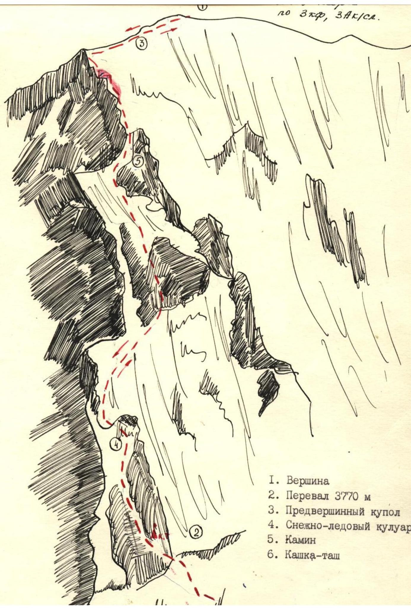 I.
Summit
I.
Summit
- Pass 3770 m
- Pre-summit dome
- Snow-ice couloir
- Chimney
- Kashka-tash