Ascent Log
- Class — rock.
- Elbrus region, Central Caucasus.
- Peak Trapezia (3740 m), via NW edge from the North Djan-kuat glacier.
- Difficulty category — 2A, first ascent.
- Route character: snow-ice, height difference from the glacier 300 m, steepness of the upper part 45°, length 180 m.
- Belay: when approaching the upper bergschrund — via ice axe, on the slope via ice screws, 17 pieces driven in total.
- Number of travel hours from the bivouac at "Green Hotel" 6–7 hours, descent from the summit — 2.5–3 hours.
- Group is training: Starikov G. A. — coach, Candidate for Master of Sports — Aksenov N. V., 2nd sports category — Bulatova M. I. — Kostin V. S. — Lozovoy S. M. — Fomin A. G.
- Training part of the sports camp "Djan-tugan", Candidate for Master of Sports of the USSR Laptev A. L.
- Ascent made on August 16, 1981.
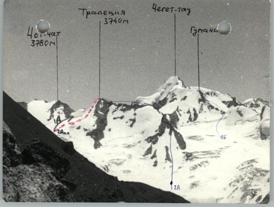
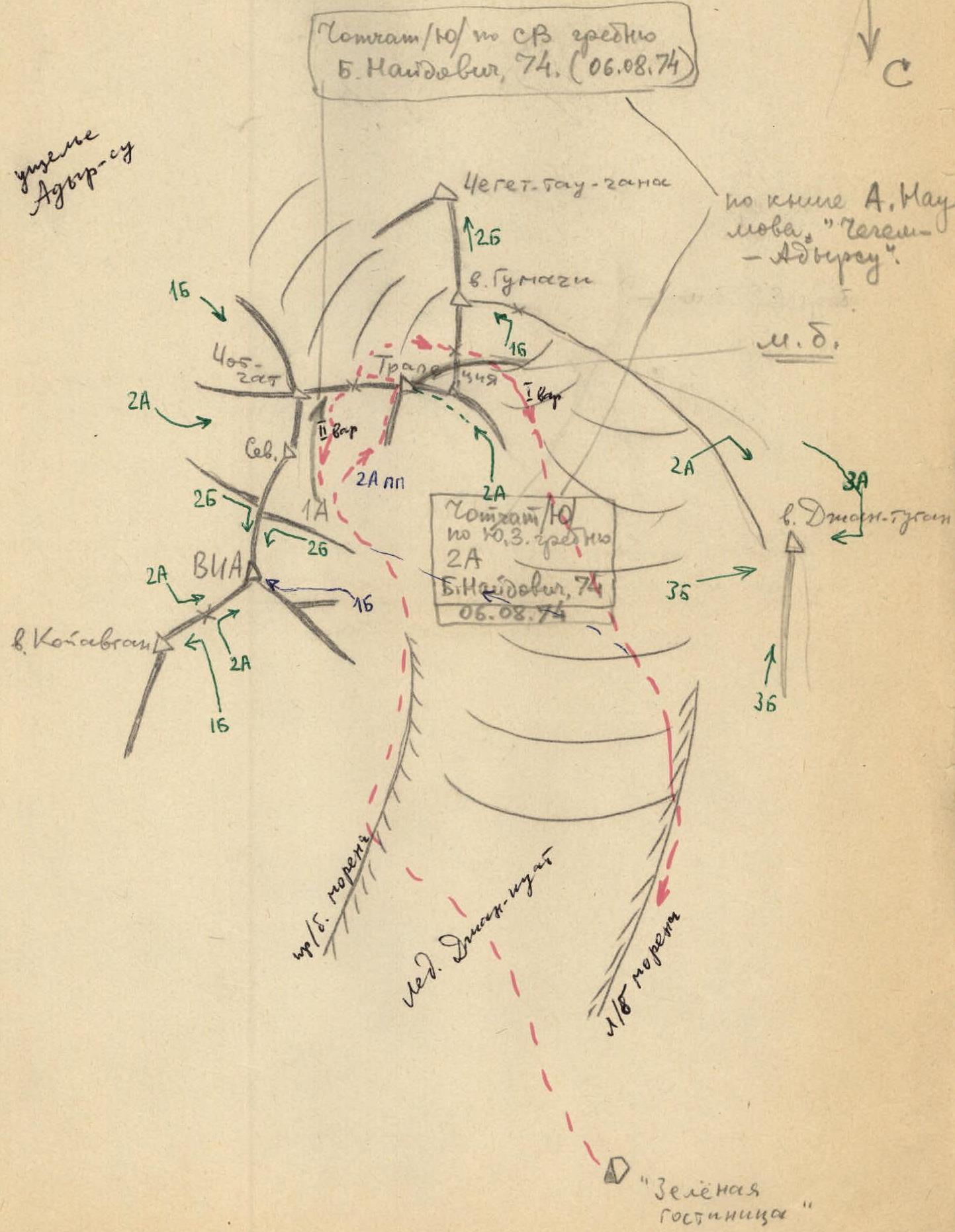 Peak Trapezia (3740 m) is a low but independent peak in the general ridge from V IA-tau peak to Cheget-tau-chany (see the map of the area, photos 1, 2). Previously, this peak was called Nameless (1974–1980), and in the book by A. F. Naumov "Chegem, Adyr-su..." it is listed as Chot-chat, South peak.
The peak of Trapezia divides the Djan-kuat glacier into its northern branch — under the ridges of V IA-tau, Chot-chat peaks and the northern peak of Trapezia. Between the S peak of Trapezia and Gumači peak is the well-known Gumači pass, through which lies a straightforward path from the Adyr-su gorge to Adyr-su.
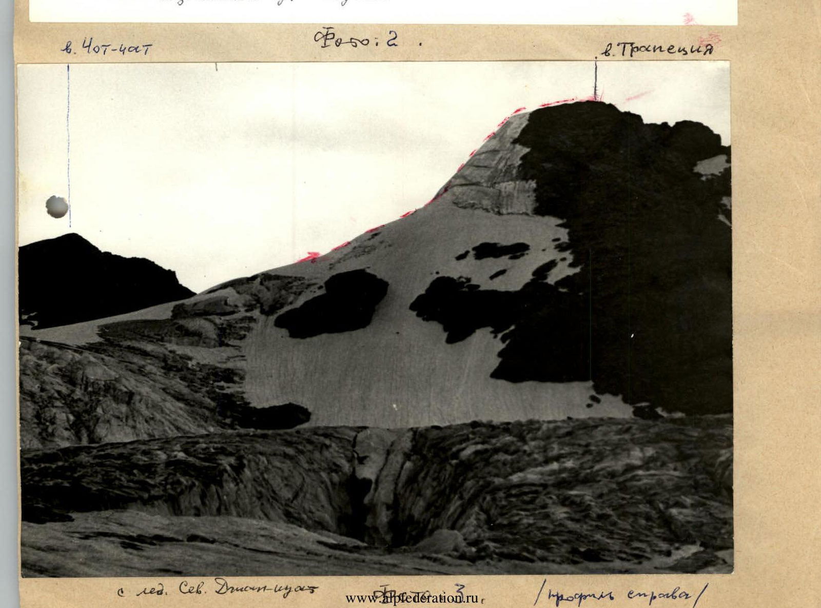
Just as logical a path, but slightly more technically challenging, goes through the pass between the peaks Chot-chat Main and Trapezia North (photo 2, map).
The proposed ascent route is not monotonous throughout the summer season: — icy in August, September; — snow-ice in July, August, but requiring, in some places, belay via ice screws due to shallow snow cover; — snowy in May, June, with the danger of "slab" avalanche when overloading the slope (snow lies on clean ice, steepness 45°, length 180 m), probably, during this period the route is not recommended.
From "Green Hotel" at 4:30, depart via the left-bank moraine to the Djan-kuat glacier, cross it to the right-bank moraine. Ascend along it to the end.
Organize rope teams, put on crampons. Descend to the right onto the glacier and ascend via snowfields (attention, crevasses). Keeping to the left side, sometimes with running belay, ascend to the plateau (photo 2). To R0 point — simultaneous movement — 3 hours.
Section R0–R1, R1–R2: — snow slope 20–30° — running belay via ice axe or snow stakes — careful crossing of bergschrunds
Section R2–R3: — right side of the edge — ice slope 45°, 180 m — rope team interaction (fixed ropes) with thorough screw belay
No rockfall was observed. From the end of the ice ascent, along the snow ridge 15 m to the summit cairn — 3 hours.
Descent from the peak Trapezia to the saddle with Chot-chat peak and further to the right to the Gumači pass or according to the II variant: descent to the plateau (thorough belay, fixed ropes — 80 m) to the start of the route and further down along your tracks, into the gorge — 2 hours.
The ascent route corresponds to 2A difficulty category, snow-ice, recommended for training purposes. Similar to the 2A category route on Trapezia peak in Uzunkol.
Report compiled by Starikov G. A.