Passport
- Technical category.
- Central Caucasus, Kykkyurtlyu gorge.
- Kykkyurtlyu peak, center of NW wall — 4623 m.
- 6B category route, Lukashvili 1981.
- Height difference — 860 m, wall section height difference — 580 m, wall section length — 640 m, average steepness of wall section — 87°.
- Pitons driven:
| Rock | Bolt | Chocks | Ice |
|---|---|---|---|
| 102 | 39 (37x) | 125 | 9 |
| 47 | 34 (33x) | 52 |
x — reuse of previously driven pitons.
-
Climbing hours — 54, days — 6.
-
Overnights: 1st — all in hammocks; 2nd — three in hammocks, one on a ledge; 3rd, 4th — four in a tent lying down; 5th — all in hammocks.
-
Team leader: Sushko S. E. — Candidate Master of Sports.
Team members:
- Burlushkin S. V. — Candidate Master of Sports
- Leonov P. G. — Candidate Master of Sports
- Grigorov A. V. — Candidate Master of Sports
-
Team coach: Porokhnya Yu. I. — Honored Master of Sports of the USSR.
-
Approach to the route: August 21, 1993.
Summit: August 26, 1993. Return: August 28, 1993.
General photo of the summit
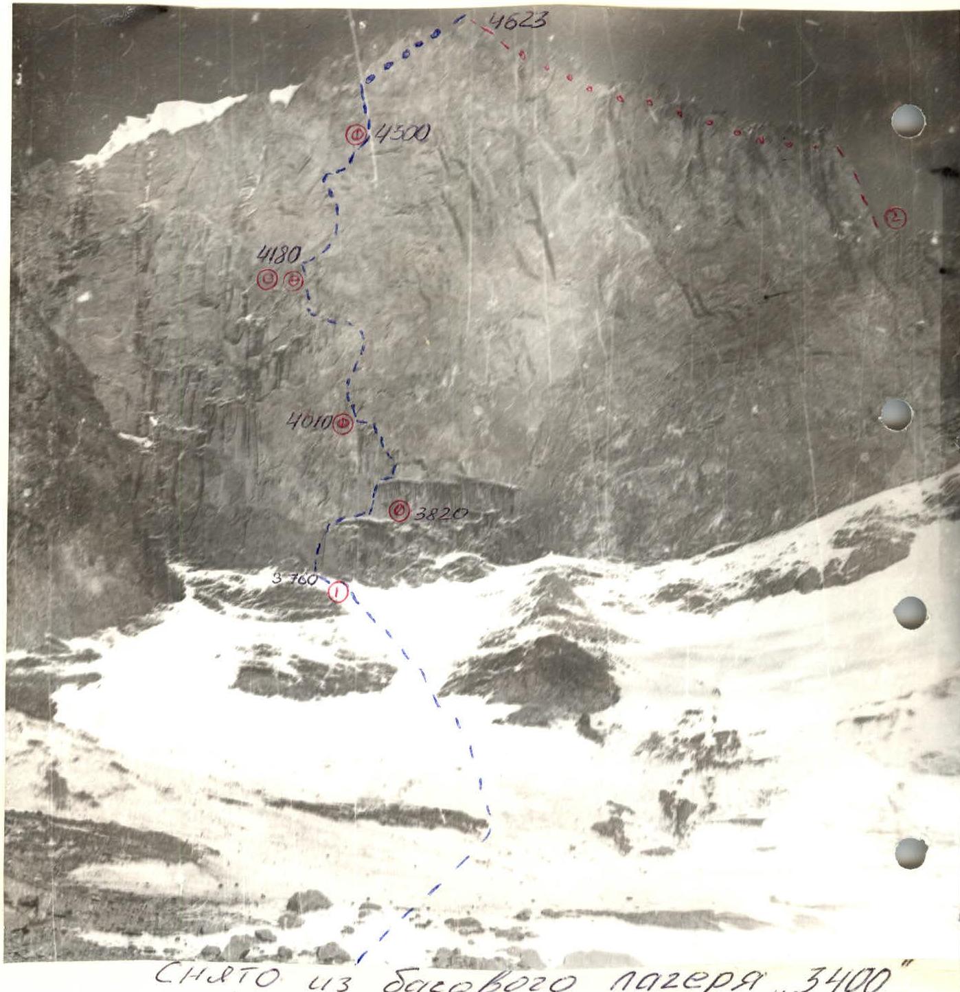
Taken from the "3400" base camp. August 20, 1993 at 17:00. Lens "Industar-23" F=11 cm. Distance to the object — about 1.5 km. 1 — Lukashvili route (1981). 2 — Y. Zhizhin route (1967).
Left wall profile
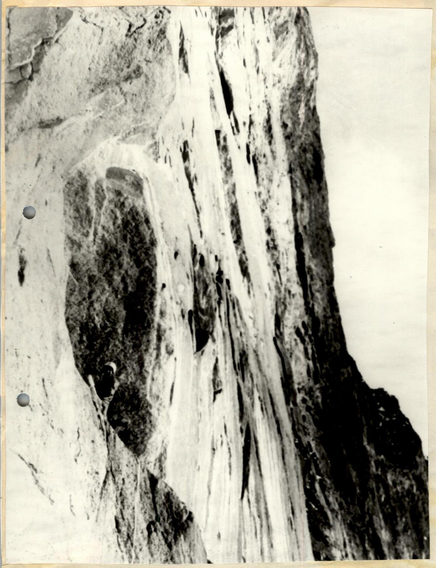
It is impossible to fully capture the route profile from the left due to the ridge extending left from the wall. Taken from R7–R8 route. Lens F=20 mm.
Right wall profile
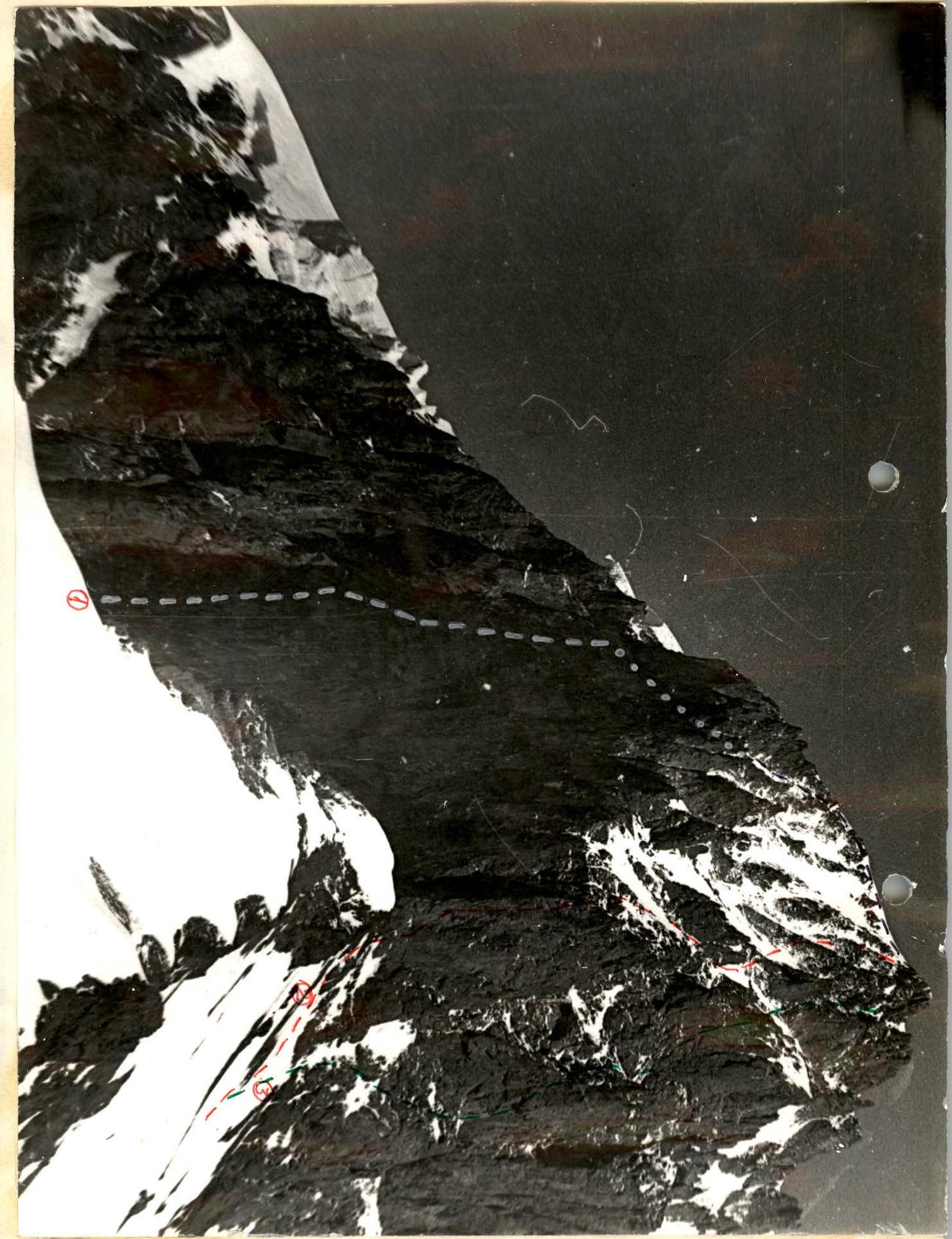
Taken by observers on August 24 at 15:00. Lens "Industar-23" F=11 cm. Distance to the object — about 800 m. 2 – Zhizhin route, 3 – Nekrasov route.
Team's tactical actions
The tactical ascent plan was developed after studying the reports by T. Lukashvili, V. Boyko, and V. Sklyarov. The study showed that it's not coincidental that the fastest wall crossing took 7 days. It's dangerous to rush on the West wall. Therefore, the tactical plan aimed to reach the summit on the sixth day, with an extra day for bad weather.
The tactical plan was executed with minimal deviations. Only the location of the first overnight stay was changed to a safer spot. The first day's program (distance covered) was fully achieved.
To ensure safe passage, several safety measures were implemented — the lead climber always used a double rope: foreign and domestic with a shock absorber. The wall was very cold, making it very challenging to lead in the morning. Therefore, a pre-processing tactic was constantly applied from intermediate bivouacs. The team took six ropes, allowing for upper belay ascents using jumar ascenders, even on the upper cornice belt (the first climber ascended on two ropes). One spare rope was used by the last climber for safe traverses with subsequent rope retrieval. Three backpacks were transported using a well-practiced American method, tied to the harness. No rucksack pulling was done. The possibility of separate overnight stays was considered, so a stove and gas burner with a set of cartridges were taken.
All bivouacs were under an overhang, in places protected from rockfall. While the front pair processed the route, the bivouac was made comfortable for proper rest.
Establishing communication with the base and coordinating with the observation and support group was crucial for safety. The support group spent four days under the wall in the base camp, observing. After the team reached the upper cornice belt, making descent impossible, the support group moved to the 5A Naugolny route. In case of emergencies, they could have provided assistance by descending from the summit.
The two groups maintained communication via "Lastochka" radio for six days. The support team also had a "Karat" radio, which maintained constant communication with the "Shkhelda" alpine camp.
The teams rotated leads every day. The most challenging aspect of the wall was undoubtedly the upper cornice belt. Modern climbing equipment was used to overcome it. The tactic of pre-processing was also applied here. The team left the bivouac only after pre-processing 130 m of the wall, including 90 m of the cornice belt.
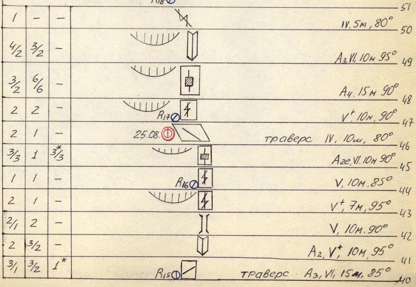
Route diagram in UNAA symbols
Total for August 22: pitons — 43, climbing hours — 9.
- R0: A2, V1, 20 m, 95°
- V, 15 m, 75°
- V, 10 m, 85°
- R1 (22.08): A3, V, 20 m, 95°
- R6: Traverse IV, 15 m, 80°
- R8: V+, 15 m, 85°
- R10: A2, V, 25 m, 90°
Total for August 21: pitons — 56, climbing hours — 9.
- R5: A3e, 5 m, 100°
- R: A3, V, 10 m, 90°
- R: A1e, V1, 5 m, 80°
- R4: A3, V, 15 m, 90°
- R3 (21.08): A, V, 15 m, 85°
- R0: V, 20 m, 85°
- IV, 20 m, 65°
- Snow-ice slope, steepness from 20° to 50°, length ~1000 m.
Total for August 24: pitons — 48, climbing hours — 9.
- R40: A2V1, 10 m, 85°
- R39: A3V1, 10 m, 90°
- R38: A2e, 5 m, 105°
- R37: A2e, 15 m, 95°
- R36: A4, 4 m, 85°
- R35: A2e, 8 m, 110°
- R34: A2e, V1, 9 m, 100°
- R33: A2e, 14 m, 110°
- R32: A4, 3 m, 85°
- R31: A2e, 6 m, 100°
Total for August 23: pitons — 71, climbing hours — 11.
- R30: Traverse V, 8 m, 90°
- R29: A3, V, 30 m, 80°
- R28: V+, 5 m, 95° (23.08–24.08)
- R27: V, 20 m, 80°
- R26: A3V1, 25 m, 95°
- R25: Traverse V, 15 m, 80°
- R24: V, 20 m, 85°
- R23: A4, 2 m, 100°
- R22: V+, 5 m, 90°
- R21: IV, 15 m, 80°
- R20: A4e, 25 m, 105°
- R19: A4e, 25 m, 105°
Total for the ascent: pitons, chocks — 275, climbing hours — 54.
| Rock | Chocks | Bolt | Ice |
|---|---|---|---|
| 102 | 125 | 39 | 9 |
| 47 | 52 | 34 |
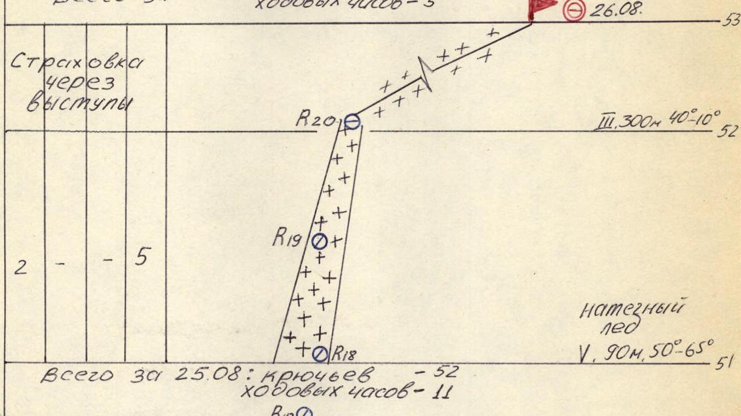
Total for August 26: climbing hours — 5.
Belay via rock outcrops.
- R20: III, 300 m, 40°–10° (26.08)
- R19
- R18: flow ice V, 90 m, 50°–65°
Total for August 25: pitons — 52, climbing hours — 11.
- R18: IV, 5 m, 80°
- R17: A3V1, 10 m, 95°
- R16: A4, 15 m, 90°
- R15: V+, 10 m, 90°
- R14 (25.08): Traverse IV, 10 m, 80°
- R12: A2e, V1, 10 m, 90°
- R11: V, 10 m, 85°
- R10: V+, 7 m, 95°
- R9: V, 10 m, 90°
- R8: A2, V+, 10 m, 95°
- R7: Traverse A3V1, 15 m, 85°
Route description by sections
The route up the West wall of Kykkyurtlyu peak is unique in its complexity:
- great steepness
- significant length of sections with negative inclination
- large height difference
- lack of convenient bivouac sites and water on the route
- presence of belts with unstable rock
- low temperature on the wall due to its location in a zone of heavy glaciation
All this series of facts validates that the route corresponds to the highest 6B category.
The route can be conditionally divided into 5 belts:
- Steep ice slope (sect. R0–R1)
- Vertical monolithic rocks with small cornices (sect. R1–R28)
- Red-colored section with monolithic cornices (sect. R29–R46)
- Vertical, shattered granite rocks (sect. R46–R51)
- Ice-snow couloir and pre-summit ridge (sect. R51–R53)
One of the significant factors is the diversity of the wall's geological structure — alternating low-strength rocks with hard ones, requiring varied equipment. The presence of belts with weak rock demands extra caution during passage and attention to anchor point organization. Particular care is required when navigating the granite vertical belt (sect. R46–R51), where "live" granite lenses hang on smooth walls.
The assault camp was located on the Kykkyurtlyu glacier moraine. The ice slope, leading to the wall, started right from the tents.
Day 1, August 21, 1993 Section R0–R1. Steepness 30°–50°, length 1000 m, ice with a thin layer of snow in places. Section R1–R2. Steepness 65°, length 20 m, inclined slab with good crack pattern. Section R2–R3. Steepness 90°, length 20 m, vertical wall with a crack. Use of artificial aids (ITO), use of chocks and hard steel pitons. Section R3–R4. Steepness 85°, length 20 m, traversed in stemples. Section R4–R5. Steepness 60°, length 20 m, traverse right, oblique ledge, complicated by snow and ice on the ledge. Organization of bivouac under an overhang in hammocks 5 m right of the belay station. Section R5–R6. Steepness 85°, length 15 m, vertical wall, difficult climbing with few friction holds. Use of ITO. Section R6–R7. Steepness 90°, length 10 m, internal corner with a crack. Use of ITO. Section R7–R8. Steepness 60°, length 15 m, traverse right, inclined slab. Section R8–R9. Steepness 90°, length 15 m, vertical internal corner left of the cornice. Use of ITO. Section R9–R10. Steepness 80°, length 5 m, slab with an oblique crack left. Use of ITO. Section R10–R11. Steepness 90°, length 10 m, vertical chimney, extremely difficult climbing with few holds. Use of ITO. Section R11–R12. Steepness 100°, length 5 m, overhanging wall. Use of ITO. Entrance to a niche, good belay spot.
Day 2, August 22, 1993 Section R12–R13. Steepness 90°, length 25 m, wide, well-defined internal corner with small cracks. Climbing is extremely difficult with few cracks. Use of ITO. "Skyhooks" and small hard steel pitons are used. Section R13–R14. Steepness 85°, length 15 m, poorly defined internal corner, free climbing with great tension. Section R14–R15. Steepness 80°, length 15 m, traverse along the wall left. The last climber goes on double ropes with rope retrieval. 1 control turret. Organization of bivouac under a cornice. Section R15–R16. Steepness 95°, length 20 m, overhanging internal corner, extremely difficult climbing. Use of ITO. Section R16–R17. Steepness 85°, length 10 m, internal corner turns into a chimney, very decomposed rocks, extremely careful climbing. Section R17–R18. Steepness 75°, length 15 m, smoothed inclined slab. Section R18–R19. Steepness 100°, length 20 m, poorly defined overhanging internal corner, many "live" rocks, extremely difficult climbing. Use of ITO.
Day 3, August 23, 1993 Section R19–R20. Steepness 100°, length 25 m, overhanging wall with a crack. Use of ITO. Climbed with great tension. Section R20–R21. Steepness 80°, length 15 m, oblique crack left leads to a platform for two people. Section R21–R22. Steepness 90°, length 5 m, vertical wall with minimal holds. Section R22–R23. Steepness 100°, length 2 m, cornice traversed using ITO. Section R23–R24. Steepness 85°, length 20 m, vertical walls are very decomposed, extremely careful climbing, diagonal movement left. Be cautious with perlon ropes, as they can dislodge rocks. Section R24–R25. Steepness 80°, length 15 m, traverse along the wall left, the last climber goes on double ropes with rope retrieval. Section R25–R26. Steepness 95°, length 25 m, wet overhanging chimney. Use of ITO. Extremely difficult climbing, rock pitons used. Section R26–R27. Steepness 80°, length 20 m, internal corner with many holds, "live" outcrops present. Organization of bivouac in a tent on a platform under the upper cornice belt. Section R27–R28. Steepness 95°, length 5 m, overhanging internal corner, climbed with great tension. "Skyhooks" used. Section R28–R29. Steepness 80°, length 30 m, vertical wall with an oblique crack, traversed diagonally left to right. Use of ITO. Section R29–R30. Steepness 90°, length 8 m, traverse right under the start of the large cornice belt.
Day 4, August 24, 1993 Section R30–R31. Steepness 100°, length 6 m, vertical overhanging wall. Use of ITO. Section R31–R32. Steepness 85°, length 3 m, vertical wall with a crack. Use of ITO. "Skyhooks" used. Section R32–R33. Steepness 110°, length 14 m, strongly overhanging cornice, climbed with great tension. Use of ITO. Section R33–R34. Steepness 100°, length 9 m, overhanging wall. Use of ITO. Section R34–R35. Steepness 110°, length 8 m, cornice climbed with great tension. Use of ITO. Section R35–R36. Steepness 85°, length 4 m, vertical crack. Use of ITO. Section R36–R37. Steepness 95°, length 15 m, cornice climbed with great tension. Use of ITO. Section R37–R38. Steepness 105°, length 5 m, strongly overhanging cornice climbed with great tension. Use of ITO. Section R38–R39. Steepness 90°, length 10 m, vertical wall with minimal holds and cracks. Diagonal movement left. Extremely difficult climbing. Use of ITO, "skyhooks" used. Section R39–R40. Steepness 85°, length 10 m, oblique crack in a vertical wall. Climbing left is extremely difficult. Use of ITO.
Day 5, August 25, 1993 Section R40–R41. Steepness 85°, length 15 m, very difficult traverse right with minimal cracks. Use of ITO. Section R41–R42. Steepness 95°, length 10 m, well-defined internal corner turning into a chimney. Use of ITO. Section R42–R43. Steepness 90°, length 10 m, chimney climbed in stemples. Section R43–R44. Steepness 95°, length 7 m, vertical wall with a crack. Section R44–R45. Steepness 85°, length 10 m, vertical wall with a crack climbed free. Section R45–R46. Steepness 90°, length 10 m, vertical wall, use of ITO. Rocks are very decomposed, climbing is extremely difficult, requires great caution. Section R46–R47. Steepness 80°, length 10 m, traverse along inclined slabs left. Organization of bivouac under an overhanging wall in hammocks. Section R47–R48. Steepness 90°, length 10 m, vertical wall with minimal holds and cracks. Climbed on friction. Section R48–R49. Steepness 90°, length 15 m, vertical wall with a crack turning into an internal corner. Use of ITO. Climbing is extremely difficult, rocks are heavily decomposed. Section R49–R50. Steepness 95°, length 10 m, overhanging internal corner. Use of ITO. Rocks are heavily decomposed, climbed with great tension. Section R50–R51. Steepness 80°, length 5 m, oblique crack leading to the start of the ice couloir.
Day 6, August 26, 1993 Section R51–R52. Steepness 50°–65°, length 90 m, steep narrow couloir with flow ice. Climbed on front points with two tools. Climbing is very tense. Section R52–R53. Steepness 40°, length 300 m. Snow-ice slope leading to the pre-summit ridge. Summit.
Descent via the 2B category route through the West shoulder of Elbrus peak, Khotyutau pass, Mir station, Azau village.
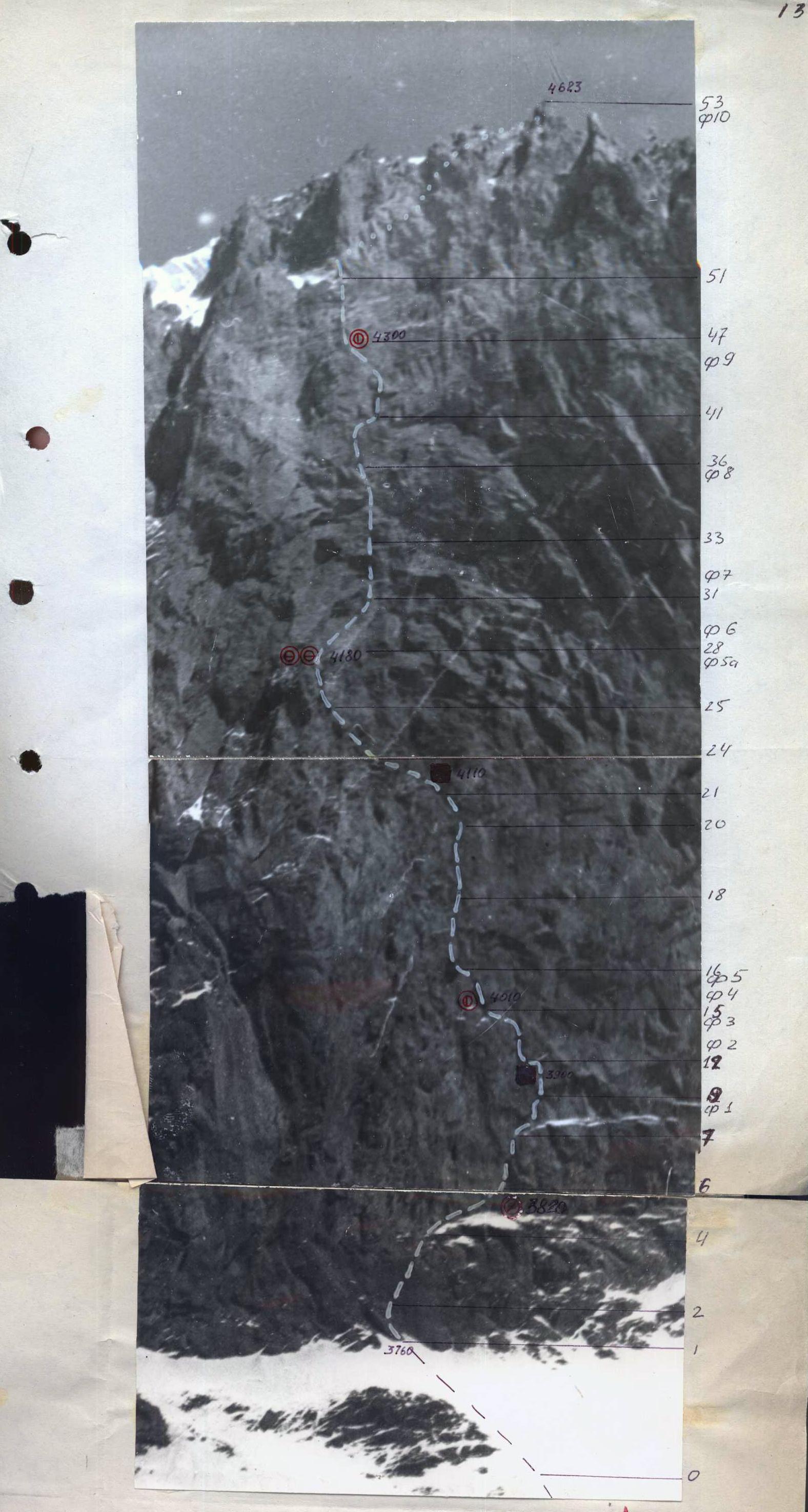
Technical photograph of the route taken from the "3400" base camp. Lens "Industar-23" F=11 cm. Distance to the object — about 1.5 km. Taken on August 21 at 15:00. F1–F10 — photo numbers.