The description is compiled based on materials from the training part of Ulutau a/l.
Description of the Approach to the Route
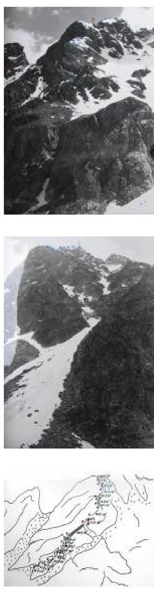
From the AGЛК "Jailyk", cross the bridge over the Adyr-Su river downstream. Behind the bridge, to the left near the source, a trail begins, going through the forest up the slope in the direction of the Jalovchat lake.
Climbing along the trail:
- Cross to the left (green) moraine, leading to the N. counterfort of the E. ridge in Koy-Avgan.
- Continue ascent along the moraine.
- The N. counterfort of the E. ridge is dissected by a large couloir in its lower part.
- Ascend along the green moraine until the upper part of the counterfort dissected by the couloir starts to overhang on the left.
- Here, turn left and ascend up the slope to the rocks of the counterfort, leaving the couloir to the right.
- The start of the route is in the middle (between two rocky spurs) of the lower part of the bastion, which is crowned with a rocky tooth and connected by a narrow ridge to the main part of the counterfort.
Attention:
- The couloir to the right is rockfall-prone.
- At the beginning of summer, with a large accumulation of snow to the left of the slope from the counterfort, there is a possibility of avalanches.
Explanation for the Scheme
The route consists of two parts. Initially, the movement occurs along the N. counterfort with an exit to the E. ridge, where it connects with the route along the E. ridge of category III complexity. Further movement occurs along the category III route to the summit. The scheme describes the 1st part of the route along the N. counterfort.
- 0,1 — destroyed rocks
- 1.2 — traverse to the right 10 m along the main shelf, to the left the path seems simpler, but after 30 m the rocks become although not very complex, but heavily smoothed, covered with moss and lichen; there are few cracks for organizing insurance; therefore, it is recommended to move to the right
- 4.5 — destroyed rocks with small monolithic sections
Control cairn on the talus shelf. From the control cairn, move along the shelf 40 m towards the couloir, and then turn left.
8.9 — movement along the right part of the counterfort — destroyed rocks. At the end, a narrow shelf, from which there is an ascent to the top of the bastion (tooth) and a descent 2 m to the jumper.
9.10 — ascent to a small gendarme, which is bypassed to the right with an exit to the main ridge of the N. counterfort. Here is the 2nd control cairn.
11.12 — destroyed ridge.
12.13 — sharp ascent on the ridge.
15.16 — movement along the ridge, try not to go to the right under the snow tongues, which can be hazardous (at the end of summer, there is an ice slope here).
17.18 — the ridge becomes gentle and wide; at this point, the route connects with the route along the E. ridge of category III complexity.
Taken from the website www.ullutau.ru↗ Kuznetsova Yulia