Report on the Ascent of Donguz-Orun via the North Face
Geographical Location and Sporting Characteristics of the Ascent Object
The peak Donguz-Orun (4,452 meters above sea level) is located in the Main Caucasian Range, between the Donguz-Orun pass and the Becho pass. To the west of Donguz-Orun lies the peak Nakra-Tau, essentially serving as a shoulder of Donguz-Orun.
Donguz-Orun, like Elbrus to its north, is characterized by significant glaciation. All three peaks of Donguz-Orun are covered by a powerful glacier, reaching thicknesses of 120–150 meters.
On the southern side, towards the Nakra valley, this glacier has natural, gentle slopes. However, on the north, northwest, and northeast, due to the steepness of the slopes forming the walls, the summit glacial shield breaks off with sheer drops. The ice is expended in these directions through ice avalanches, making the northern walls of Donguz-Orun highly dangerous to traverse.
The glacier on the peaks of Donguz-Orun is often referred to as the ice "cap" or simply "cap".
The peaks of Donguz-Orun have been visited by climbers multiple times, with several ascent variations available.
The most well-known route is the ascent via the northern ridge (4A category of difficulty), which is traversed annually by many climbing groups.
Furthermore, ascending Donguz-Orun from the west, along gentle ice and snow slopes (2B category of difficulty), is quite common. This route is also typically used for descending from the summit after ascending via the northern ridge.
Notably less frequent are ascents via two other routes:
- along the ridge from the east, from the direction of the Becho pass (4B);
- via the Markelov route, involving ascent to the northern ridge along its western slope (4B).
The ascent of Donguz-Orun via the northwest wall, accomplished by us, was a first ascent, despite numerous applications from various sports societies over the years. Below is a general characterization of the ascent route via the northwest wall.
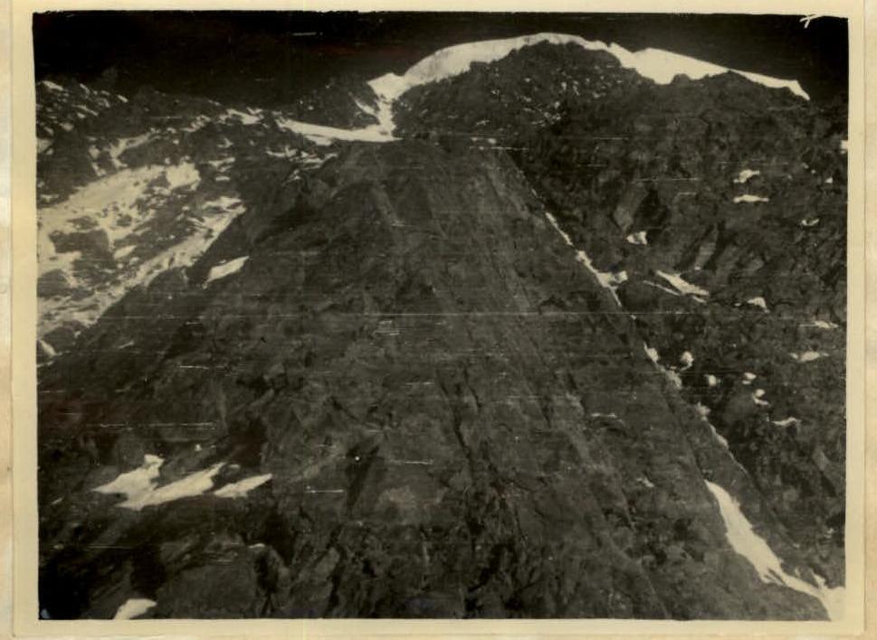
The total route length — the difference in height between the camp at the foot of the wall on the moraine (see photo) and the summit — is approximately 1,800 meters.
The entire route is characterized by a very high objective danger due to frequent ice avalanches and rockfalls.
The route can be divided into the following main sections (see photo, profile scheme, and detailed technical description of the route by sections):
- Transition across the glacier to the ice-scalar triangle;
- Overcoming the first scalar triangle;
- Transition across ice to the second scalar triangle;
- Advancement along the snowy ridge;
- Advancement along the not clearly defined scalar ridge;
- Ascent up a steep ice slope with step cutting, using crampons;
- Ascent along a destroyed scalar ridge with inclusions of superimposed ice;
- Ascent up an ice slope on crampons with step cutting;
- 200-meter ascent up rocks of medium to high difficulty;
- Overcoming a hanging ice cornice and reaching the "cap".
These sections vary in technical difficulty. The most challenging section of the route is the 15-meter hanging ice cornice, overcoming which required nine hours of continuous, strenuous work using ladders hung from ice screws. Also particularly difficult were:
- two sheer scalar walls (25 and 30 meters high) on the first scalar triangle;
- two 5-meter ice walls before the second scalar triangle, made particularly challenging by the presence of superimposed ice on the rocks;
- the transition across the glacier from the overnight camp on the moraine to the bergschrund;
- the traverse across a 25-degree ice slope above the first scalar triangle.
However, even this section — the transition from the first to the second scalar triangle — requires movement with belay. On all other sections of the route, continuous alternating belay was necessary — through outcrops, scalar and ice screws, and via ice axe.
Several sections of the route were deemed more feasible with the aid of lightweight rope ladders with metal steps, suspended from scalar or ice screws. This applied to all walls and ice overhangs, as well as overcoming various internal corners and steep slabs along different parts of the route.
Assessing the route's overall difficulty and objective danger, the group considers the route to be category 5B.
Signatures: Khergiiani (M. Khergiiani) Kakhiiani (I. Kakhiiani) Adyr-Su-Shkhelda. September 25, 1957
Brief Description of Climbing Conditions in the Area
The peak Donguz-Orun is quite well-known among climbers in the Elbrus region. It is typically ascended via the eastern ridge, category 4A.
The Donguz-Orun massif is located near alpinist camps and bases of the USSR and Georgian Academies of Sciences. To the west of the peak lies a well-known pass bearing the same name, which provides a straightforward route to the sea.
Despite frequent visits by climbers, the north face had remained unconquered until now due to its technically complex terrain and significant danger from the overhanging ice cornice. Only in 1938 did a group led by Markelov successfully ascend via the northern ridge to the crest. Since then, no climbers had ventured there until 1957 when, in July, a group of climbers from the "Spartak" camp, led by M.V. Khergiiani, conquered it. The journey from the "Spartak" camp to the foot of the wall takes about 7 hours, necessitating a special auxiliary group for direct visual contact with the assault group.
Reconnaissance Outings
The idea of conquering the north face of Donguz-Orun had germinated in our group as early as autumn 1956. The first reconnaissance of the route was conducted then, an observation point was selected, and initial photographs of the wall were taken. More detailed reconnaissance was carried out in May and June 1957. In May, Khergiiani and Kakhiiani conducted the reconnaissance, aiming to study the wall in detail and choose a route for the forthcoming first ascent. Subsequently, in June, three more reconnaissance outings were conducted, during which the route was finalized, photographs were taken, and sketches of the wall were made. Finally, at the end of June, a group consisting of Khergiiani, Kakhiiani, Gadjiev, and Tur ascended via the northern ridge to train and conduct a final reconnaissance of the route. The group reconfirmed that the wall was "alive" and that the ascent would be dangerous. This reconnaissance ascent allowed them to:
- break down the route into daily sections;
- roughly identify overnight locations;
- realize the need for enhanced training in overcoming internal corners and sheer, sometimes negative, ice walls.
The assault on the wall was planned to begin in the third week of July.
Organizational and Tactical Ascent Plan
The group planned to embark on the route only when all participants were in excellent training and after thorough reconnaissance of the route. In addition to daily and intense physical training, the group conducted special training sessions on overcoming sheer and negative ice walls and internal corners using ladders, which later proved invaluable during the route.
Besides training, selecting, and preparing equipment, the group conducted several reconnaissance outings, during which:
- the planned route was studied using 8x binoculars;
- a descriptive outline of the ascent path was made;
- overnight locations were identified;
- the object was photographed from various vantage points.
Before departing, based on reconnaissance data, the group developed the following ascent plan:
- Day 1 — Departure from camp and approach to the Donguz-Orun wall together with the auxiliary group. Establishment of a bivouac on the glacier moraine;
- Day 2 — Departure from the overnight camp under the wall and ascent to the top of the first scalar triangle. First overnight camp planned here;
- Day 3 — Ascent via the second scalar triangle along an ice slope to rocks under the "cap". Overnight camp planned in the area of the ice gully;
- Day 4 — Ascent under the "cap" and overnight camp beneath it;
- Day 5 — Ascent onto the "cap" and to the summit. Overnight camp on the summit;
- Day 6 — Descent to the camp via the false Donguz-Orun pass.
After completing a training ascent to the Donguz-Orun summit via the northern ridge, from where the chosen route was clearly visible, two of our participants, Tur and Gadjiev, apparently felt that such a route was beyond their capabilities and too dangerous, but they didn't share their doubts with the leader until the day before the ascent. Only on the eve of departure did the group learn that Gadjiev and Tur were refusing to participate in the record ascent.
The remaining duo decided to proceed with the ascent independently, accompanied by a group of observers.
Safety Measures
To ensure safety, the entire route was traversed with utmost caution and thorough piton belay, carefully planning energy expenditure between overnight camps and sticking to the previously planned route.
The second in the "rope team":
- Continuously observed the upper sections of the route;
- Was prepared to warn the lead climber of impending rockfall, avalanche, or ice avalanche.
The assault group was under constant observation by the auxiliary group via binoculars.
Each day at 20:30, the assault group sent a single light signal to the observers, indicating all was well. There was an agreement that in case of an accident, the assault group would send two consecutive light signals.
Weather Conditions During the Route
The weather was favorable throughout the ascent. Only on the night of July 22–23 did it sleet for about 4 hours.
The group had planned in advance that in case of bad weather, they would continue moving forward, increasing vigilance, as they doubted the feasibility of further upward progress after a 1–2 day delay on the route in bad weather.
Overall Assessment of the Assault Group's Actions During the Ascent
The plan of action developed during reconnaissance was fully executed during the assault. The chosen 7th, 8th, and 9th days were reserve days.
However, due to the reduction in the number of participants from 6 to 4 by the route commission, and the subsequent withdrawal of two more participants, the route was completed more quickly, and the length of the previously planned daily transitions increased, altering the overnight locations as follows:
- Day 1 — Approach to the wall;
- Day 2 — Ascent to the shoulder of the second scalar triangle. Overnight camp just below the snowy ridge;
- Day 3 — Ascent under the "cap", overnight camp 70 meters below the "cap";
- Day 4 — Ascent to the summit and descent to the false Donguz-Orun pass, with an overnight camp on the pass;
- Day 5 — Return to the camp.
Composition of the Assault Group as per Application
The following composition was planned for the assault group:
- Khergiiani — leader;
- Kakhiiani — participant;
- Gadjiev — participant;
- Devidze — participant;
- Tur — participant;
- Polevoy — participant.
Some adjustments were made before the ascent, resulting in the final composition:
- Khergiiani — leader;
- Kakhiiani — participant.
These changes were due to the following circumstances.
The route commission, considering the high danger of the route and the operational efficiency of a quartet over a sextet, suggested that the leader undertake the ascent with the highest category of difficulty with the given group and then select 4 participants for the record ascent. However, even before the training ascent, the group unanimously decided to exclude two participants — Devidze and Polevoy.
The route proved optimal, with no deviations or forced returns.
During the ascent, M.V. Khergiiani led on all sections as the top climber in the duo. There were no disagreements within the duo during or after the assault. The group demonstrated complete coordination throughout the route.
The physical and technical preparation of the participants was adequate for the route's demands. The снаряжение used was also appropriate for the route.
On July 22 at 4:30 AM. On this day, the observer group tracked the assault group's movement along the ice section, the crossing of the bergschrund, and the ascent to the first scalar triangle.
It should be noted that the observer group witnessed the assault group's progress on this and subsequent days on all sections, except when obscured by cloud cover.
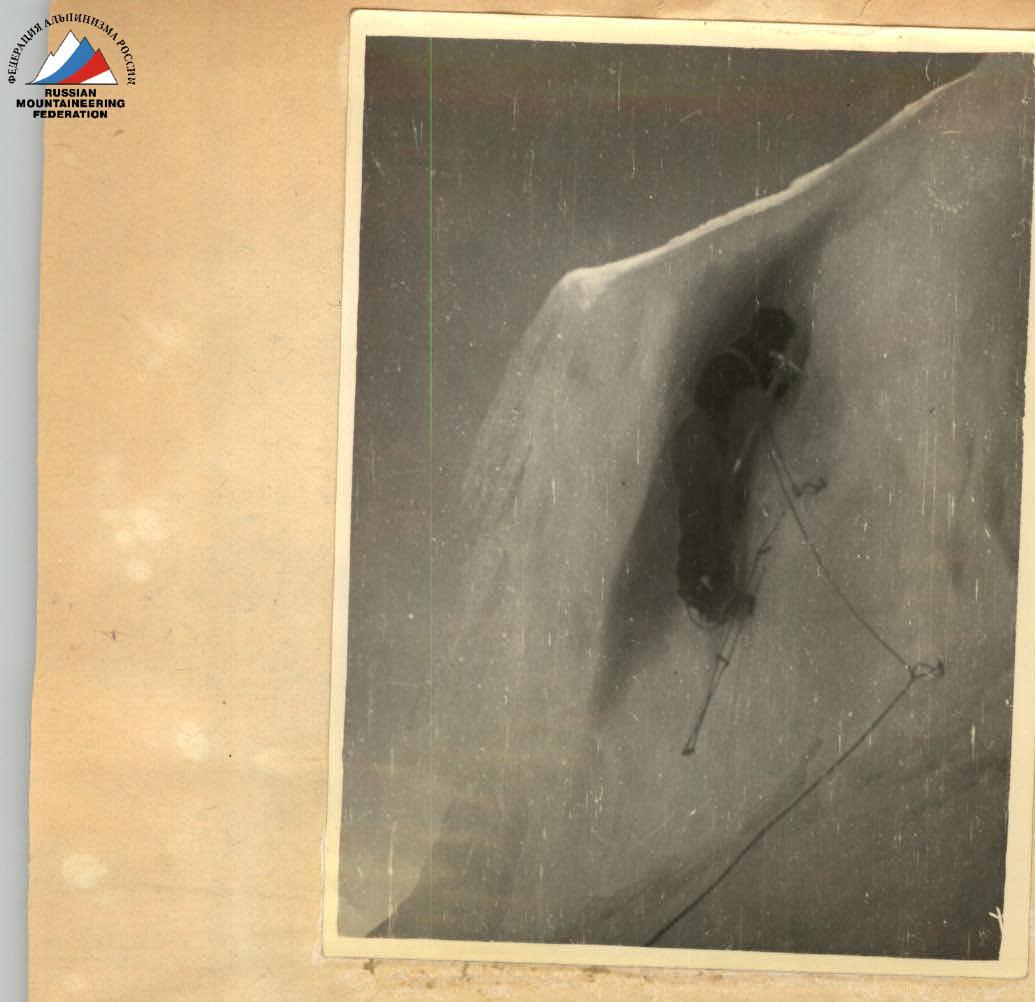
At 20:30 on July 22, 1957, a signal of well-being (one flash of light) was received from the assault group, and a response signal was sent. The location from which this signal was sent is marked on the photo (see №2).
July 23
The observer group tracked the assault group's departure from the overnight camp (2 on the photo) at 4:30 AM and their progress along the route (see photo).
At 20:30, a signal of well-being was received from the overnight camp location (3 on the photo), and a response signal was sent.
July 24
The observer group tracked the departure from the overnight camp at 4:00 AM and the progress along the route (see photo). They observed the overcoming of the 15-meter hanging ice cornice and the ascent onto the ice "cap" at 13:00.
There was no deception with signals in the evening, as the group had already crossed over the Donguz-Orun summit by then.
July 25
The group's movement was not tracked as they were behind the ridge.
July 26
The assault group was met by observers on the trail leading from the Donguz-Orun pass at 14:00.
Head of the observer group: Zhenier N.Ya., 1st sports category. Members of the auxiliary group: Agranovskaya, 3rd category; Yu. Shevelev, 3rd category; B. Litvinov, badge holder.
Description of the Ascent
July 21, 1957
At 10:00 AM, our group, consisting of M. Khergiiani and I. Kakhiiani, after prolonged and intense training, departed from the "Spartak" camp towards the Donguz-Orun peak, reaching the foot of its north face by 14:00, crowned by a grandiose ice cornice known as the "cap". We set up camp on the moraine, a 30-minute walk from the wall. Our observers, who would monitor our movement along the route, also camped here.
From the camp, we last observed the "life" of our wall and once again confirmed that it was very active. The constant rumble of rockfalls and ice avalanches was audible. We mentally retraced our chosen route, marking overnight locations. We were particularly concerned about the ice cornice capping the wall, which later proved to be the most challenging part of the route.
July 22, 1957 — First Day of the Route
Departure at 4:00 AM. We began the route at 4:30 AM, before the sun's rays could heat the upper part of the wall and trigger rockfalls. Initially, we moved across the glacier, the slope gradually steepening into a steep ice slope.
Weather Information During the Ascent of M.V. Khergiiani and I.G. Kakhiiani on Donguz-Orun via the North Face
Weather information pertains to the area visible to observers from the camp (see photo).
Day 1. July 22, 1957
Clear, sunny weather throughout the day. Weak wind. Temperature positive after sunrise.
At 19:00, the weather deteriorated — the Donguz-Orun massif was covered by thunderstorm clouds. Thunderstorm with sleet, followed by drizzle, continued until 3:00 AM on July 23.
Day 2. July 23, 1957
Variable cloudiness without precipitation in the morning, with visibility sometimes limited by fog. By evening, after exchanging signals at 20:30, — overcast with drizzle on the moraine below.
Day 3. July 24, 1957
Weather similar to the previous day.
Day 4. July 25, 1957
Variable cloudiness in the morning, with a downpour by evening.
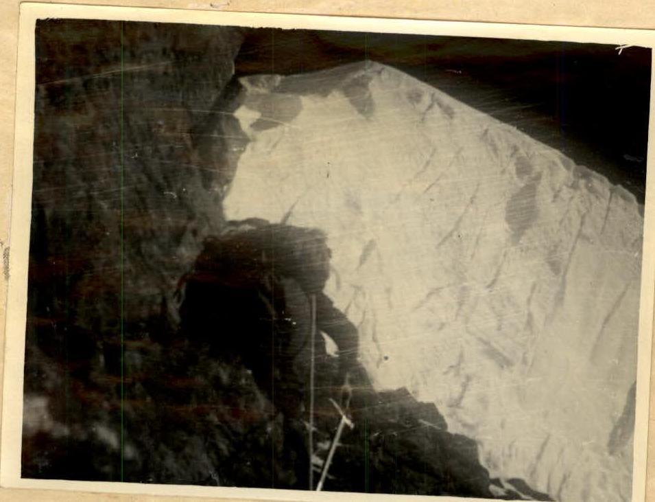
Head of the observer group (ZHENIER N.YA.). After crossing a significantly large subglacial crevasse via a bridge with careful belay, we approached the lower rocks of the first scalar triangle. We ascended directly up a narrow crevice. The rocks were initially of medium difficulty, with some challenging sections, but there were many ledges for belay and handholds, making passage not overly difficult. However, a 25-meter wall was encountered. We overcame this wall directly "head-on" with thorough piton belay and reached a narrow, inclined ledge covered in "live" rocks. We then ascended about 4 rope lengths up significantly destroyed rocks and approached a 30-meter wall, which was also overcome "head-on" due to heavily fractured ice slopes on either side. This wall completed the ascent of the first scalar triangle, where we established control cairn №1. The length of the traversed scalar section was about 250 meters.
After the first scalar section, the path proceeded across a significantly fractured ice slope, one of the most challenging and avalanche-prone sections of the route. Having traversed the slope with careful piton belay (the second in the "rope team" continuously monitored for rocks and avalanches from above), we approached a 5-meter ice wall, which we overcame using a ladder and initial pitons. Following the wall, a large bergschrund blocked our path. Unable to tackle it "head-on" due to its negative slope, we entered it and moved rightward along the ice blocks filling it for about 40–50 meters, where the wall, though still negative, was lower, about 4–5 meters. Using ladders, we exited onto a snow slope with a 65–70° gradient and approximately 120 meters in length. We ascended directly up this slope under the second scalar triangle. The time taken to overcome the path from cairn №1 to this location was 4.5–5 hours. The second scalar triangle consisted of sheer, monolithic rocks of significant difficulty, with internal corners, gullies, and almost no handholds, as the rocks were covered in superimposed ice. Rocks and ice fragments whizzed past from above. The average steepness of this section was 65–70°.
Transitioning from the snow slope to the lower rocks proved very challenging due to a large crevice between the rocks and ice. After moving along the rocks to the right for about 30 meters, we found a crevice to ascend, using piton belay. Further ascent was up steep slabs, very difficult due to the near absence of handholds and few cracks for piton placement, necessitating the use of wooden wedges.
The slabs ended at an inclined terrace, where we could briefly rest, though water continuously dripped from above. After a quick snack, we continued directly up wet, steep, and smooth rocks. Progress was complicated by the need to clear handholds of ice.
After 65–70 meters of upward movement, we reached:
- destroyed rocks;
- sections of difficult rocks;
- areas dissected by internal corners with stoppers, for which ladders were used.
This section's ascent led to the snowy ridge of the second scalar triangle, onto its shoulder. The ridge was narrow and sharp, constantly exposed to rockfall from above.
Given the late hour (around 17:00), it was decided to find a location for an overnight camp. We descended slightly below the ridge and took turns carving out a platform: one worked while the other monitored for rocks. This continued for about two hours, but we still couldn't settle due to ongoing rockfall.
We decided to retreat to a safe location and wait until the morning frost could stabilize the rocks. The wait was considerable. At 20:30, we sent a light signal to our observers and received a response.
Only around 9:00 AM could we climb into our tent and prepare dinner. At 22:00, the weather began to deteriorate sharply, with sleet reducing visibility to 10 meters, enveloping us in fog. Trying to bolster each other's spirits and hoping for better conditions in the morning, we settled in for the night. Sleep was poor due to concerns about the weather and rockfall. However, around 1:00 AM, the sleet ceased, and by 3:00 AM, the sky was clear of clouds.
July 23, 1957 — Second Day of the Route
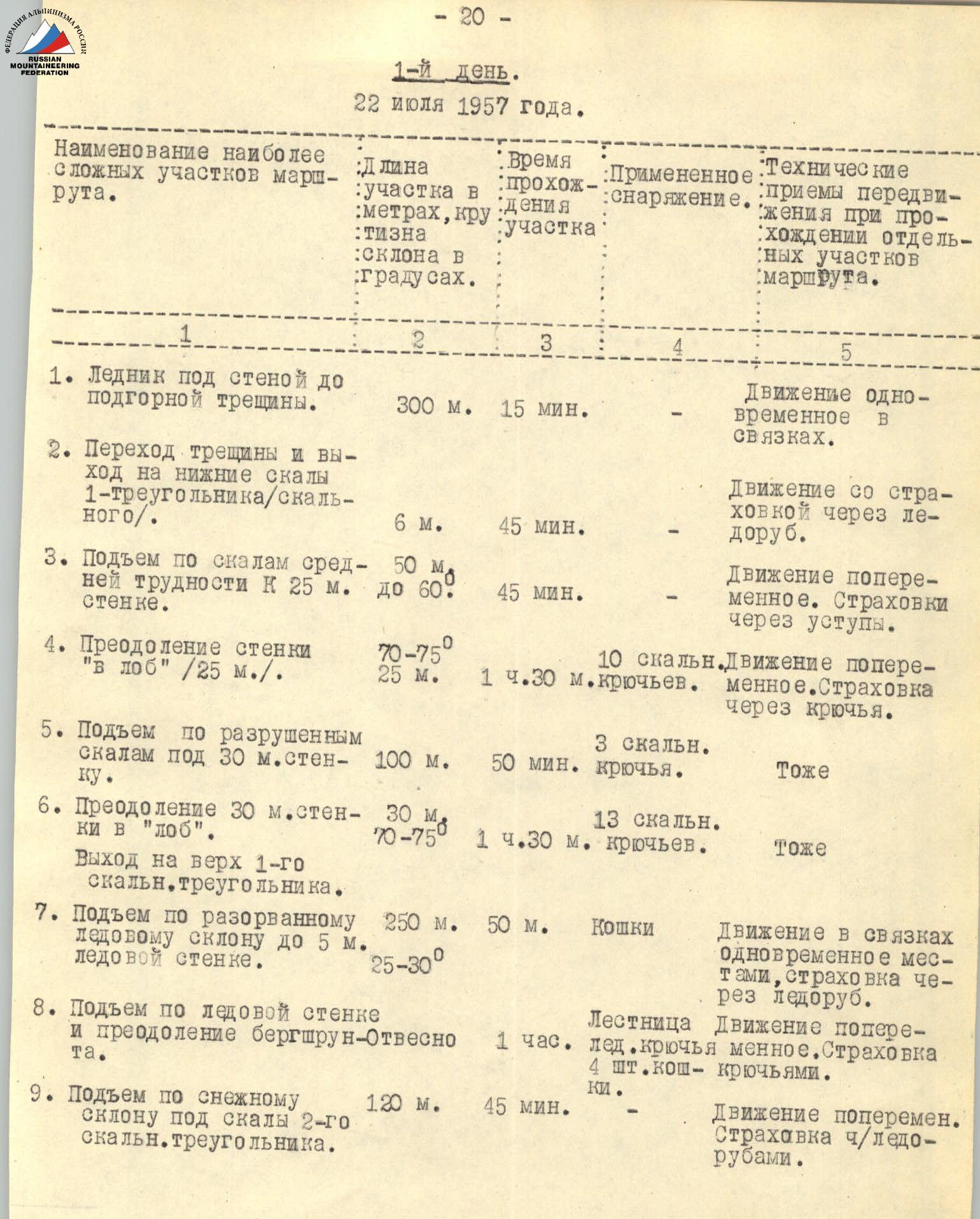
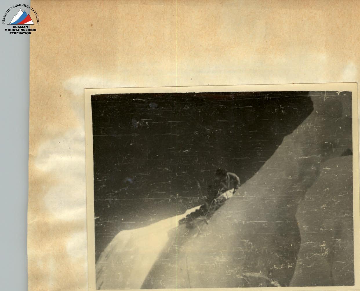
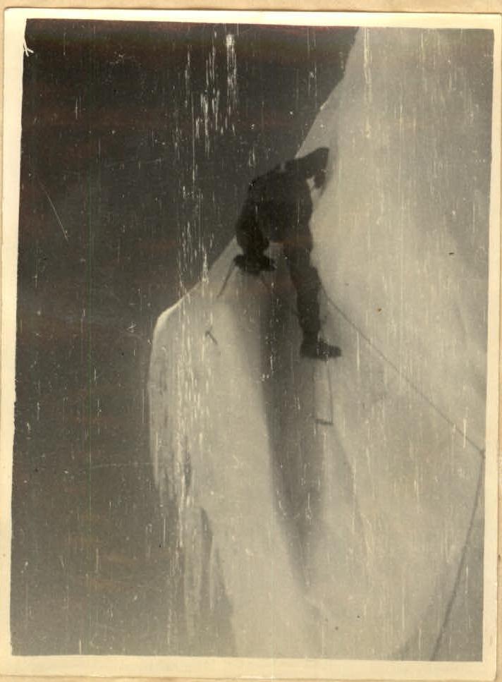
Departure at 4:00 AM, with a 4:30 AM start after a light breakfast, as we anticipated another rockfall. Initially, we moved along the ridge with belay via ice axe, covering about 80–90 meters. Following the snowy ridge, the path proceeded along a scalar, not clearly defined ridge, destroyed but with sections of monolithic rocks featuring internal corners with very few handholds and up to 75° steepness. Traversing this section required thorough belay via pitons and the use of ladders for internal corners, spanning over 100 meters. We then reached a steep ice slope (70–75° steepness) approximately 100 meters long, which we overcame directly upwards using crampons and step cutting, creating about 100 steps. This slope led to a destroyed scalar ridge with inclusions of superimposed ice. We moved cautiously with reliable belay via pitons. After 2 hours and 30 minutes of movement, we reached a snowy slope gradually transitioning into a steep ice slope about 300 meters long. We ascended directly up, cutting steps (about 150) and using piton belay. The passage was complicated by the constant threat of rocks and ice fragments. Following the ice slope, we reached a scalar section of medium difficulty with many handholds. Approaching these rocks, we considered resting, but couldn't find a suitable spot. After a short rest, we continued upwards.
Upon ascending 40 meters and traversing the rocks leftward, we crossed an ice gully with continuous rockfall. We then ascended along the edge of the gully, initially on an ice slope with step cutting, then on scalar outcrops heavily snowed and, after 150 meters of ascent with thorough piton belay, approached beneath the нависающую над нами, so-called "cap", representing a huge ice cornice ready to collapse at any moment.
It was around 19:30. Unable to find a suitable platform for an overnight camp, we bivouacked sitting, tied to loops. The night was very cold; our legs froze, but there was no alternative, with the constant rumble of ice avalanches nearby.
July 24, 1957 — Third Day of the Route
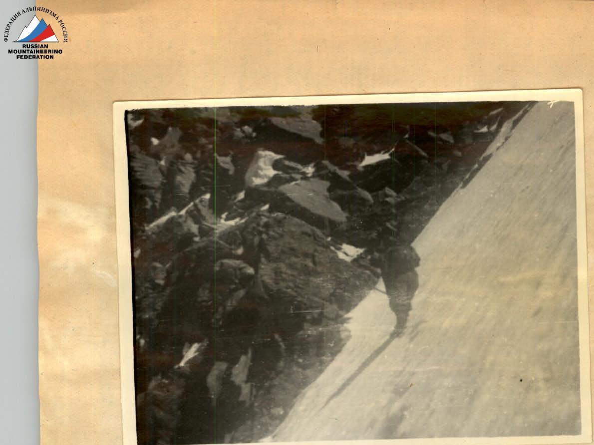
We began moving at 4:00 AM. Initially, we ascended directly up snow-covered slopes for about 40 meters, then along an ice slope for about 30 meters, directly transitioning into the "cap" — an ice wall with a 15-meter negative section.
This 15-meter negative wall initially stumped us, casting doubt on its feasibility. However, there was no alternative route, and descending was even more dangerous and complex.
After resting and assessing our options, we moved upwards. After 9 hours of strenuous work with ladders, pitons, and ice axes, and significant mental and physical strain, the wall was overcome. Following the wall, the path was an ice slope with a 75° gradient, which seemed gentle after the wall. We traversed it with piton belay, cutting steps. This slope gradually transitioned into a steep mixed slope, leading us to the top of the "cap". Workers from the Moscow Academy of Sciences, led by Honored Master of Sports N. Gusak, observed our ascent and greeted us with rifle salvos as we reached the top of the "cap", which reached us as faint bangs. This greatly boosted our morale. On the summit, we placed a festive record in a cairn and, congratulating each other on a significant victory, began our descent to the false Donguz-Orun pass, where we camped overnight. Here, we were warmly greeted by a group from the "Spartak" alpine camp.
The next day, July 25, 1957, we arrived at the "Spartak" camp, where we were given a ceremonial welcome by the entire collective.
Thus ended the victorious assault on the formidable and treacherous north face of Donguz-Orun.
On the First Ascent by the Group of USSR Merited Masters of Sports M. Khergiiani — I. Kakhiiani via the North Face of Donguz-Orun (4468 m)
Characterization of the Route and Its Execution
Based on years of striving to achieve the first ascent via this route, thorough study, and personal observations during the assault on July 22–24, 1957, I provide a characterization of the route and its execution.
The overall height of the North Face is about 1700–1800 meters with a steepness of around 60–75°. The northern exposure complicates the ascent due to late warming by the sun, though this doesn't diminish the danger from rockfall, avalanches, and falling ice blocks from the summit "cap", which practically doesn't cease throughout the day.
The wall is primarily composed of significantly destroyed, friable rocks covered in superimposed ice, making piton placement challenging in many critical areas.
In the lower part of the wall, climbers faced complex bergschrunds requiring high technique and modern equipment. The scalar "triangle" itself, made of exceptionally destroyed rocks, demanded work with pitons and piton protection.
The mid-section of the wall initially traversed across the glacier (lower part of the "seven") with ascent to a snow-ice slope under constant threat of avalanches and falling ice from above and right. Further, a complex scalar section followed, friable and threatening rockfall, necessitating piton use.
The first overnight camp on the wall was chosen out of necessity in the only feasible location, far from safe or comfortable. The group waited for late hours before setting up camp, hoping the night frost would stabilize the friable areas above.
The second day's route initially traversed scalar rocks, then transitioned to a sharp ice-snow ridge where, in some places, climbers had to move "astride" with belay via ice axe. Further movement leftward onto the main rocks of the wall involved steep sections of superimposed ice covered by a thin, unstable layer of snow, requiring the cutting of many steps and piton placement where possible. Scalar gullies and couloirs above the group constantly posed the risk of avalanche or rockfall, demanding careful route planning, cautious work, and a swift pace.
Advancement up the upper part of the wall required maximum climbing technique and a significant number of pitons.
Approaching the summit "cap" increased the risk of being hit by large ice fragments, necessitating precise orientation and a safe overnight location.
The upper overnight camp was established with great difficulty, below the zone of superimposed ice, without a tent, on pitons.
The final day of the assault began with a traverse leftward under the threat of the нависающей "cap", its ice wall being about 90 meters high. Here, after traversing leftward, the group ascended a classic ice section with a negative angle and about 14 meters in height, achieving this with immense tension and risk over a considerable time.
The ascent via self-belay and ladders on this section is worthy of the highest assessment for route difficulty and climbers' mastery. After complex, high-altitude, labor-intensive work on an 1800-meter wall, in excellent tempo, and after significant physical exertion over the previous two days and two frosty, sleepless nights, the group successfully applied their experience and climbing skill at the most challenging key location.
Above the "cap", with gradually easing relief, the group still faced a considerable path with an unstable snow layer on ice, further complicating the ascent to the summit.
The successful execution of this daring and technically difficult route, in a swift tempo, masterfully, with exemplary tactics, without failures or accidents, was significantly aided by the fact that the group consisted of only two climbers, maximizing mobility and safety.
I believe the difficulties encountered during the first record ascent in 1957 by M. Khergiiani and I. Kakhiiani, and their classification of the North Face of Donguz-Orun as category 5B, are entirely justified.
October 4, 1957. Terskol.
Honored Master of Sports of the USSR in mountaineering: N. Gusak.