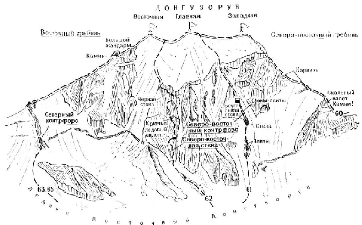
- Donguzorun Glavny via North-Eastern контрфорс (O. Vladimirov's route, category 4B). From the "Baksan" alpine camp (a group of 4 people) cross the Yusengi River by bridge and ascend via the trail on the left bank leading to the Becho Pass. At the Northern Shelter, return to the right bank of Yusengi and follow the grassy slopes and moraines along the river to reach the East Donguzorun Glacier. Continue ascending via the right-bank moraine of the glacier to the platforms opposite the North-Eastern контрфорс of the Glavny Donguzorun peak. Camp on the moraine platforms. From the "Baksan" alpine camp, 5–7 hours. From the camp, ascend via the moraine until its end. Here, exit left onto the surface moraines of the East Donguzorun Glacier and follow them to the rocky outcrops on the right edge of the triangular wall of the North-Eastern контрфорс of the Glavny Donguzorun peak. Ice falls are on the right. Ascend the snow-ice slope from the glacier to the bergschrund under the Second Rocky Outcrop; above the bergschrund, exit onto the smooth, steep slabs of the outcrop and ascend 100–150 m up the slabs ("live" rocks) to its summit. From the outcrop, ascend 80–100 m straight up the steep rocky-snowy slope to under the wall on the left side of the rightmost rocky cape of the North-Eastern контрфорс. Ice falls from the hanging glacier are on the right. Continue via rocks of above-average difficulty; a 25 m wall straight up (piton protection!). From the wall, a 140-meter ascent up steep, smooth, icy slabs (piton protection!). Then, 50 m up rocks of average difficulty with small ledges, and again 75–80 m up steep slabs alternating with small difficult walls to reach the ice slope. Ascend the 120-meter ice slope with rocky outcrops to under the sheer wall. Follow a crack in the wall 15 m straight up to a ledge. From the left end of the ledge, ascend 6 m, then traverse right via a horizontal crack to exit onto a ledge. From the ledge, ascend via an internal corner to a platform in a wide chimney. Camp on the platform. From the moraine, 10–12 hours. From the chimney, ascend straight up a 50-meter wall, then 20 m via ledges under an overhanging 3-meter wall. Overcome the wall directly (artificial aids!). Continue 100–120 m up steep, icy rocky slabs to under a 12-meter wall, which is also overcome directly. From the wall, ascend via an 8–10-meter ice-snow belt, a 25–30-meter rocky wall, and through a snow-ice cornice to exit onto the ice-snow контрфорс. Ascend the sharp 150-meter ice-snow, then 100–120-meter rocky-snowy контрфорс (cornices!) upwards. Overcome small gendarmes on the ridge directly. Camp on a wide ledge on the right side of the контрфорс. From the wall camp, 8–10 hours. From the camp, ascend 160 m up snow-covered rocks of average difficulty on the контрфорс to under a 30-meter wall. Under the wall, a 60–80-meter difficult traverse via icy slabs, sometimes alternating with small ice sections (piton protection, ice falls!) — to an internal ice corner. Ascend the corner (on crampons) 80–90 m upwards, then via a 20–25-meter ice crack, a 20-meter ice chimney, and a small snow-firn wall to reach the snow field of the Donguzorun massif. Ascend the snow fields (crevasses!) to reach the Main peak. The descent via the South-Western slope through the Western peak is described in route 55. The route duration is 4 days. Special equipment for 4 people: main rope — 2×40 m, auxiliary cordelette — 3 m, rock pitons — 16–18, ice screws — 6–8, rock hammers — 2, carabiners — 10–12, crampons — 4 pairs, tent — 1. Possible camping sites — on all platforms and on the summit. ("Baksan Valley", A.F. Naumov)
Warnings
- This text was translated automatically
- This text was processed automatically
Attached files
Sources
Comments
Sign in to leave a comment