ASCENT REPORT
-
Category: winter ascent.
-
Central Caucasus, Adyl-SU gorge.
-
Peak Volnaya Ispaniya via the North face (Kizel's route).
-
Difficulty category: 5B.
-
Height difference — 580 m, length — 850 m, out of which 5th and 6th difficulty categories — 110 m. Average steepness — 50°.
-
Pitons used:
Ice screws: 38 (0) Rock pitons: 5 (0)
Existing bolted pitons on the route (6 pieces) were used for belaying.
-
Team's total climbing time — 14 hours.
-
Overnight stay: on the summit.
-
Participants: Burlutsky Sergey Viktorovich — CMS.
Litvinenko Svetlana Nikolaevna — CMS.
-
Senior coach: Evseev Yuri Ivanovich.
Coach: Litvinenko Svetlana Nikolaevna.
-
Departure to the route: February 14, 1995.
Summit: February 14, 1995. Return: February 15, 1995.
-
Team from the Rostov Mountain Sports Committee.
PREPARATION FOR THE ASCENT
Preparation for the ascent started in September 1994, when the first information about the winter class of the 1995 Russian Championship appeared. The preparation was conducted in four stages.
-
Stage — choosing the region. Various options were considered, but the unstable general situation in the country led to the necessity of choosing a well-known and relatively safe region of the Central Caucasus. The anticipated expenses for the event were also taken into account.
-
Stage — selecting the objective. The North face of Peak Bashkara was chosen as the primary objective, and Peak Volnaya Ispaniya as the backup. In December 1994, a reconnaissance was conducted to assess the state of the route on Peak Bashkara. The results showed that a safe approach to Bashkara via the Bashkara glacier was quite problematic. An alternative approach via Yanman Pass and the Jantuganskoe Plateau was also considered.
-
Stage — preparation for departure. Significant attention was given to equipping the team and the rescue team with modern mountaineering gear. The following items were purchased:
- ropes,
- "Koflach" boots,
- crampons,
- ice screws,
- etc. The departure dates were scheduled to coincide with student holidays, allowing for the transportation of novices and junior athletes.
-
Stage — training camp at the "Shkhelda" alpine base. The camp started on January 29. A cycle of training sessions was conducted, and a training ascent was made to Peak Via-tau. On February 2, the team participated in the open Moscow ice climbing championship. Observations during the training ascent and consultations with groups at the "Jantugan" alpine base revealed that:
- the danger of avalanches when ascending to Yanman Pass was very high;
- the ascent required significant physical effort due to deep, loose snow.
Considering these circumstances, it was decided to proceed with the backup plan.
General physical and technical preparation of the team began in September 1994 and followed a traditional plan:
- 3 times a week — training in the gym;
- Sunday — outing to the rocks or cross-country running.
MOVEMENT SCHEDULE
TACTICAL ACTIONS OF THE TEAM
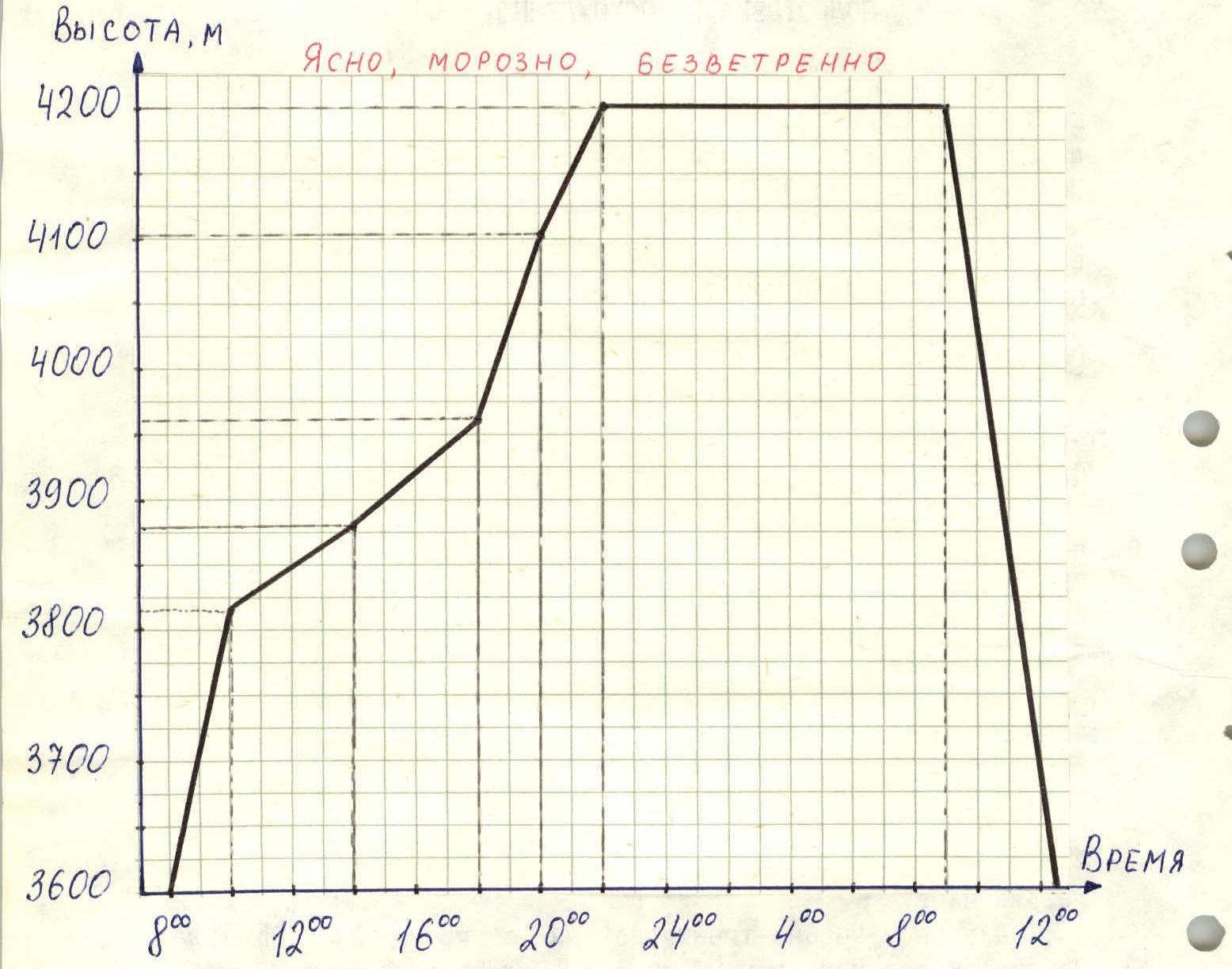
On February 14, 1995, at 8:00, the team departed from the initial bivouac. They put on crampons, harnesses, and tied in with a double rope immediately. The load was packed into one backpack.
On the R0–R1 section, they moved simultaneously, with Litvinenko leading and Burlutsky following with the backpack. After crossing the bergschrund, the movement became alternate with piton belays (using ice screws). From this point onwards until the summit:
- Burlutsky worked first.
- Litvinenko climbed with the backpack, using one rope as a handline and the other as a belay.
On sections R1–R2 and R2–R3, the ice was covered with deep, loose snow, requiring them to dig holes to screw in the ice screws. As the steepness increased (upon entering the crevice), the snow layer almost disappeared, but the ice structure was very loose and layered, unlike the "glassy" ice of Ullu-tau. To enhance belay reliability, they blocked the ice screws with a sling. For further progress, Burlutsky used two ice axes of the "Shakal" type, which seemed more reliable than ice axes, as they allowed:
- driving the pick into the ice to a significant depth.
At station R6 (ice screws), they made radio contact at 14:00 and had a light snack. While passing through section R7–R8 (considered 6th difficulty category):
- Burlutsky secured himself on pitons;
- Litvinenko took photographs from station R6.
Station R8 was set up on previously hammered-in bolted pitons. This station, like all others, was inconvenient; there were no footholds, requiring the use of short self-belaying.
Throughout the wall, they didn't encounter a single platform suitable for a bivouac.
Further on, the wall's steepness decreased, and the gullies and chutes contained firm snow, making progress easier. For belaying, they used:
- ice screws when encountering ice sections;
- rock outcrops on the left for additional support.
Around 17:00, they heard a loud avalanche rumbling in the direction of their intended descent route via the "trough". This confirmed the correctness of their decision to descend via the "trough" in the morning hours.
On section R10–R11, they made radio contact at 18:00. Litvinenko made the call as Burlutsky was working ahead. The base suggested an additional radio check at 20:00.
By 18:00, it started getting dark. Around 19:00, the full moon appeared, illuminating the slopes well. By 20:00, they ascended to the shoulder, where they made radio contact. The base suggested another additional radio check at 22:00. By 22:00, Burlutsky stood on the summit, and Litvinenko was approaching along the ridge. Litvinenko made the radio call.
On the summit, they organized a bivouac, prepared tea, and hot food. In the morning at 9:00, they began their descent and were on the plateau by 12:30.
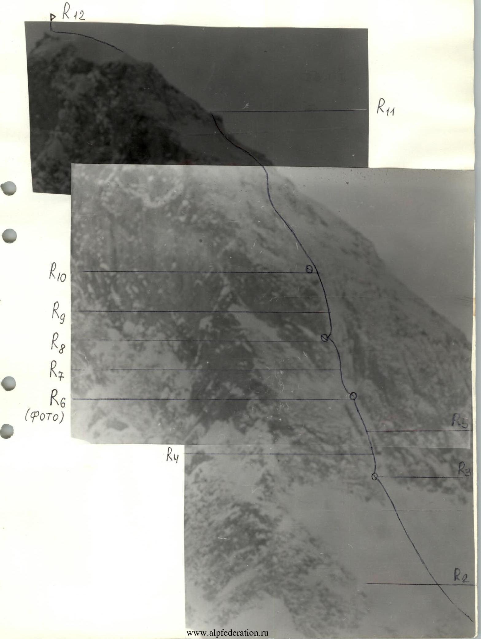
ROUTE DESCRIPTION BY SECTIONS
R0–R1 — a gentle ice-snow slope, simultaneous movement. R1–R2 — a gentle ice-snow slope located above drop-offs, belaying. R2–R3 — an ice-snow slope of medium steepness, belaying through ice screws. R3–R4 — entrance to a wide, steep ice gully. For passage — 2 ice axes; for belaying — ice screws. R4–R5 — a vertical ice-filled chimney. For belaying — ice screws and rock pitons. Exit from the chimney to the right. R5–R6 — a steep ice wall ending in an ice-snow cornice. Belaying — ice screws. R6–R7 — from under the cornice, left into a narrowing steep ice gully. For belaying — ice screws. R7–R8 — the gully transitions into a very difficult, overhanging narrow crevice. Climbing is very challenging:
-
through the crevice,
-
or along the rocks on the left side.
Belaying — rock pitons. At the exit from the crevice, bolted pitons are hammered in for station setup. Exit from the crevice — to the left. R8–R9 — a steep ice chute. For belaying — ice screws. R9–R10 — a steep ice gully. Belaying — through ice screws. R10–R11 — ice-snow gullies of medium steepness, with individual rocks and rock outcrops. A counterfort runs on the left. Direction of movement — up and to the right onto the shoulder. Belaying — through ice screws and rock outcrops. R11–R12 — movement to the left onto the snow dome of the summit. Along the snow ridge (cornices!), exit to the summit. There is a platform for an overnight stay on the summit.
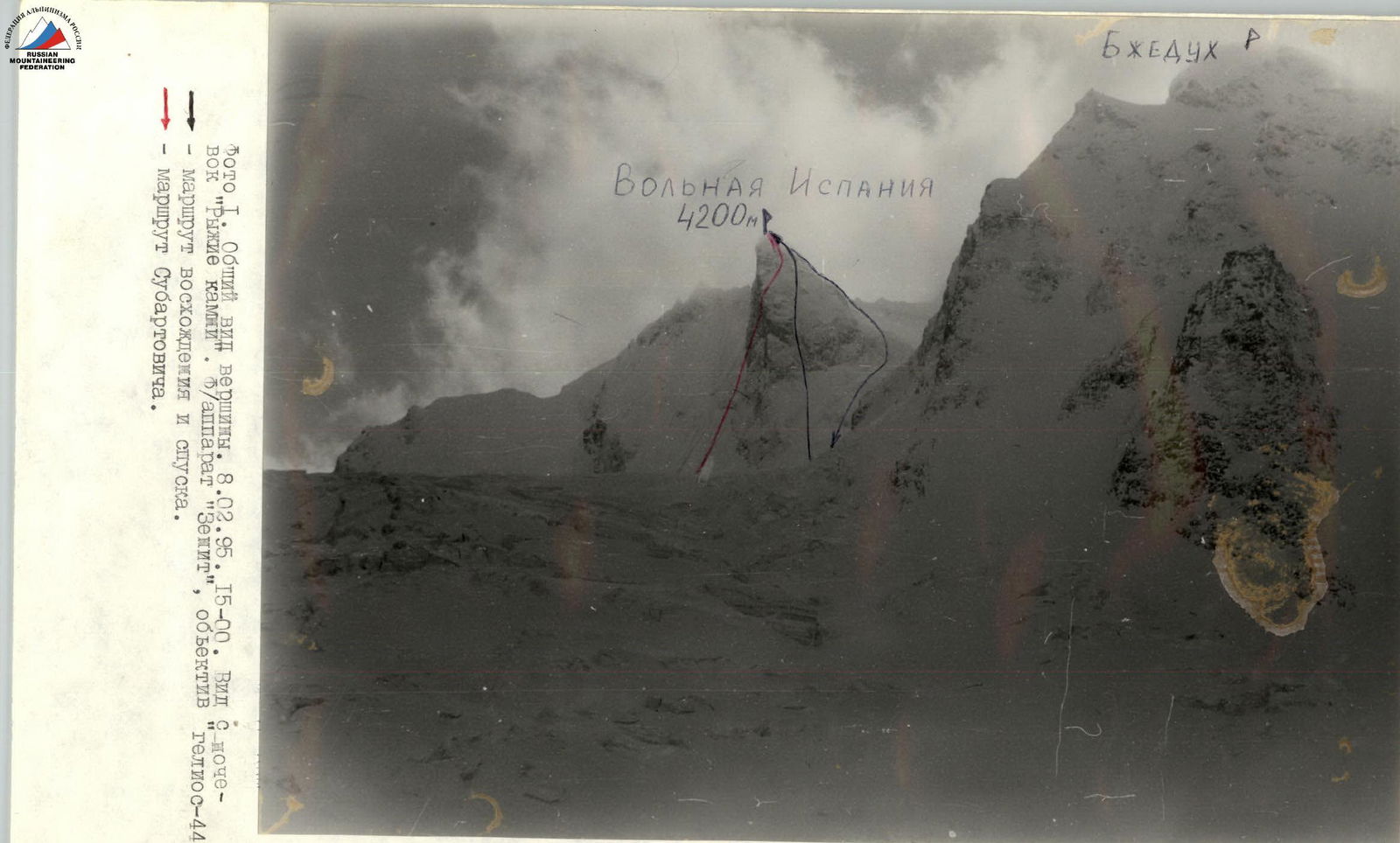
TECHNICAL PHOTOGRAPHY
February 9, 1995, 11:00. "Zenit" camera, telephoto lens.