ASCENT LOG
- Ascent classification: technical.
- Ascent area: Central Caucasus, Adyl-Su gorge.
- Peak, elevation: Pik Volnaya Ispaniya, 4200 m.
- Estimated difficulty category: 5A.
- Technical characteristics of the route:
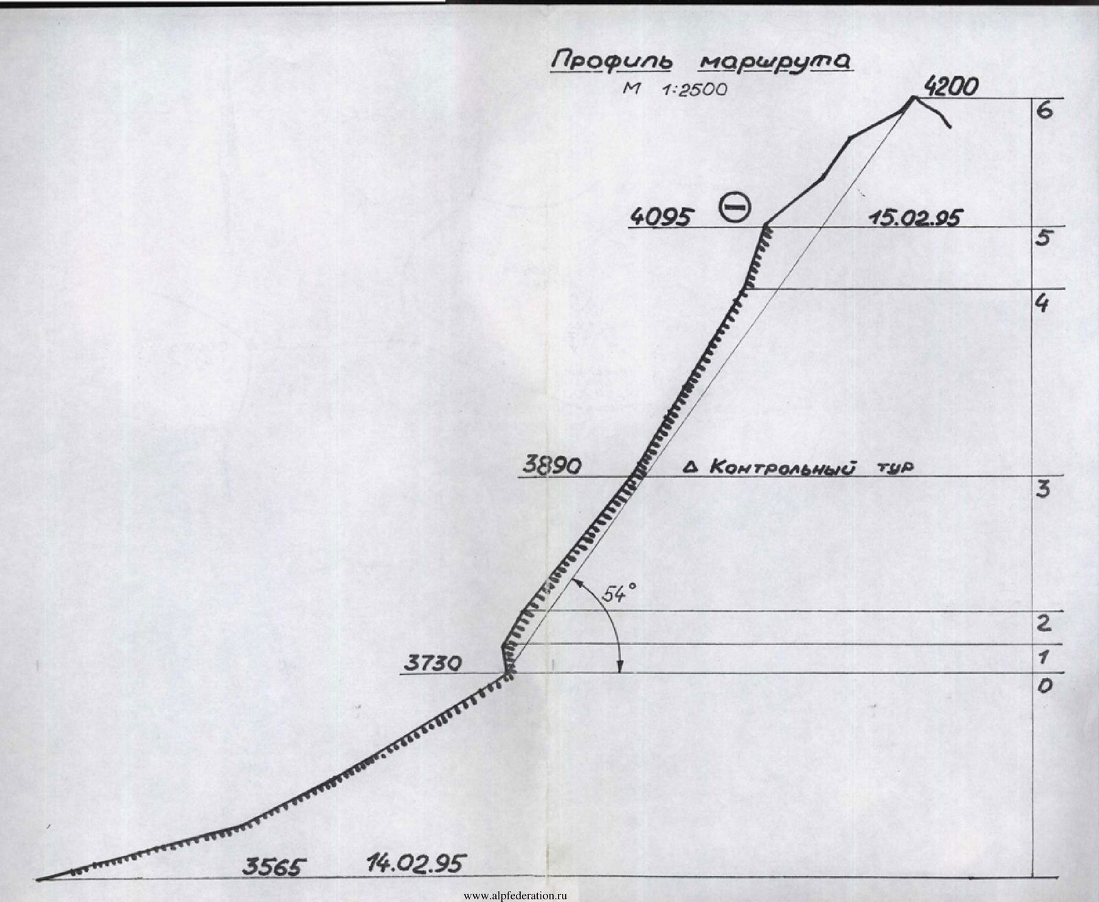
- elevation gain — 570 m;
- average steepness — 54°;
- wall section length — 550 m;
- avg. steepness of wall section — 65°.
- Pitons driven:
- rock — 4;
- chockstones — 5;
- bolt hangers — none;
- ice screws — 43.
- Number of overnight stays — one bivouac.
- Total climbing time: 19 hours.
- Team composition:
- Osipov Alexey Iosifovich — leader, 1st sports category
- Savchenko Alexander Evgenievich — participant, 1st sports category
- Tretyakov Sergey Igorevich — participant, 2nd sports category
- Shterenlicht Anton Lvovich — participant, 2nd sports category
- Departure date — February 14, 1995 summit — February 15 return — February 15, 1995
- Organization — SK MGTU named after N.E. Bauman.
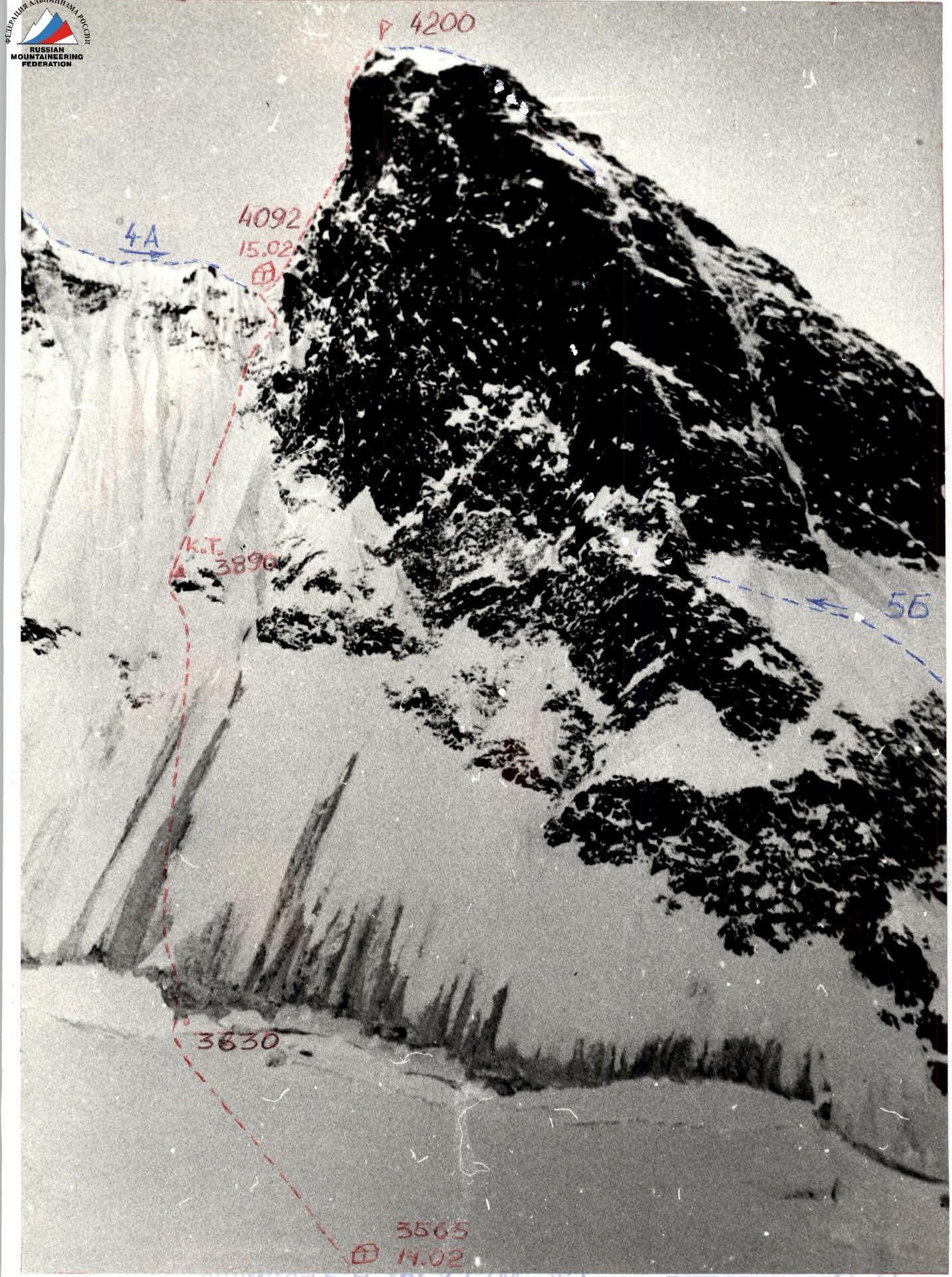
Pik Volnaya Ispaniya 4200 via S slope of E ridge 5A category approximately. Taken on February 13, 1995 at 15:00. Lens "T-22", focal length 75 mm. Approximate distance 1000 m, elevation — 3550, point # 1 on the diagram.
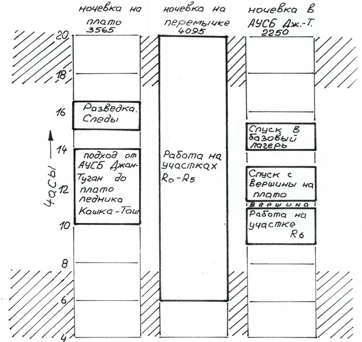
Ascent Schedule
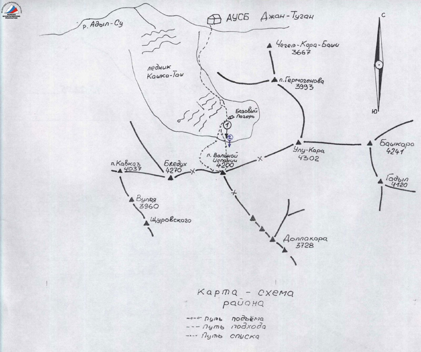
Map — diagram of the area
- ascent route
- approach route
- descent route
Route profile
Team's Tactical Actions
At 10:30 on February 13, the group approached the summit. By 15:00, they reached the plateau and set up a camp.
It was decided that it would be advisable to tread tracks to exit under the route in the dark the next morning. Therefore, the Savchenko–Shterenlicht rope worked from 15:00 to 16:30 on:
- marking the trail,
- reconnaissance,
- photographing the route.
They rose at 4:30 AM, had breakfast, and packed backpacks with the following distribution:
- 3 loaded packs
- 1 light pack with a sleeping bag and additional gear for the lead climber.
They left the base camp at 6:00 and were under the bergschrund by 7:00. They roped up about 50–70 m before the bergschrund due to possible crevasses.
Osipov A.I. started working first (He also led the rest of the day on February 14, on sections R1–R5). One of the key points on the route was the bergschrund; the first climber had to use two ice axes with stirrups.
On the first rope, four intermediate ice screws were placed. There was no pure ice when crossing the bergschrund; they had to clear a trench in the snow. (Photo # 1) Then, five ropes followed on firm, good ice (45–50°) with one intermediate ice screw per rope. A control cairn was built in a rock island crevice on a piton. From the control cairn, five ropes followed on ice with increasing steepness (50–60°) until a transition to the right into a couloir.
Progress slowed significantly due to the need to:
- dig a trench in the snow (to access the ice and ensure reliable protection — Photo # 4)
- dig a tunnel to bypass a cornice on the left.
This took approximately 2 hours 30 minutes and slightly adjusted the tactical plan. It was decided to bivouac on a ledge under the summit tower on a snow saddle. The bivouac site was very convenient; if needed, two tents could be set up. By 20:00 (designated communication time), the group set up a tent and had dinner.
On the ice wall, Osipov worked first, belayed by Tretyakov. Then, Tretyakov climbed up on fixed ropes and belayed Osipov; Savchenko climbed on fixed ropes and took in Shterenlicht on top-rope. On sections R1 and R5, all three climbed on fixed ropes. Belay points on sections R1–R5 were on two ice screws; at the end of R5, when exiting onto the saddle — a loop passed between rocks.
On February 15, they rose at 7:30, had breakfast, dismantled the bivouac, and began working on the rock section of the summit tower's ridge at 9:00 (this part of the route coincides with the route on the E ridge, category 4A by Abalakov). They climbed in two ropes: Shterenlicht–Tretyakov and Osipov–Savchenko simultaneously, leaving intermediate anchors (the first rope — second). By 11:00, they reached the summit.
Climbing time: February 14 — 13 hours, February 15 — 2 hours.
Hot meals:
- morning
- evening
Daytime — individual snacks.
Despite harsh winter conditions and a short daylight period, the tactical plan was largely executed with minor deviations. There were no injuries or incidents on the route; communication with the rescue team "Djan-Tugan" and the rescue squad of KSP "Shkhelda" was carried out regularly according to the schedule.
| Pitons | UIAA M 1:2000 | Cat. diff. | Length m | Steepness (deg) | R | |||
|---|---|---|---|---|---|---|---|---|
| rock | ice | bolt | chock | |||||
| 3 | - | - | 5 | 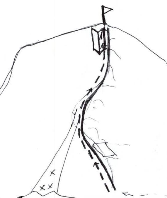 | -III | 150 | 30–45° | 5 |
| 1 | 4 | - | - |  | V+ | 50 | 70° | 4 |
 | 3 | |||||||
| - | 16 | - | - |  | IV+ | 220 | 50–60° |
Route Diagram in UIAA Symbols
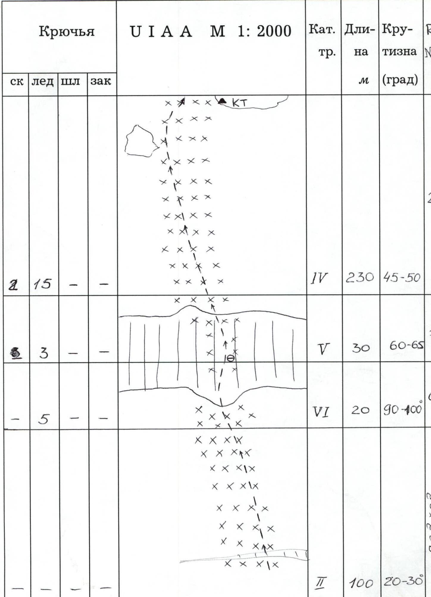
| Pitons | UIAA M 1:2000 | Cat. diff. | Length m | Steepness (deg) | R# | |||
|---|---|---|---|---|---|---|---|---|
| rock | ice | bolt | chock | |||||
| 2 | 15 | - | - | IV | 230 | 45–50° | 2 | |
| - | 3 | - | - | V | 30 | 60–65° | 1 | |
| - | 5 | - | - | VI | 20 | 90–100° | 0 | |
| - | - | - | - | II | 100 | 20–30° |
Route Description by Sections
February 13. Started moving at 15:00, finished — at 20:00. Reconnaissance of the route, tracks trodden to the route. Overnight stay on snow, bivouac.
February 14. Started moving at 6:00, finished — 19:00.
Along the glacier towards the bergschrund under Pik Volnaya Ispaniya 200–300 m on snow with a slope of 20–30° to approach the bergschrund near the tongue of pure ice. R0–R1.
Climb up the tongue of pure ice along the bergschrund wall, veering slightly left. R1–R2.
Up and left on firm, steep ice. R2–R3.
Continue moving up and left towards the "Gogol" rock pinnacle, mainly on ice, crossing snow bands. Pass between two rock islands. With a lot of snow on the ice, protection can be organized on the rock islands. On the upper right one — a Control Cairn. R3–R4.
Leaving the rock island to the right, move up and right, choosing ice sections, towards the ice couloir. R4–R5.
Enter the couloir and follow it, keeping to the left side, to exit left of a cornice (deep snow possible). Bypass the cornice on the left and ascend to the ridge. Here, on the saddle, is a good bivouac site.
February 15, 1995. Started moving at 9:00, finished — 14:00. R5–R6. From the saddle, from the bivouac site, ascend to the summit on easy rocks.
Descent. From the summit, descend towards the upper part of the "trough" — 3–4 rappels. Then down the "trough" onto the glacier plateau, Kashka-Tash.
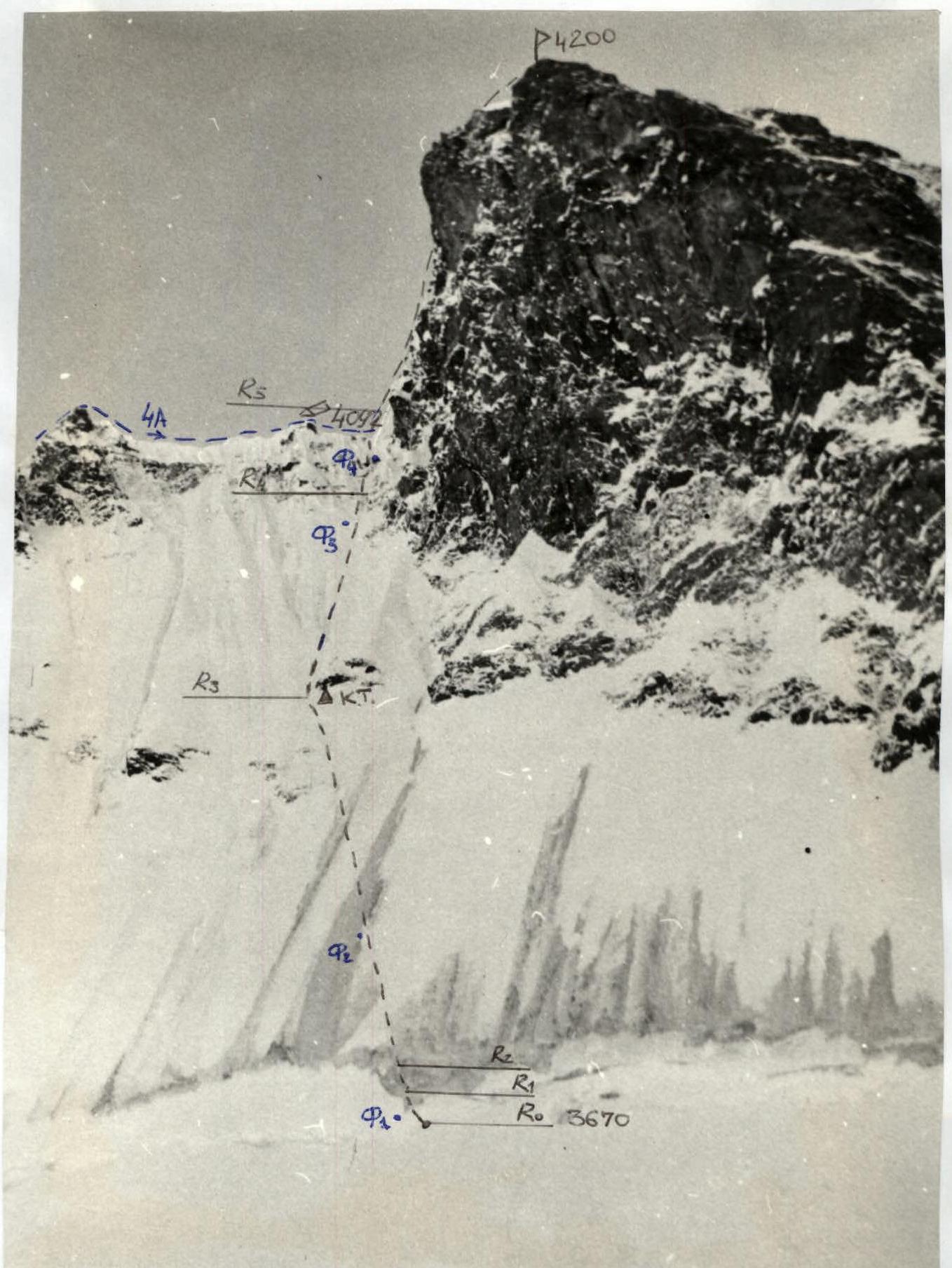
Pik Volnaya Ispaniya 4200 via S slope of E ridge 5A category approximately. Taken on February 13, 1995 at 16:00. Lens "T-22", focal length 75 mm. Approximate distance 400 m, elevation — 3650, point # 2 on the diagram. Photo # 1. Crossing the bergschrund. Section R0–R1.
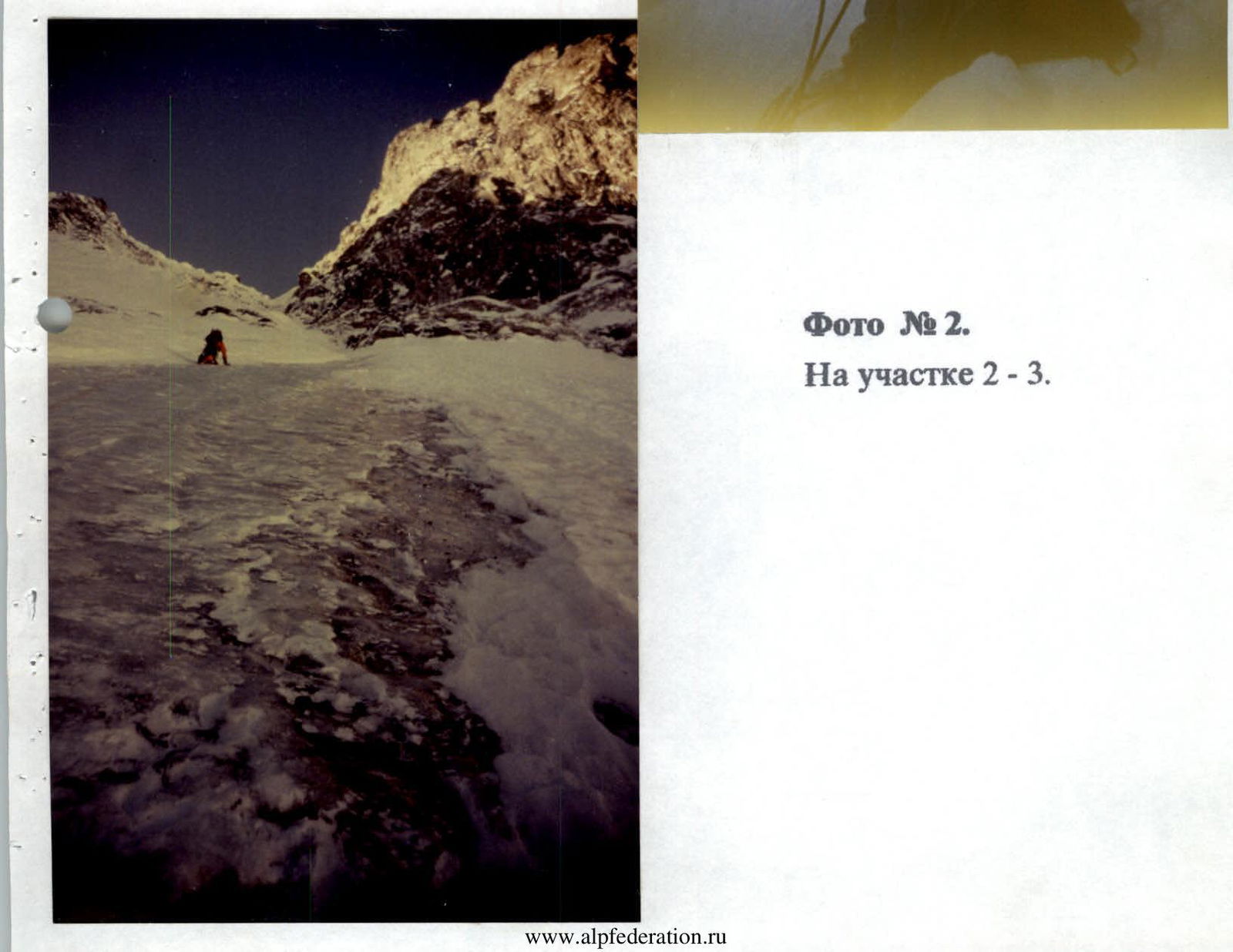
Photo # 2. On section R2–R3.
Photo # 3. Entering the couloir. Section R3–R4.
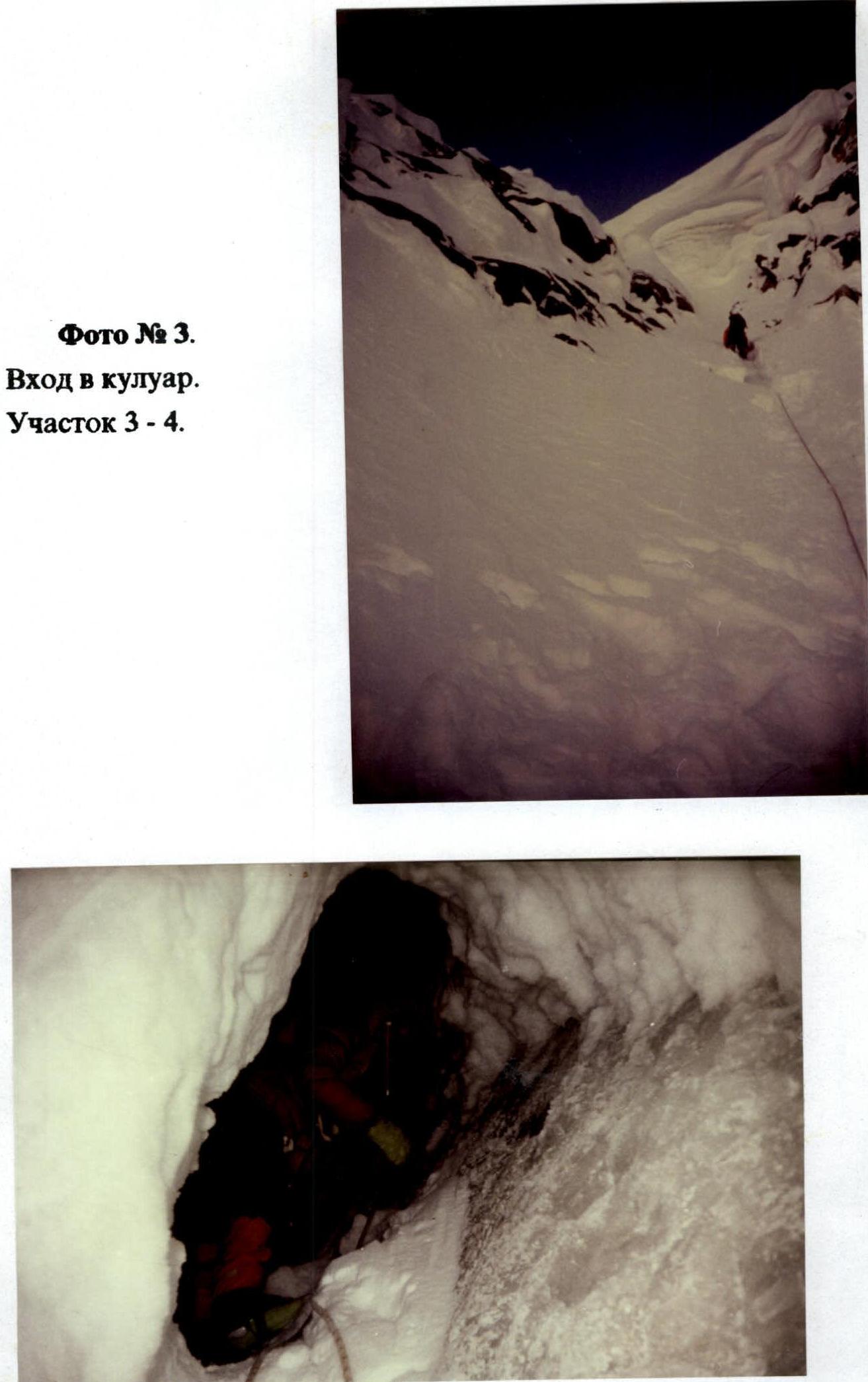
Photo # 4. Trench under the snow cornice on section R4–R5.
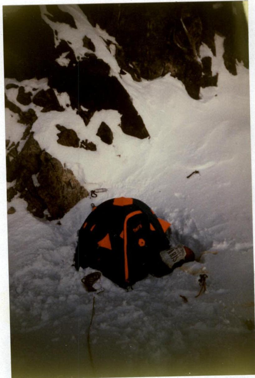
Photo # 5. Bivouac site on the saddle.
Photos taken with "Olympus AF S-2" camera, "Olympus" lens, focal length 34 mm, on "Kodak 100" film.