Report
On the first ascent of VIAtaou peak via the Northern slope of the Western ridge and the Western ridge, category 2A complexity (combined route) (tentative)
June 17, 2008
Report content:
- Ascent passport sheet 1 p. 1
- General photo of the peak sheet 1 p. 2
- Explanatory text sheet 2 p. 3
- Area map sheet 2 p. 4
- Route profile sheet 3 p. 5
- GPS data decoding sheet 3 p. 6
- UIAA route diagram sheet 4 p. 7
- Technical photo of the route sheet 4 p. 8
- Note from the summit sheet 5 p. 9
- Group photo at the summit sheet 5 p. 10
- Photo illustrations for the report sheet 6 p. 11–sheet 9 p. 18
The ascent was made by members of the Kursk Regional Youth Public Organization "SPORADIK". Kursk, 305004, 50 let Oktyabrya st., 94.
The report was compiled by V.F. Shvyransky. Kursk, 305029, K. Marksa st., 66/15–19.
tel.: (4712) 53-74-05, home: 8-903-639-01-49, mob.: E-mail: libra59@rambler.ru
Ascent Passport
-
Ascent area — Caucasus, Adylsu gorge, section number according to the 2001 classification table — 2.4 (from Chiper-Azau pass to Gumachi peak).
-
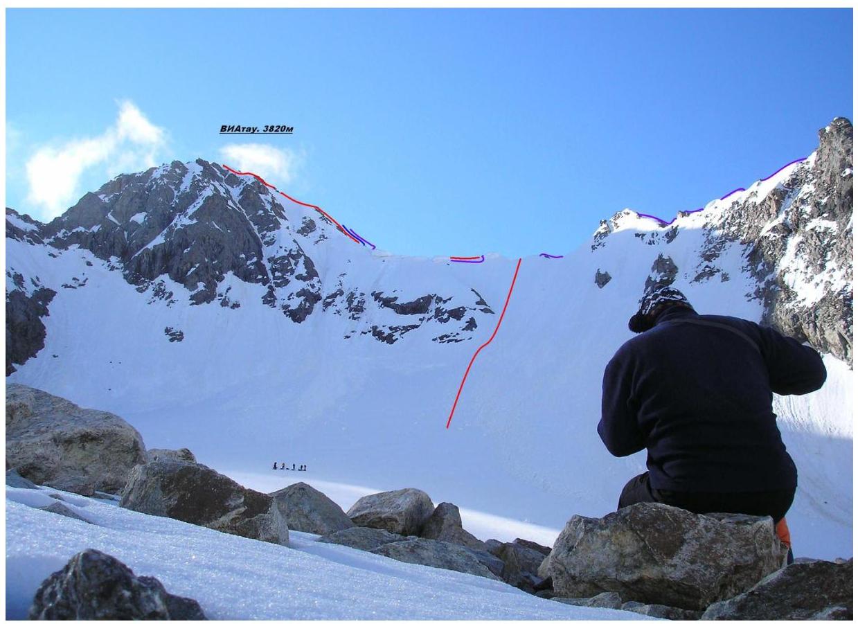
Peak name — VIAtaou, 3820 m a.s.l. (3764 m a.s.l. according to measurements on the day of ascent) via the Northern slope of the Western ridge and the Western ridge.
-
Proposed category — 2A, first ascent.
-
Route type: combined.
-
Route elevation gain: 332 m (according to GPS navigator). Route length: 567 m. Section lengths:
- category V — 0 m.
- category VI — 0 m. Average steepness:
- main part of the route — 47°
- entire route — 39°
-
Pitons left on the route: total — 0; including bolted pitons — 0. Pitons used on the route:
- stationary bolted pitons — 0; including for artificial support — 0;
- removable bolted pitons — 0; including for artificial support — 0;
- total artificial support points used — 0.
-
Team's climbing time: 8 h 30 min.
-
Leaders: Shvyransky Vladimir Felixovich, 1st sports category, 2nd category instructor-methodologist (cert. 1288); Duntsov Valentin Sergeevich, Candidate Master of Sports, 2nd category instructor-methodologist (cert. 867).
Participants:
- Proskurin Sergei Gennadievich;
- Matyukhin Alexander Vyacheslavovich;
- Lutsenko Anton Andreevich;
- Tretyakova Evgeniya Vladimirovna;
- Globin Maxim Grigorievich;
- Stakheiko Galina Savelievna;
- Vorontsov Danil Yurievich.
-
Coach: Shvyransky Vladimir Felixovich.
-
Departure for the route: 4:30, June 17, 2008. Summit arrival: 13:00, June 17, 2008. Return to base camp: 17:20, June 17, 2008.
The ascent to VIAtaou peak was conducted by the Kursk Regional Youth Sports Public Organization "SPORADIK" as part of the third stage of the mountain radio expedition of the International Student Forum. The event was organized by Kursk State Technical University and the Kursk Regional Committee for Youth Affairs.
The ascent area according to the Classification of Routes on Mountain Peaks — 2.4 Caucasus: from Chiper-Azau pass to Gumachi peak (Baksan, Adylsu, Shkhelda, Kyrtyk gorges).
The ascent was prepared and carried out under the guidance of 2nd category alpine instructors-methodologists: Shvyransky V.F., cert. 1288 (Kursk) and Duntsov V.S., cert. 867 (Prokhladny, Kabardino-Balkaria).
The event was registered on June 11, 2008, at the Shkhelda Rescue Station of the Elbrus Pyrrhias Rescue Service of the Russian Emergency Situations Ministry, which has the status of a year-round Alpine Camp.
The ascent to VIAtaou peak via the Northern slope of the Western ridge and the Western ridge (combined route) was made on June 17, 2008. Initial bivouac — "Green Hotel" (Adylsu gorge, foot of the Djankuat glacier).
The ascent was made via a new route not included in the Classification of Routes on Mountain Peaks. Currently, the Classification includes routes:
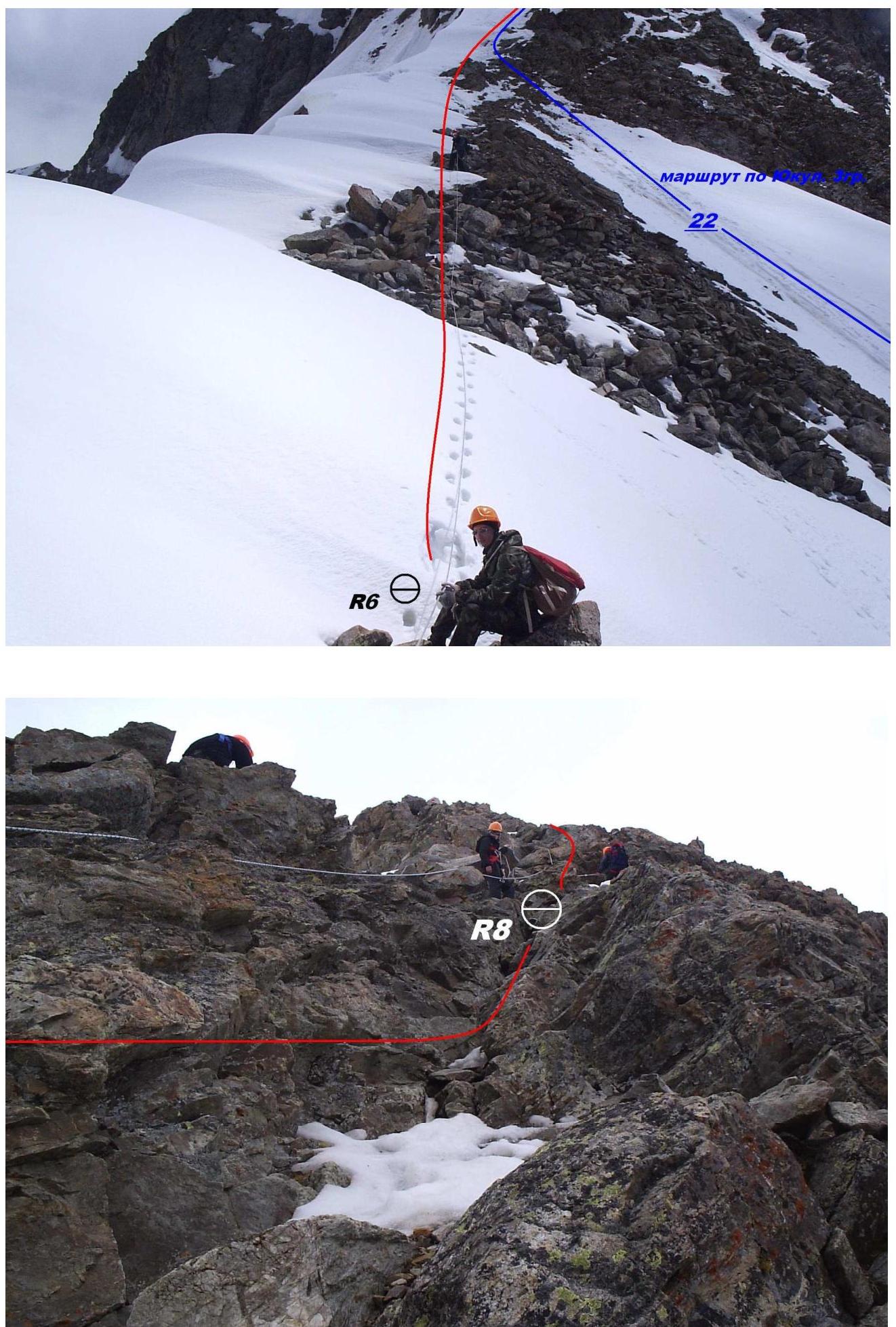
- No.22 — 1B (rock climbing) via the Southern couloir of the 3rd ridge, A. Karpov, 1936.
- No.23 — 2A (rock climbing) via the Northern ridge, Yu. Aristov, 1935.
- No.24 — 2A (rock climbing) via the Southern counterfort of the 3rd ridge, G. Lavrik, 1961.
- No.25 — 2B (combined) via the Southern ridge, S. Kozlov, 1946.
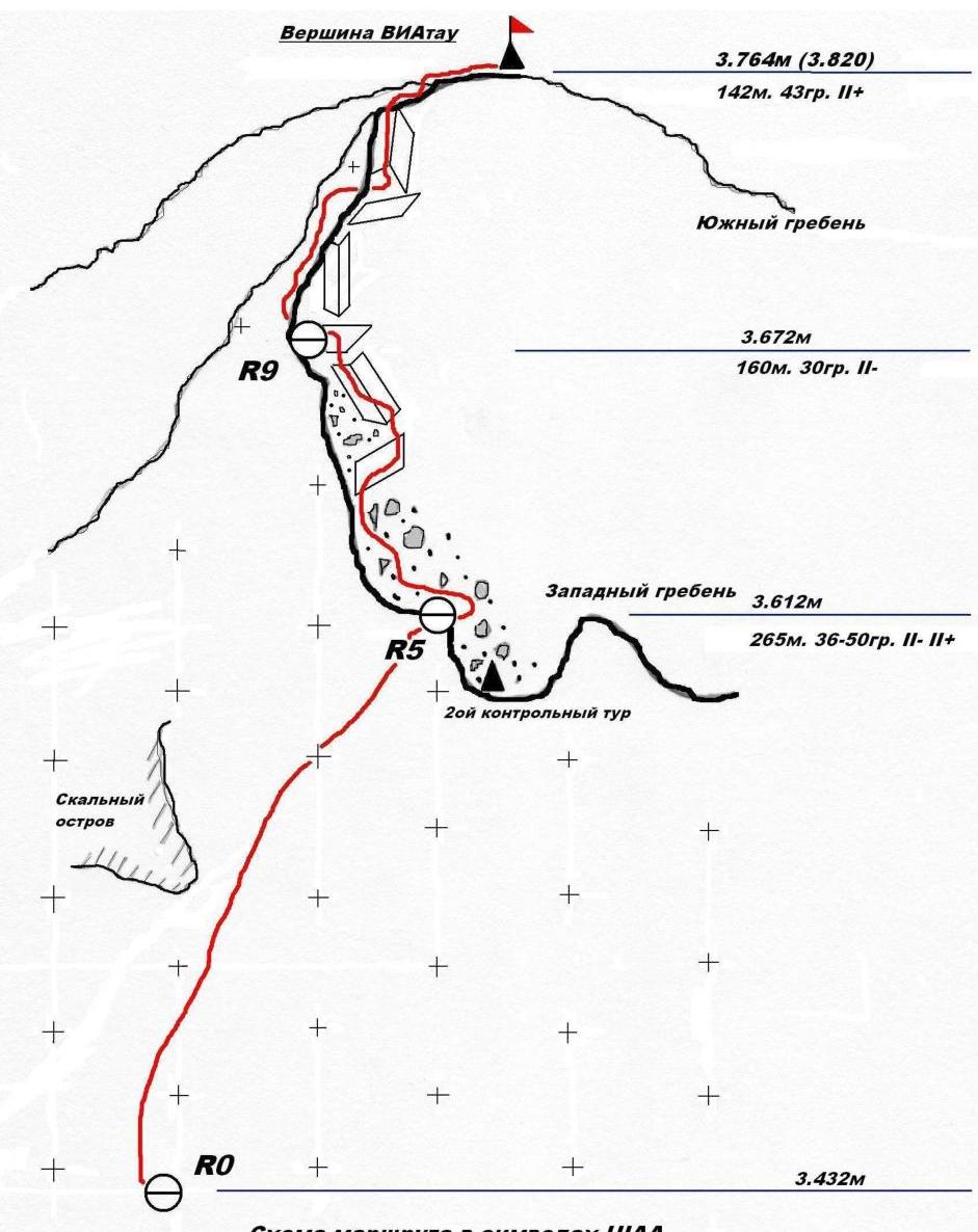
The group's route was marked with control cairns:
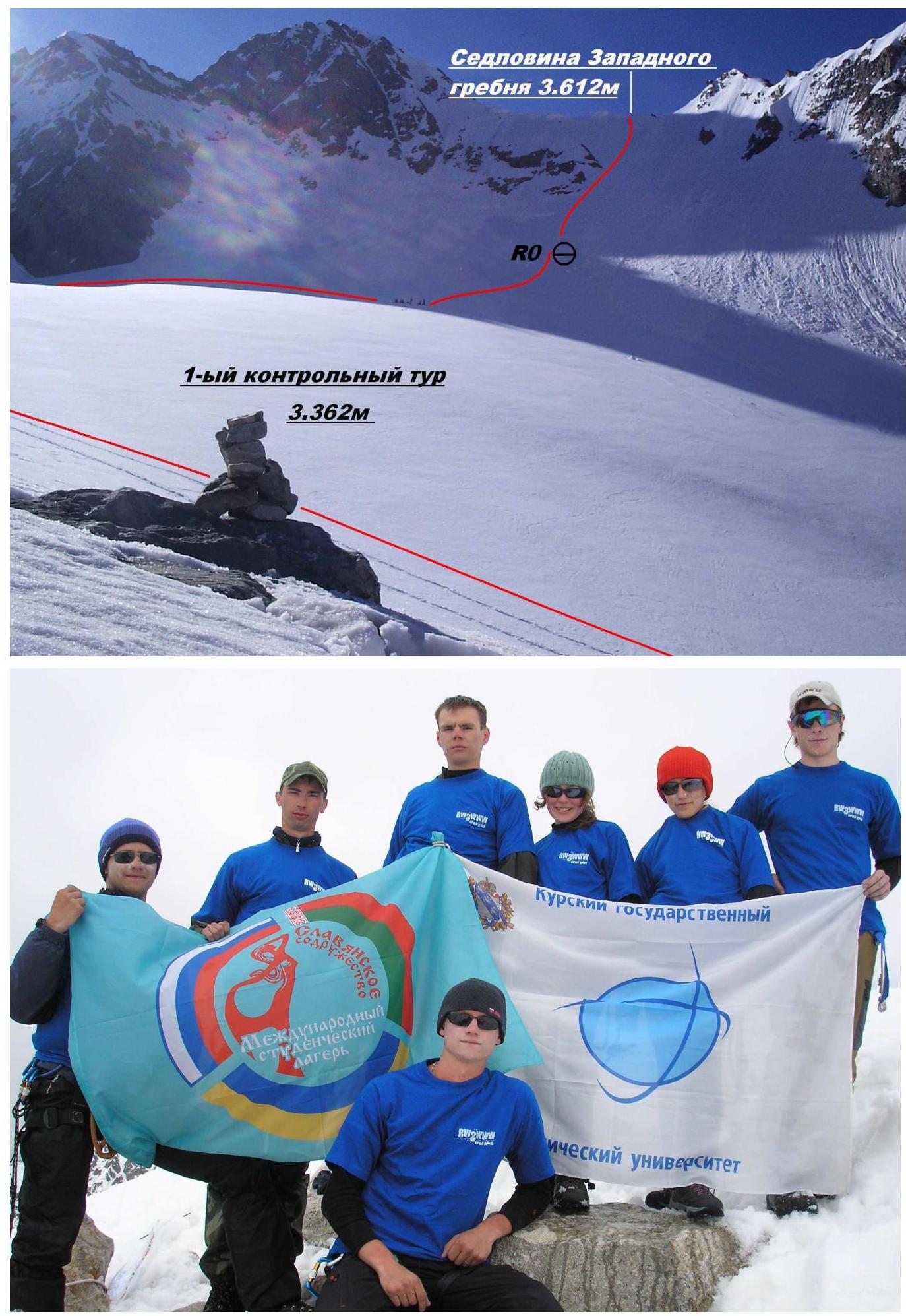
- 1st control cairn — on the moraine under the N. slope of the 3rd ridge (point TUR1 43°12,843′–42°45,709′; 3362 m a.s.l.),
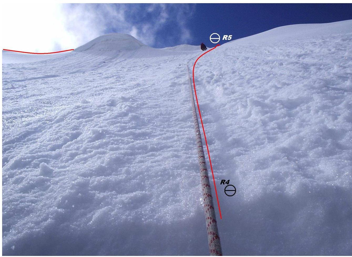
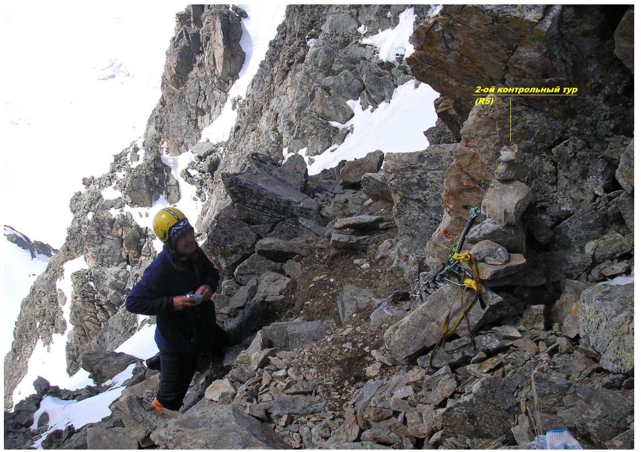
- 2nd control cairn — on the saddle of the 3rd ridge (point TUR2 43°12,634′–42°45,949′; 3612 m a.s.l.) and a summit cairn (point VIA 43°12,646′–42°46,125′; 3764 m a.s.l.). All coordinate and altitude measurements were made using a "Garmin Etrex Camo" GPS navigator.

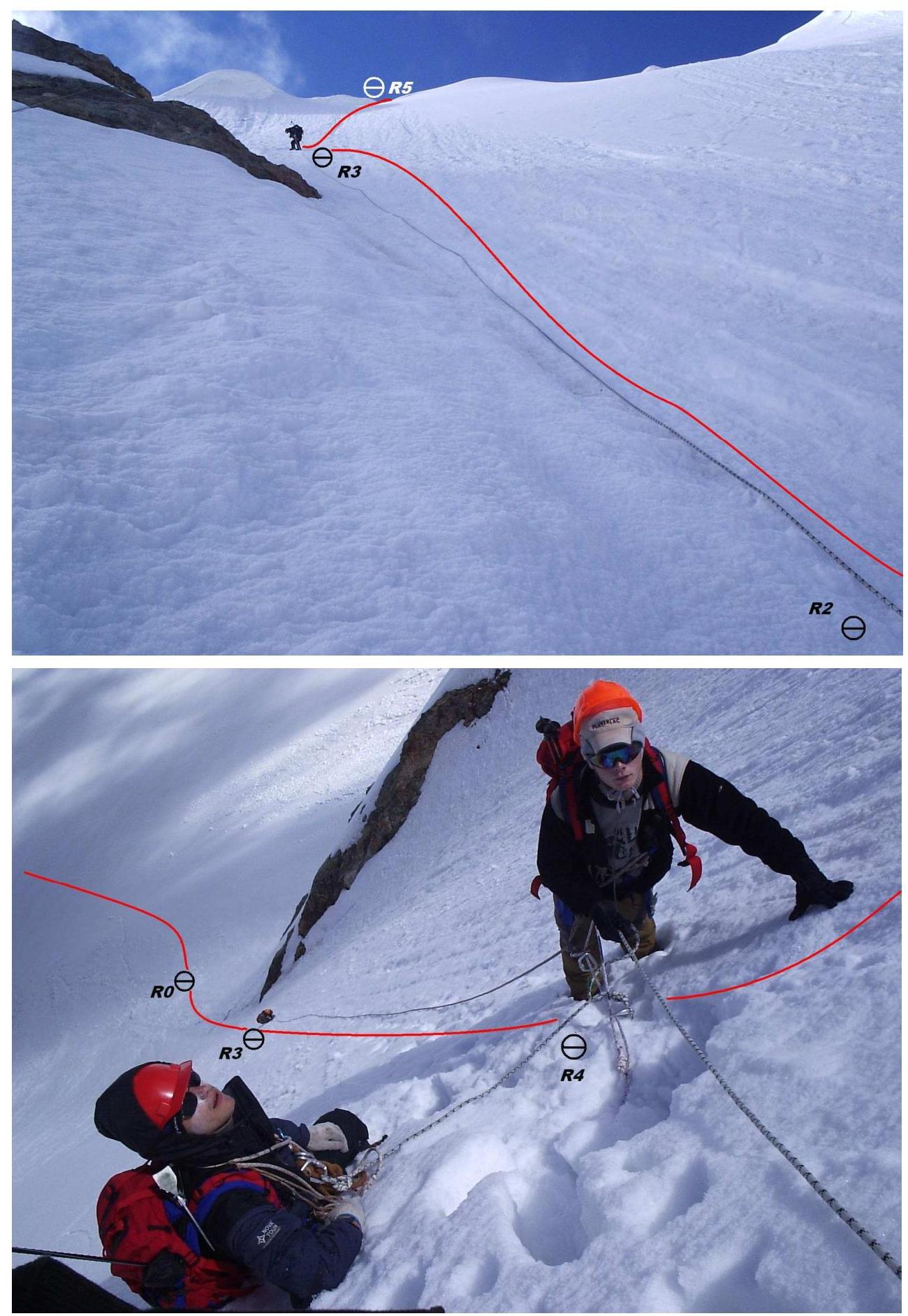
The main part of the route passes along the snowy-icy Northern slope of the Western ridge with a steepness of up to 46° and a length of 254 m. In its upper part, where it joins routes No.22 and No.24, it follows the rocky Western ridge with a highly dissected relief and an abundance of places for belaying and rope fixing on rock outcrops.
A note from a group led by Uvarov I.A. (Pyatigorsk) dated June 13, 2008, was found on the summit cairn.
Throughout the ascent, VHF radio communication was maintained with base camps at "Green Hotel" and with a group led by L.V. Dorfman, which was ascending VIAtaou peak via the Southern ridge, category 2B.
The descent from the summit was made together with the group led by L.V. Dorfman via the ascent route, as the snow cover condition in the Southern couloir (route category 1B) posed a real avalanche threat.
The ascent was made in compliance with safety rules and measures. Based on the route's length, steepness, and relief characteristics, as well as a comparative analysis of similar classified routes, I believe that this route can be rated as category 2A (combined). The best season for the ascent is from late June to September.
From October to early June, the Northern slope of the Western ridge may pose an objective avalanche danger.
Ascent leader: V.F. Shvyransky (cert. 1288).
GPS Data Decoding
| Measurement point designation | Latitude | Longitude | Altitude (m a.s.l.) |
|---|---|---|---|
| BASE — "Green Hotel" bivouac | 43°12,296′ | 42°44,440′ | 2621 |
| 1 — right-bank moraine "pocket" of Djankuat glacier | 43°12,367′ | 42°45,124′ | 2876 |
| TUR1 — control cairn No. 1, moraine | 43°12,843′ | 42°45,709′ | 3362 |
| R0 — route start | 43°12,722′ | 42°45,926′ | 3432 |
| R1 — belay point | 43°12,674′ | 42°45,930′ | 3468 |
| R2 — | 43°12,633′ | 42°45,935′ | 3473 |
| R3 — | 43°12,654′ | 42°45,937′ | 3536 |
| R4 — | 43°12,641′ | 42°45,945′ | 3568 |
| TUR2 (R5) — control cairn No. 2, 3rd ridge saddle | 43°12,634′ | 42°45,949′ | 3612 |
| R6 — | 43°12,640′ | 42°45,973′ | 3606 |
| R7 — | 43°12,643′ | 42°46,006′ | 3622 |
| R8 — | 43°12,646′ | 42°46,029′ | 3646 |
| R9 — | 43°12,635′ | 42°46,047′ | 3672 |
| R10 — | 43°12,644′ | 42°46,078′ | 3694 |
| VIA — VIAtaou peak | 43°12,646′ | 42°46,125′ | 3764 |
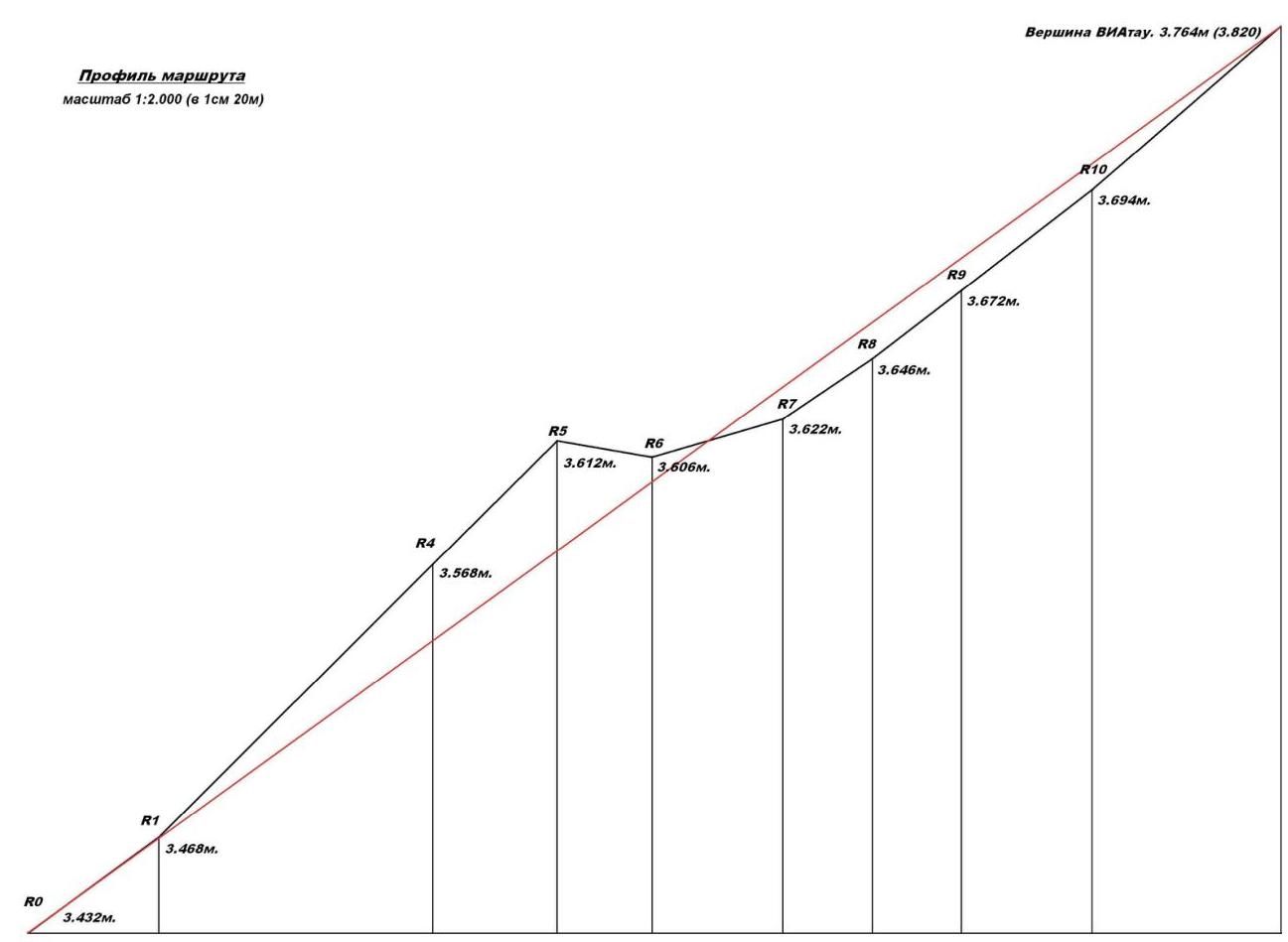
Route Profile Scale 1:2000 (1 cm = 20 m)
VIAtaou peak. 3764 m (3820 m)
UIAA Route Diagram
 1st control cairn
 R2
R2