
PASSPORT
1. Region, gorge, section number according to KMGV-2001:
2.4. From Chipperazau pass to Gumači peak (Baksan gorge).
2. Name of the peak, its height, name of the route:
Azau-Bashi, 3695 m, via the Eastern ridge.
- Proposed category 2A, first ascent.
- Character of the route — combined.
- Height difference of the route — 500 m;
length of the route — 1075 m; there are no sections of V and VI category; average steepness:
main part of the route — 55°;
whole route — 30°.
- No pitons were left on the route. A total of 4 chocks were used on the route.
- Team's climbing hours — 4.5; 1 day.
- Leader: Valery Matveevich Shakalo, Master of Sports of the USSR.
Participant: Yuri Mikhailovich Kuzmenko, 1st sports category.
- Coach: Boris Osmanovich Tilov, Master of Sports of the USSR.
- Departure to the route — August 14, 2003 at 7:00.
Reached the summit — August 14, 2003 at 11:30. Returned to base camp — August 14, 2003 at 15:00.
- Organization: Elbrus Search and Rescue Team of the EMERCOM of Russia.
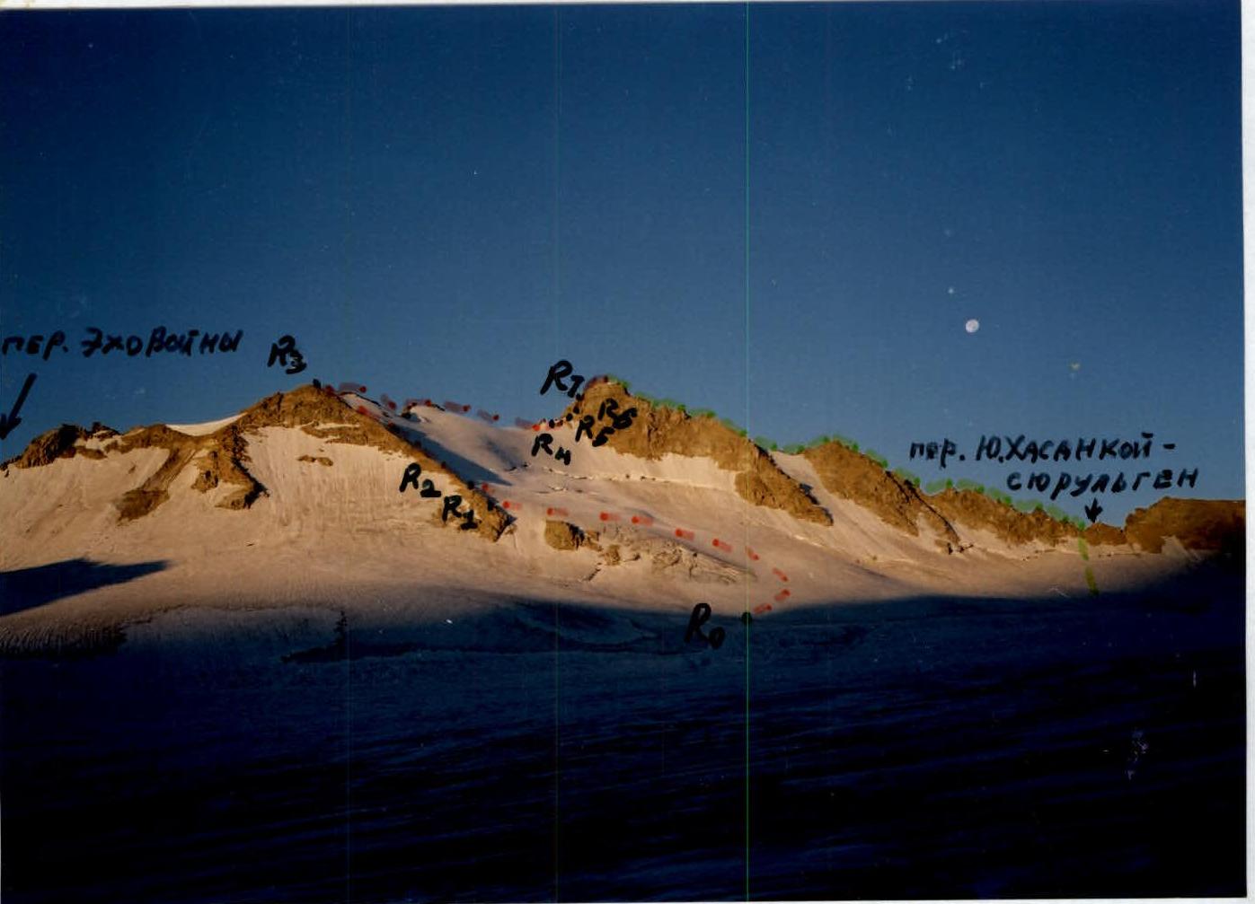
Technical photograph (route profile on the right) and at the same time a photograph of the general view of the peak. (The frontal photo of the general view is not included in the report because the route is obscured by the projection of gendarmes standing on the Eastern ridge, which overlap the peak from all possible shooting points, see e.g. the left profile photo of the route)
- route of the first ascent, submitted in the report
- visible part of the traverse from Khasankoisyurulghen pass to Chipperazau 2B category (N. Bulyon, Yu. Basov, A. Borzunov, A. Kulikovsky, N. Moiseev, August 22, 1947).
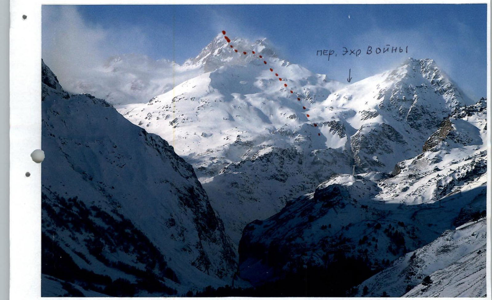
Left profile photo of the route ("Only part of the route on the tower is visible, the rest of the route is obscured by gendarmes, and is also on the other side of the ridge")
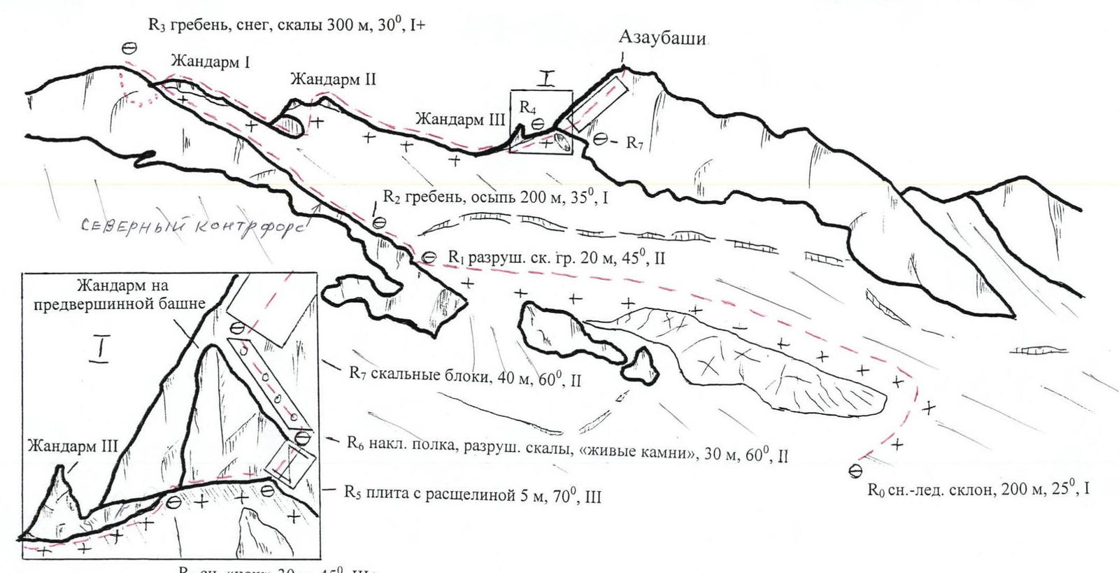
Route diagram in UIAA symbols
Brief description of the route
From the bivouac on the median moraine of the Bolshoi Azau glacier under the Ekho Voyny pass:
- Approach the lower part of the North-Eastern counterfort along the snowy slope, bypassing the open broken glacier from the right and above, and exit onto the counterfort in the area of the destroyed rocks, below its talus part.
- Ascend to the Eastern ridge of Azau-Bashi peak via easy rocks and then talus on the counterfort, going from the Ekho Voyny pass.
- From the top of the counterfort, descend under the first gendarme of the ridge and ascend it from the right along the snow.
- Along the rocky ridge of the gendarme, approach under the second gendarme.
- Ascend the second gendarme from the right along the snow.
- Descend along the rocky ridge of the gendarme onto the long snowy ridge and approach under the third rocky gendarme.
- Bypass the gendarme from the right along the snow and along the sharp snowy knife-edge (belay) approach the summit tower.
- Bypass the gendarme on the tower from the right along a five-meter slab with a cleft (belay), then along an inclined shelf (loose rocks, belay) and ascend to the summit via simple block-type rocks.
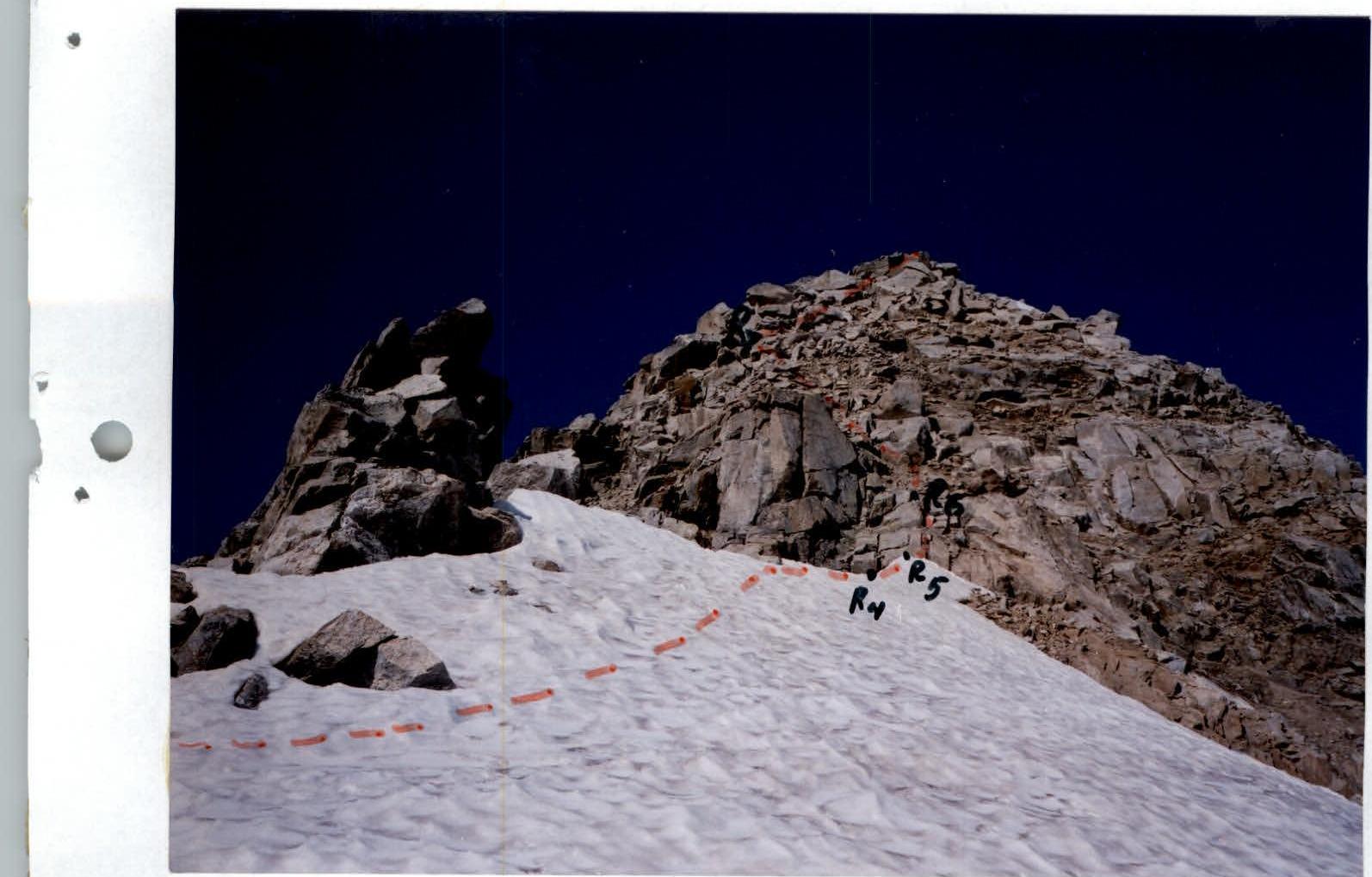
Photograph of the most difficult sections of the route
- R4 — snowy knife-edge
- R5 — slab with a cleft
- R6 — inclined shelf
Recommendations for subsequent groups
Necessary equipment (for a group of 4 people):
main rope 2 × 40 m; loops 2 × 3 m; chock stones (friends) — 4 pcs.; carabiners — 6 pcs.; snow anchors — 3 pcs. (if the route is icy — 6 ice screws);
crampons — for each participant.
Route passage features.
Due to the rockfall hazard of the inclined shelf on the summit tower, gathering of group participants and belaying can be done:
- at the beginning of the "knife-edge"
- at the beginning of the shelf.
Characteristic sign of the start of the route
— broken glacier to the right of the clearly visible long straight North-Eastern counterfort, descending from the middle of the Eastern ridge towards Elbrus. The Eastern ridge connects the Ekho Voyny pass and Azau-Bashi peak.
Conclusion
On the preliminary assessment of the route in comparison with the classified routes of the same half-category of complexity available in the experience of ascents of the participants of this group.
The following routes previously climbed by the participants of the submitted first ascent are generally similar in difficulty and character to the route of this first ascent:
- Combined route to Azau-Bashi peak (3695 m) via the Eastern ridge is equivalent in difficulty to the combined 2A category route to Akhsu peak (3900 m) via the 3rd ridge (Classification of routes to mountain peaks, section 2.4.), but is longer;
- Similar in difficulty to the combined 2A category route to Chotchat peak (3780 m) via the NE ridge (KMRP, section 2.4.1.);
- More technically saturated, but shorter than the combined 2A category route to Tytju peak (2nd Z.) (4420 m) via the 3rd ridge (KMRP, section 2.4.1.);
- Shorter in the steep snow-ice part, but more complex on the rocky sections than the combined 2A category route to Latsga peak (3995 m) from the south via the V couloir of the ridge (KMRP, section 2.4.1.);
- More complex than the combined 2A category route to Machkharapara peak (3530 m) via the 3rd ridge ((KMRP, section 2.5.1.);
- Significantly shorter, but more complex than the combined 2A category route to Rustavi peak (4950 m) from Rustavi glacier (KMRP, section 2.9.);
- Shorter, but more complex than the combined 2A category routes to Manshuk Mametova peak (4194 m) from Mametova glacier ((KMRP, section 7.1.) and Gastello peak (4240 m) from Prizyvnik pass (KMRP, section 7.10.).
RUSSIAN ALPINISM FEDERATION
Dear Vladimir Nikolaevich, Vitaly Vasilyevich!
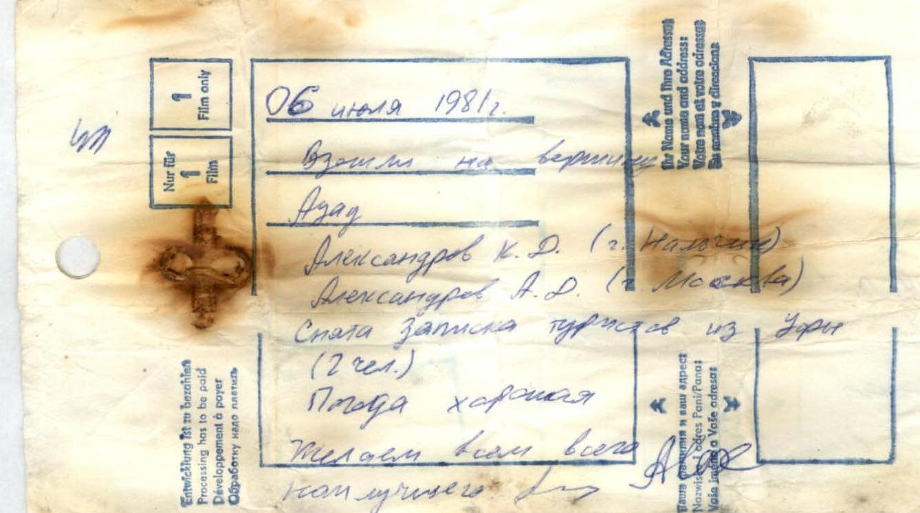
Allow us to explain why we are submitting this report on the first ascent to the pedestrian mission of the Russian Alpiniism Federation. The Azau-Bashi peak, which effectively closes the Baksan gorge, has long been attractive. Its characteristic view from the gorge is shown in the report (left profile photo of the route). There were no descriptions of routes to Azau-Bashi in the classification of routes to mountain peaks. We did not know... We chose what seemed to us the most logical and simple route and made the ascent. There is a note on the summit (it is attached), i.e. the mountain is visited.
July 6, 1981 Ascended to Azau peak Aleksandrov K.D. (Nalchik) Aleksandrov A.D. (Moscow) Also a note from tourists from Ufa (2 people) Weather is good Wish everyone all the best

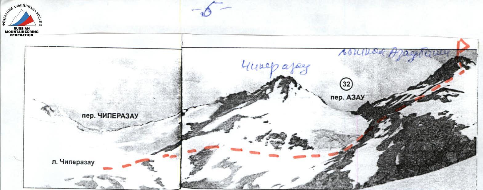
In A.F. Naumov's book "Baksan Valley" "Fizkultura i sport", Moscow, 1972, two routes to Azau peak are mentioned: Azau from Chipperazau glacier, 1A category, and traverse from Khasankhoy-Syurulghen (pass, on modern maps — Khasankoisyurulghen) to Chipperazau, 2B category, which passes through Azau-Bashi peak. The 2B category route is not ours; the chosen part of it is shown by a green dashed line on the technical photograph. And we did not ascend via the 1A category route; it can be decided by You, as You may have materials...
If we have repeated a route, we ask, in accordance with the report materials, to increase its category. In conclusion, we ask to accept the route we have passed into the classification of routes to mountain peaks.
We believe that the 1A category ascent is to a different peak with the same name (See Photo 1 below). You decide...
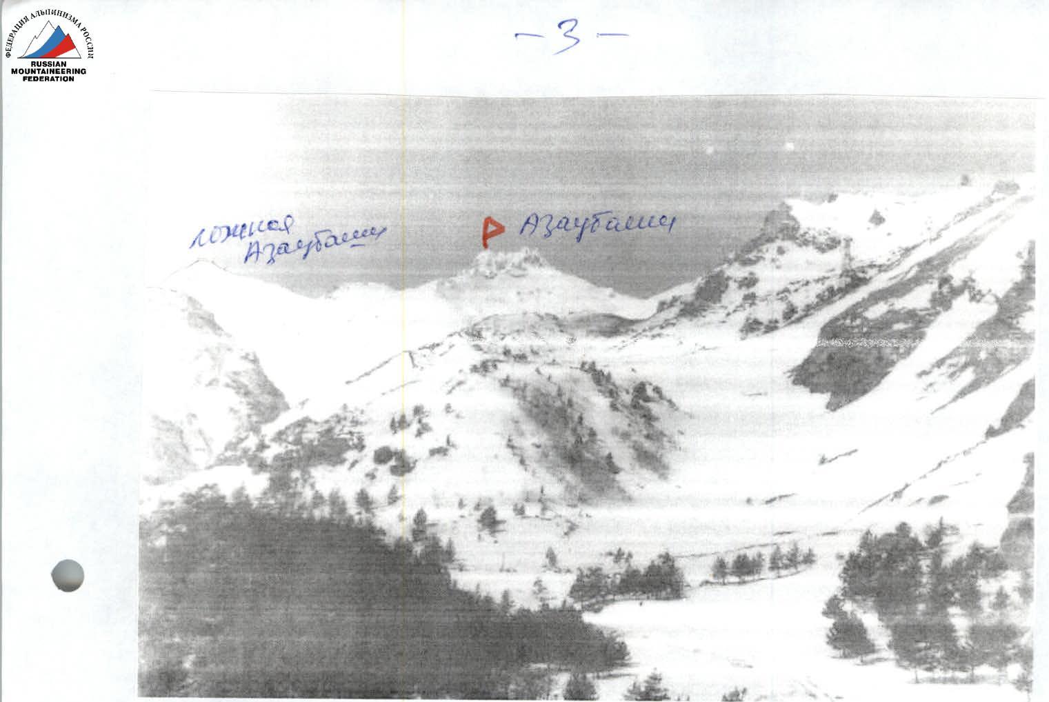
Photo 1. False Azau-Bashi and true Azau-Bashi. The photo was taken in Prielbrusye from the slope above the Azau hotel.


In A.A. Alekseev's book "Elbrus and its slopes", Moscow, publisher I.V. Balabanov, 2002, Fig. 18 (actually — a photo) shows Azau-Bashi peak, which we ascended. The photo was taken from Prielbrusye, from Bolshoi Azau glacier. This photograph matches the technical photograph of our route. The route of our ascent is marked:
Fig. 24a. Upper reaches of the Ulluozhen river

This is the actual Azau-Bashi peak, it is located between the Ekho Voyny and Khasankoisyurulghen passes. Or — Azau-Bashi peak is not marked on all maps... and this peak is sometimes confused...
For persuasiveness, we provide a photograph of the true Azau-Bashi peak from the station of the cable car and...
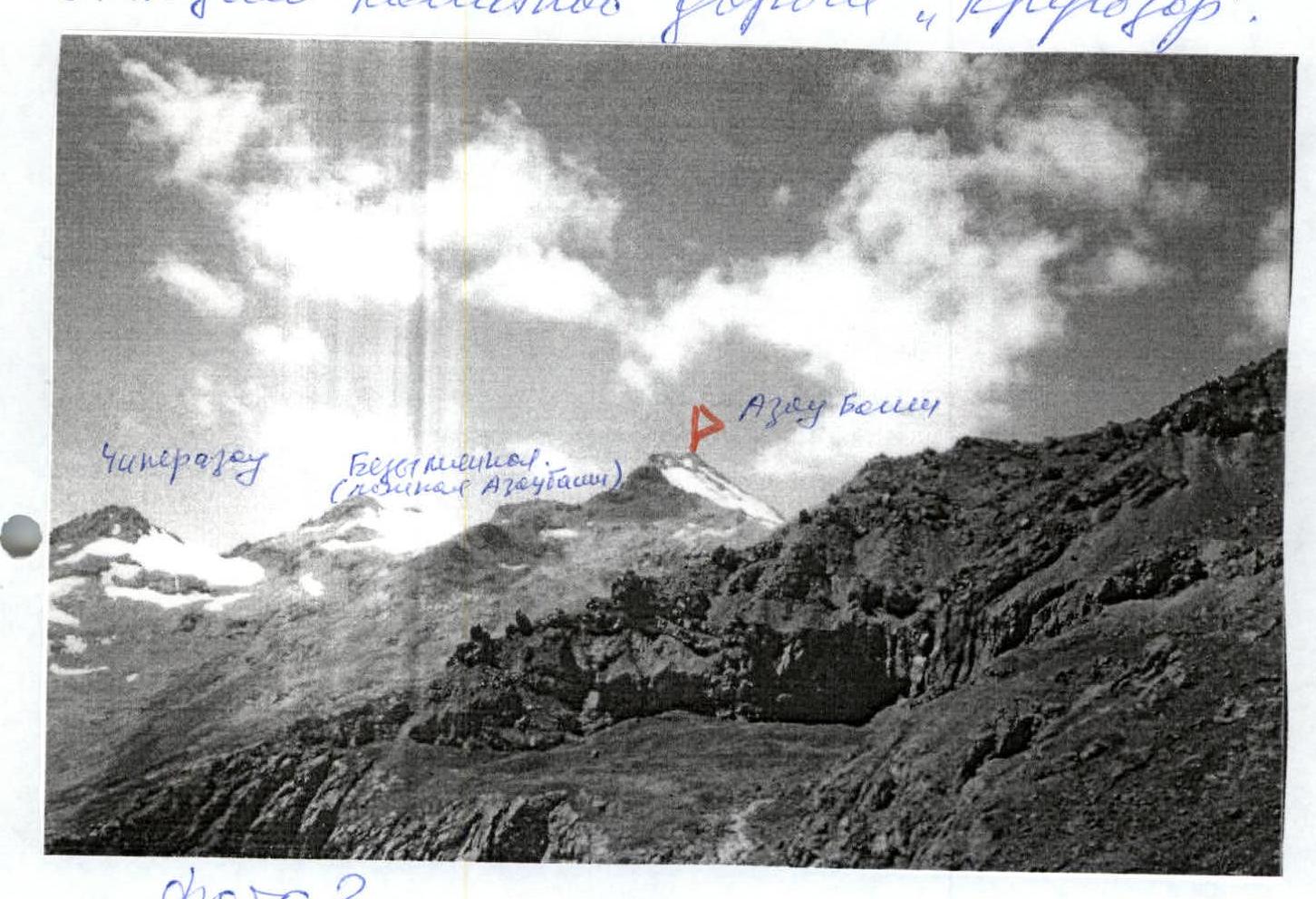
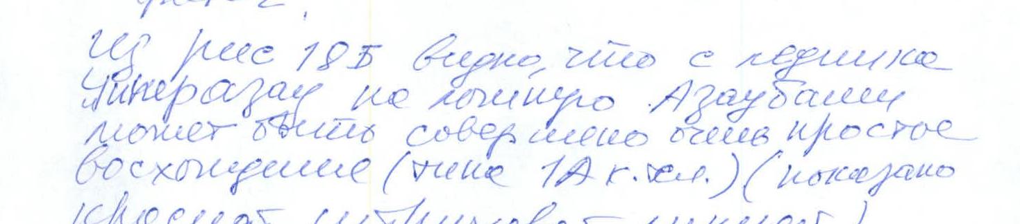
Fig. 186. Cirque of Chipperazau glacier from the Ekho Voyny pass
The true Azau-Bashi peak, which we ascended, is located to the right of the Khasankoisyurulghen pass (marked with a red flag on Fig. 19) to the left of the pass. The green dashed line shows the traverse from Khasankoisyurulghen pass to Chipperazau peak, mentioned in A.F. Naumov's book (see above)...
A.F. Naumov in the book "Baksan Valley" on p. 35 calls the false peak Azau-Bashi...
I am submitting a report on the first ascent to the Russian Alpiniism Federation, although I live in Kiev... as I am a citizen of Russia...
Sincerely, V.M. Shakalo
Comments
Sign in to leave a comment