- Ascent category: technical
- Ascent area: (according to KTMVG) Caucasus. From Chiperezau Pass to Kitlod Pass.
- Summit, its height, and route: Chegem 4461 m via North-West wall - North-East ridge.
- Estimated category of difficulty: 5B
- Route characteristics:
- Height difference: 1250 m
- Average steepness: 55°
- Average steepness of the wall directly: 80°
- Length of sections:
- 1: 0 m
- 2: 405 m
- 3: 625 m
- 4: 93 m
- 5: 385 m
- 6: 273 m
- Number of pitons driven:
| For belaying | For creating artificial points of support | |
|---|---|---|
| Rock | 75 | 28 |
| Ice | 13 | – |
| Bolt | – | – |
- Number of travel hours - 40
- Number of nights and their characteristics: three nights: I - on the glacier under the wall, II - on a narrow rock shelf on the wall, III - on the ridge in a tent.
- Surname, name, patronymic of the group leader, participants, and their sports qualification:
-
- Laskavyi Dalian Pavlovich - Candidate Master of Sports of the USSR
- Shakalo Valeriy Matveevich - Candidate Master of Sports of the USSR
- Prusov Gennadiy Vladimirovich - Candidate Master of Sports of the USSR
- Ryzhikov Sergey Anatolyevich - Candidate Master of Sports of the USSR
- Inyutkin Aleksey Nikolaevich - Candidate Master of Sports of the USSR
- Team coach: senior instructor, Master of Sports of the USSR Popov Viktor Pavlovich. Date of departure and return: 13-16 August 1978.
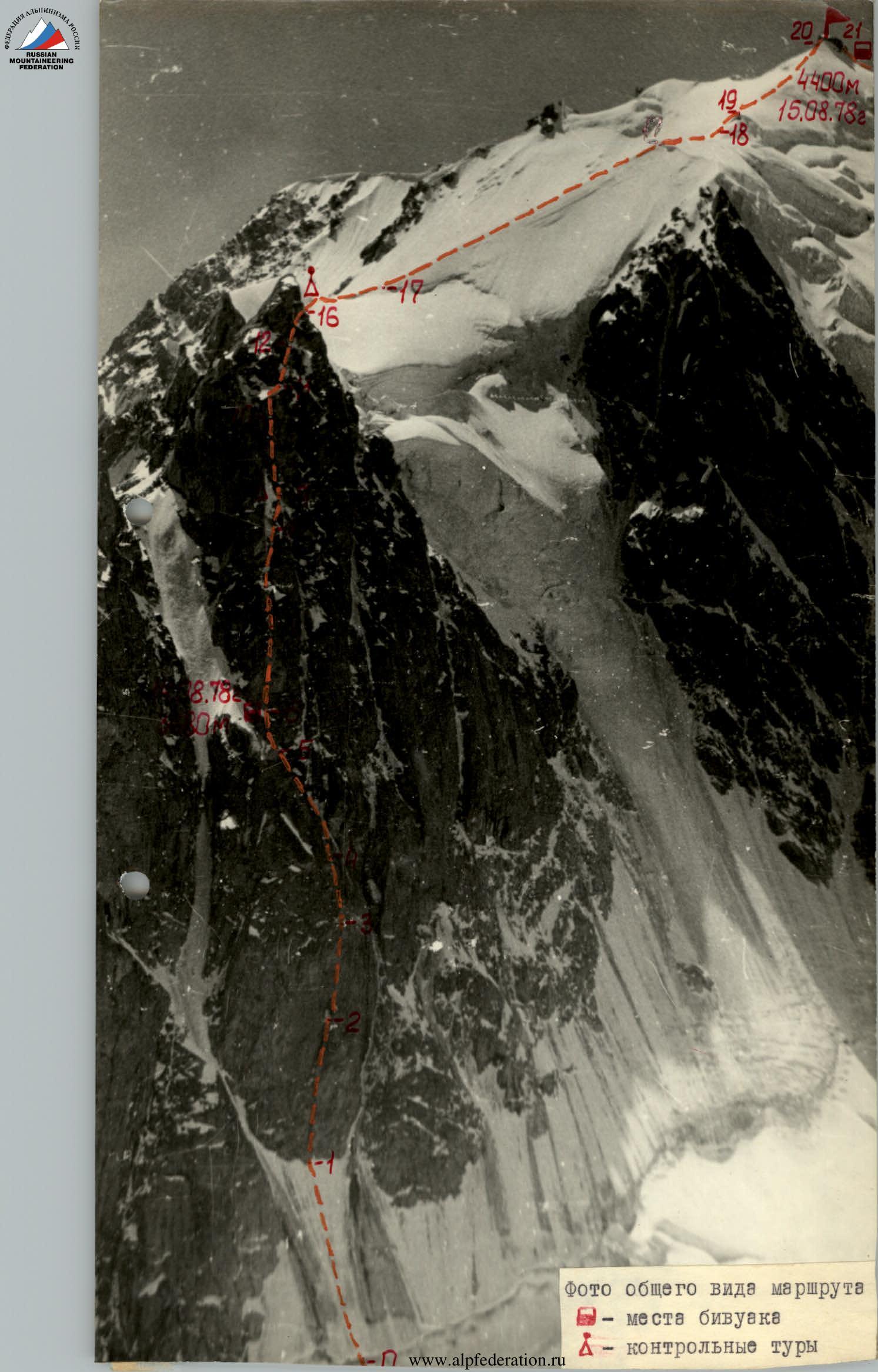
Photo of the general view of the route
Snow knife
Volenyuk moving on the rope on section R1-R2
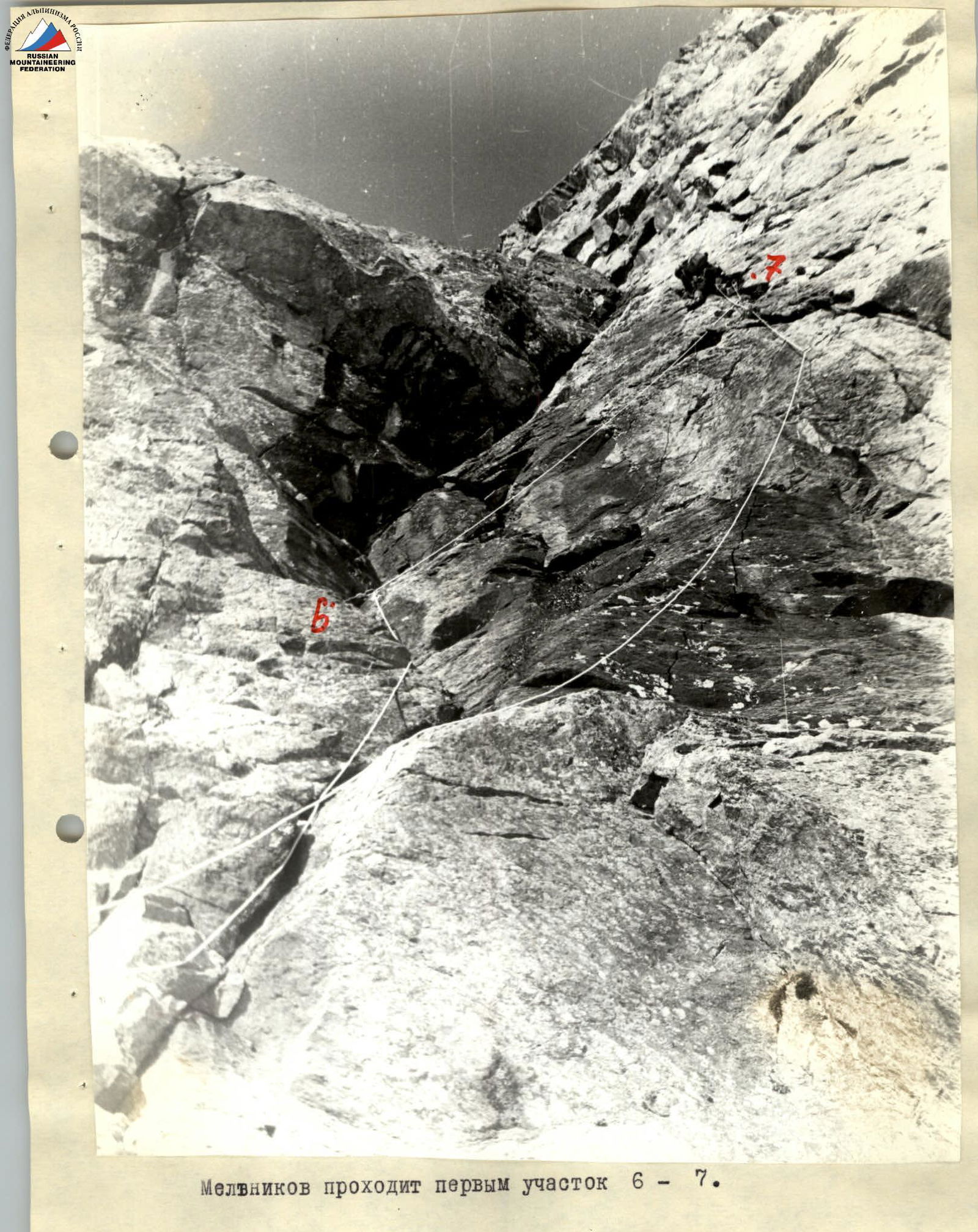
Melnikov passing the R6-R7 section first
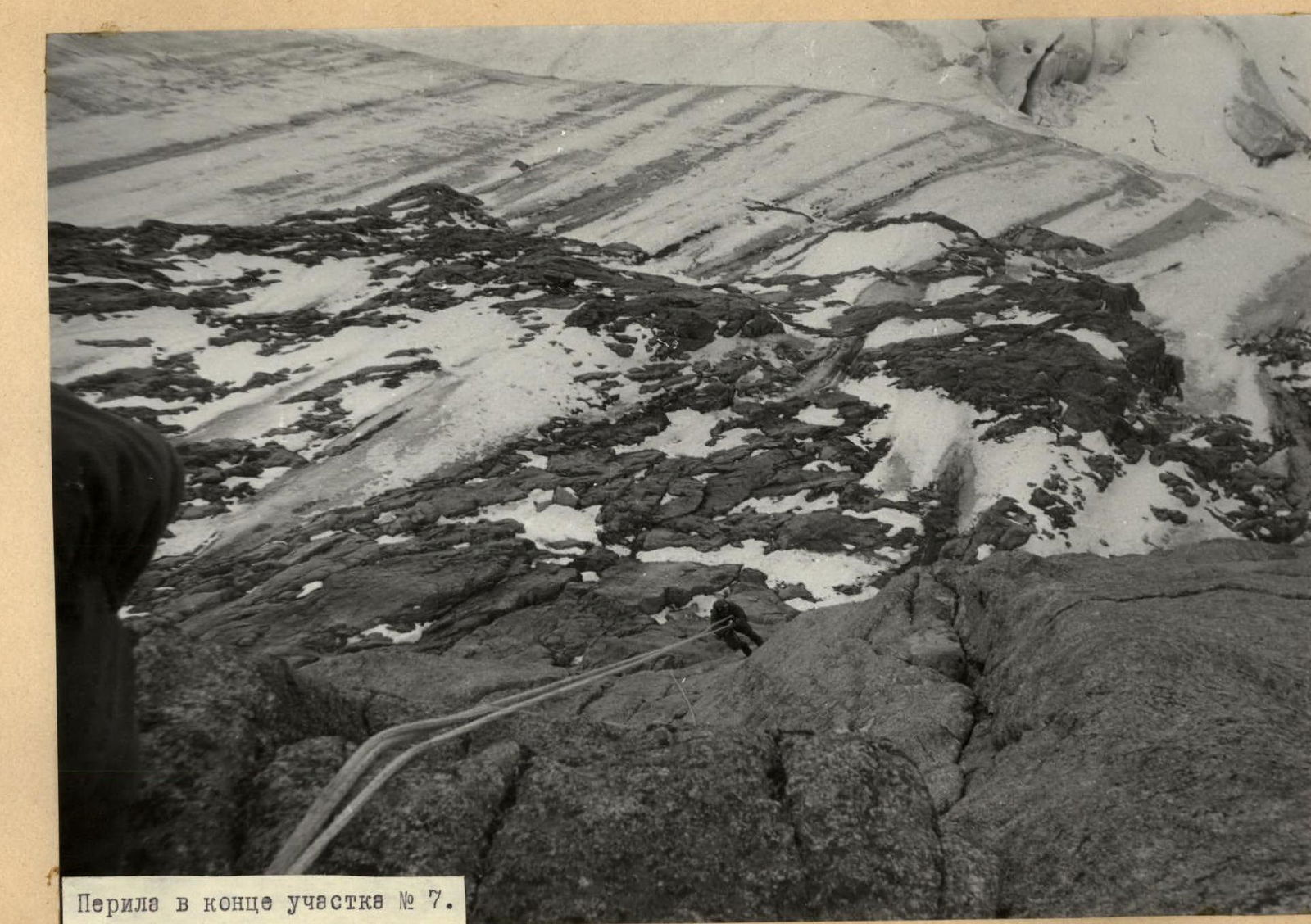
Ropes at the end of section R7
The summit of Chegem is located in the northern spur of the Main Caucasian Range, branching off from Mestia-tau peak. There are three ridges leading to the summit:
- eastern,
- north-eastern,
- western.
Two routes lead to the summit: category 2B via the Bashil-ouz gorge, along the Eastern ridge, and category 3B along the western ridge, from Donkin Pass.
The northern slopes of Chegem end in extended steep ice drops, cut by four rock counterforts. The north-eastern ridge of Chegem ends in a powerful steep rock bastion, along which a route to the Chegem summit was laid in 1977 by a group of climbers from the Djailyk alpine camp, classified as category 5B.
All four counterforts are of interest for ascents. The left northern counterfort, the most powerful, separated by terrain from the previously climbed route 5B category of difficulty, was chosen by a group of instructors from the Djailyk alpine camp and the Adyr-su valley KSP for the first ascent, via a steep through snow-ice couloir.
The ascent along this counterfort was made by the aforementioned group from 13 to 16 August 1978, consisting of:
-
- Laskavyi D.P. - Candidate Master of Sports of the USSR, head instructor of Djailyk alpine camp
-
- Shakalo V.M. - Candidate Master of Sports of the USSR
-
- Prusov G.V. - Candidate Master of Sports of the USSR
-
- Ryzhikov S.A. - Candidate Master of Sports of the USSR
-
- Inyutkin A.N. - Candidate Master of Sports of the USSR, instructor of KSP, checking the group on the route.
Table of route sections
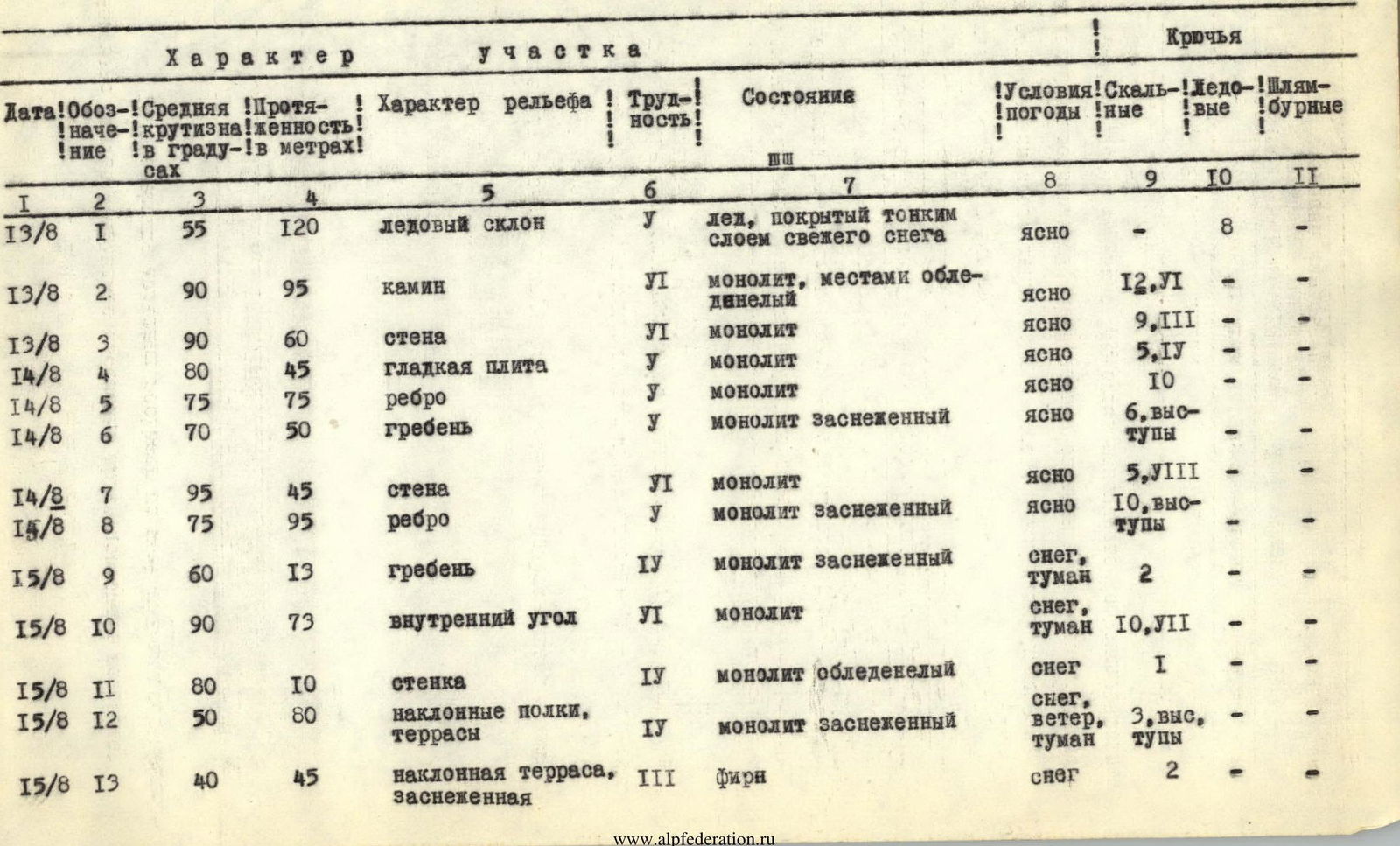
| Date | Section | Average steepness (°) | Length (m) | Terrain characteristics | Difficulty | Condition | Weather conditions | Rock | Ice | Bolt |
|---|---|---|---|---|---|---|---|---|---|---|
| 13/8 | R1 | 55 | 120 | ice slope | I | ice covered with a thin layer of fresh snow | clear | – | 8 | – |
| 13/8 | R2 | 90 | 95 | chimney | VI | monolith, partially iced | clear | 12, VI | – | – |
| 13/8 | R3 | 90 | 60 | wall | VI | monolith | clear | 9, III | – | – |
| 14/8 | R4 | 80 | 45 | smooth slab | I | monolith | clear | 5, IV | – | – |
| 14/8 | R5 | 75 | 75 | edge | I | monolith | clear | 10 | – | – |
| 14/8 | R6 | 70 | 50 | ridge | I | monolith snow-covered | clear | 6, ledges | – | – |
| 14/8 | R7 | 95 | 45 | wall | II | monolith | clear | 5, VIII | – | – |
| 15/8 | R8 | 75 | 95 | edge | I | monolith snow-covered | clear | 10, ledges | – | – |
| 15/8 | R9 | 60 | 13 | ridge | IV | monolith snow-covered | snow, fog | 2 | – | – |
| 15/8 | R10 | 90 | 73 | inner corner | VI | monolith | snow, fog | 10, VII | – | – |
| 15/8 | R11 | 80 | 10 | small wall | IV | monolith iced | snow | I | – | – |
| 15/8 | R12 | 50 | 80 | inclined ledges, terraces | IV | monolith snow-covered | snow, wind, fog | 3, ledges | – | – |
| 15/8 | R13 | 40 | 45 | inclined snow-covered terrace | III | firm snow | snow | 2 | – | – |
| 15/8 | R14 | 30 | 50 | wide inclined snow-covered terrace | III | firm snow | snow, wind, fog | simultaneous movement | – | – |
| 15/8 | R15 | 40 | 40 | ridge | III | monolithic rocks alternating with snow | snow, wind, fog | simultaneous movement | – | – |
| 15/8 | R16 | 50 | 30 | ice slope | IV | ice covered with a thin layer of snow | wind, fog | – | 3 | – |
| 15/8 | R17 | 35 | 55 | snow ascent | III | deep fresh snow on ice | wind, fog | simultaneous movement | – | – |
| 15/8 | R18 | 33 | 350 | snow ridge | III | deep fresh snow, partially ice | wind, fog | simultaneous movement | – | – |
| 15/8 | R19 | 50 | 40 | ice slope | IV | ice partially covered with fresh snow | wind, fog | – | 2 | – |
| 15/8 | R20 | 40 | 100 | snow ridge | III | deep snow | wind | simultaneous movement | – | – |
| 15/8 | R21 | 60 | 30 | rock edge | III | monolith partially snow-covered | wind | belay via ledges | – | – |
Brief explanation of the table of route sections.
From the bivouac above the icefall, descend along the right orographic side of the glacier to under the North-West counterfort of the North-East ridge of Chegem peak. Cross the bergschrund under it - a steep bastion of the counterfort. From the bergschrund, along steep ice (section R1, 120 m), approach the counterfort, to the base of a vertical chimney. Then ascend along monolithic, iced, difficult (partially overhanging) rocks on the right side of the chimney (section R2, 95 m; ladders, artificial points of support) to a snow-covered balcony. Here, a bivouac is possible. From the balcony, move upwards along a steep, difficult, 60-meter wall to the right of the chimney (section R3) with an exit to a steep slab (ladders, artificial points of support are used, backpacks are pulled up). The ascent from the bergschrund took 12 hours. Having equipped the route up to this point, the group descended and spent the night at the previous location, ascending to the rope anchorage point in the morning.
Along monolithic, smooth, difficult rock slabs (ladders, artificial points of support, the first person goes without a backpack), ascend upwards-left to the level of a large snowfield on the left (section R4, 45 m).
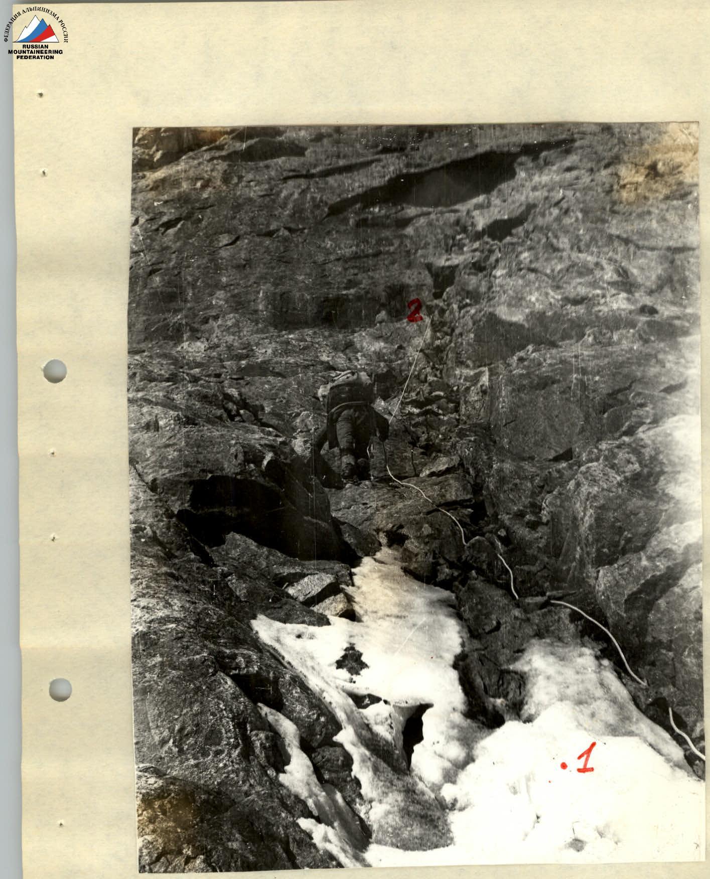
Along moderately difficult, partially difficult rocks of a vaguely defined edge (section R5, 75 m), exit onto a steep snow-covered ridge, along which (section R6, 50 m) approach the base of the wall. Here, a bivouac was organized. From the balcony bivouac, it took 10 hours. The wall partially overhangs. It is climbed on the right side, with very difficult climbing, in climbing shoes, using artificial points of support, on ladders, backpacks are pulled up. Section R7, 45 m long, was pre-processed by a pair, until stopping for the night. The wall leads to a steep edge, interrupted by snow-covered ledges. Further ascent was made along the same edge, turning into a ridge (section R9, 13 m), to the base of a vertical inner corner. Here, the first control cairn was installed.
From this point onwards, movement along the route was carried out in poor weather conditions (snowfall, fog, wind).
A 78-meter inner corner was climbed along difficult and very difficult overhanging rocks on its left wide side, using artificial points of support and ladders. Backpacks were pulled up (section R10).
After exiting the corner, it is necessary to overcome a 10-meter iced rock wall (section R11) and cross a sloping snow terrace located under it from left to right.
From the terrace, along a snow-covered, steep, partially interrupted inclined ledge, moving right-upwards, exit onto a second terrace, encircling the North-West counterfort on the right.
From the second terrace, moving left-upwards, along inclined, partially snow-covered ledges, exit onto a third inclined snow-covered terrace, encircling the tower of the counterfort on the right (section R12, 80 m). Bypass the tower along the snow terrace on the right (section R13, 45 m) and exit onto a wide inclined snow-covered terrace, ending on the left with a ridge (section R14, 50 m). From the terrace, ascend onto a monolithic, sloping, rock, partially snow-covered ridge (section R15, 40 m).
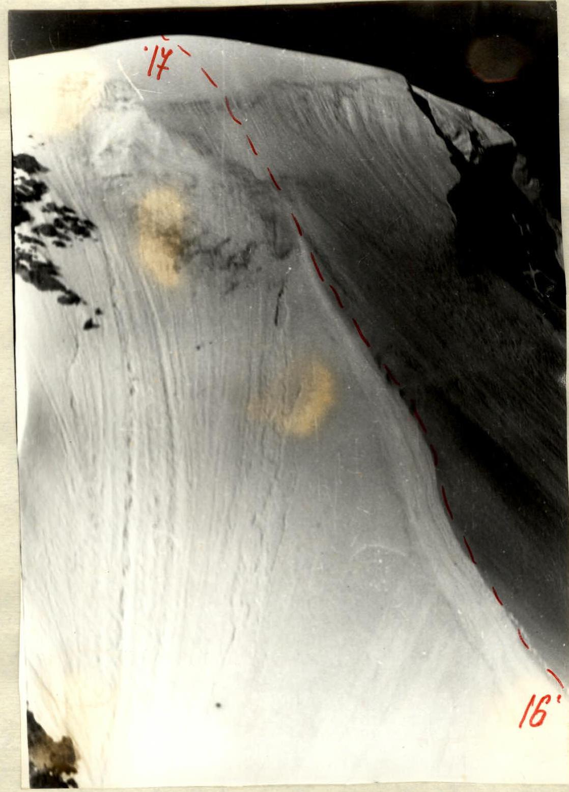
The last rock gendarme on the ridge is bypassed on the left along steep ice (section R16, 30 m). On the rock slab behind the gendarme, a second control cairn was installed. The ridge leads to a snow ascent (section R17, 55 m), along which the ascent to the North-East ridge of Chegem peak was made. Along the snow ridge (section R18, 350 m), ending with a steep ice ascent with a series of crevasses (section R19, 40 m), then along a snow pre-summit ascent (section R20, 100 m), approach the summit tower. Overcome the tower's rocks on the left (section R21, 30 m) and exit onto the summit. From the balcony bivouac - 15 hours.
The next night was organized on the descent. The descent from the summit was made along the Western ridge (route category 3B), to Donkin Pass, and further - along the path to the camp.