The summit of Ullu-Tau (4207 m) is located in the Main Caucasian Range and closes the Adyr-Su gorge.
The summit is an array located in the East-West direction and has three not clearly defined peaks: Eastern, Main, and Western. The highest point of the massif is the Main peak of Ullu-Tau.
To the north, the massif drops off with a steep wall with significant glaciation. The height difference is over 1200 m. All technically complex routes on the massif pass along the northern walls and are combined. Eight routes of category 5B have been laid on the massif (all along the northern walls).
For the ascent, the group chose a new route through a steep rocky outcrop located between the rocky bastions of the Eastern and Main peaks.
From the "Dzhailyk" alpine camp, past the "Ullu-Tau" alpine camp, up the gorge for 3 hours to the moraine under the northern wall of Ullu-Tau Main ("Central bivouac").
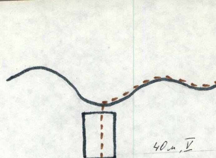
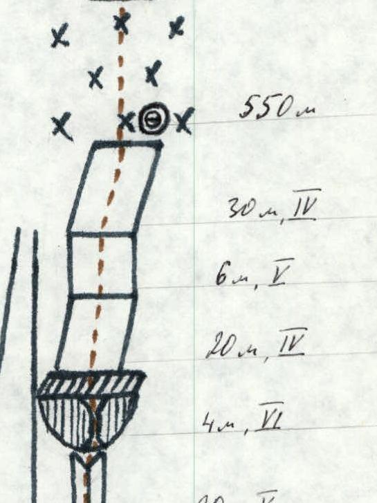
Table of Main Characteristics of the Ascent Route

Table of Main Characteristics of the Ascent Route (Continued)
| Date | Designation | Average steepness, ° | Length, m | Terrain characteristics | Difficulty | Condition | Weather conditions | Rock pitons | Ice pitons | Bolt pitons |
|---|---|---|---|---|---|---|---|---|---|---|
| 1 | 2 | 3 | 4 | 5 | 6 | 7 | 8 | 9 | 10 | |
| 28 August 1980 | R0–R1 | 55° | 550 m | Steep snow-ice slope | 4 | Hard firn | Night, clear, frost | 6 | — | — |
| R1–R2 | 75° | 20 m | Not clearly defined outer corner | 5 | Flow ice | Dawn, clear | 6 | 2 | — | |
| R2–R3 | 80° | 40 m | Rocky ridge | 6 | Destroyed rock with flow ice | Clear | 13 | 5 | — | |
| R3–R4 | 70° | 40 m | Rocky wall with a ledge, control cairn | 5 | —, snow | Clear | 9 | — | — | |
| R4–R5 | 65° | 15 m | Rocks | 5 | Destroyed, covered with snow and flow ice | Clear | 5 | — | — | |
| R5–R6 | 80° | 5 m | Rocky wall | 6 | Monolithic smoothed rocks with flow ice | Clear | 2 | 1 | — | |
| R6–R7 | 65° | 20 m | Not clearly defined inner corner | 5 | Destroyed rocks, flow ice | Clear | 7 | — | — | |
| R7–R8 | 93° | 24 m | Overhanging wall with a chimney and a ledge at the top | 6 | Icy rocks | Clear | 3 | 2 | — | |
| R8–R9 | 50° | 20 m | Inclined slab | 4 | Snow-covered | Clear | 2 | — | — | |
| R9–R10 | 65° | 6 m | Rocky wall | 5 | Covered with snow and ice | Clear | 3 | — | — | |
| R10–R11 | 60° | 30 m | Rocky slope | 4 | Clear | 5 | — | — | ||
| 29 June 1980 | R11–R12 | 60° | 400 m | Steep snow-ice slope | 4 | Ice covered with a thin layer of snow | Wind, fog, cold | — | 2 | — |
| R12–R13 | 65° | 150 m | Steep ice slope | 5 | Ice | — | 16 | — | ||
| R13–R14 | 70° | 40 m | Rocks | 5 | Icy, snow-covered | 8 | — | — | ||
| R14–R15 | 30° | 160 m | Pre-summit rocky ridge | 3 | Rocks covered with snow | Strong wind, fog, snow | 1 | — | — |
Total travel time: 23 hours 30 minutes
Description of the Route
From the "Central" bivouac, the group departed at 1:00 on August 28, 1980. After crossing the Ullu-Tau glacier, the group approached under the bergschrund of the Northern wall between the Eastern and Main Ullu-Tau peaks. Section R0–R1.
After passing the first and second bergschrunds, they reached a rocky-ice slope leading under the rocky "outcrop." They approached under the "outcrop" at 5:30.
Section R1–R2. The "outcrop" is a steep rocky bastion dissected by vertical, ice-filled, and snow-clogged gullies. For the ascent, they chose the right part of the bastion to the right of the right gully, which was steeper but less filled with ice and snow and less hazardous.
Beginning of the section:
- About 20 m straight up along a not clearly defined outer corner (flow ice).
- To the left — a gully.
- To the right — smoothed slab-like rocks (in-situ anchor).
Section R2–R3. Then 40 m along the left side of the corner (destroyed rocks, flow ice) to a small inclined ledge for one person (in-situ anchor).
Section R3–R4. From the ledge upwards about 40 m to the next ledge (flow ice). Control cairn.
Section R4–R5. From the control cairn 15 m to a destroyed ledge (flow ice).
Section R5–R6. From the ledge 5 m along monolithic smoothed rocks to an inner corner (flow ice, in-situ anchor).
Section R6–R7. Then 20 m along the corner under an overhanging wall (flow ice).
Section R7–R8. The wall is ascended via a chimney (flow ice) and leads to a snow-covered ledge (in-situ anchor).
Section R8–R9. From the ledge to the right upwards 20 m along inclined snow-covered slabs under a large rocky ledge with a wall.
Section R9–R10. The ledge is overcome directly head-on along the wall.
Section R10–R11. Then snow-covered rocks (30 m) lead to a snow-ice ridge (reached at 17:00). They dug out a platform in the ridge, reinforced it with snow, and organized a bivouac. From the "Central" bivouac to the ridge — 16 hours. June 29, 1980.
Section R11–R12. From the bivouac, they departed at 3:00. From the ridge straight up in the direction of the saddle between the Main and Eastern peaks, initially along a steep ice slope dusted with snow, 400 m.
Section R12–R13. Then the steepness increases, and another 150 m along the ice slope under the rocky belt of the main ridge of the massif.
Section R13–R14. Exit to the saddle of the ridge along steep icy and snow-covered rocks 50–60 m.
Section R14–R15. From the saddle to the right 140–160 m to the summit of Ullu-Tau Main. They reached the summit at 10:30. From the bivouac above the outcrop 7 hours 30 minutes.
From the summit, they descended by traversing along the ridge through the summit of Ullu-Tau Western to the Garvash pass, and then through:
- "Cheget" bivouac
- Adyr-Su gorge
- "Dzhailyk" alpine camp