PASSPORT
- Snow and ice class.
- Caucasus, Adyrsu gorge.
- "Ullutau" massif, via the rock islands of the Northern wall and the Western ridge (Maltsev's route), category 5B.
- Elevation gain: 717 m length: 935 m, length of sections: 500 m, category 5, average steepness of the main part of the route 65°.
- Pitons driven: rock: 19/0; bolt: 0+1x/0; chocks: 5/0; ice screws: 137/0.
- Team's travel hours: 13.5 hours.
- Overnights: 1st on the ridge on a site in a tent, 2nd on the ridge on a site in a tent.
- Leader: Nikolai Petrovich Kiselyov, Candidate Master of Sports.
- Participants: Yuri Grigorievich Kalagin, Candidate Master of Sports
- Vladimir Sergeevich Lukyanov, Candidate Master of Sports
- Pavel Alexandrovich Moshkin, Candidate Master of Sports
- Viktor Ivanovich Radchenko, Candidate Master of Sports
- Coach: Alexander Valentinovich Rasskazov, Master of Sports.
- Started the route: July 23, 1965. Reached the summit: July 23, 1965. Returned: July 25, 1965.

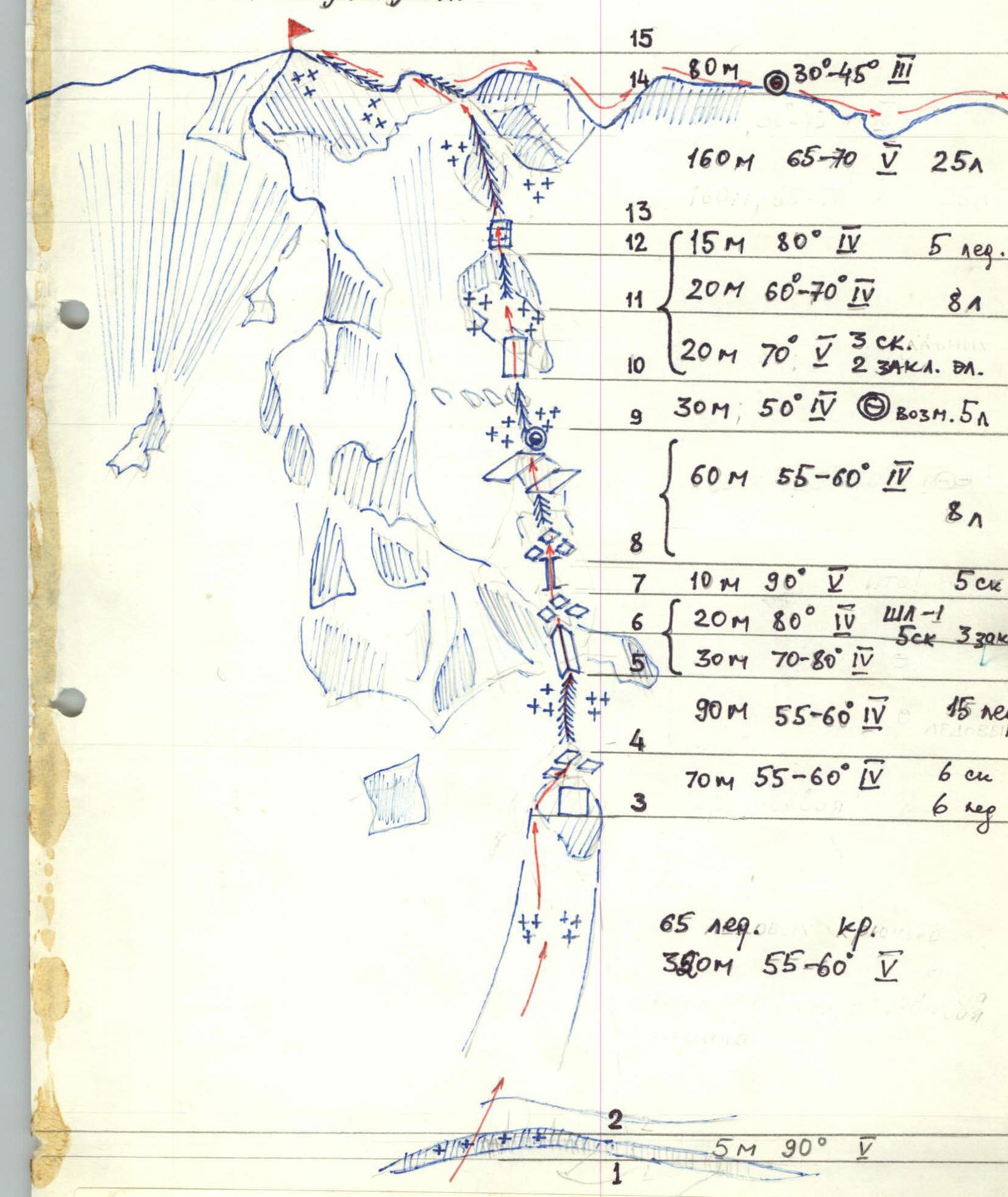
Route description by sections
R0–R1: Movement along the glacier from the bivouac at "Hut" to the bergschrund - simultaneous in rope teams. The first person goes on a full rope length due to many crevasses.
R1–R2: Overcoming the bergschrund is not very difficult as it is filled with snow at the crossing point, and the snow wall leading from it is easily traversed with ice axes. Movement is alternate, insurance through ice axe. The bergschrund was crossed under the "Rhombus".
R2–R3: From the bergschrund begins a snow-ice slope 330–350 m, 50–60°, category 5 technical difficulty. Movement is alternate, 65 ice screws were used.
R3–R4: Movement along rocks with piton belay.
R4–R5: From the 1st to the 2nd rock island - 90 m snow-ice ridge, not clearly defined, 55–60°, category 4 technical difficulty, 15 ice screws were used.
R5–R6: The rope team Moshkin - Kalagin moved here. Rocks are heavily destroyed and covered with fresh snow, 50 m, 10–30 m, category 4 technical difficulty, 5 rock pitons, 3 chocks, a previously hammered bolt was used.
R6–R7: Vertical icy rock chimney 10 m, 90°, category 5 technical difficulty, 5 rock pitons were hammered. Other team members traversed this section via top-rope belay.
R7–R8: Snow-ice slope 60 m, 55–60°, category 4 technical difficulty, 5 ice screws. Exit to the summit of the 2nd rock island, where there is a site for an overnight stay and a control cairn is located.
R8–R9: Snow-ice ridge 30 m, 50°, category 4 technical difficulty, 3 ice screws and ice axes were used.
R9–R10: Snow-ice slope with separate small rock islands 55 m, 60–70°, category 4-5 technical difficulty, 3 rock pitons, 5 ice screws, and 2 chocks were used.
R10–R11: Ice wall. Movement with piton belay.
R11–R12: Ice-snow ridge-slope 160 m, 65–70°, category 5 technical difficulty. 25 ice screws were used during the passage.
R12–R13: Rocky ridge 70–80 m leads to the summit of Ullutau Main. Belay via rock outcrops.
On the entire route, except for R5–R6, all team members worked alternately as the first, and the belay of the first was done through a separate piton.
Tactical actions of the team
According to the tactical plan, the team started the route from the central overnight stays on July 23 at 3:00.
At 4:00, they approached the bergschrund, which they crossed via a snow bridge and a small snow wall (2.5–3 m) under the rhombus. Movement was alternate, insurance through ice axe. Then, along the ice-snow slope (section R2–R3), using 65 ice screws, they approached the avalanche ice gully before the first rock island. With increased attention and thorough belay, they overcame the gully and traversed the first rock island along the ice-snow slope and rocks on the left side (section R3–R4). Further, along the 90 m ice-snow ridge, they approached under the rock wall of the second rock island (section R4–R5). Movement was simultaneous, piton belay.
The rope team Moshkin - Kalagin, alternating, processed 60 m of complex rocks (sections R5–R7). The particularly difficult section was R7, where top-rope belay was used, the only one on the entire route. In these sections, 10 rock pitons were hammered, 3 chocks, and an ice screw and a bolt left by previous groups were used. Further, along the snow-ice slope with rock outcrops - the 3rd rock island (sections R8–R14), they reached the ridge at 16:00.
All team members worked as the first, constantly replacing each other. Ice screws were screwed in every 5–8 m.
Leaving their backpacks on the ridge, the team descended to the summit of Ullutau Main, which they reached at 16:45.
After descending to their backpacks, they began their descent along the ridge towards Garvash pass.
The weather deteriorated sharply: snow, fog, strong gusts of wind.
Due to the fact that two teams were descending ahead of us, which could occupy overnight sites, and considering the late time and worsening weather, at 19:00 the team stopped for the night on the ridge.
July 24 - the second day made adjustments to the tactical plan. Via radio communication at 10:40, we were advised to wait for the other teams to continue the descent to Garvash pass together. At 12:45, we visually saw that the teams we were waiting for were descending to Mestia pass.
After packing up the bivouac, we continued our descent to Garvash pass at 13:30. The bad weather, which continued at night and during the day, and the large amount of snowfall made our descent difficult and slow. At 20:30, before the descent couloir from the West summit, we stopped for the night.
On July 25, at 8:00, we continued our descent. At 10:30, we were at Garvash pass and at 14:00, we were at the Ullutau alpine base.
Safety measures on the route included:
- an early start on the route, which minimized rockfall and avalanche danger;
- the first person working on a double rope;
- rotation of the lead climber to avoid overloading the first;
- reliable radio communication;
- presence of other groups in the area.