Passport
-
Snow-ice class
-
Main Caucasus Range from Chipperaza pass to Kitlod pass
-
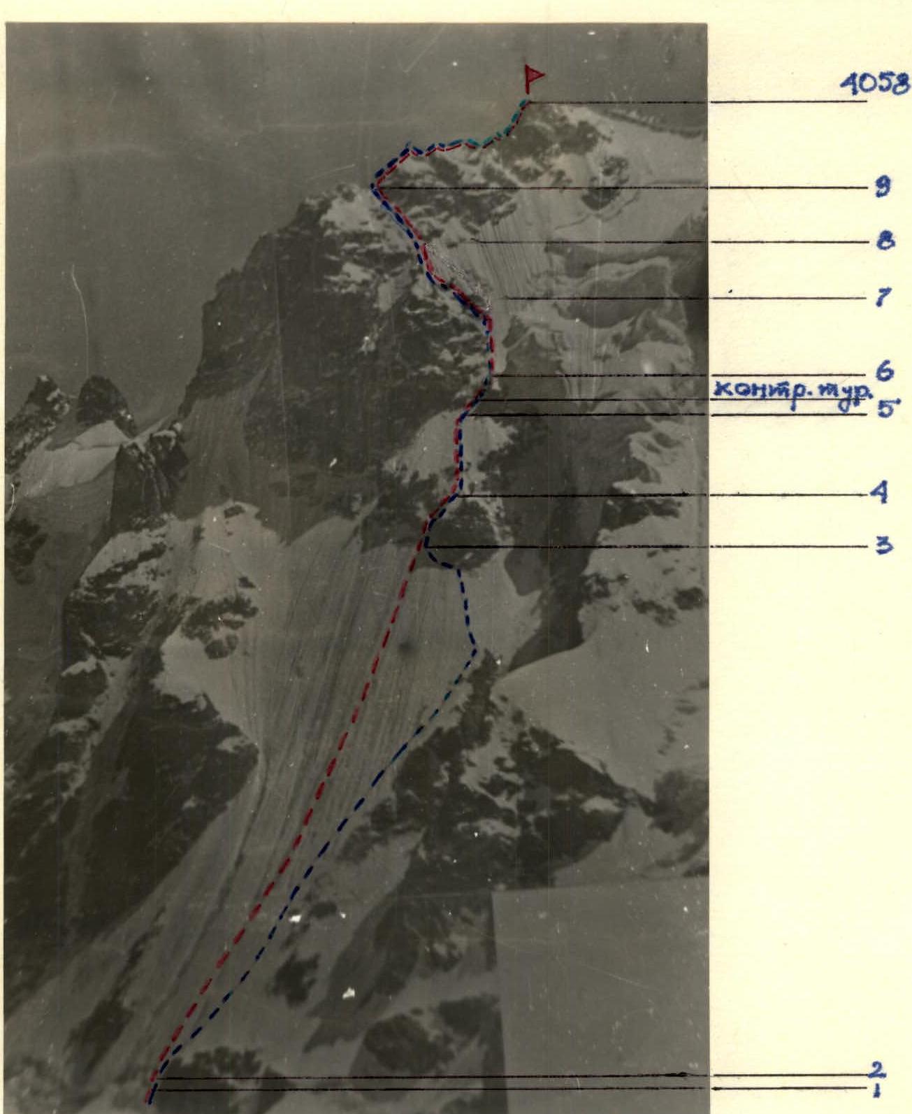
ULLUTAU Eastern peak (4058 m) via the right edge of the North face of the Eastern shoulder
-
Complexity category 5B
-
Height difference: 950 m, route length — 1200 m. Length of sections with 5–6 complexity category — 1120 m. Average steepness of the main part of the route: 54°
-
Pitons hammered:
| rock | bolt | chocks | ice screws |
|---|---|---|---|
| 1х | - | 21 | 183 |
x — previously hammered pitons were used. 7. Team's travel hours — 10 hours. 8. Overnights: 1st site for 4 people. 9. Leader — Izmailov Viktor Nikolaevich, Candidate Master of Sports.
Team members:
- Sokolov Gleb Anatolyevich, Candidate Master of Sports
- Nikolaev Vladimir Nikolaevich, Candidate Master of Sports
- Samsonov Vladimir Anatolyevich, Candidate Master of Sports
- Coach — Izmailov Viktor Nikolaevich.
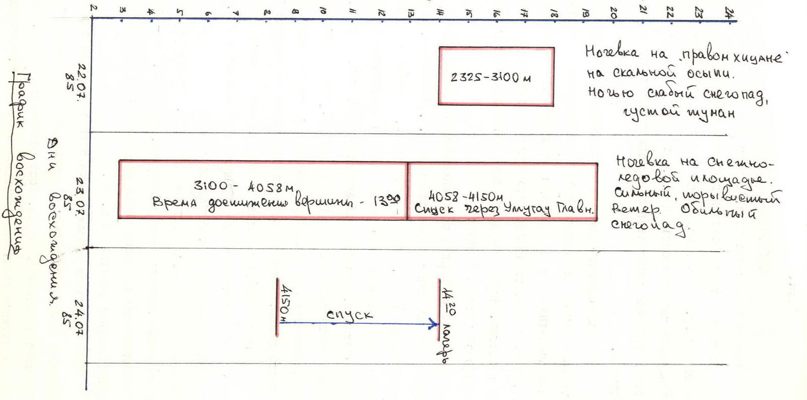
- Approach to the route: July 22, 1985. Summit: July 23, 1985. Return to camp: July 24, 1985.
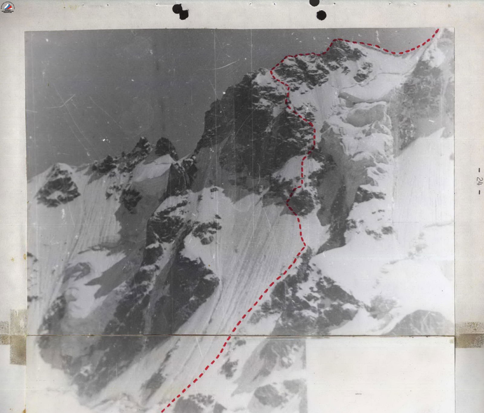
PHOTO 5. View of the first ascent route from Mestian overnight stays.
First ascent route. Team's route.
Preparation for the Ascent
The team obtained information about the route to v. Ullutau Eastern (4058 m) via the right edge of the North face of the Eastern shoulder at the CSP in the Adyrsu valley. To familiarize themselves with the route, the team studied the report on the ascent led by A.V. Artamonov to the aforementioned peak and received consultation on this route from the head of CSP, V.P. Petukhov.
Before the ascent, the team participated in a competition on ice technique as part of the RSFSR championship in the snow-ice class. They also passed the physical and technical training standards for the championship. The data from these standards was documented in a protocol and submitted to the jury.
The choice of route was determined by the results of the ice technique competition "Shnole".
The tactical plan for the ascent was determined based on the data from the report on the ascent led by A.V. Artamonov, as well as after consulting with the head of CSP, V.P. Petukhov. Due to the unstable weather observed in the area during the team's stay, and considering that large ice avalanches can sometimes block the lower part of the route even in warm weather, and that the lower sections are prone to avalanches and rockfalls from the upper destroyed walls of the Eastern shoulder after snowfalls, the departure for the route was set no later than 3:00.
The route is characterized by a large extent of ice and snow (about 1200 m), classified as 5th category of difficulty. Therefore, the team prepared for traversing long and significantly steep ice sections (up to 70°). Equipment was prepared for the passage of this route (crampons, ice screws, ice axes). The team's interaction was practiced during training: conditions for traversing ice sections of 5th category of difficulty.
During preparation for the ascent, the following safety measures and their provisions were determined:
- a) early departure to the route;
- b) thorough study of the route description, possible overnight stay locations, and descent options;
- c) provision of personal protective gear to participants (helmets, harnesses, goggles);
- d) medical monitoring of participants' condition before the ascent;
- e) measures for informing about the group's status (radio communication);
- f) equipment ensuring increased protection of the group from potential complications on the route due to weather conditions and participants' state (bivouac equipment, food supply, gasoline, first-aid kit).
Ascent Hours
Tactical Actions of the Group
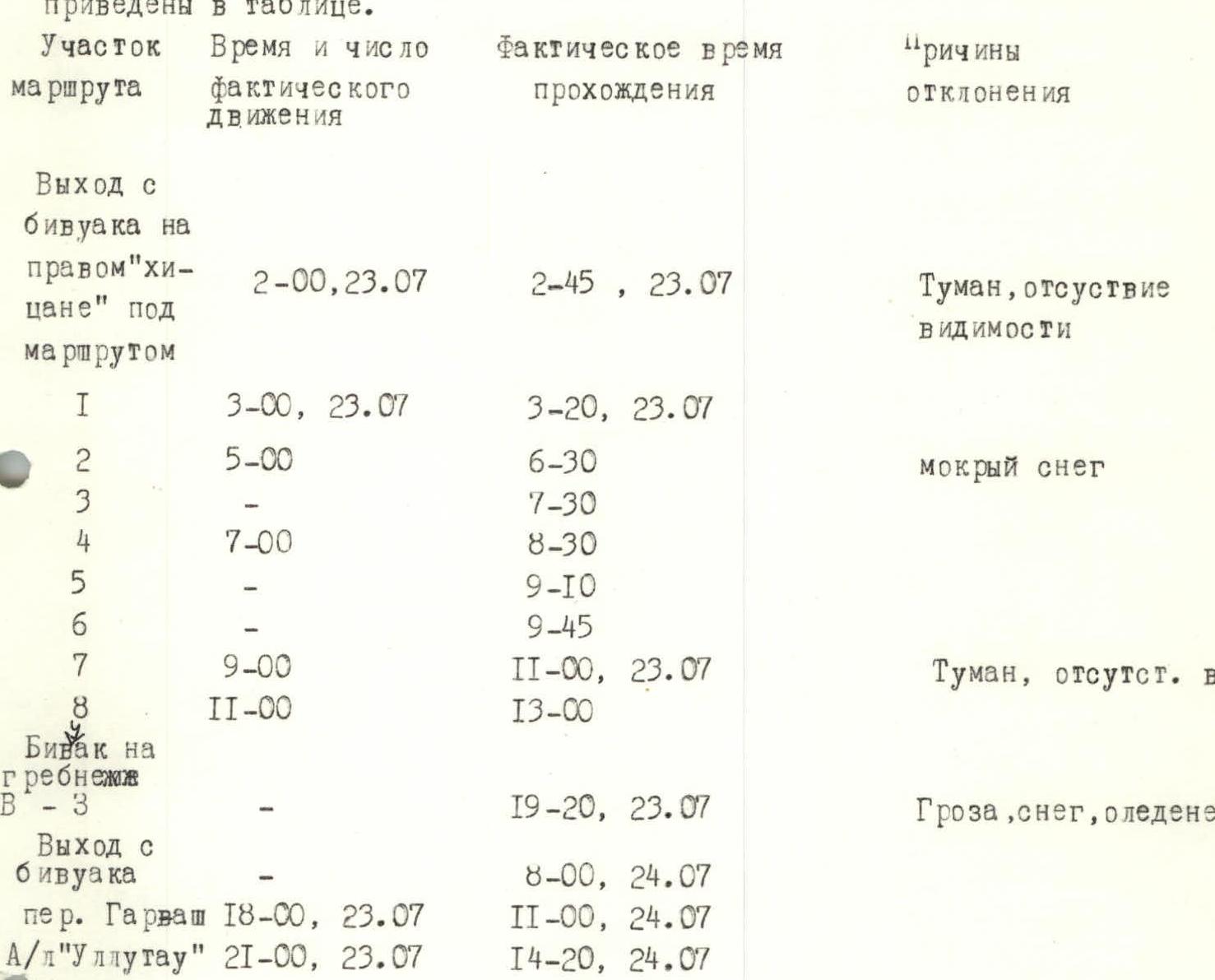
The tactical plan for the ascent, deviations from the tactical plan, and reasons for deviations in the corresponding sections of the ascent and descent route are given in the table.
| Route Section | Time and number of actual movement | Actual time of passage | Reasons for deviation |
|---|---|---|---|
| Departure from bivouac on the right "hitsane" under the route | 2:00, July 23 | 2:45, July 23 | Fog, lack of visibility |
| R1 | 3:00, July 23 | 3:20, July 23 | |
| R2 | 5:00 | 6:30 | Wet snow |
| R3 | 7:30 | ||
| R4 | 7:00 | 8:30 | |
| R5 | 9:10 | ||
| R6 | 9:45 | ||
| R7 | 9:00 | 11:00, July 23 | Fog, lack of visibility |
| R8 | 11:00 | 13:00 | |
| Bivouac on the ridge v. Ullutau 3 | 19:20, July 23 | Thunderstorm, snow, icing | |
| Departure from bivouac | 8:00, July 24 | ||
| per. Garvash | 18:00, July 23 | 11:00, July 24 | |
| A/l "Ullutau" | 21:00, July 23 | 14:20, July 24 |
The rope teams were organized as follows: V. Izmailov — G. Sokolov, V. Nikolaev — V. Samsonov. The rope teams worked autonomously on the Adyrsu glacier and on the ridge of the Ullutau massif. On the route from sections R1–R8, fixed ropes were organized. Work in the rope team was distributed as follows:
- Leaders worked in turns: V. Izmailov and G. Sokolov;
- Third worked: V. Samsonov;
- Fourth worked: V. Nikolaev. Rest periods of 50 minutes and 1 hour were taken respectively on sections R7 and R8 of the route due to lack of visibility.
Bivouacs were organized:
- on the right "hitsane" under the route;
- on the ridge of v. Ullutau Western, 8 m below the ridge.
During the ascent, the following safety measures were taken:
- early departure to the route;
- study of route sections before starting the passage;
- notification of observers (radio communication);
- availability of equipment ensuring increased protection of the team from potential surprises (bivouac equipment, first-aid kit, food supply).
There were no falls or injuries in the team. No non-standard technical приемы were used. Ice screws can be considered new equipment samples.
In bad weather conditions, the team's actions were as follows:
- departure from the bivouac on the right "hitsane" to the route was delayed by 45 minutes due to lack of visibility in the fog;
- on section R7 of the route, the ascent was suspended for 50 minutes due to lack of visibility;
- descent from v. Ullutau 3 was stopped due to thunderstorm conditions, and the group set up a bivouac 10 m below the ridge at 19:20–20:00;
- descent from v. Ullutau Eastern to the snow saddle was suspended for 1 hour due to thunderstorm conditions;
- departed from the bivouac v. Ullutau 3 at 8:00 due to thunderstorm conditions, wind, snow, and icy rocks.
Communication with observers was carried out using the "Karat" radio station. The communication was of poor quality due to thunderstorms and the characteristics of the radio station itself.
Pitons
| rock | bolt | chocks | ice screws |
|---|---|---|---|
| 1х | - | 21 | 183 |
| - | - | 4 | 17 |
| - | - | - | 20 |
| - | - | - | 24 |
| - | - | 7 | 5 |
| - | - | - | 26 |
| 1х | - | 10 | - |
| - | - | - | 88 |
| - | - | - | - |
| Travel hours — 10 | |||
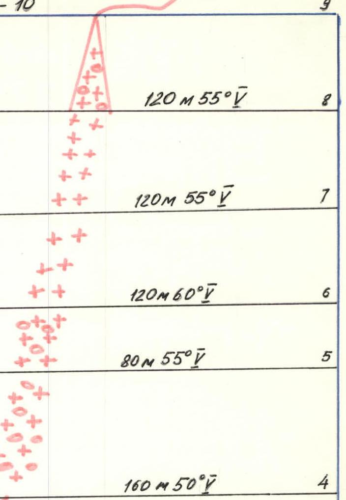 |
- R9: 120 m 55°
- R8: 120 m 55°
- R7: 120 m 60°
- R6: 80 m 55°
- R5: 160 m 50°
- R4: 80 m 60°
- R3: 550 m 50°
- R2: 10 m 75°
- R0: 70 m 40°
Route Description
From the bivouac on the right "hitsane" along the glacier to section R1, representing an avalanche cone under the bergschrund between two rocky islands.
Section R2 — bergschrund is passed on the right side of the snow plug (for safety reasons) with the help of ice screws.
Section R3 — snow-ice slope of about 50° is traversed along avalanche gullies to the base of the rocky island. Everywhere there is hard-packed snow, firn, and brittle ice; insurance through ice screws.
Section R4 — the rocky island represents heavily destroyed rocks with flow ice. Overcome along the inner corner. Insurance through chocks.
Section R5 — rocky scree covered with a layer of ice 5–10 cm thick. On top — a layer of loose snow with a thin ice crust. Insurance is difficult. Ice screws with tension are used.
Section R6 — destroyed rocks in the snow. Control cairn on the wall on a piton.
Section R7 — pure hard ice. Recommendations:
- Move while clinging to the rocks;
- (For safety reasons, beware of avalanches).
Section R8 — ascent to the left upwards along the snow-ice slope to the base of the snow-ice couloir between the "finger" and the rocky wall.
Section R9 — snow-ice couloir with an exit to the rocks. Insurance with ice screws and chocks. Exit to the ridge. Insurance through an ice axe.
Section R10 — further along the ridge in the direction of the Eastern peak of Ullutau. Insurance is simultaneous and alternating through outcrops.
Everywhere from section R2 to section R9, movement is along fixed ropes according to the scheme:
- The first on a double rope organizes a reception point and receives the second with upper insurance;
- The second, moving along the fixed ropes, brings the rope and free pitons to the first, stands on self-arrest organized by the first, and through the first's self-arrest releases the first forward on a double rope;
- The third moves along the fixed ropes with lower insurance;
- The fourth ascends along the fixed ropes with upper insurance, unscrewing ice screws.