Report on the Second Ascent
Dulnev's Route, Tyutyu 2nd Western peak via the left part of the South face of the South ridge.
Assumed 5B category of difficulty.
Multidisciplinary Mountaineering Club "FREELINE", Pyatigorsk.
Passport
- Class: technical.
- Central Caucasus, Kullumkol gorge.
- Tyutyu 2nd West via the left part of the South face of the South ridge, 4420 m.
- Assumed 5B category of difficulty, second ascent.
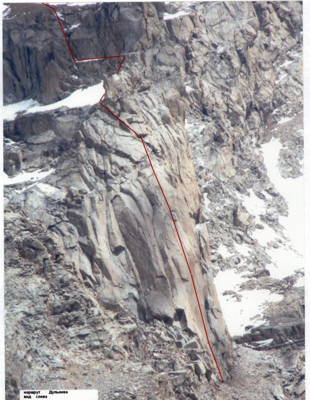
- Height difference: 920 m, length — 1100 m. Length of 5th category difficulty sections — 105 m. Length of 6A–6B category difficulty sections — 95 m. Average steepness of the main part of the route is 75°. Overall route steepness — 45°.
- Hooks left on the route — 0 pcs., including: bolted hooks — 0 pcs. Hooks used on the route: stationary bolted hooks — 8 pcs., including 4 for artificial aids. removable bolted hooks — 13 pcs., including 9 for artificial aids. Total artificial points of support used — 69.
- Team's climbing hours: 15 hours and 1 day.
- The group did not make any overnight stops on the route.
- Leader:
ascent as a duo:
- Oleg V. Shestak — 1st sports category;
- Mikhail L. Popov — 1st sports category.
- Coach: Nikolai I. Motienko — Candidate Master of Sports, instructor II category.
- Departure to the route: July 25, 2007, 6:00 AM. Summit — July 25, 2007, 9:00 PM. Return — July 26, 2007, 1:00 AM.
- Organization: Mountaineering Club FREELINE.
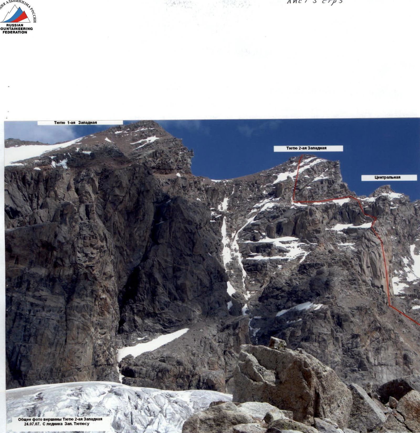
Red line — Dulnev's Route. Yellow line — Ryzhikov's Route, 5A category of difficulty. July 24, 2007, from Zapadny Tyutyusu glacier.
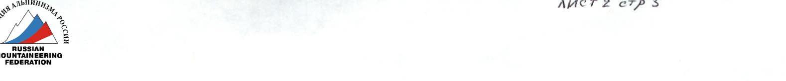
Profile of the wall from the right.

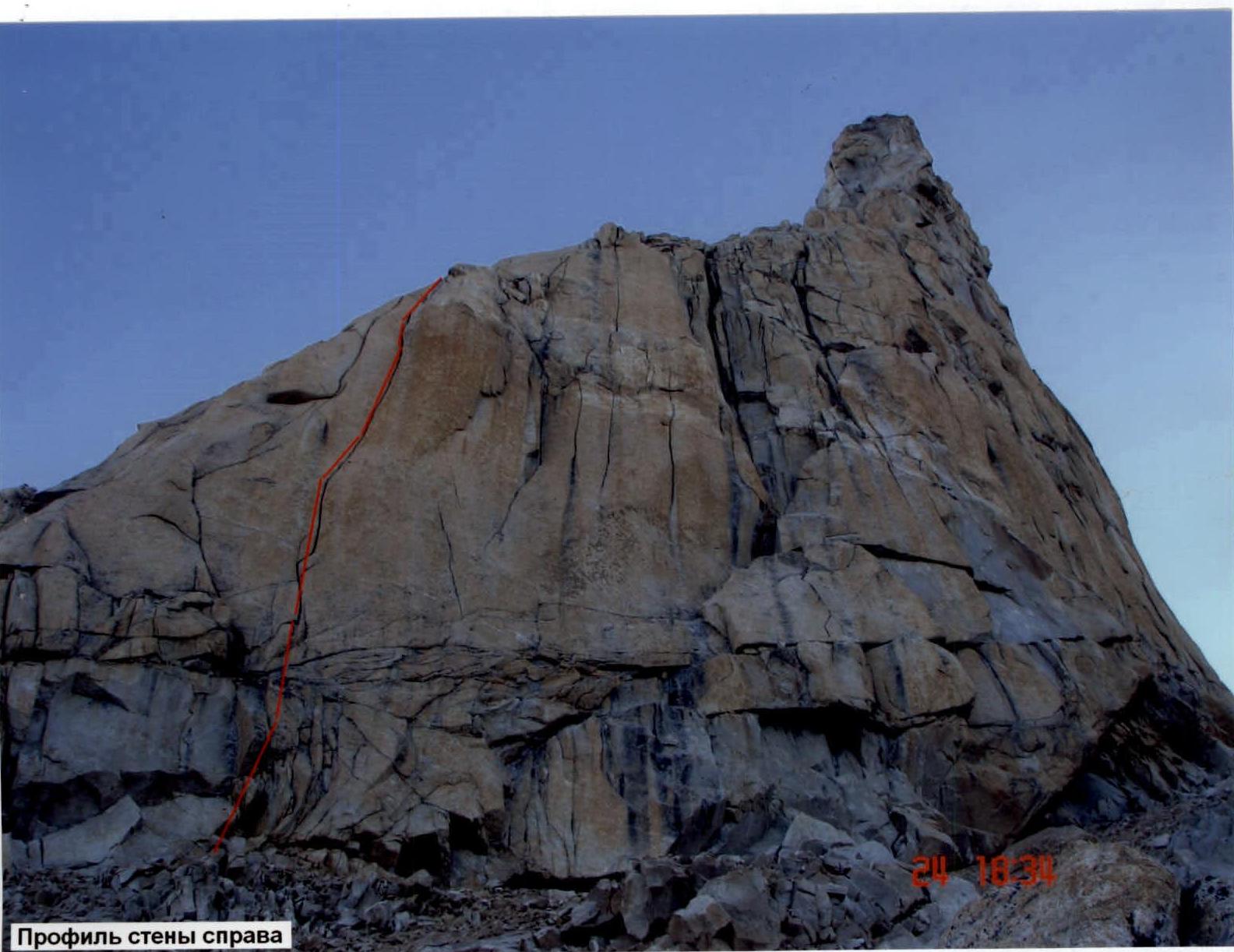
Dulnev's Route. View from the left.
Overview of the Climbing Area
The Tyutyu massif is located in the western spur of Djailik, which is a nodal point for the Tyutyu-su, Adyrsu, and Chegem gorges. It is situated between the Djailik peak to the east and the Sullukol peak to the west.
Approach to the Area
From Tyrnyauz, 30 km to the village of Verkhny Baksan. From the highway, turn left towards the car lift. Then, 20 km along a good dirt road along the Adyrsu gorge to the Ullutau alpine camp.
Approach to the Base Camp
From the Ullutau alpine camp, go back 2 km and turn right into the Kullumkol river gorge. Cross to the left bank of the river via a wooden bridge at the beginning, then follow it for 6 km until a sharp ascent to the left towards the "paradise campsite". From the campsite, ascend gradually, veering left. Then, the trail sharply turns up to the left and leads to the moraine, which bounds the Zapadny Tyutyu glacier to the left. There are campsites on the moraine.
Approach to the Route
From the campsite, follow along the glacier, gradually crossing it from right to left in the direction of the 2nd Western Tyutyu peak. Directly opposite the peak, there is a pronounced snow-ice couloir leading to a 200-meter smooth wall — the beginning of the route. There are crevasses on the glacier.
General photo of the Tyutyu 2nd Western peak on July 24, 2007, from the Zapadny Tyutyusu glacier.
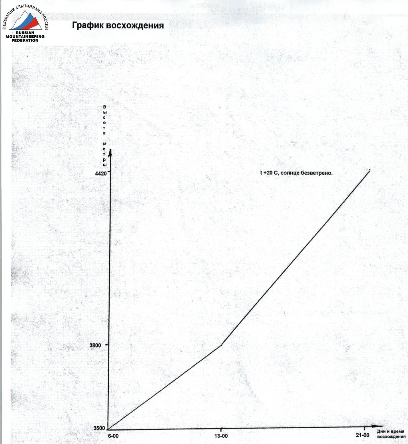
Ascent graph.
 Climbing days — 1, climbing hours — 15 (as of July 25, 2007).
Route Description
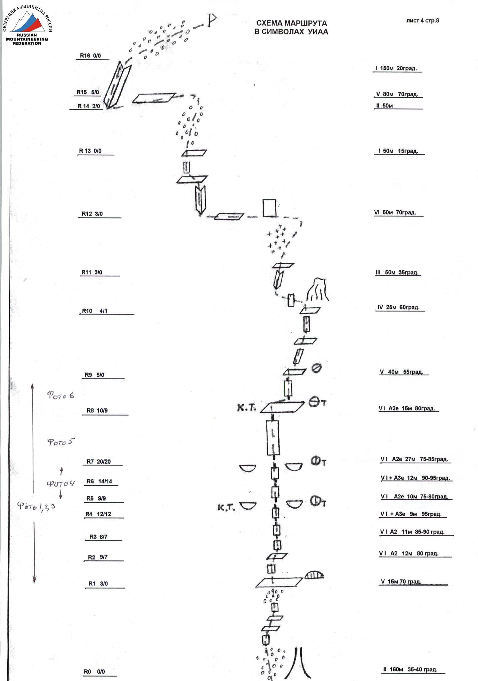
R0–R1. Left of the snow-ice couloir:
- ascend through scree upwards for 70 m;
- then 50 m along broken ledges;
- another 40 m through scree to a wide scree ledge.
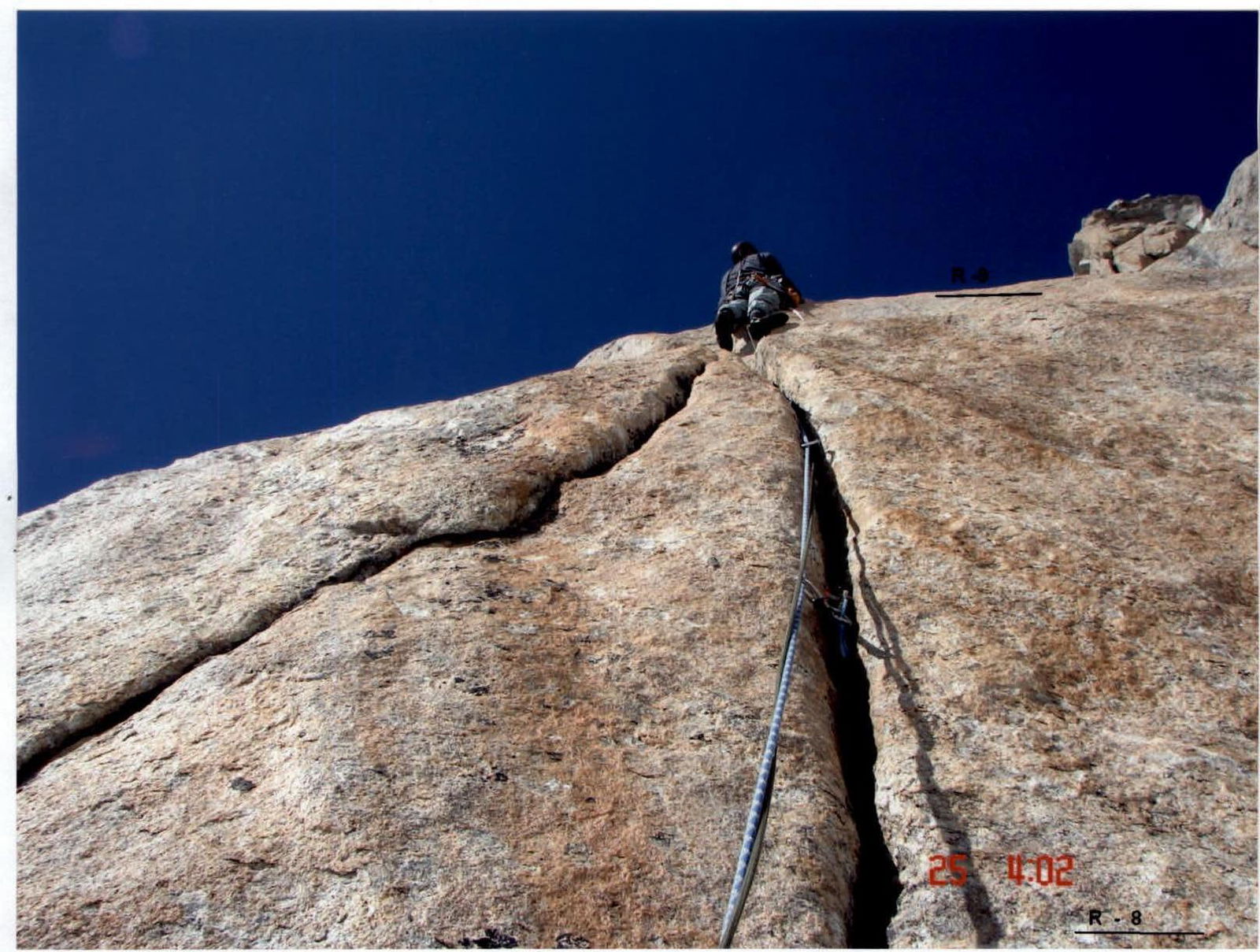
R1–R2. Beginning of the wall section of the route, characteristic niche 10 m to the left of Ryzhikov's Route (5A category of difficulty), straight up 15 m, 70°, 5th category of difficulty to a ledge. Station on bolts on the ledge.
R2–R3. From the ledge, 12 m, 80°, straight up through a crack using artificial aids, 6th category of difficulty.
R3–R4. The crack splits into two. Through the right crack, 11 m, 85–90°, 6th category of difficulty, artificial aids.
R4–R5. 8–9 m through an overhanging crack to a station, 95°, 6+, artificial aids, hanging belay.
R5–R6. 10 m along a slab with a crack, 75–80°, 6th category of difficulty, artificial aids.
R6–R7. Vertical crack, 12 m, 90–95°, 6th category of difficulty, artificial aids. Station on two bolts.
R7–R8. 27 m along a slab with a crack, 75–85°, 6th category of difficulty, artificial aids, exit to a balcony, hanging belay.
R8–R9. From the balcony, 14–15 m, 80°, 6th category of difficulty through a crack to a small ledge, artificial aids.
R9–R10. From the ledge, upwards and to the right through cracks and small walls, exit under an overhanging rock, 40 m, 5th category of difficulty.
R10–R11. From under the rock — a difficult traverse left for 3 m and then along an internal corner, bypassing a large boulder to the left to a snow ledge, 25 m, 4th category of difficulty, 60°.
R11–R12. Along the snow ledge, on the left side of a small ridge, and then along the ridge upwards and to the right to the wall, 50 m, 35°, 3rd category of difficulty. Here, the route joins Ryzhikov's Route.
R12–R13. Traverse left along the wall on a heavily destroyed ledge to an internal corner and ascend through it to a ledge, from it along a 5-meter wall to a snow ledge, 50 m, 70°, 4th category of difficulty.
R13–R14. Along a scree slope, 50 m in the direction of a rocky bastion, 15°, 1st category of difficulty.
R14–R15. Traverse left and down under the bastion to an internal corner, 50 m, 1st category of difficulty.
R15–R16. Ascend through the internal corner for 80 m to the pre-summit slope, 70°, 5th category of difficulty, the internal corner is filled with accrued ice.
R16–R17. Along the slope, exit to the first ridge and then along the ridge for 150 m to the summit.
Tactical Actions of the Team
On the R1–R0 section, the team decided to ascend to the left of the described route due to the state of the snow cover. They ascended "head-on" through scree and a destroyed rocky bastion.
The Key — an absolutely smooth wall with a single wide crack. The key section was divided in half — at the first station, they switched the lead climber, which is not very convenient on a hanging station, but both wanted to work. The second station was made after 25 m. It's indeed more convenient due to the large amount of equipment used. The first two stations were hanging.
Starting from R4, bolts were encountered every 4–5 m.
Most complex sections:
- R4–R5 — overhang;
- R6–R7 — overhang.
Most often, large and medium-sized cams were used. Due to their shortage, they had to descend and remove previous points several times after reaching the next bolt.
Belays were made through stationary stations using two ropes. Hookclips were used, which significantly simplified the process due to the large number of artificial points of support.
Recommendations
On the route, there are PETZL bolts; it's advisable to have 8–9 hangers.
- Large and medium-sized cams were used most often — recommend taking 6–7 pcs. A set of nuts will also be useful. Hooks were not used.
- Hookclips or belay devices are recommended for each climber — very convenient for the belayer.
- 18–19 quickdraws will be required for a rope team.
- The beginning of the route is easily found by a characteristic niche on a scree ledge 15 m from Ryzhikov's Route, and the single crack on the smooth wall is visible from afar.
Route Safety Assessment
The route is generally not rockfall-prone, except for the first section. It's better to ascend this section together. On the key section, rocks fly higher due to the overhang. After the key section, there are destroyed rocks with "live" stones.
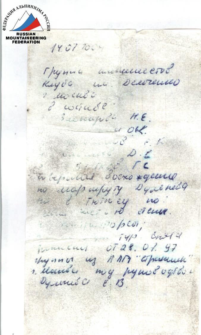 Note from a group of climbers from the Demchenko Club, July 14, 2004.
July 14, 2004.
A group of climbers from the Demchenko Club, Moscow, consisting of:
- Zolotareva N.E.;
- Kichigina O.K.;
- Mikhailov S.K.;
- Savelyev D.S.;
- Kochetkov G. Completed an ascent on Dulnev's Route to the Tyutyu 2nd Western peak via the left part of the South face of the South ridge. They passed the first control point.
Ukraine Youth and Sports Department of Dnipropetrovsk Regional State Administration Mountaineering and Rock Climbing Federation of Dnipropetrovsk Region 49000, Dnipropetrovsk, K. Marx Ave., 65. 8(0562)474166 e-mail: lenfleer@creator.dp.ua
At 17:30 on July 25, 2007, a group of climbers completed an ascent to the summit via the 2–3 West route along the South ridge (Khrustalik) (route) 3B category of difficulty.
Group members:
- Leader: Semenova;
- Participants: Poznyak A., Martynenko I., Drapak A., Pidniy A., Tkachenko V., Samarskiy A.
A note from A.D. Ryzhkov's group under the leadership of N.I. Motienko dated July 25, 2007, was retrieved.
Descent via the 2–3 route started at 17:36.
Weather: superb.
Leader's signature: A.D. Ryzhkov.
View of the route with marked sections.

Photo 1
Photo 2
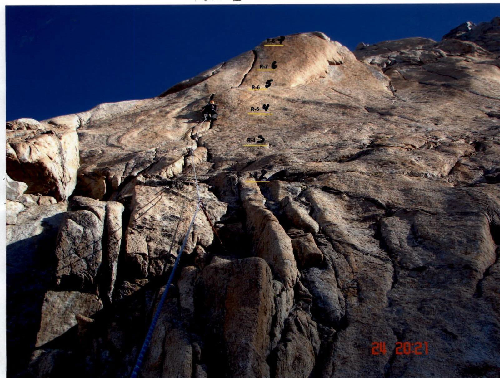
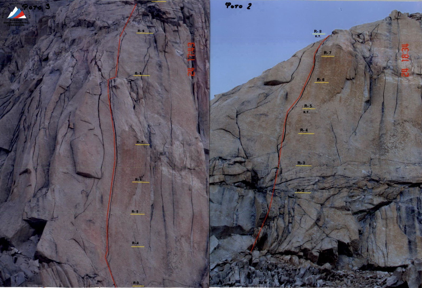
Photo 3
Photo 4
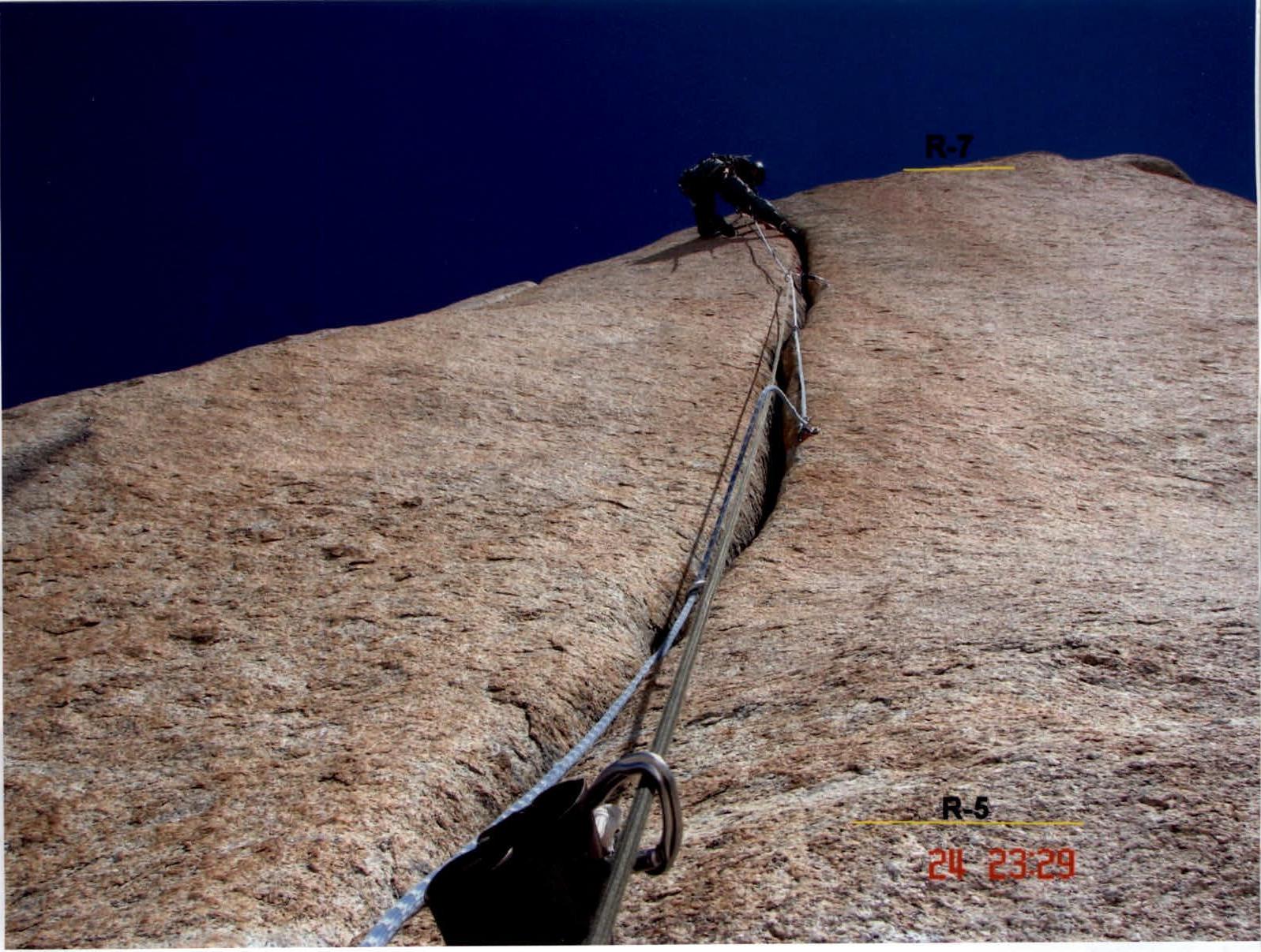
Photo 5
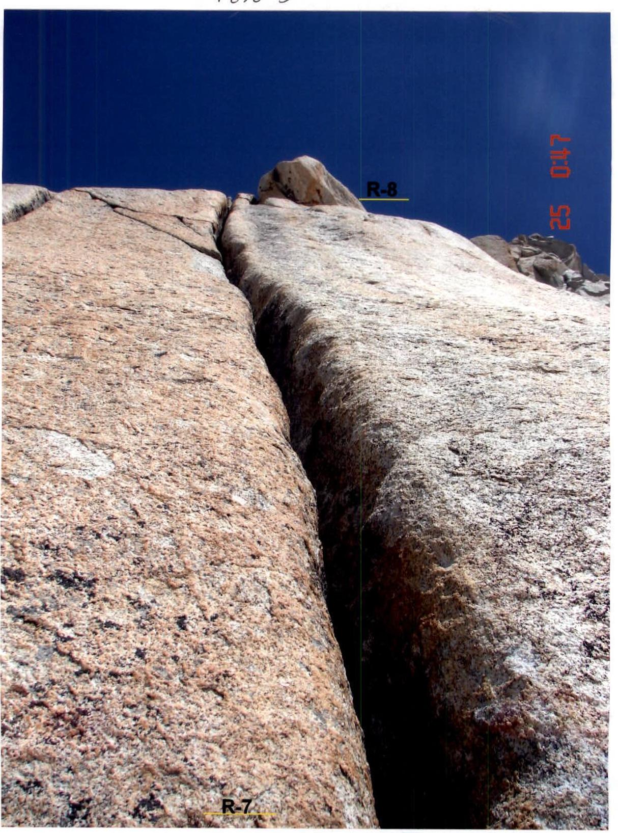
Photo 6
 View from the summit of Tyutyu 2nd Western. Control point.