Passport
- Technical category
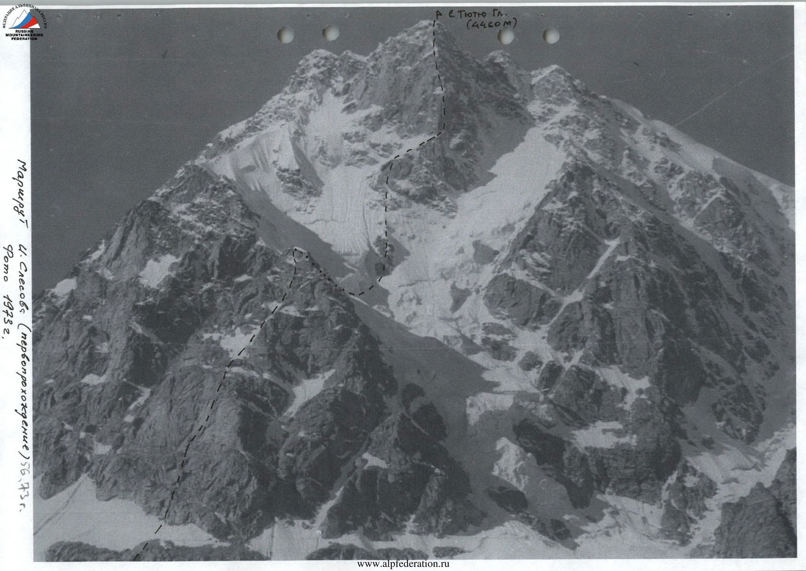
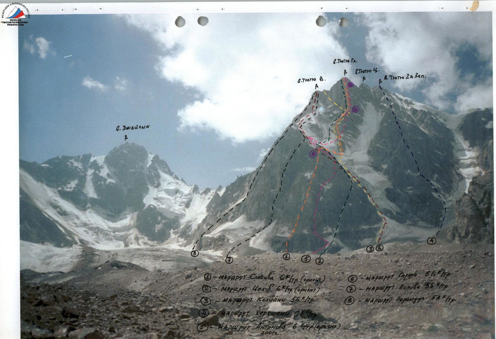
- Central Caucasus, Tютю Су gorge
- Mt. Тютю Glavnaya via North Ridge, 4460 m
- Category 6B (approximate), route by I. Slesov, third ascent
- Height difference — 1310 m, length — 1675 m.
Average steepness of the upper wall section — 77°. Average steepness of the lower section — 65°. Length of sections with category 5 difficulty — 670 m. Length of sections with category 6 difficulty — 540 m.
- Pitons driven:
| Type | Quantity |
|---|---|
| rock | 20 |
| bolt | 5 |
| chocks | 106 |
| ice screws | 27 |
- Time on route — 44 hours and 4 days
- Overnights:
- on the ridge before the first category difficulty (lying down)
- on a platform under the second bastion (lying down)
- on the North Ridge under the summit (sitting)
- Team leader — Antonov Sergey Ivanovich — Candidate Master of Sports
Team members:
- Yatsenko Petr Nikolaevich — Candidate Master of Sports
- Borshchev Mikhail Valentinovich — Candidate Master of Sports
- Coach Zaitsev Kim Kirillovich, Master of Sports, instructor 1st category
- Departure to the route: August 2, 2001
Summit: August 5, 2001
Return: August 5, 2001
Team leader Antonov Sergey Ivanovich
105077, Moscow E-77, ul. Pervomayskaya, 97, apt. 24, tel. 465-60-32 (home), 269-40-87 (work)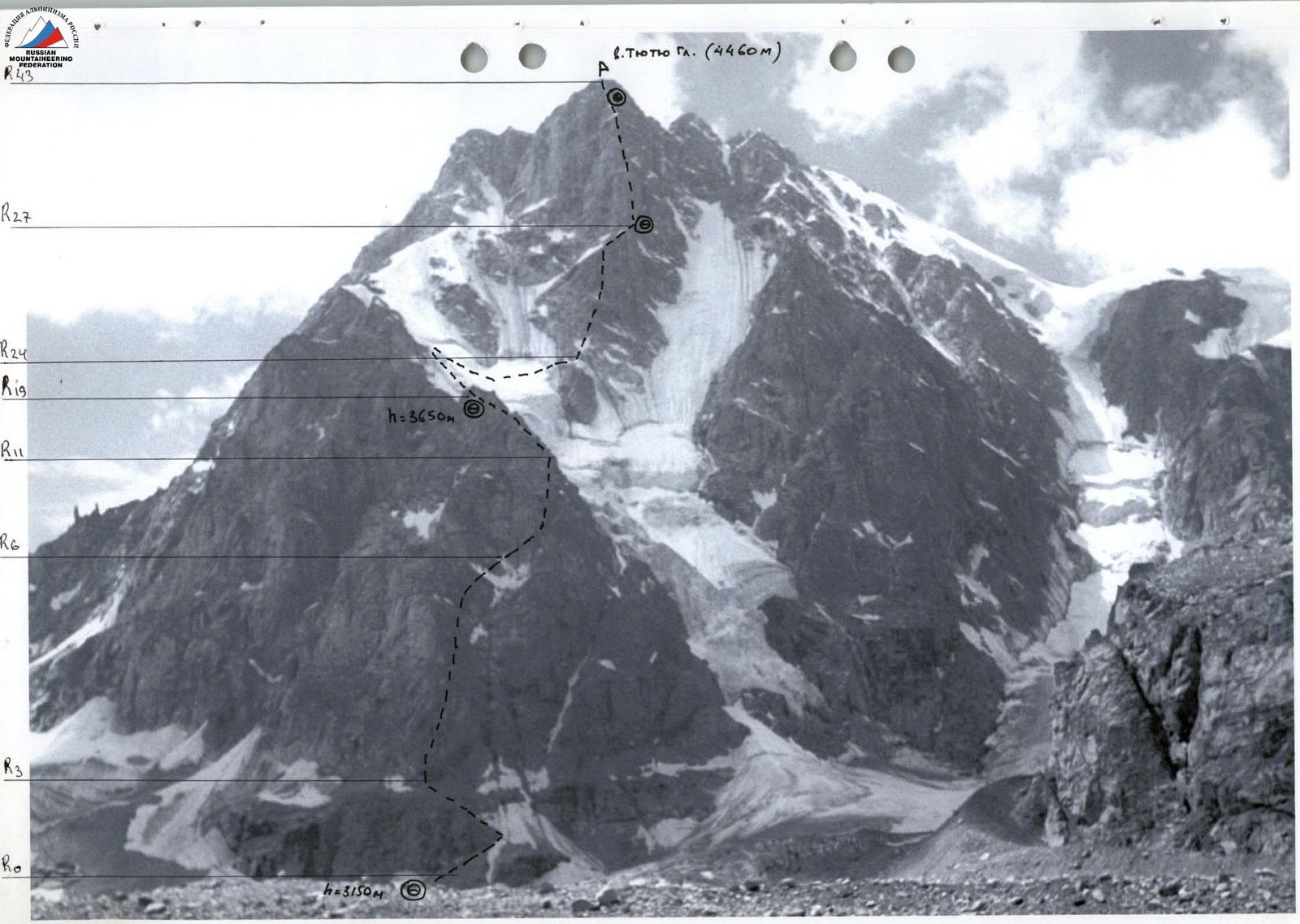
Passage to the first bastion, sections R20–R26
Route profile on the right
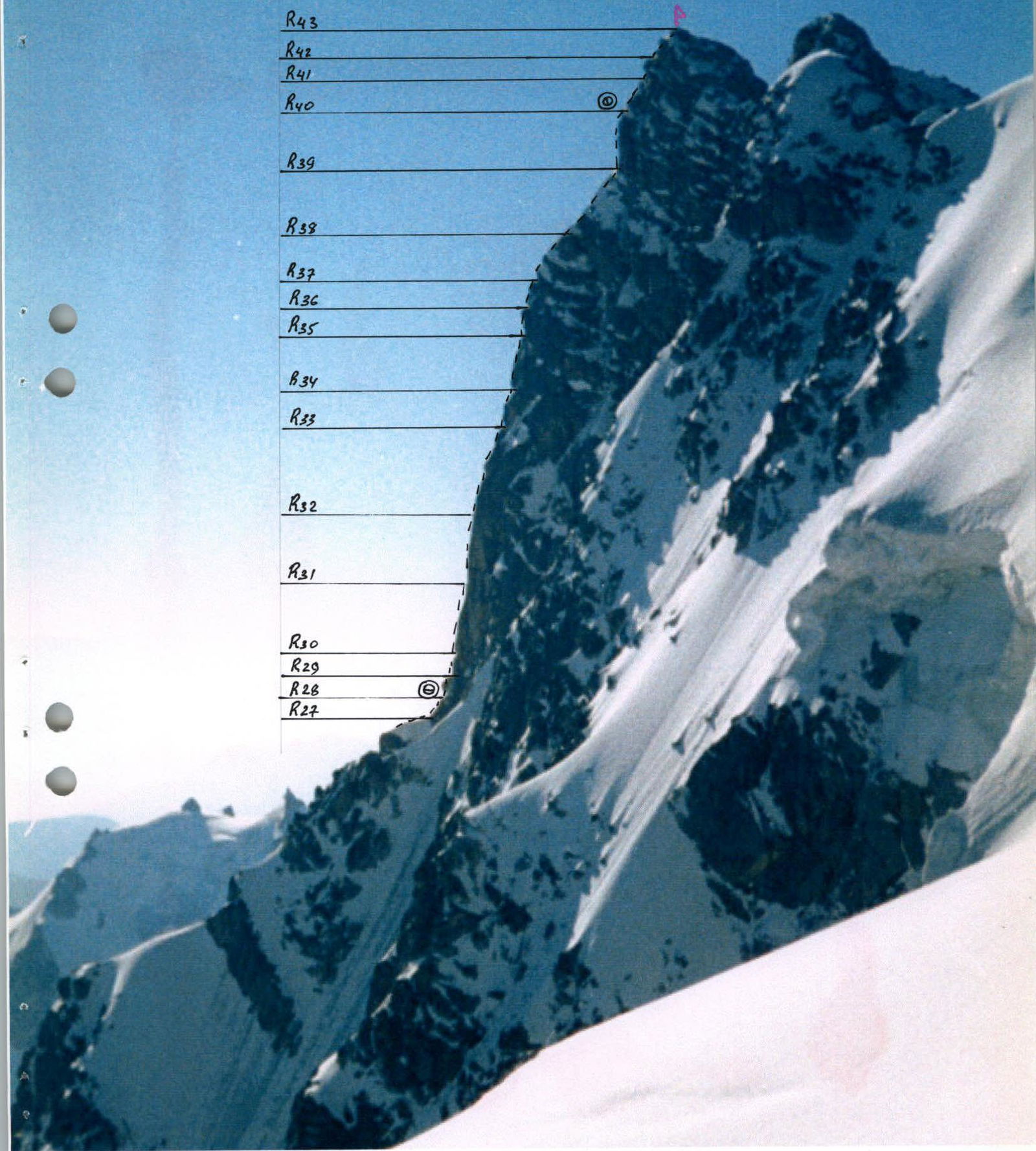
Tactical actions of the team
On July 31, 2001, the team departed from ULSB "Ullu-Tau" to Tютю Su gorge. Approach to the route through the gorge. Set up camp at 18:00.
On August 1, 2001, at 10:00, they reached the campsite under the route on the moraine of Tютю glacier under the North wall. The rest of the day was spent observing the route and the rockfall regime in the ice couloir, which had to be crossed to reach the key point of the route.
There was one rope team: Borshchev M.V. — Antonov S.I. — Yatsenko P.N. Team members were equal, and the first numbers were constantly changing. On particularly difficult sections, the first climber was relieved of their backpack and set up a rope protection; the backpacks were then pulled up. On August 2, 2001, at 6:00 AM, they departed from the campsite under the route.
The weather was unstable, so they tried not to linger on the route, moving relatively quickly without compromising safety. They stopped for the night at 19:00.
The passage across the hanging glacier was complex due to numerous crevasses and bergschrunds. There was a high risk of rockfall and ice avalanches.
From the campsite under the triangle, they had to climb four ropes of ice with a steepness of 50°, bypass the bergschrund, and traverse the icy slope of the hanging glacier to the top of the rocky island under the lower bastion of the North ridge. This had to be done early in the morning, as rocks started falling from above later in the day. The team successfully accomplished this task. On August 3, 2001, at 2:00 AM, they departed from the campsite on the ridge. The weather was good, with a moon. At 6:00 AM, they reached a ledge in the upper part of the rocky island, at the lower part of the first bastion. By 12:00, they reached a ledge under the second bastion, set up a bivouac, and began processing the second rocky bastion. They fixed three ropes. At 21:00, they stopped for the night. On August 4, 2001, at 7:00 AM, they continued on the route from the campsite. The weather was satisfactory.
On the route, they used chocks, rock and ice pitons, and old bolt pitons left by the first ascensionists.
They stopped for the night after passing the overhanging wall on a narrow ledge. Conditions:
- Weather — dense fog.
- Overnight — sitting.
On August 5, 2001, at 7:00 AM, they continued on the route.
- At 10:00, they reached the summit of Тютю Glavnaya.
- Descent from the summit began at 11:00 via the East ridge through Тютю Vostochnaya summit, following a category 2B route.
The weather was unstable. At times during the route:
- it rained,
- there was fog,
- a thunderstorm passed.
They had sufficient food, equipment, and safety margin to complete the ascent.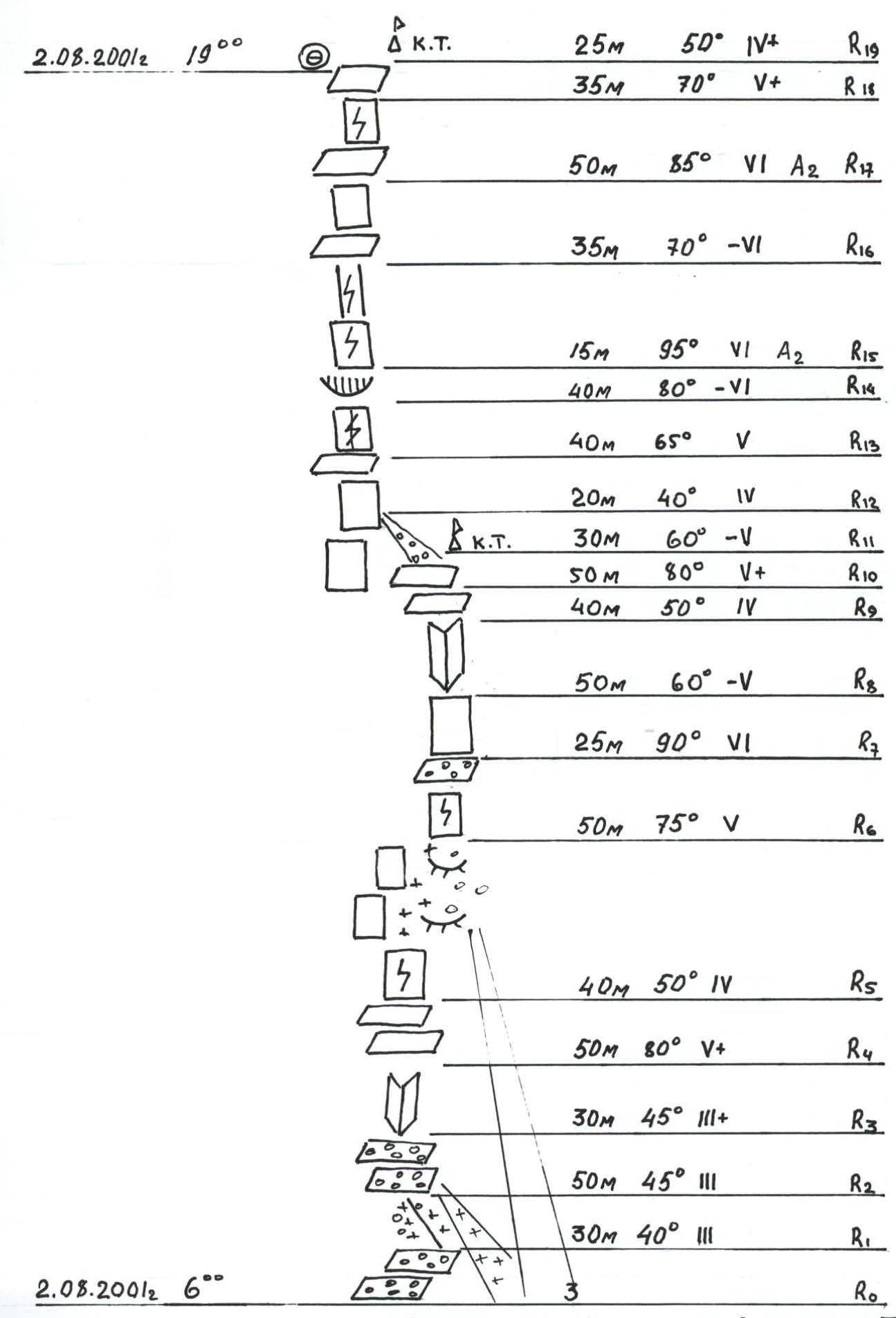
UIAA scheme for Mt. Тютю Glavnaya via North Ridge of the North wall, category 6B (approximate) (sections R0–R19)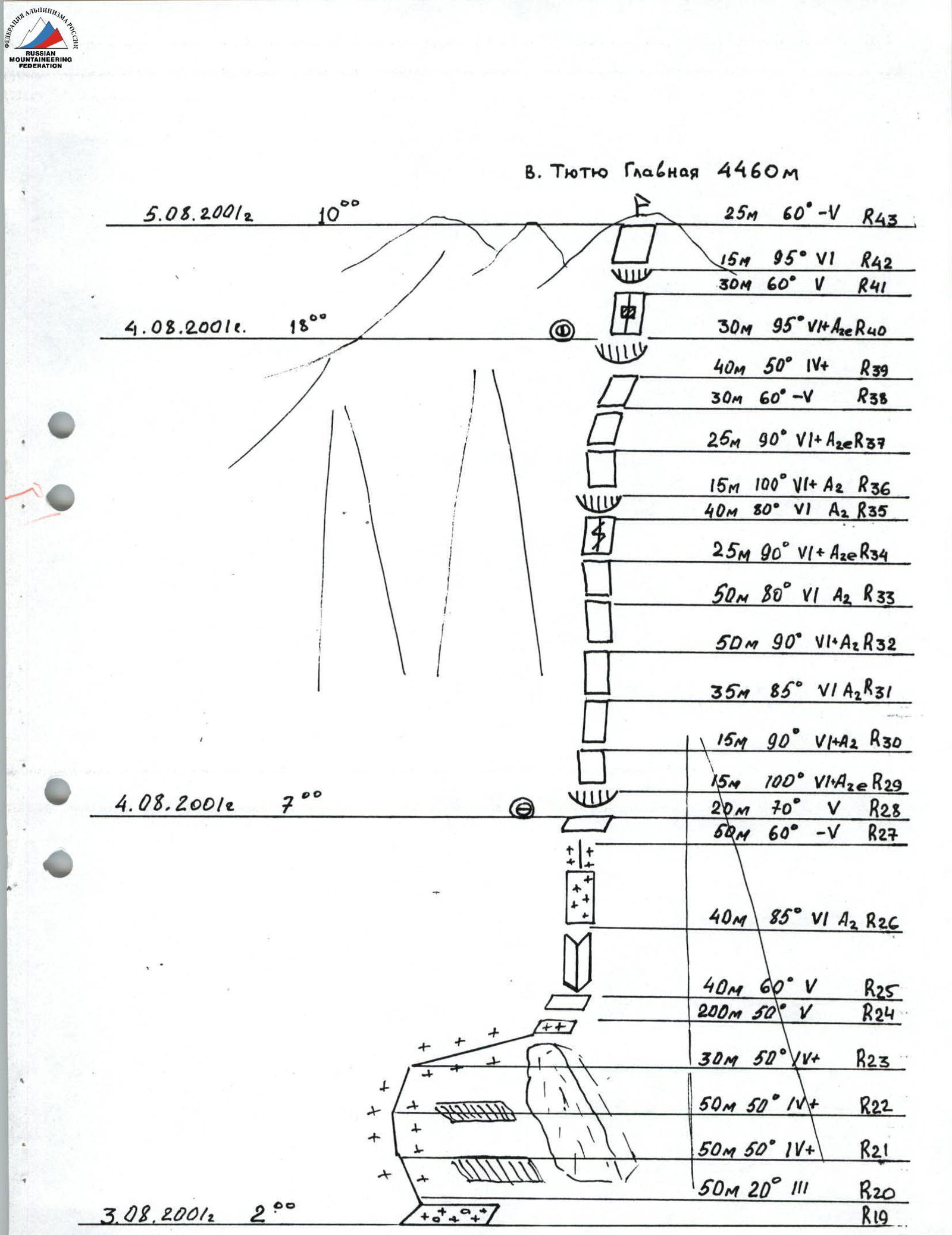
UIAA scheme for Mt. Тютю Glavnaya via North Ridge of the North wall, category 6B (approximate) (sections R19–R43)
Brief description of the route
Section R0–R1 — along scree ledges to the right to a snowy couloir.
Section R1–R2 — through the left part of the snowy couloir, with ice in the upper part, to a scree ledge.
Section R2–R3 — along scree ledges under the wall. Left along the ledge for 10 m to a vertical inner corner.
Section R3–R4 — climb the inner corner using free climbing. In the upper part of the corner, there is a 5-meter vertical wall with small holds. Protection: cams and chocks are used; backpacks are pulled up.
Section R4–R5 — exit to a ledge. Along the ledge, traverse right for 40 m to a wet couloir under a 10-meter wall.
Section R5–R6 — the wall is climbed using free climbing, then along steep snow (10 m) under the wall and along the snow boundary, traverse right and up under the wall (protection: chocks).
Section R6–R7 — a 25-meter vertical wall is climbed using free climbing (protection: chocks, cams) to a ledge.
Section R7–R8 — from the ledge, left and up along large rocky blocks to a large inner corner.
Section R8–R9 — climb the right part of the inner corner.
Section R9–R10 — a steep slab is climbed using free climbing, then exit to a ledge (protection: pitons, chocks).
Section R10–R11 — a diagonal ledge left and up (loose rocks) to a ridge. There is a good bivouac site (control cairn).
Section R11–R12 — up and left along a scree couloir to a ledge.
Section R12–R13 — from the ledge, straight up the wall to a narrow platform (for two people only) (protection: chocks and cams).
Section R13–R14 — from the platform, right for 8 m under the wall and up the wall along a crack under a cornice (protection: chocks, cams).
Section R14–R15 — the cornice is traversed on ladders along the left part through a crack (large chocks and cams).
Section R15–R16 — a 15-meter section turning into a chimney is climbed using free climbing (rock pitons, chocks) to a narrow ledge.
Section R16–R17 — a vertical smooth wall is climbed along the right part (rock pitons, ladders).
Section R17–R19:
- along a narrow ledge left and up,
- a 15-meter wall straight up using free climbing,
- then along a diagonal ledge left and up to a platform on the ridge.
A good site for a tent. (Control cairn — a can on a piton) (protection: chocks and cams). Overnight stay.
Section R19–R20 — from the bivouac site along a horizontal ledge to an icy slope.
Section R20–R23 — along ice up and right for 3 ropes under the rocks (ice screws).
Section R23–20 — through rocky outcrops, descent down for 30 m to a snow pad and then transition to the hanging glacier (caution: crevasses!). Along the glacier for 150 m, traverse up and right to the bergschrund. Cross the bergschrund, climb 15 m, and exit to the upper part of the rocky island, to a snowy ledge. (Caution! Rockfall possible.)
Section R24–R25 — along rocks for 40 m to a vertical inner corner (protection: chocks).
Section R25–R26 — through the inner corner (ladders) to a diagonal ledge covered with ice and snow.
Section R26–R28 — along the diagonal ledge up and right to a snowy-icy nose and along it left and up to a ledge under a cornice. Site for a tent. Overnight stay.
Section R28–R29 — the cornice is traversed on the left (bolt pitons, ladders, cams).
Section R29–R30 — a vertical wall with few holds (bolt pitons, ladders).
Section R30–R33 — a vertical wall (ladders, bolt pitons left by previous ascensionists, cams).
Section R33–R34 — a smooth vertical wall. Two bolt pitons driven (ladders, cams).
Section R34–R35 — a vertical wall with a crack, old bolt pitons left by previous ascensionists; passage under a cornice (ladders).
Section R35–R36 — the cornice is traversed through a crack (cams, old bolt pitons, ladders).
Section R36–R37 — a smooth vertical slab for 25 m (bolt piton, cams, ladders).
Section R37–R39 — along inclined slabs under an overhanging 30-meter wall (chocks, rock pitons, cams).
Section R39–R40 — the overhanging wall is climbed along the left part. Two bolt pitons driven; cams, rock pitons, and ladders used. Narrow ledge. Sitting overnight stay.
Section R40–R41 — an inclined wall with a crack, some ice (ice screws, ladders, cams).
Section R41–R42 — the cornice is traversed on the right (cams, chocks, ladders).
Section R42–R43 — climb to the summit of Тютю Glavnaya along a slab and destroyed rocks.
Descent via the East ridge through Тютю Vostochnaya summit along a category 2B route to Zapadny Tютю glacier.
| Date | Section | Average steepness | Length (m) | Terrain characteristics | Difficulty category | Route condition | Weather conditions | Rock pitons (persons) | Ice screws (persons) | Chocks (persons) | Bolt pitons (persons) | Movement pattern | Departure time |
|---|---|---|---|---|---|---|---|---|---|---|---|---|---|
| R0–R1 | 40° | 30 | scree ledge | 3 | scree | sun | - | - | - | - | simultaneously | 8:00 | |
| R1–R2 | 45° | 50 | couloir | 3 | dense snow, ice in upper part | sun | - | 1 | - | - | simultaneously | ||
| R2–R3 | 45° | 30 | rocky scree ledges | 3 | fine scree | sun | - | - | - | - | alternately | ||
| R3–R4 | 80° | 50 | rocky inner corner | 5 | monolithic rocks | sun | - | - | 4 | - | via rope protection | ||
| R4–R5 | 50° | 40 | wide long ledge | 4 | destroyed rocks | sun | - | - | 1 | - | simultaneously | ||
| R5–R6 | 75° | 50 | rocky wall, snowy slope, "ram's forehead" | 5 | rocks with snow, dense snow and ice | sun | - | 1 | 3 | - | alternately | ||
| R6–R7 | 90° | 25 | vertical rocky wall | 6 | wet wall with longitudinal cracks | sun | 1 | - | 2 | - | via rope protection | ||
| R7–R8 | 60° | 50 | large rocky blocks | 5 | large-block destroyed rocks | cloudy | - | - | 4 | - | alternately | ||
| R8–R9 | 50° | 40 | rocky inner corner | 4 | destroyed rocks | cloudy | - | - | 4 | - | alternately | ||
| R9–R10 | 80° | 50 | vertical rocky wall | 5 | destroyed rocks | cloudy | 1 | - | 5 | - | alternately | ||
| R10–R11 | 60° | 30 | rocky scree ledges | 5 | destroyed rocks | cloudy | - | - | 3 | - | alternately | ||
| R11–R12 | 40° | 20 | scree couloir | 4 | scree with ice | cloudy | - | - | - | - | alternately | ||
| R12–R13 | 65° | 40 | rocky wall | 5 | destroyed rocks | cloudy | 1 | - | 4 | - | alternately | ||
| R13–R14 | 80° | 40 | rocky wall | 6 | destroyed rocks | cloudy | - | - | 5 | - | via rope protection | ||
| R14–R15 | 95° | 15 | rocky cornice | 6 | monolithic rocks | cloudy | 1 | - | 4 | - | via rope protection | ||
| R15–R16 | 70° | 30 | rocky wall, chimney | 6 | monolithic rocks | cloudy | 1 | - | 4 | - | alternately | ||
| R16–R17 | 85° | 50 | rocky wall | 6 | monolithic rocks | cloudy | 2 | - | 5 | - | via rope protection | ||
| R17–R18 | 70° | 35 | rocky wall | 6 | destroyed rocks | snow, sleet | 1 | - | 4 | - | via rope protection | ||
| R18–R19 | 50° | 25 | rocky scree ledges | 4 | destroyed rocks | cloudy, thunderstorm | - | - | 3 | - | alternately | ||
| August 3, 2001 | R19–R20 | 20° | 50 | scree ledge with snow | 3 | destroyed rocks | frosty, moonlight | - | - | - | - | simultaneously | 2:00 |
| R20–R23 | 50° | 130 | ice | 4 | ice covered with snow | frosty, moonlight | - | 15 | - | - | alternately | ||
| R23–R24 | 50° | 200 | ice | 5 | ice, hanging glacier, bergschrund | frosty, moonlight | - | 9 | - | - | via rope protection | 7:00 | |
| R24–R25 | 60° | 40 | rocky slabs | 5 | slabs with rime ice | sun | 1 | - | 4 | - | alternately | ||
| R25–R26 | 85° | 40 | rocky inner corner | 6 | inner corner with rime ice | sun | 1 | - | 5 | - | via rope protection | ||
| R26–R27 | 60° | 50 | snow with ice and rock outcrops | 5 | diagonal ledge with snow and ice | sun | - | 3 | - | - | alternately | ||
| R27–R28 | 70° | 20 | rocky wall | 5 | destroyed rocks | sun | - | - | 3 | - | alternately | 11:00 | |
| August 4, 2001 | R28–R29 | 100° | 15 | rocky cornice | 6 | monolithic rocks | sun | 1 | - | 3 | 3 | via rope protection | 7:00 |
| R29–R30 | 90° | 15 | rocky wall | 6 | monolithic rocks | sun | - | - | 3 | 2 | via rope protection | ||
| R30–R31 | 85° | 35 | rocky wall | 6 | monolithic rocks | sun | - | - | 3 | 5 | via rope protection | ||
| R31–R32 | 90° | 50 | rocky wall | 6 | monolithic rocks | sun | 1 | - | 5 | 4 | via rope protection | ||
| R32–R33 | 80° | 50 | rocky wall | 6 | monolithic rocks | sun | 2 | - | 5 | 2 | via rope protection | ||
| R33–R34 | 90° | 25 | rocky wall | 6 | smooth wall | sun | 1 | - | 4 | 2 | via rope protection | ||
| R34–R35 | 80° | 40 | rocky wall | 6 | monolithic rocks, crack | sun | 1 | - | 5 | 2 | via rope protection | ||
| R35–R36 | 100° | 15 | rocky cornice | 6 | monolithic rocks, crack | cloudy | - | - | 5 | 3 | via rope protection | ||
| R36–R37 | 90° | 25 | rocky wall | 6 | monolithic rocks | cloudy | - | - | 5 | 1 | via rope protection | ||
| R37–R38 | 60° | 30 | inclined slab | 5 | monolithic rocks | cloudy | - | - | 5 | - | via rope protection | ||
| R38–R39 | 50° | 40 | inclined slab | 5 | monolithic rocks | cloudy | - | - | 5 | - | alternately | ||
| R39–R40 | 95° | 30 | overhanging wall | 6 | monolithic rocks | cloudy, fog | 2 | - | 5 | 2 | via rope protection | 18:00 | |
| August 5, 2001 | R40–R41 | 60° | 30 | rocky wall | 5 | destroyed rocks with ice | sun | 2 | - | 4 | - | via rope protection | 7:00 |
| R41–R42 | 95° | 15 | rocky cornice | 6 | monolithic rocks, crack | sun | - | - | 4 | - | via rope protection | ||
| R42–R43 | 60° | 25 | inclined slab | 5 | slab, destroyed rocks | sun | - | - | 4 | - | alternately | 10:00 |