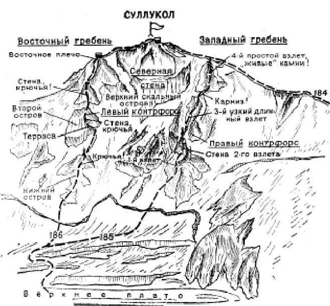
- Sullukol via Western Ridge (Category 1B route). From the Adylsu alpine camp, follow the Baksan Valley highway downhill. Below the Eljurt village, cross the Baksan River via a bridge, then turn right and, after 1.5-2 km uphill along the right (orographic) bank of Baksan, reach the ruined settlement of Tyutyu, at the confluence of the Tyutyusu River and Baksan. Cross the Tyutyusu River and, turning left, ascend via a steep trail on the right bank of Tyutyusu. Beyond the canyon, the trail gradually descends to the Tyutyusu River, crosses via a bridge to its forested, cliffy left bank, and follows along it. The trail alternates between approaching the river and diverting into side gullies, passing through copses of shrubs, two lateral terminal moraines, and intersecting a small stream flowing from the Adzhikol slopes. Beyond the last grove, the trail disappears. Ascend the grassy slopes of the Tyutyusu left bank valley. The initial ascent in the valley is better approached from the left via a grassy slope of the Adzhikol peak. Beyond this ascent, follow the sandy valley of the Tyutyusu left bank to the stream flowing from the Zapadny Karyarta glacier, which descends via two waterfalls from a high-lying left lateral gorge. Ford the Zapadny Karyarta stream and ascend the Tyutyusu gorge to the second steep ascent in the Tyutyusu valley. Several streams flow from this ascent: from the left, from the Severny Tyutyusu glacier, and to the right of a massive rock rising in the center of the ascent, from the Severny Sullukol glacier. Here, cross to the right bank of Tyutyusu and, to the right of the massive rock, ascend the steep slopes of the ascent along the Sullukol stream, which flows into the Tyutyusu, to reach the Severny Sullukol glacier. Traverse the glacier uphill to the right, then ascend a snowy slope to the right towards the foot of the col on the Severny spur, branching off from beneath the northern slope of Sullukol's Western Ridge, near the point where a small waterfall drops from it. From the glacier, ascend simple, heavily fragmented rocks to the col, from which a waterfall flows. The initial bivouac is on the col's flat areas. From the col, turn left and ascend a gradually steepening snowy slope (hidden crevasses!), then simple, fragmented, possibly completely snow-covered rocks, to reach the 30th Anniversary of Soviet Alpinism pass on Sullukol's Western Ridge. From the pass, turn left and traverse initially along the left, then the right side of the scree-covered, snow-capped Western Ridge. Further, ascend a steep icy slope (belay required!), which gradually becomes less steep and transitions into a snowy slope, to reach the summit plateau. The journey from the pass takes 1.5-2 hours. From the plateau, ascend simple, partially moderately difficult rocks on the right side of the ridge to the Sullukol summit. The ascent from the bivouac takes 6-8 hours. Descend via the ascent route. The total duration of the route is 3 days. Additionally, bring 2-3 ice axes and crampons for all participants.