Ascent Passport
I. Technical category 2. Central Caucasus, Adyr-Su, Kulumkol valleys 3. Jailyk peak via the right edge of the 1st Southern bastion of the Western ridge, 4533 m 4. Proposed — 5B cat. diff., first ascent 5. Height difference: 730 m, length — 1015 m. Length of sections with 5–6 cat. diff. — 240 m. Average steepness of the wall section of the route — 79° (3850–4100 m), including 6 cat. diff. — 75–95° (3905–4050 m) 6. Pitons hammered:
- rock: 53 (hammered) / 50 (left)
- bolt: 12 / 4
- chocks: 85 / 70
- ice screws: 2 / 0
- Team's climbing hours (excluding descent) — 26. Days — 4.
- Overnight stays on the route: one — in a tent on a rock shelf (semi-reclining)
- Team leader — Ivanov Alexander Vasilyevich, CMS
Participants:
- Melnik Vladimir Grigoryevich, CMS
- Ilyushchenko Alexey Valentinovich, CMS
- Azizbekyan Grigory Vartanovich, CMS
- Coach — Popov Viktor Pavlovich, MS USSR
- Approach to the route: August 14, 1987. Summit: August 17, 1987, return: August 18, 1987.
- AGLK "Jailyk", CS FIS
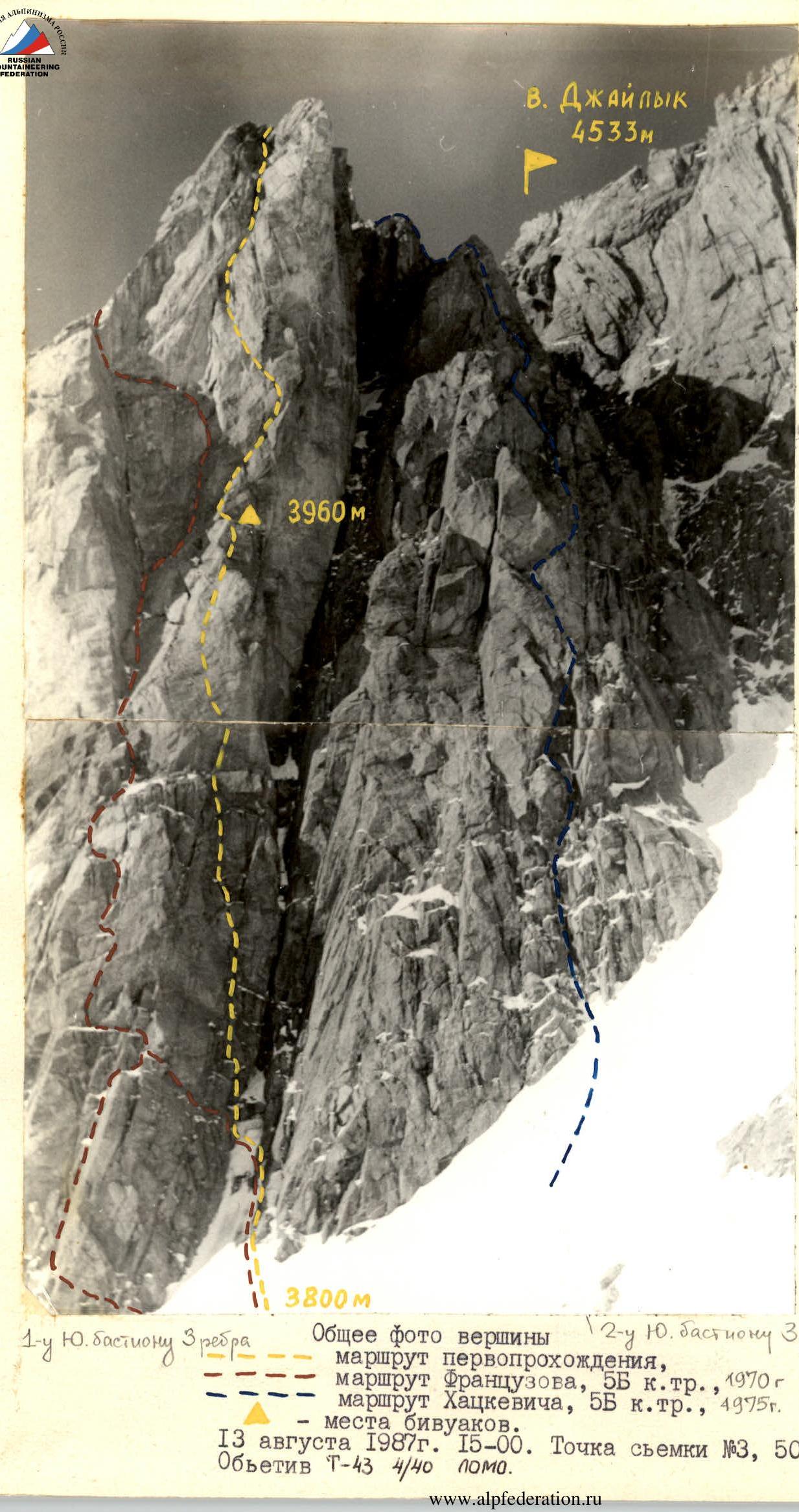
General photo of the summit of the 12th Southern bastion of the Western ridge:
— first ascent route
— Frantsuzov's route, 5B cat. diff., 1970
— Khatskevich's route, 5B cat. diff., 4975 m.
— bivouac locations.
August 13, 1987 15:00. Shooting point #3, 500 m, 3800 m. Lens T-43 4/40 LOMO.
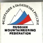
Wall profile on the right
First ascent route, bivouac location.
July 16, 1985 12:00. Shooting point #2, 500 m, 3950 m. Lens T-43 4/40 LOMO.

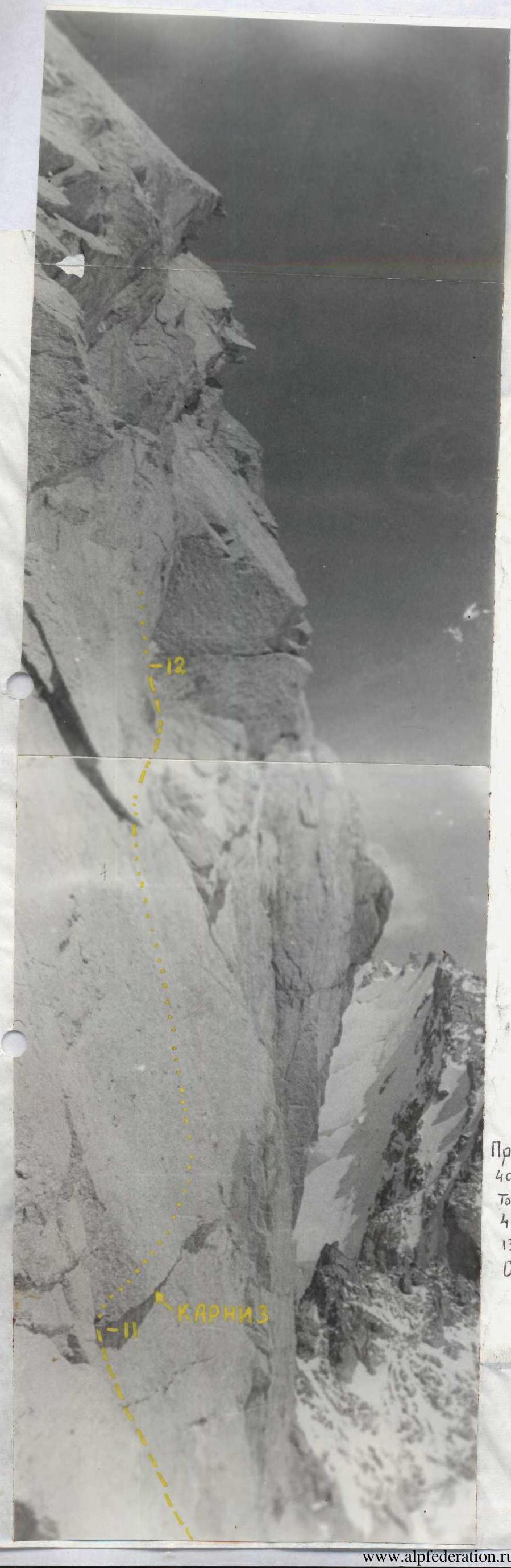
Semi-profile of the wall on the left — first ascent route, bivouac location.
July 16, 1985, 11:00, shooting point #1, 2 km, 3500 m. Lens T-43 4/40 LOMO.
Profile of the wall section of the route on Jailyk peak (4533 m)
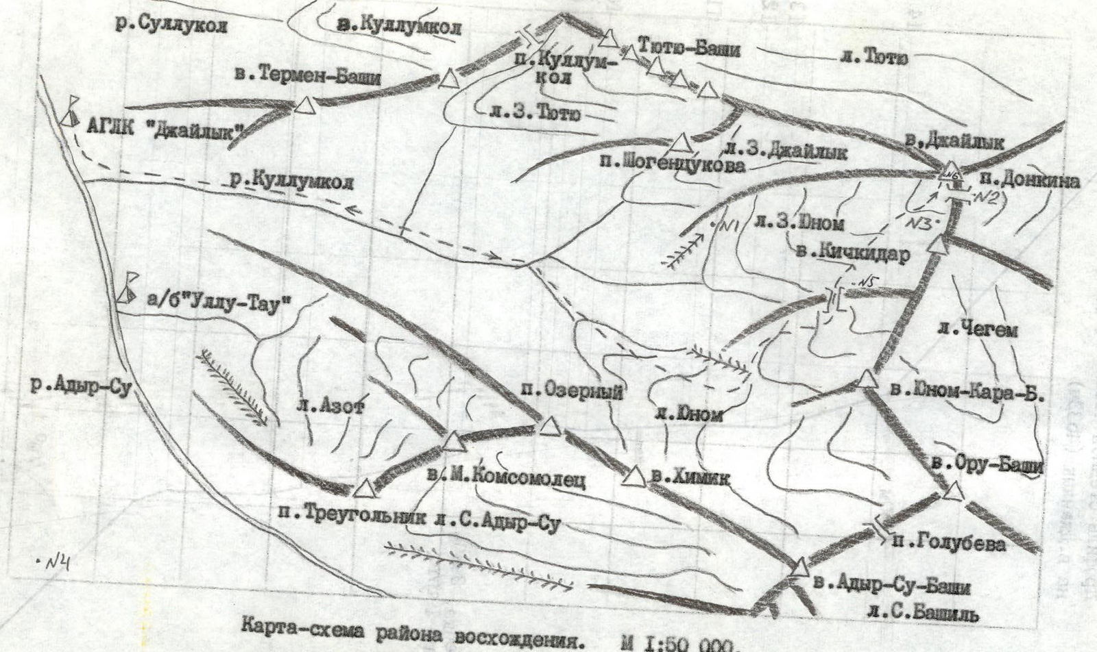
Map-scheme of the ascent area. Scale 1:50 000. — group's route.
Preparation for the ascent
Preparation for the first ascent on Jailyk peak via the right edge of the 1st Southern bastion began back in 1985, when a thorough study of the wall and its photography from various angles was conducted.
In the pre-competitive period (winter), candidates for the national team trained according to individual plans at their sports organizations. In the mountains, before heading out to the planned route, candidates for the team typically worked one shift with members of the alpine base, completing several ascents of 2–3 cat. diff. as part of training and sports groups.
Special training sessions were also conducted on:
- rock climbing;
- ice climbing.
Given the specifics of the upcoming route, rock climbing training focused on:
- practicing techniques for overcoming steep rock sections using artificial holds;
- ensuring safety while moving on hanging ropes.
At the alpine base's training ground, sessions were held to practice belaying techniques in complex emergency situations.
All candidates were tested on their technical and physical preparedness. Before heading out on the route, the team candidates completed a joint ascent of 4B cat. diff. to Stal peak. Based on the results of control tests and the training ascent, the final team composition was selected.
Ascent schedule

Profile on the left of the upper part of the wall. Shooting point #6, 150 m, 4000 m. August 13, 1987 14:00. Lens.
Team's tactical actions
The tactical plan for the ascent provided for (see route sheet):
- August 13 — approach to the route, processing the lower part of the route.
- August 14 — start on the route, climbing the first 100 m of the wall, and ascending the entire group to an overnight stay at point 6 according to the revised UIAA scheme (see sheet 8a).
- August 15 — ascend to the top of the 1st Southern bastion, overnight stay on the ridge.
- August 16 — reach the summit, descend to overnight stays under the route, return to the alpine base.
- August 17 and 18 — reserve days in case of bad weather.
Team's actions
The approach to the route was carried out in exact accordance with the tactical plan. Due to bad weather (snow, fog), the group was unable to conduct preliminary route processing.
On August 14, the pair Ilyushchenko (sect. R1–R5) — Azizbekyan (sect. R5–R6) processed 100 m of the route in 10 hours up to the planned overnight stay. By evening, the weather worsened again. A thunderstorm was approaching. For safety reasons, it was decided not to have the group ascend to the overnight stay on the wall. The pair descended to an overnight stay under the wall.
August 15 — snowfall, thunderstorm. Up to 35 cm of snow fell (see photos 12, 13). The group did not ascend.
August 16 — sunny weather. However, the wall remained covered in snow for a long time. At 14:00, when the wall's condition became satisfactory for further work, the group ascended in full composition via the hung ropes to the planned overnight stay (see photos 1–5). By 16:00, the group gathered on a shelf, organized a bivouac. At 17:00, the Melnik — Ivanov rope (Melnik worked first) began processing the route above the overnight stay. In 3 hours, they processed ~30 m (sect. R6–R8) (see photo 6).
August 17 — from 8:00, work on the wall continued. The Melnik (sect. R6–R10) — Ivanov (sect. R10–R14) rope worked first (see photos 7, 8, 10, 11). In 7 hours, the group reached the top of the bastion. Due to the weather deteriorating again and having 2 hours of daylight in reserve compared to the tactical plan, the group:
- abandoned the overnight stay on the bastion (overnight stays on Jailyk peak during thunderstorms are extremely dangerous);
- began moving towards the summit. At 17:30, the group reached the summit and began descending via the backup variant (as it was faster) through "Monakh". At 21:00, the group descended to overnight stays under the route, where they spent the night.
August 18 — the group returned to the alpine base by 12:45.
The first on sections R1–R14 worked on a double rope, one of which was imported, and used domestically produced shock absorbers.
On these sections, plus sect. R5–R6, ropes were organized. Movement on ropes was carried out with upper belay whenever possible.
Deviations from the tactical plan, resulting in a later ascent of the entire group to the planned overnight stay and an evening ascent to the summit, were associated with sharply deteriorating weather conditions (thunderstorms, snowfalls).
There were no falls or injuries. There were no disruptions to the radio communication schedule. From the summit, a note was retrieved from a group of instructors from the "Ullu-Tau" alpine base led by Galagan A.G. dated August 16, 1987.
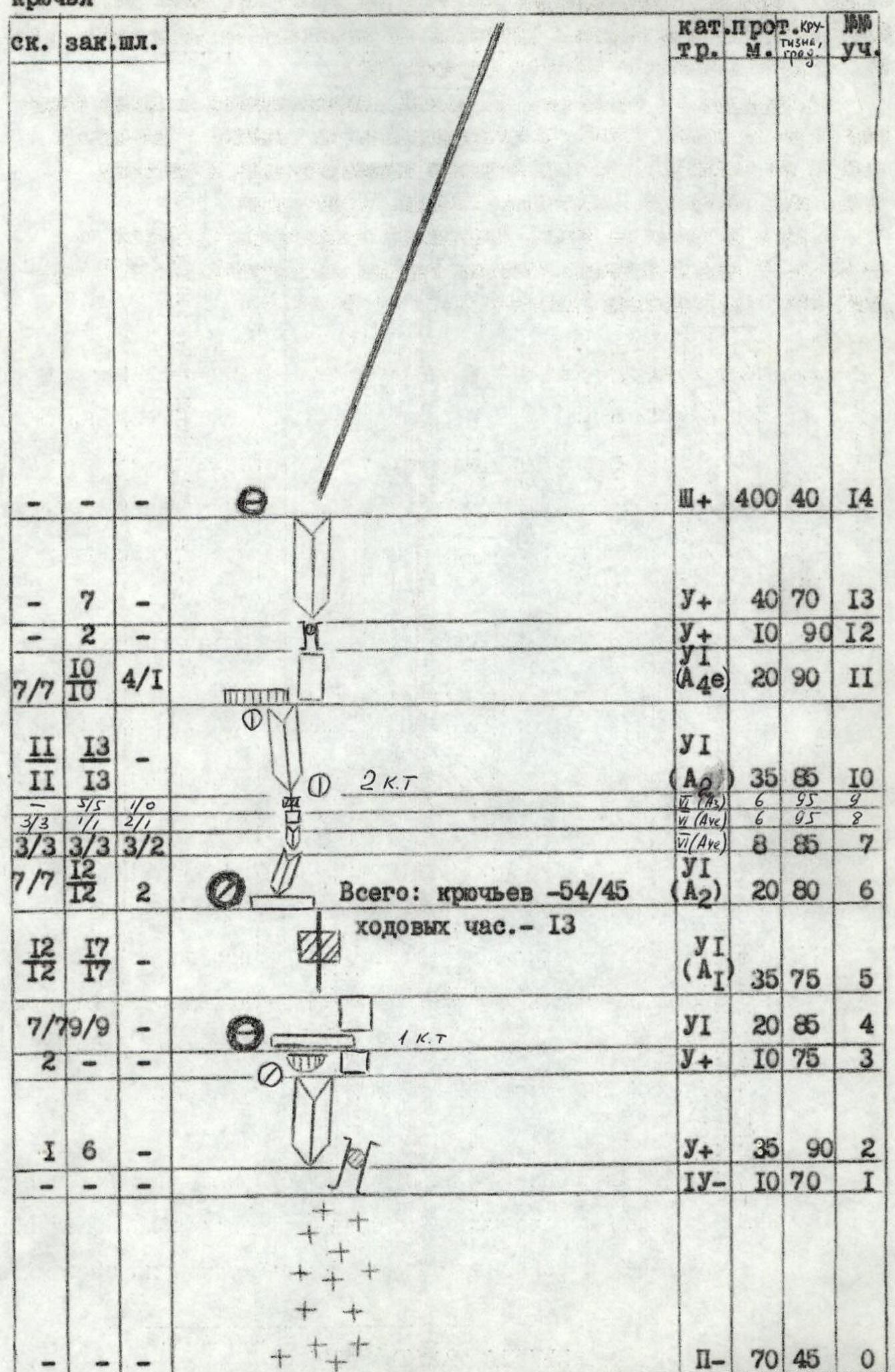
General data on route sections (up to R14)
| Section | Rock pitons (hammered / left) | Chocks (hammered / left) | Bolt pitons (hammered / left) | Category of difficulty | Length (m) | Steepness (°) |
|---|---|---|---|---|---|---|
| R14 | – / – | – / – | – / – | 3 | 400 | 40 |
| R13 | 7 / – | – / – | – / – | 4 | 40 | 70 |
| R12 | 2 / – | – / – | – / – | 4 | 10 | 90 |
| R11 | 10 / – | – / – | 4 / 1 | 6 | 20 | 90 |
| R10 | 7 / 7 | 10 / – | – / – | 6 | 35 | 85 |
| R9 | 11 / – | 13 / – | – / – | 2 | 6 | 95 |
| R8 | 3 / 3 | 1 / 1 | 2 / 1 | 6 | 6 | 95 |
| R7 | 3 / 3 | 3 / 3 | 3 / 2 | 6 | 8 | 85 |
| R6 | 7 / 7 | 12 / – | 2 / – | 6 | 20 | 80 |
| R5 | – / – | – / – | – / – | 6 | 35 | 75 |
| R4 | 12 / – | 17 / – | – / – | 4 | 20 | 85 |
| R3 | 12 / – | 17 / – | – / – | 4 | 10 | 75 |
| R2 | 7 / 7 | 9 / 9 | – / – | 4 | 35 | 90 |
| R1 | 2 / – | – / – | – / – | 4 | 10 | 70 |
| R0 | 6 / – | – / – | – / – | 2 | 70 | 45 |
Total for sections R0–R14: pitons — 54 / 45, climbing hours — 13.
General data on route sections (R15–R17)
| Section | Category of difficulty | Length (m) | Steepness (°) |
|---|---|---|---|
| R17 | 2 | 80 | 60 |
| R16 | 2 | 200 | 20 |
| R15 | 4 | 60 | 50 |
Total for Jailyk peak, 4533 m: pitons — 152 / 124, climbing hours — 26.
Scale 1:2000

Description of the route by sections
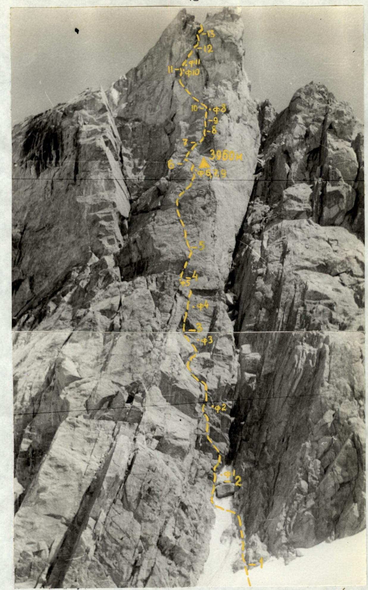
Section R0–R1. A snowy couloir with a steepness of ~45° and a length of about 70–80 m, leading to a wide rock chimney that separates the 1st and 2nd Southern bastions of the Western ridge of the peak.
Section R1–R2. Through the chimney under a rock plug via rocks of less than average difficulty on the right side of the chimney. Exit onto the plug via rocks of average difficulty on the left side of the chimney (~10 m).
Section R2–R3. From the plug vertically upwards ~35 m along a slightly overhanging, not clearly defined internal corner composed of large rock blocks to a small overhang.
Section R3–R4. From under the overhang to the right upwards 10 m along a smoothed slab with few cracks to a shelf. Climbing is complex. On the shelf, there is a convenient spot for an overnight stay. On the right side of the shelf is the 1st control point.
Section R4–R5. From the right side of the shelf to the left upwards along a vertical slab ~20 m using artificial holds. Initially, the cracks are small, but as you ascend, they become wider.
Section R5–R6. The slab becomes less steep (~75°), but movement is still on artificial holds using a system of diagonal cracks. Exit onto a large, slightly inclined shelf where a semi-reclining bivouac is possible.
Section R6–R7. Above the shelf to the right upwards is a steep internal corner with smooth walls. A gap for movement and belaying is only available at the base of the corner. The exit to the base of the lower part of the corner is organized from the left side of the shelf using artificial holds on bolt pitons (2 pitons hammered, one left). Movement along the corner is on artificial holds. In the lower part of the corner, the gap is narrow, and in the upper part, it is wider. Horizontal pitons and large chocks are used. To ensure safe passage of the last climber from the shelf on ropes on a pendulum inside the internal corner, a piton with a loop is left 10 m above the shelf for an extension.
Section R7–R8. The steepness of the corner increases. The gap becomes shallow ("blind"). For movement, petal pitons are used. Belaying on them is impossible. For belaying, hammering bolt pitons is necessary.
Section R8–R9. A sharp increase in the steepness of the corner to an overhang (~95°). Passage is along the right wall of the corner using bolt pitons.
Section R9–R10. The internal corner turns into an overhanging wide gap with wedged stones. Passage through the gap is on artificial holds using chocks. At the top of the section is the 2nd control point.
Section R10–R11. Several meters to the left upwards is a not clearly defined internal corner of variable steepness (75–90°). There are convenient gaps for hammering pitons and chocks. Movement is mainly on artificial holds.
Section R11–R12. The corner leads under a large cornice (3–5 m). From under the cornice ~20 m is a difficult diagonal traverse to the right upwards using gaps at the base of the cornice. The gap is sometimes "blind". For movement and belaying, bolt pitons are necessary.
Section R12–R13. A destroyed rock chimney with a plug at the top. Climbing is complex.
Section R13–R14. The chimney becomes less steep and turns into a strongly destroyed internal corner with a steepness of ~70°. The corner leads to the summit of the 1st Southern bastion.
Sections R14–R18 are common to routes 5A cat. diff. (Ruzhevsky's), 5B cat. diff. (Khatskevich's) via the 2nd Southern bastion and 5B cat. diff. (Frantsuzov's) via the 1st Southern bastion of the Western ridge of Jailyk peak. Descriptions of these sections can be found in the book by A. F. Naumov "Chegem-Adyr-Su".
Technical photo of the route
July 16, 1985 11:45. Shooting point #3, 500 m, 3800 m. Lens T-43 4/40 LOMO.
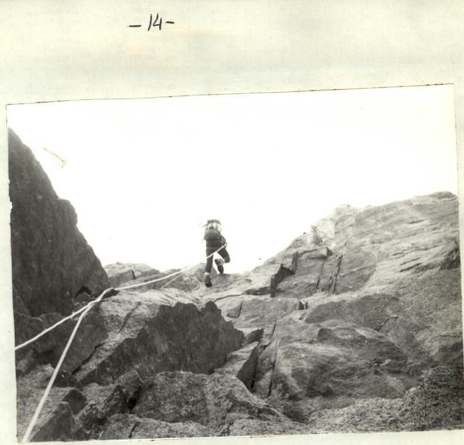
Photo 1. Passage on ropes of section R3–R4.
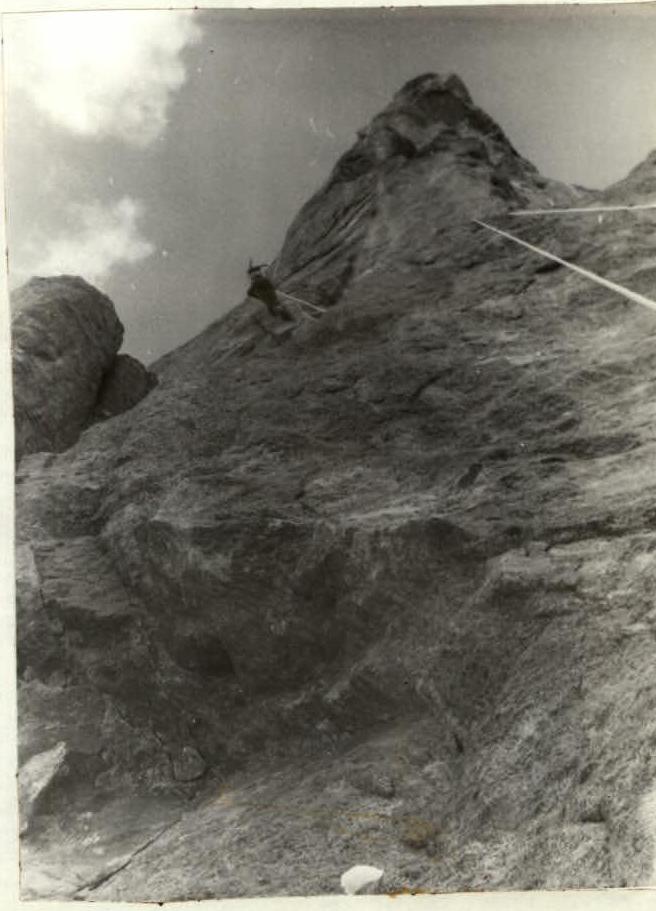
Photo 4. Ascent on ropes on section R4–R5. In the foreground is the upper part of section R3–R4.
Photo 5. Exit on ropes to point 6. In the foreground is section R4–R5.
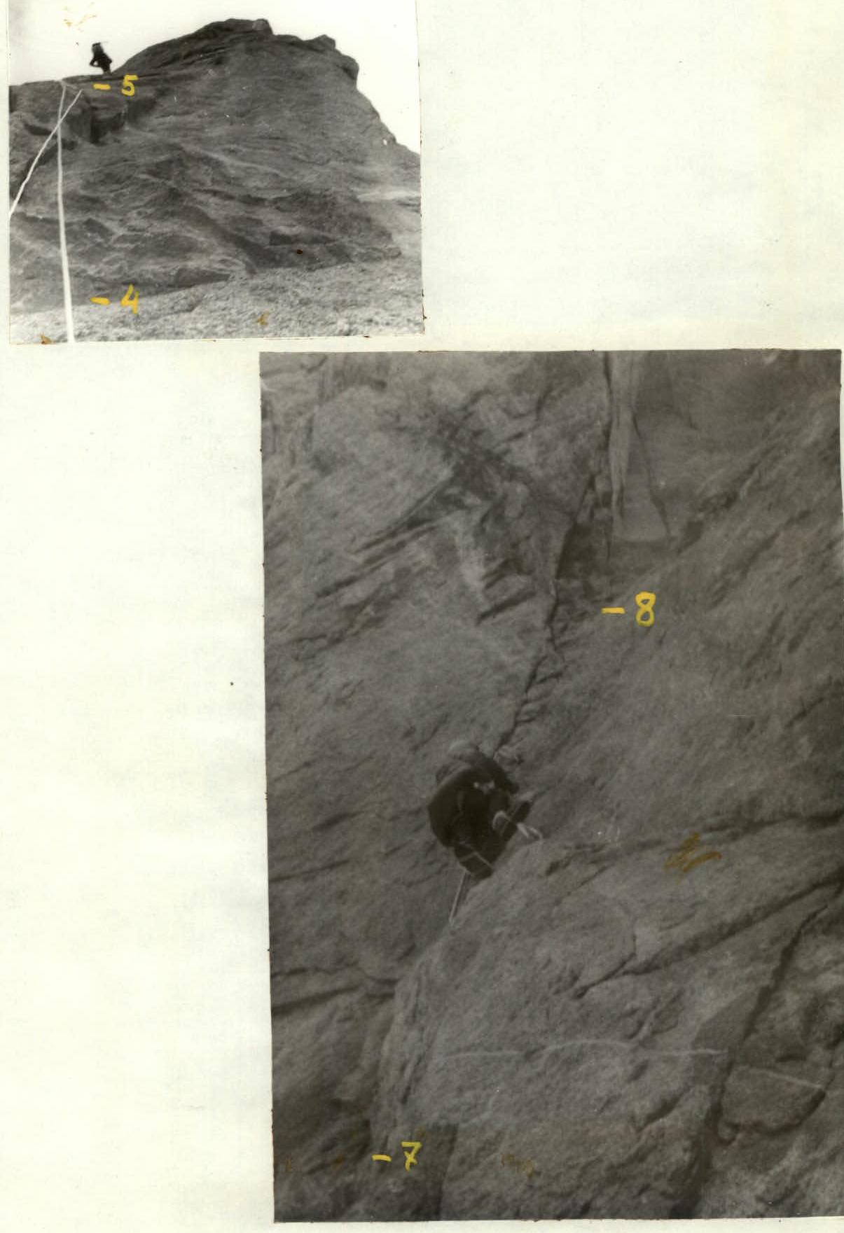
Photo 6. First climber on section R7–R8.
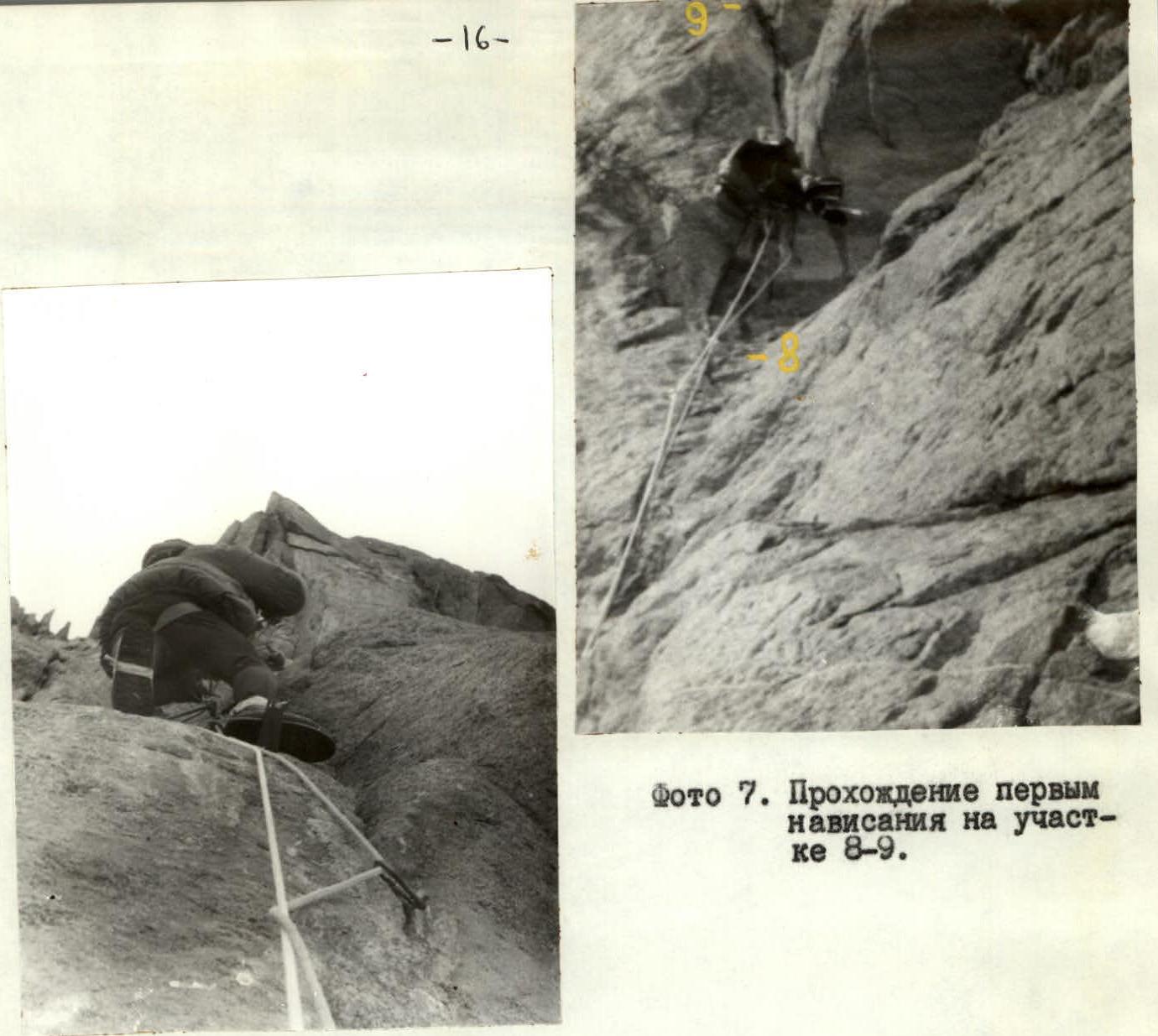
Photo 7. First passage of the overhang on section R8–R9.
Photo 8. Hammering a bolt piton at the top of section R9–R10.
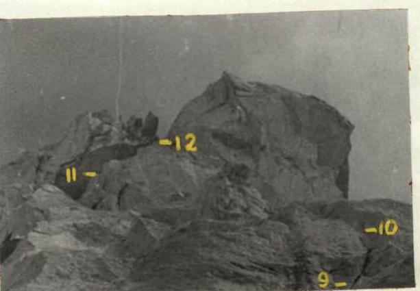
Photo 9. View of sections R9–R12.
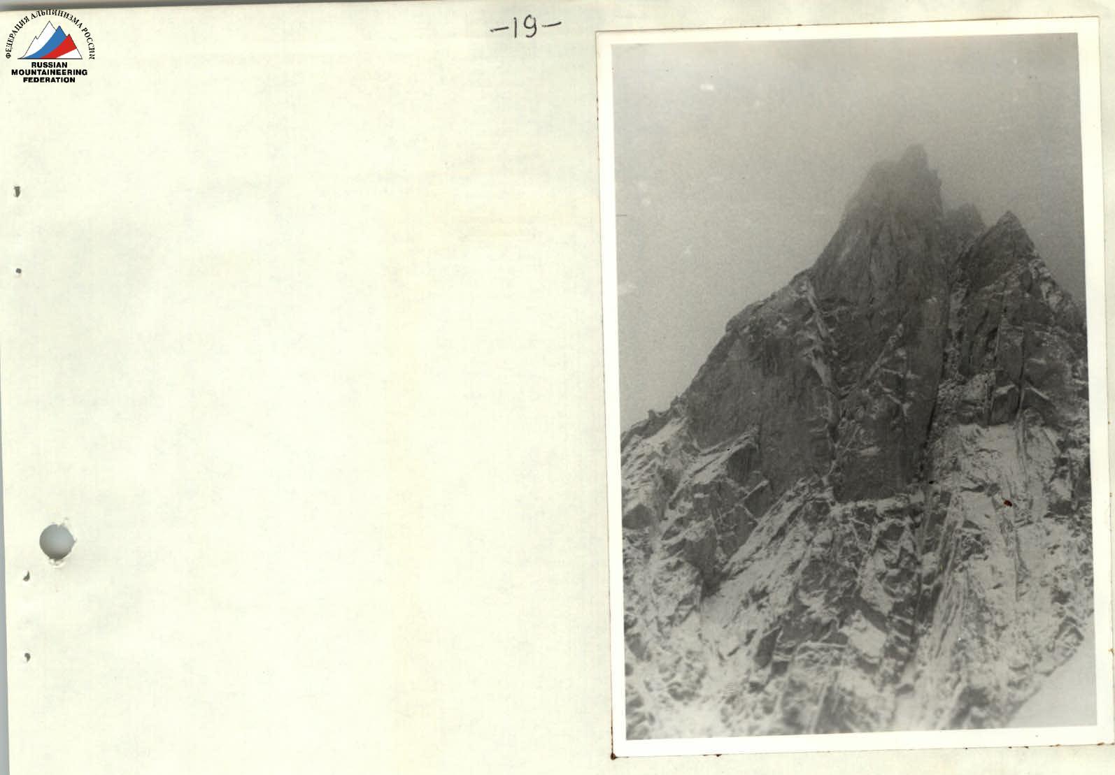
Photo 12. View of the wall in bad weather on August 15, 1987.
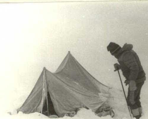
Photo 13. View of the overnight stay under the wall after bad weather on August 15, 1987.