Ascent Passport
- Ascent type: rock
- Ascent area: "in accordance with KTMVG" Caucasus, from Chipperazau Pass to Kitlod Pass.
- Peak, its height, and ascent route: Bashil — 4257 m, via the center of the West Face.
- Expected difficulty category: 5B.
- Route characteristics: height difference 780 m, average steepness 70°. Section lengths: 1st diff. cat. — 0, 2nd diff. cat. — 0, 3rd diff. cat. — 70 m, 4th diff. cat. — 415 m, 5th diff. cat. — 300 m, 6th diff. cat. — 80 m.
- Pitons driven: | For belaying | For creating artificial holds | | :----------: | :---------------------------: | | Rock — 83 | 37 | | Ice — | — | | Bolt — 3 | 3 |
- Total climbing hours — 43 hours.
- Number of nights and their characteristics: four nights: 1 — on the glacier under the wall, 2 — on a narrow rock ledge sitting, 3–4 — on a ledge in a tent.
- Surname, first name, patronymic of the team leader, participants, and their sports qualification.
- Ryzhikov Sergey Anatolyevich — Candidate Master of Sports of the USSR — team leader.
- Laskavy Delian Pavlovich — " —
- Shakalo Valery Matveyevich — " —
- Prusov Gennady Vladimirovich — " —
- Team coach, Master of Sports of the USSR, senior instructor POPOV V.P.
- Date of departure and return: July 31 – August 4, 1978.
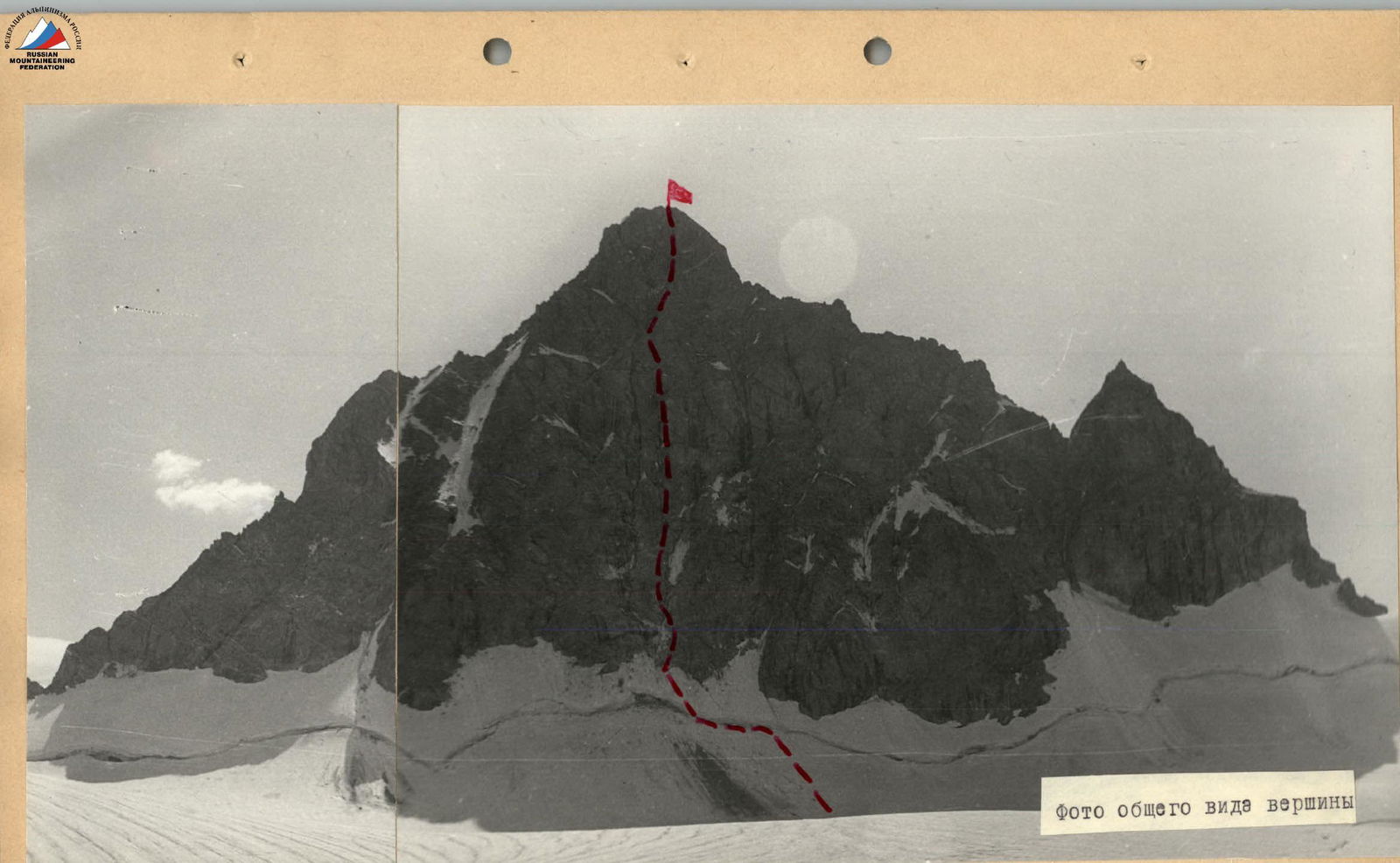
General view photo of the peak
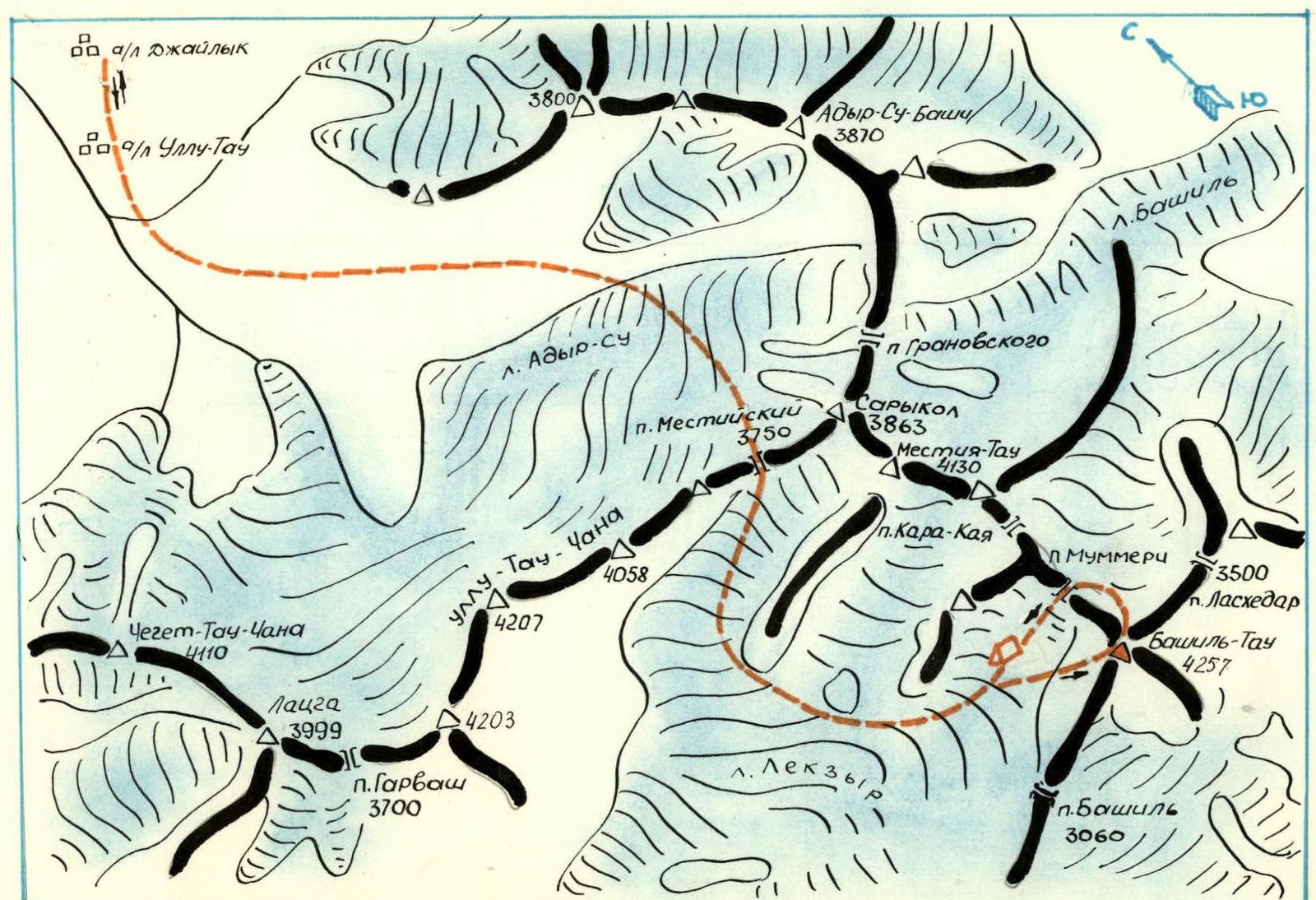
Map of the ascent area
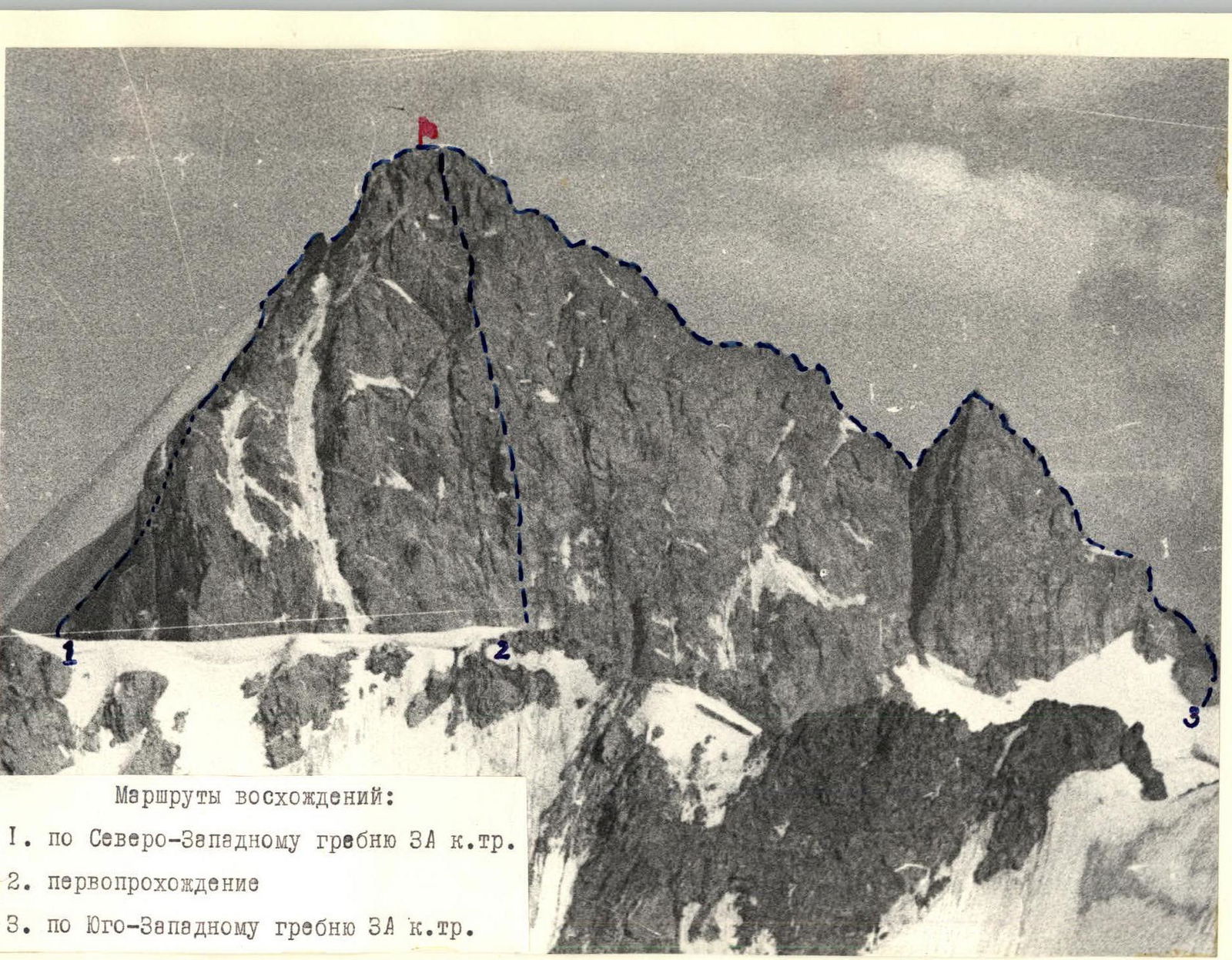
The Bashil massif is located behind the Main Caucasian Range, to the south parallel to it, and along with other peaks, it closes the upper cirque of the Lekzyr glacier. In this cirque, Bashil is the highest and nodal peak. Routes of 3A category difficulty have been laid out along all its ridges (South, East, Southwest, and Northeast). The peak is rarely visited by climbers due to its remoteness from alpine camps. To the West and South, the Bashil peak drops with sheer rock spines. The area of the massif is characterized by unstable weather, with abundant precipitation in the summer.
The West Face of the peak is cut in the middle by a huge groove — a couloir, down which powerful rockfalls often occur. Being very impressive, the West Face has long attracted the attention of climbers, including as an object of ascent within the framework of the USSR Championship. For this purpose, groups of leading climbers from the Ullutau alpine camp repeatedly studied the West Face of Bashil with the aim of organizing an ascent. However, traversing the most interesting central part of the wall remained problematic due to rockfall danger.
Having carefully studied the route during a reconnaissance sortie, a group of instructors from the Dzhaulyuk alpine camp, consisting of Laskavy D.P., Prusov G.V., Shakalo V.M., and instructor KSP Ryzhikov S.A., who assessed the safety of the planned ascent, determined that the most logical and technically simple route up the West Face is the path via the central couloir. However, its passage is in principle impossible due to the almost continuous rockfall. This couloir is a rockfall zone for the entire upper part of the wall.
Observations showed that rockfalls begin around 10:00, reaching a maximum by 12:00–13:00, and continue throughout the day. In this regard, the group developed a tactical ascent plan, according to which the lower part of the couloir should be traversed early in the morning before 10:00. Further, it was planned to move under the wall to the right of the couloir and continue the ascent up the wall. The first attempt to conquer the wall was thwarted by prolonged bad weather. The group's next sortie was successful. The ascent, which began in good weather on the third day, was halted by a prolonged cyclone. However, the group this time took into account the specific weather conditions of the area, was prepared for prolonged bad weather, and, having waited out the cyclone for two days, reached the summit on August 3, 1978.
Brief description of the approach to the route
From the Dzhaulyuk alpine camp, follow the trail that initially runs along the left bank (in the direction of travel) of the Adyrsu River, then to the left of its glacier, and ascend to the hut under the Mestia Pass. The journey takes 3 hours.
From the hut, move up to the right:
- initially across the rigidly sloping glaciated glacier, bypassing the first Hitzon to the right;
- then across the glaciated glacier with a subsequent bypass of the second Hitzon to the left, in the direction of the Mestia Pass.
From the hut to the pass — 1.5 hours.
Descend from the pass onto the Lekzyr glacier along the right edge of the glaciated glacier:
- initially along the glaciated ice ridge;
- then along the snowy slopes in the direction of the first lateral moraine.
Ascend along the left side (in the direction of travel) of the Lekzyr glacier into its upper cirque to the branch flowing from the Lekzyr – P (Mummery) Pass. Ascend to this branch from the left. Having reached the part of the glacier branch leading to the pass, turn towards the West Face of the Bashil peak. Overnight at the wall.
TABLE of route sections
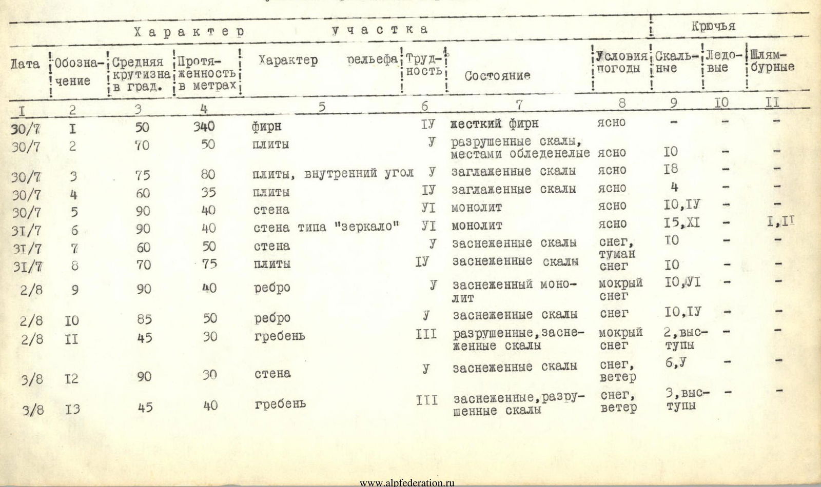
Brief explanation of the table of route sections
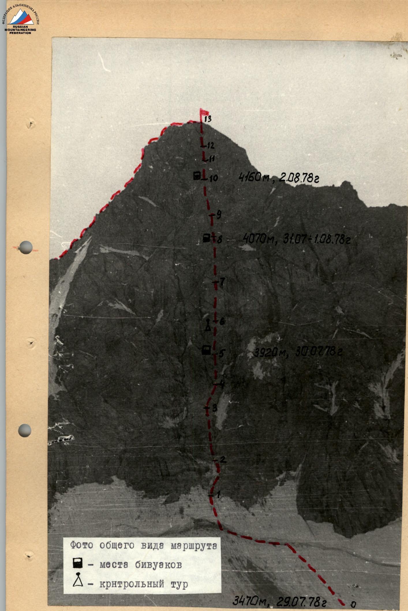
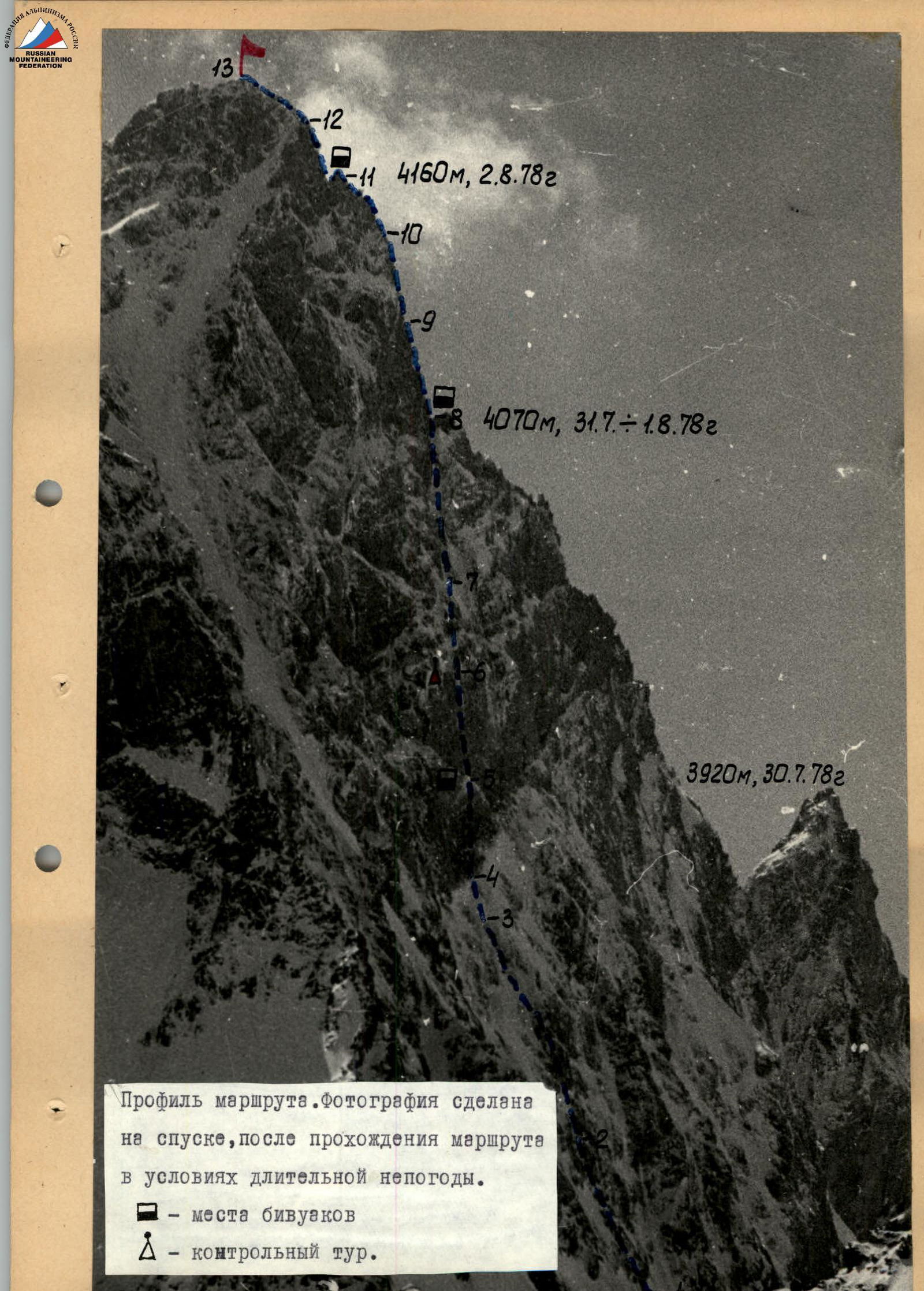
Having departed (no later than three hours) from the bivouac on the glacier under the West Face of the Bashil peak, ascend via the firn to the bergschrund under the wall, to the right of the traces of a powerful rockfall. Further, moving to the left along the lower edge of the widely torn bergschrund, reach its narrowing. Using artificial holds, cross the bergschrund. Ascend via the steep firn to the rocks of the giant rockfall-prone couloir (R1, 340 m).
Bypass snow-covered icy slabs of moderate difficulty via the rocks (R2, 50 m). Continue ascending straight up, difficult climbing up steep, smoothed, and partially destroyed slabs, bypassing steep, snow-covered rocks, to a destroyed internal corner (R3, 80 m, the first ascends without a backpack). On the right side of the internal corner (live rocks, difficult climbing), exit onto smoothed slabs of moderate difficulty (R4, 35 m).
Approach the rock overhang closing the right part (in the direction of travel) of the rockfall-prone couloir via the slabs. The entire route up to this point must be traversed by 14:00.
The overhanging rocks are monolithic, smooth, with few holds, and partially overhanging. The first ascends with very difficult climbing in galoshes, using artificial holds. Backpacks are pulled up. (R5, 40 m). The overhang ends with a wide ledge, on which a platform was laid out and a bivouac organized. From the bivouac on the glacier under the wall — 12 hours.
From the platform, ascend with very difficult climbing up and to the left via:
- sheer,
- partially overhanging,
- monolithic rocks resembling mirrors,
in galoshes, using:
- artificial holds,
- ladders,
- platforms.
There are very few holds and cracks; it is necessary to drive in bolt pitons. (R6, 40 m).
A control cairn is suspended above the ledge in the upper part of the wall. Via a diagonal vertical crack in the upper part of the wall, going up and to the left, exit onto steep, difficult, and above moderate difficulty rocks of the wall (R7, 50 m). Above the wall are steep slabs of above moderate difficulty, which must be ascended to a wide ledge (R8, 75 m, backpacks are pulled up). A bivouac was organized here. From the bivouac on the ledge — 14 hours.
Upon traversing R8, the weather suddenly deteriorated — snow began to fall, fog descended — and remained so until the end of the ascent. From the bivouac site, ascend up and to the left via:
- difficult, sheer, wet rocks (R9, 40 m),
- then more sloping, snow-covered rocks,
- exit onto a rock ridge of moderate difficulty (R11, 30 m), leading to the wall.
At the wall — bivouac. From the previous night's bivouac on the ledge — 12 hours.
From the bivouac, ascend via steep, difficult rocks of the wall, using artificial holds (R12, 30 m), to the pre-summit tower. Via rocks of moderate difficulty and destroyed rocks of the tower, ascend to the summit (R13, 40 m). From the bivouac to the summit — 5 hours. From the summit, via the Northwest Ridge (route 3A cat. diff.) — to the Lekzyr – P (Mummery) Pass.