July 28, 1981
To the Judging Committee for the Caucasus Alpine Championship among alpine camps and tourist clubs.
Copy: To the Classification Committee of the USSR Alpine Federation.
Conclusion
On the ascent of the "Bashil" peak by the team from the "Ullutau" alpine camp as part of the 1st Caucasus Alpine Camps Championship 1981.
- The route of the first ascent to the "Bashil" peak via the south wall was completed by the team in accordance with the Alpine Competition Rules and the Championship Regulations.
- The route corresponds to the claimed route and matches the one marked on the photograph in the application.
- The name of the route in the application — "Bashil" via the center of the south wall — should be changed as follows: — "Bashil" via the right part of the bastion of the south wall.
- Team composition: according to the application, the following team members started the route:
- Merlis V.P. — Master of Sports, instructor 3rd category, captain
- Kuznetsov Kh.K. — Candidate Master of Sports, —"— 2nd — deputy
- Kuznetsov Yu.N. — Master of Sports, —"— 1st — participant 50% changed —
- Bottaev A.Zh. — Candidate Master of Sports, —"— 2nd —"—
- Gonchar I.I. — Candidate Master of Sports, —"— 2nd —"—
- Efanov A.V. — Candidate Master of Sports, —"— 2nd —"—
- Based on the materials of the first ascent to the "Bashil" peak via the right part of the bastion of the south wall, the classification committee of the "Adyrsu" valley requests the Classification Committee of the USSR Alpine Federation to include it in the table of peaks of the mountain regions of the USSR as a category 5B route.
Head of the "Adyrsu" valley tourist club — V.P. PETUKHOV
 www.alpfederation.ru
www.alpfederation.ru
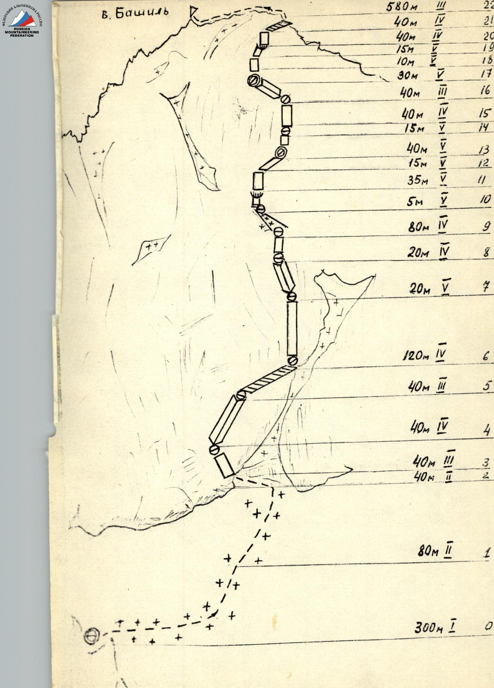
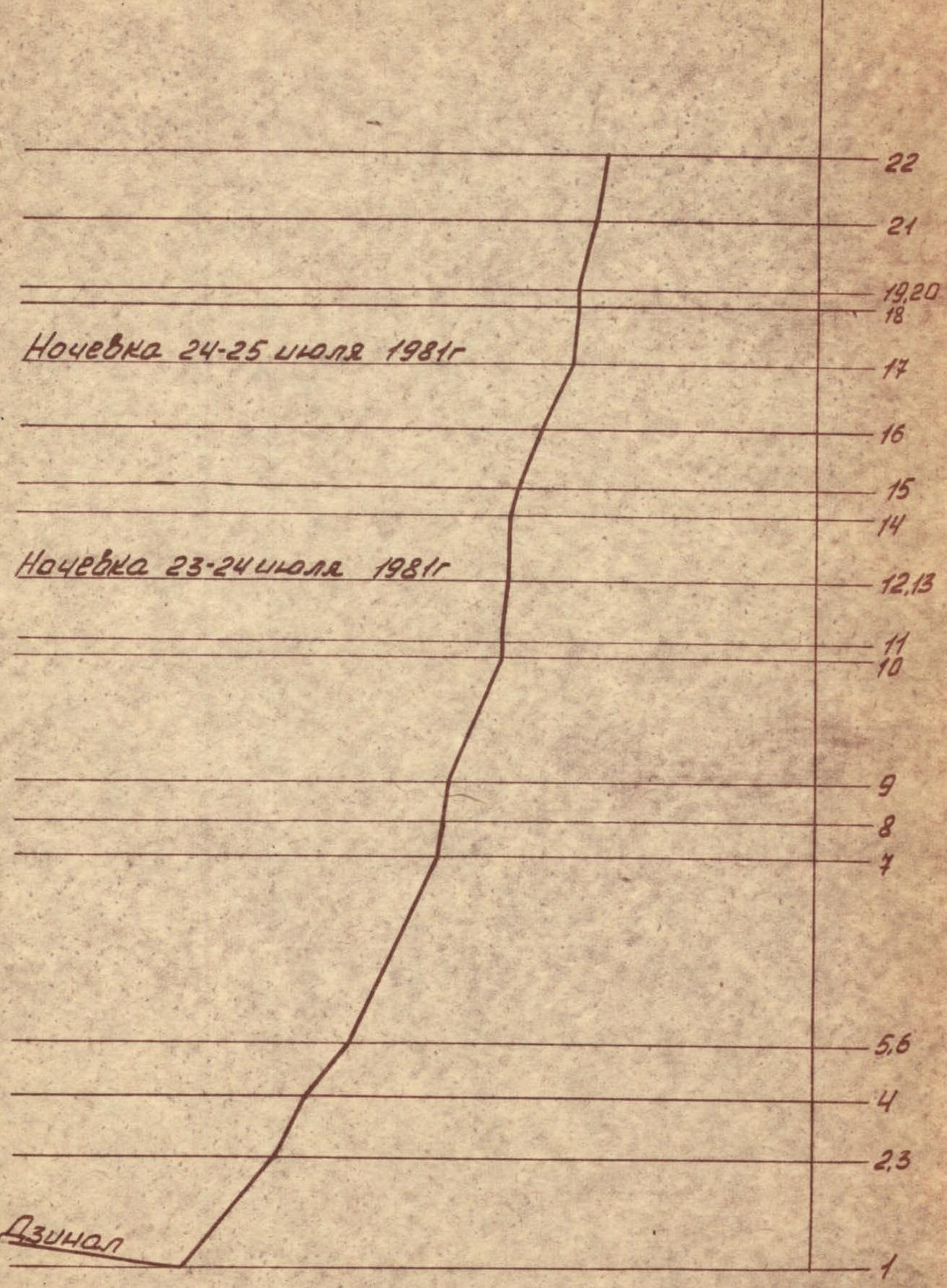
Volume 2. Route Profile. Projection diagram of the wall part of the route (without the ridge part)
Approach to the Route Description
From the "Ullutau" alpine camp, follow the trail along the left bank of the Adyrsu river upstream to the "Mestia" campsite. From the camp to the campsite — 2–3 hours.
From the "Mestia" campsite, follow the left-bank moraine to the tongue of the Adyrsu glacier, cross it, and reach the scree of the rocky island. Bypass the island on the left and ascend the trail to the hut on top of the island. From the camp to the hut — 2–3 hours.
From the hut, head east towards the steep 70–80-meter ice-snow ascent and climb along the right side of the rocks to the plateau. Cross the plateau, turn right, and follow the snowfields and slopes of the Adyrsu glacier, crossing crevasses via snow bridges, to reach the snow plateau of the Mestia pass. From the hut to the pass — 2.5–3 hours.
From the pass, staying on the right side of the Mestia plateau, bypass the icefall, and descend to the platforms on the moraine under the southern slopes of the Ullu-Tau East peak — "Moraine Lekzyr". From here, cross the eastern branch of the Lekzyr glacier (closed crevasses) and approach the col of the Bashil pass.
From the glacier, climb a steep ice-snow slope, crossing the bergschrund, to reach the col in the southwest ridge of the Bashil peak (left of the Bashil pass). From the Mestia pass — 4–5 hours.
On the col, after preparing a platform, a tent was set up — the initial bivouac.
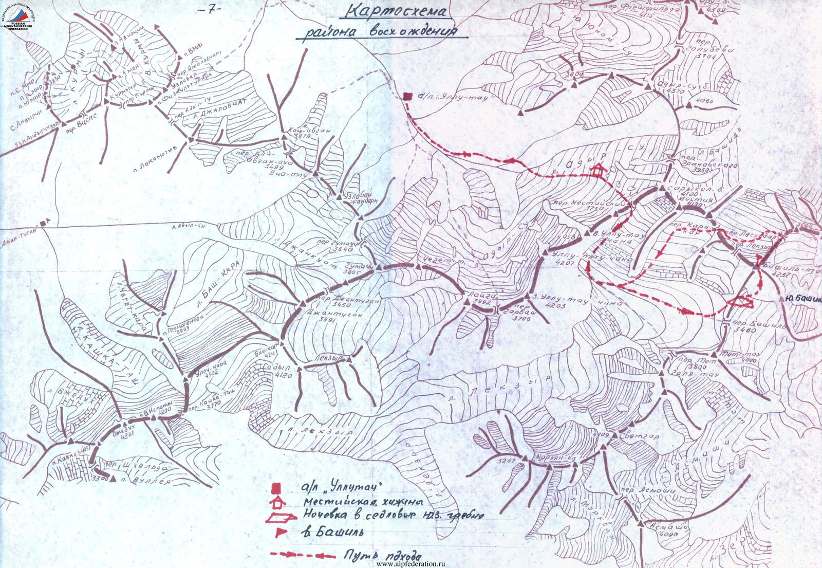 a/l "Ullutau"
Mestia hut
Bivouac on the col of the SW ridge of the Bashil peak
--- Approach route
a/l "Ullutau"
Mestia hut
Bivouac on the col of the SW ridge of the Bashil peak
--- Approach route
Description of the Ascent
Explanatory Note to the Table (Appendix 2)
July 21, 1981. The group left the camp at 15:30 and stopped at the "Mestia" hut for a bivouac at 19:50. Time taken from the camp to the hut — 4 hours.
July 22, 1981. Leaving the hut at 6:30, the group, along with two detachments of trainees carrying equipment and supplies under the guidance of the team coach, K.K. Zaitsev, reached the initial bivouac site on the col of the southwest ridge of the Bashil peak by 15:00 (see approach description). Here, on the col, a platform was cleared and a tent was set up. From the hut to the col — 8 hours.
The rest of the day was used for a visual inspection of the south wall from the Dzinál glacier, identifying potential rockfall paths, clarifying the main ascent route, the exit point to the route, and photographing the ascent route.
It should be noted that due to the nature of the ridges and counterforts surrounding the peak, finding a vantage point to capture the entire profile of the route is practically impossible.
July 23, 1981. Departure from the bivouac at 6:40, descending 300 meters down to the relatively flat Dzinál glacier, to the start of the route. The starting point of the route is marked by a large snow couloir rising steeply from right to left under the wall part of the route.
On a snow slope with an incline of up to 45°–50°, to the right of the debris from the couloir, ascend 80 meters up to the bergschrund, and then 40 meters along the lower edge of the bergschrund, traversing the couloir almost across its entire width, to transition to its left rocky part (dangerous due to potential rockfall from the bergschrund, crossing done one at a time with variable protection, quickly).
The rocky left part of the couloir (40 meters), with an incline of 60°, featuring good ledges, leads to a large internal angle. The upper part of the internal angle contains many "live" rocks. After 40 meters, exit the internal angle onto a ledge. Here, for orientation, a control cairn was established at the start of the route.
| Date | Designation | Average steepness, degrees | Length, meters | Nature of the relief | Difficulty | Condition | Weather conditions | Rock pitons | Ice pitons | Bolts |
|---|---|---|---|---|---|---|---|---|---|---|
| July 21, 1981 | Approach from the camp to the "Mestia" hut | |||||||||
| Departure from the camp at 15:30. Arrival at the bivouac at 19:50. Total hours — 4. Overnight stay in the hut. | ||||||||||
| July 22, 1981 | From the "Mestia" hut, approach under the south wall of the Bashil peak | |||||||||
| Departure from the hut at 6:30. Arrival at the bivouac at 15:00. Total hours — 8. Overnight stay on the col of the SW ridge of the Bashil peak in a tent, lying down. | ||||||||||
| July 23, 1981 | 0–1 | 5–10 | ~300 | From the SW ridge down to the Dzinál glacier to the base of the large snow couloir. | 1 | Closed glacier | Good. | Simultaneously | ||
| 1–2 | 45–50 | 80 | Snow slope | 2 | Dense snow | —"— | Simultaneously | |||
| 2–3 | Traverse | 40 | 2 | —"— | Alternating, ice axe | |||||
| 3–4 | 55 | 40 | Rocky wall | 3 | "Live" rocks | —"— | 3 ledges | |||
| 4–5 | 50 | 40 | Internal angle | 4 | —"— | —"— | 2 ledges | |||
| 5–6 | Traverse | 40 | Ledges | 3 | —"— | —"— | 2 ledges | |||
| 6–7 | 55–65 | 120 | Wall | 4 | —"— | —"— | 5 ledges | |||
| 7–8 | 75 | 20 | Internal angle | 5 | —"— | —"— | 4 ledges | |||
| 8–9 | 80 | 20 | Wall | 4 | Monolithic, water | —"— | 4 ledges | |||
| 9–10 | 65 | 80 | Couloir | 4 | Snow | —"— | 4 | |||
| 10–11 | 85–90 | 5 | Wall with an overhang | 5 | Monolithic | —"— | 2 | — | — | |
| 11–12 | 85 | 35 | Wall | 5 | —"— | —"— | 5 | |||
| Departure from the bivouac on the col at 6:40. Arrival at the bivouac at 18:20. Total hours — 11. Overnight stay on the wall/on a ledge/in a tent, semi-reclining. | ||||||||||
| July 24, 1981 | 12–13 | 80 | 15-traverse | Wall | 5 | Monolithic | Good | 4 | ||
| 13–14 | 85–90 | 40 | —"— | 5 | —"— | —"— | 5, VII | |||
| 14–15 | 75 | 15 | —"— | 5 | —"— | Satisfactory | 3 | |||
| 15–16 | 70 | 40 | —"— | 4 | Broken rocks | Poor — Rain with snow | 3 | |||
| 16–17 | 65 | 40 | Internal angle | 3 | —"— | Poor — Snow grains | 2 | |||
| Departure from the bivouac at 9:00. Arrival at the bivouac at 17:30. Total hours — 8. Overnight stay (5 people) on a ledge in a tent, semi-reclining; the sixth person on a second ledge 5 meters above, under a cloak. | ||||||||||
| July 25, 1981 | 17–27 | 80 | 30 | Wall | 5 | Monolithic | Good | 6, IX | ||
| 18–19 | 90 | 10 | —"— | 5 | —"— | —"— | 2 | |||
| 19–20 | 80 | 15-traverse | Wall with a cornice | 5 | —"— | —"— | 4 | |||
| 20–21 | 75 | 40 | Wall | 4 | Broken | —"— | 3 | |||
| 21–22 | 80 | 40 | Ledges | 3 | —"— | —"— | 2, ledges | |||
| 22–23 | 0–70 | ~580 | Ridge | 3 | —"— | —"— | 4, simultaneously and alternating, ledges | |||
| Departure from the bivouac at 8:20. Arrival at the bivouac at 20:30. Total hours — 11:30. Overnight stay on the Lasheddar pass in a tent, lying down. |
Note. The total time of walking hours per day does not include time for rest and food, as well as the exit to the snow directly under the rocks of the right wall. Here, the group replenished their water supply (5 liters). The wall is dry, and it is only possible to replenish water supplies on the snowfield in the upper part of the wall, before exiting to the ridge.
On snow (80 meters) with piton protection, hammering pitons into the wall to the right of the ascent route — exit under a large wedge-shaped fragment at the base of the wall, identified as a landmark from the Dzinál glacier. From the snow, ascend to the right and up (section R10–R11) via a 5-meter wall with an overhang, and then along an 85° wall (section R11–R12), difficult climbing (35 meters), to reach the fragment. The first sections R10–R12 were climbed in galoshes without a backpack using ladders; the rest were climbed with self-arrest. The last climber reached the fragment at 18:20. Here, an overnight stay was organized (after preparing the platform). The platform did not allow for comfortable accommodation — an overnight stay was semi-reclining in a tent.
July 24, 1981. At 9:00, the first pair (Merlis — Gonchar) started processing the route. Immediately from the bivouac, a difficult 15-meter traverse to the right and up, 40 meters (section R13–R14), very difficult (5–6 category) climbing using ladders, with few cracks. The pair worked without backpacks, in galoshes.
From here, two ropes were pulled up with a counterweight from below. The length of the pull was 40 meters.
Then, the rope was straightened, and the rest ascended using ascenders with étriers or ladders, straight up.
From the ledge, traverse 15 meters to the right and up, overcoming steep walls (40 meters) of above-average difficulty — exit into a large internal angle with many "live" rocks. At the exit from the angle, under a sheer monolithic wall — a ledge. To the right and above — a characteristic landmark — a "red" triangle-niche.
The weather started to deteriorate from midday: rain mixed with snow began, followed by snow grains, visibility was lost, and it became cold. The group decided to spend the night. After 2.5 hours of work organizing a platform on the ledge, it was possible to set up a tent that could accommodate 5 people, sitting and semi-reclining. The sixth person spent the night 5 meters above on a second ledge, covered with a cloak.
While four team members organized the bivouac, a pair processed the route further. Up from the bivouac — a vertical wall 30 meters, 85° with an internal angle at the top, very complex climbing (10 meters — 90°), few cracks, no holds. Ladders were used. The wall ends on a small ledge where two people can barely fit. From the ledge — a very difficult traverse (section R19–R20) to the right, exiting onto a small cornice (constantly deflecting) and then up onto broken rocks.
After processing two ropes, the pair descended to the bivouac on July 25, 1981.
On the morning of July 25, the weather was excellent, with good visibility. A control cairn was established on the edge of the platform. At 8:20, movement resumed — ascending the previously fixed ropes using ascenders with étriers or ladders (40 meters) (section R17–R19). Then — a 15-meter complex traverse, complex even when following the already established ropes, and an exit onto simpler but quite steep broken rocks. Here, three people can gather. A control cairn was established.
After 80 meters of movement along broken rocks of a blocky type — exit onto the south ridge.
Along the ridge, with average difficulty, overcoming a series of small walls, with alternating and simultaneous protection (12 ropes) — exit to the summit of Bashil. Time of exit — 15:50.
Descent from the summit via the east ridge (route 3A category): initially on snow and ice with piton protection, then along rocks to the Lasheddar pass. The last person descended to the pass at 20:30. Overnight stay on the prepared platform.
July 26, 1981. Departure from the bivouac at 9:00, via the Karakaya pass — Moraine "Lekzyr" — Mestia pass, return to the "Ullutau" alpine camp.
Geographical Description and Sporting Characteristics of the Ascent Area
The Bashil peak (4257 meters) is a nodal peak of the Main Caucasus Range, in the upper reaches of the Chegem river, located between the Lasheddar pass, followed by the eponymous peak to the east, and the Lekzyr pass, further the Karakaya-Lekzyrskaya pass to the northwest. Two ridges extend from the Bashil peak — the southwest and south ridges.
The southwest ridge descends to the Bashil pass, behind which stands the solitary Tot peak. In the south ridge is located the South Bashil peak.
Four ridge routes of category 3A difficulty have been established on the Bashil peak (along the S., SW., E., and NW. ridges) and one wall route of category 5B — along the west wall.
To the south, east, and north, the Bashil peak is bounded by sheer walls.
The area is currently relatively rarely visited by mountaineers.
History of Exploration
- Exploration of the peak began in 1930 when, on July 30, B. Delone, A. Bell, and I. Tamm ascended the peak via the S. ridge, category 3A.
- In the pre-war years, routes were completed on the peak via the E. ridge, category 3A (B. Simagin, T. Rozhdestvensky — July 2, 1935) and via the N. ridge, category 3A (I. Kunaev et al. — August 21, 1940).
- Then, only in 1978, on August 4, a first ascent was made on the peak via the west wall, category 5B, by a group from the "Dzhailyk" alpine camp: S. Ryzhikov, D. Laskavy, G. Prussov, V. Shakalo.
The first ascenders to the Bashil peak were foreign climbers L. Rolleto, T. Longstaff, who on August 15, 1903, ascended the peak via the SW ridge, category 3A.