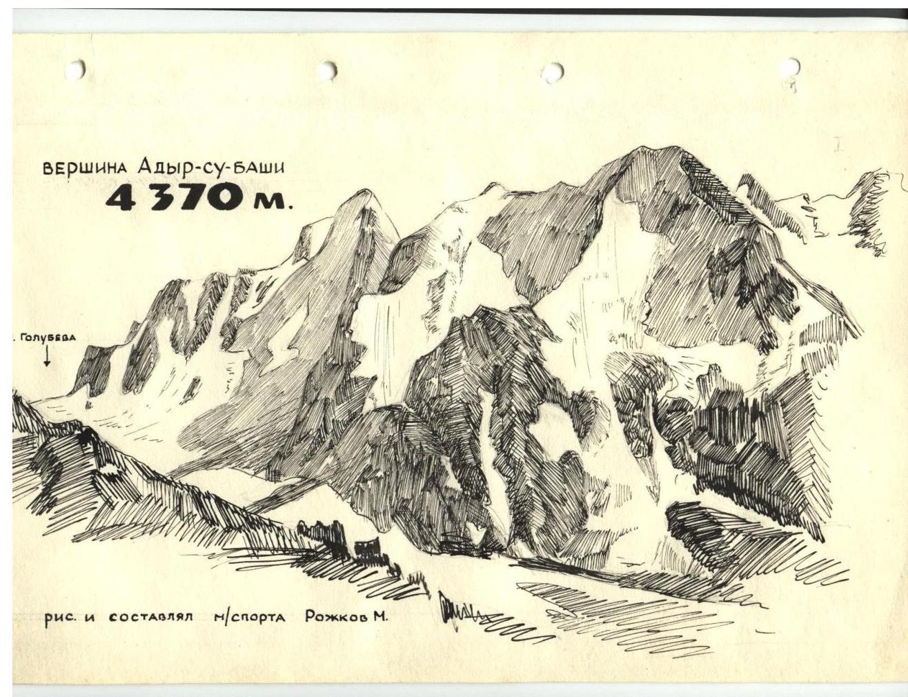
Adyr-Su-bashi from the Golubeva pass (via the north-east ridge) 5B cat. diff., 4370 m, combined route type
The Adyr-Su-bashi peak is located in the Adyr ridge of the Main Caucasian Range.
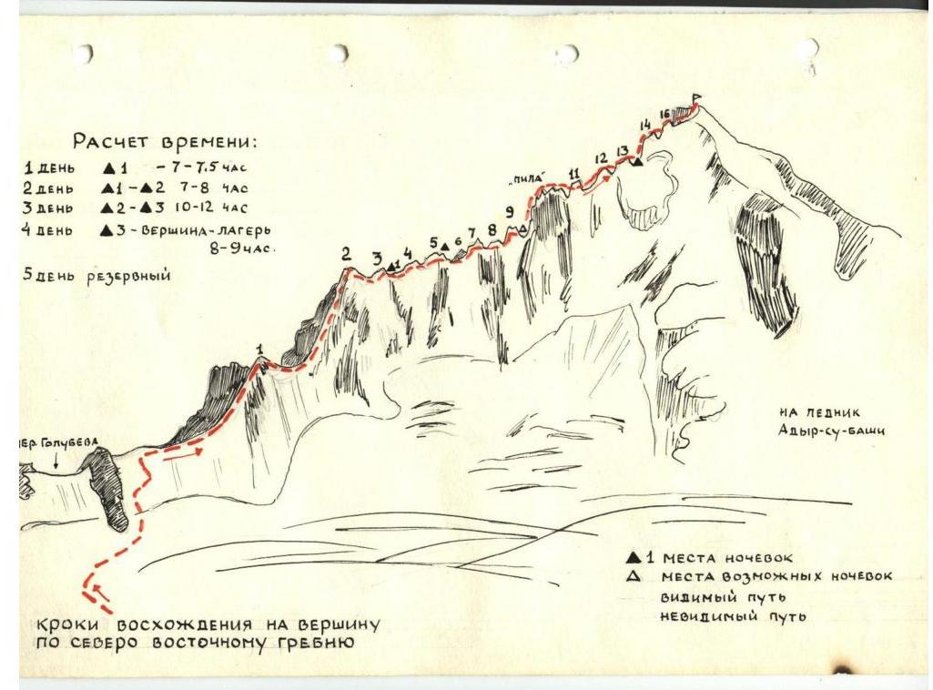
The north-east ridge is a long, heavily dissected ridge with sheer and high "gendarme" peaks separated by saddles. The rocks are mostly slab-like, heavily snow-covered, and partially icy. For the ascent, 10-12 rock and 4-6 ice pitons are required. Particularly difficult sections include:
- bypassing "gendarme" #4
- exiting the snowy ridge via a crack onto the rocks of "gendarme" #5
- ascending the snow-covered, icy slabs to the summit of "gendarme" #5
- ascending "gendarme" #10
- ascending the pre-summit rise ("gendarme" #11, 12, 13)
Route Description
Day 1. From the camp, the path goes up the Kuldumkol-Su valley to the J. Bnom-Su glacier, in the upper reaches of which lies the Golubeva pass. To the right of it is an auxiliary pass, from which the ascent along the ridge begins. The journey from the camp to the pass takes around 5 hours.
The first two "gendarme" peaks are straightforward and are ascended directly, bypassing the summit on the right. Between "gendarme" peaks I and 2 lies a rocky saddle composed of loose, brittle rocks.
"Gendarme" peaks 2 and 3 are connected by a snowy saddle (60 m) with a small cornice to the east; the saddle gradually becomes more challenging and transitions into the steep, loose rocks of "gendarme" peak 3, which are covered in snow, requiring careful belaying. The summit of "gendarme" peak 3 is bypassed on the right, exiting onto a weakly defined shoulder on the western counterfort, and then continuing up the snowy ridge.
From "gendarme" peak 3, descend along the ridge and wall (5-7 m) to the saddle before "gendarme" peak 4. At the end of the ridge, there is a well-developed platform suitable for an overnight stay. The journey from the Golubeva pass to this point takes 2 hours.
Day 2. After the platform, an acute snowy ridge (50 m) follows, transitioning into the sheer rocks of "gendarme" peak 4, which is bypassed at its base on the right along the edge of ice, snow, and rocks. The rocks are " заливистые" with a small number of cracks, the ice is covered with a thin layer of firn, and the steepness reaches 60°. The bypass route is around 90 m long and takes 4-5 hours, requiring mandatory pitons for belaying, partially on rocks and partially on ice.
From the base of "gendarme" peak 4, an acute snowy ridge leads to "gendarme" peak 5, rising steeply. The ascent to "gendarme" peak 5 is made directly from the snowy ridge via a rocky crack and then along the slabs. The rocks of "gendarme" peak 5 are monolithic slabs with a steepness of 45-50°, partially icy. The most challenging sections include the exit from the snowy saddle onto the rocks and certain sections of the slabs, requiring careful piton belaying. The ascent from the saddle to the summit of "gendarme" peak 5 takes 3 hours, where there is a platform suitable for an overnight stay.
Day 3. From "gendarme" peak 5, descend along a rocky ledge to the snowy saddle leading to "gendarme" peak 7, bypassing "gendarme" peak 6 on the left. The ascent to "gendarme" peak 7 is straightforward.
The descent to the saddle between "gendarme" peaks 7 and 8 is made along a steep snowy slope (30-40 m). "Gendarme" peak 8 is ascended directly, without bypassing it on the left via the scree. The descent is made along a steep, slab-like section of rocks with a crack on the left, followed by a traverse to the right along the snow and down to the saddle. The distance from the summit of "gendarme" peak 8 to the saddle is 60 m.
Between "gendarme" peaks 8 and 9 lies an acute snowy ridge, from which there is a straightforward ascent to "gendarme" peak 9 directly along the acute, steep rocky ridge composed of monolithic rocks.
From the saddle, a route can be seen bypassing "gendarme" peak 9 along ledges, but they end in a sheer wall. The ascent to "gendarme" peak 9 appears challenging and hazardous but is actually straightforward. The journey from "gendarme" peak 9 takes 1 hour.
From the summit of "gendarme" peak 9, a ridge - a counterfort - extends to the southeast, consisting of smooth, "залистанные" slabs. The descent should be made towards the main ridge along a slab about 5 meters down, where an old piton with a loop is found, followed by two more pitons below. From the upper piton, a small crack leads down, followed by smooth, even slabs with horizontal cracks. The descent from the piton to the saddle (15 m) is made using a thigh-shoulder rappel. "Gendarme" peak 9 is ascended in 1.5 hours.
The saddle between "gendarme" peaks 9 and 10 is snowy, with snowdrifts - a suitable location for an overnight stay.
The snowy ridge rises steeply, transitioning into the frozen scree of "gendarme" peak 10, partially covered with icy snow. The wall of "gendarme" peak 10 is ascended on the right side via a crack (2 m). The route to the summit is along snow-covered, icy slabs with few handholds. The final 10 meters to the summit are ascended along ledges. Throughout the ascent, careful piton protection is necessary.
The descent from the summit of "gendarme" peak 10 to the saddle before the "rocky saw" is made along an inclined, dissected slab. "Gendarme" peak 10 is ascended in 1-1.5 hours.
Next, traverse to the summit plateau, overcoming a cornice 1-1.5 m high. The journey along the snowy plateau to the summit takes 30 minutes. From "gendarme" peak 13 to the summit takes 3 hours.
The descent from the summit follows route 3A cat. diff. into the Adyr-Su valley.
The "saw" is a heavily dissected rocky ridge consisting of six "gendarme" peaks, which are ascended directly. Before the "saw" lies a suitable location for an overnight stay.
Initially, the path follows the ridge of the "saw" for around 30 m to a sheer wall (15-18 m), from which a rappel is made onto the scree on the eastern side of the ridge. Here, there is a platform suitable for an overnight stay.
The next tooth of the "saw" after the scree saddle is ascended directly with piton belaying; the descent from the summit is made by rappel (around 10 m).
The ascent to the next tooth is made with piton belaying, the summit is bypassed on the right, and the next tooth is bypassed on the left along the crack and exit onto the saddle before the final tooth of the "saw". The ascent to the final tooth is made along an inclined shoulder; the descent is made by rappel (10-12 m).
After the rocky "saw", an acute snowy ridge with icing follows, leading to the pre-summit rise.
From the last tooth of the "saw" to the shoulder of the counterfort of "gendarme" peak #11 takes 4 ropes, and from the shoulder to the summit of "gendarme" peak #11 takes one rope.
The ascent to "gendarme" peak #11 is initially made along a snowy, gradually complicating ridge, which reaches a steepness of 45° at the shoulder of "gendarme" peak #11. From the shoulder, proceed along the snow; the snow-covered rocky slabs are bypassed on the right along the edge of ice and rocks, with the summit of "gendarme" peak #11 (8 m) bypassed on the right, after which the snowy saddle before the rocky wall is reached.
The ascent from the last tooth of the "saw" to the summit of "gendarme" peak #11 takes 2 hours 30 minutes.
The wall is ascended by bypassing it on the right:
- initially, ascend 4-5 m to the right upwards along the wall (where an old piton is found)
- then along the edge of ice and overhanging rocks,
- followed by ice to reach a ledge before the wall (2-3 m).
After passing the wall, ascend slabs with few handholds using piton belaying, then exit onto a saddle, and finally onto loose, snow-covered rocks before the ridge leading to "gendarme" peak #12, which is bypassed on the right.
The approach to "gendarme" peak #12 is made along challenging rocks. Next follows 30 m of steep snowy ridge leading to the summit of "gendarme" peak #13.
Day 4
The last three "gendarme" peaks are bypassed on the right along the route.
Under "gendarme" peak #14 lies a snowy hollow - a suitable location for an overnight stay.
From "gendarme" peak #13 to "gendarme" peak #14 lies a narrow snowy ridge.
From "gendarme" peak #14, descend to the saddle and icefall, bypassing it on the right with an exit onto a snowy shoulder to the right of "gendarme" peak #16.
Upon exiting onto the ridge, a 3-meter ice wall is encountered, which is ascended with piton belaying.
Next, ascend along a snowy ridge with a cornice 50-60 m long, which leads to the pre-
Footnotes
-
SKETCHES OF THE EAST RIDGE TO THE SUMMIT VIA THE NORTH-EAST RIDGE ↩

