8-2.4.1.173
Main Caucasian Range and its spurs from the Chipperazau Pass to the Ortokara peak
Report
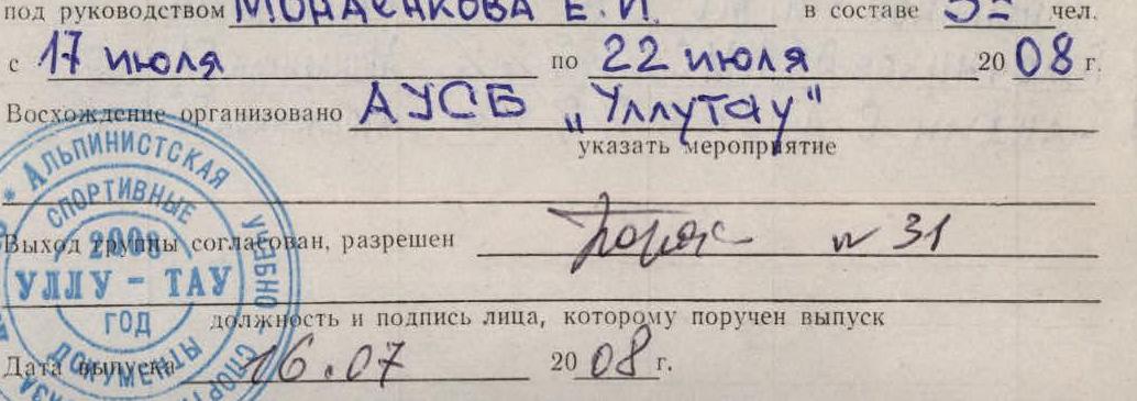
on the first ascent to the Adyrsu peak (4370 m) via the South-West wall through the central bastion in the period from July 19 to July 22, 2008 by the sports group of AUSB "Ullutau" consisting of:
- Monaenkov E.I. - leader
- Bulocnikov V.S. - participant
- Sandin S.A. - participant
Table of Contents
- Climbing passport (Appendix No. 1) — 3
- General view photo of the route — 5
- Climbing area map — 6
- Brief overview of the climbing area and history of ascent — 7
- Route scheme in symbols (parts 1 and 2) — 8–9
- Profile scheme of the wall section of the route — 10
- Ascent schedule — 10A
- Tactical actions of the team — 11–12
- Route description by sections — 13
- Photo illustrations of the report — 14–18
- Route sheet — 19
- First ascent scheme (Appendix 1) — 20
- Note from the summit — 21
Addresses
AUSB "Ullutau": 361602, KBR, Nalchik, tel. 8 (8662) 77-09-87
Leader (report inquiries): 142101, Moscow region, Podolsk, 44a–17 Pleshcheevskaya st., Monaenkov E.I., tel revision 8 (343) 348-44-60, mob. 8-922-100-82-25
Trainer: 360017, KBR, Nalchik, 12 Kirova st., ap. 50, Porokhnya Yu.I., tel. office 8 (8662) 74-08-65
The heights mentioned in the report were determined visually and using a 50-meter rope.
Passport
-
Main Caucasian Range and its spurs from Chipperazau Pass to Ortokara peak, Adyrsu Range, Adyrsu gorge. Section number according to the classification table (2001): 2.4.1.
-
Name of the peak: Adyrsu (4370 m)
Name of the route: via the South-West wall through the central bastion
-
Route category: assumed — 5B category of difficulty, first ascent
-
Route type: combined
-
Route height difference: 870 m
Route length: 1195 m
section length: 5B category of difficulty – 455 m 4 category of difficulty – 560 m
Average steepness of the main part of the route – 65° Total route – 57°
-
Number of pitons left on the route: total – 1; bolted – 0.
Number of pitons used on the route:
bolted stationary – 0 (including ITO – 0) bolted removable – 0 (including ITO – 0) number of artificial support points (ITO) used – 0.
rock 24/7 bolted 0/0 chocks 82/23 ice 33/9
-
Team's working hours: 27.5 hours (excluding descent) and days – 3.
Overnights:
- first – on top of the bastion on a ledge in a tent;
- second – before exiting to the summit ridge, sitting.
-
Leader: Monaenkov Evgeny Ivanovich — MS
Participants: Bulocnikov Vladimir Semenovich — CMS Sandin Sergey Alekseevich — 1st sports category.
-
Trainer: Porokhnya Yuri Ivanovich — Honored Master of Sports of the USSR
-
Approach to the route: July 19, 2008.
Summit ascent: July 22, 2008.
Return to BL: July 22, 2008.

Photo 1. General view of the South-West wall of Adyrsu peak
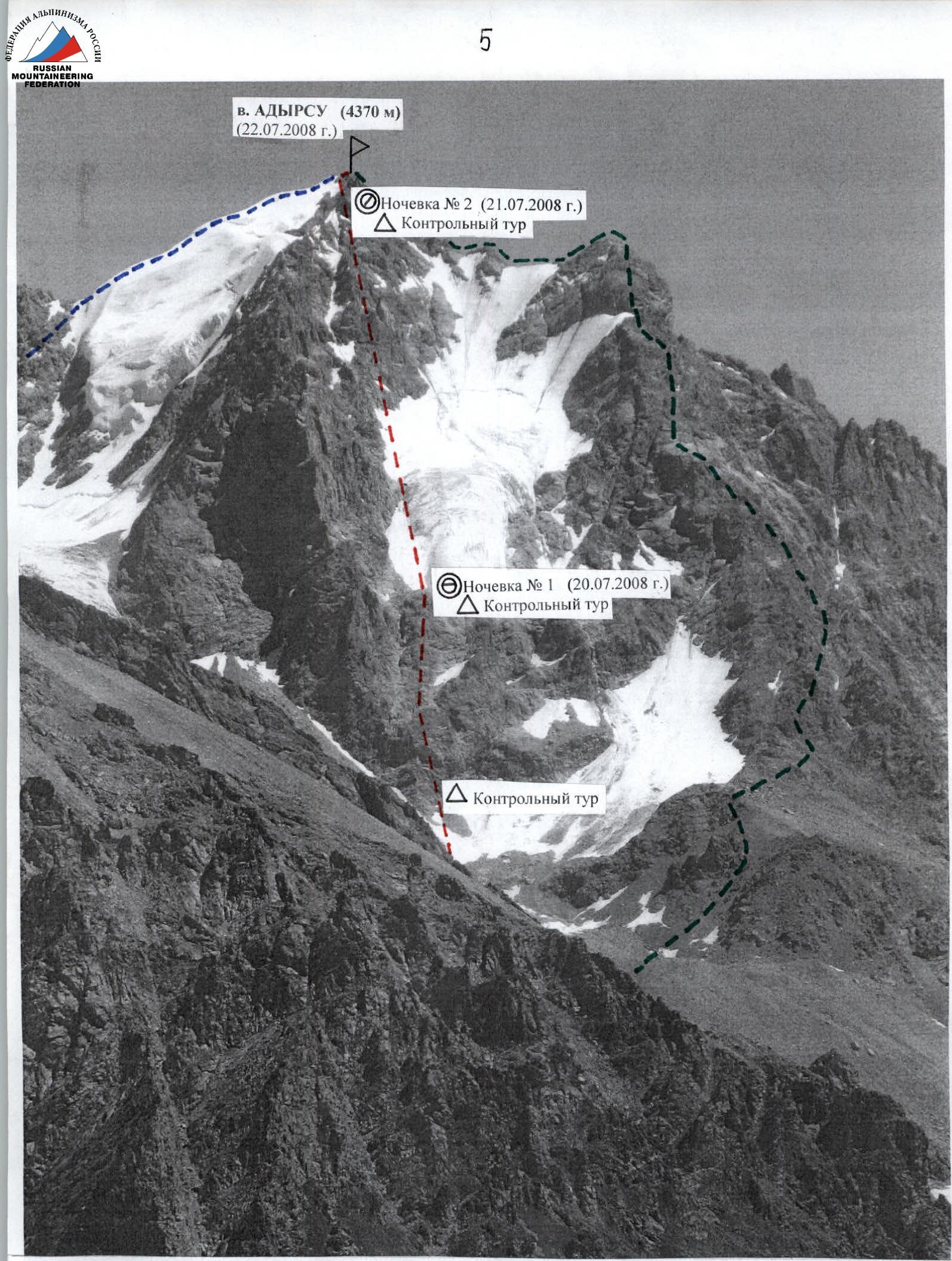
Photo 2. General view of the route
---3B category of difficulty route by D. KOKKINNA; --~5B category of difficulty route by THE TEAM; ---3A category of difficulty route by Vyal'tsev via the North-West ridge
First ascent via the South-West wall
via the North-West ridge
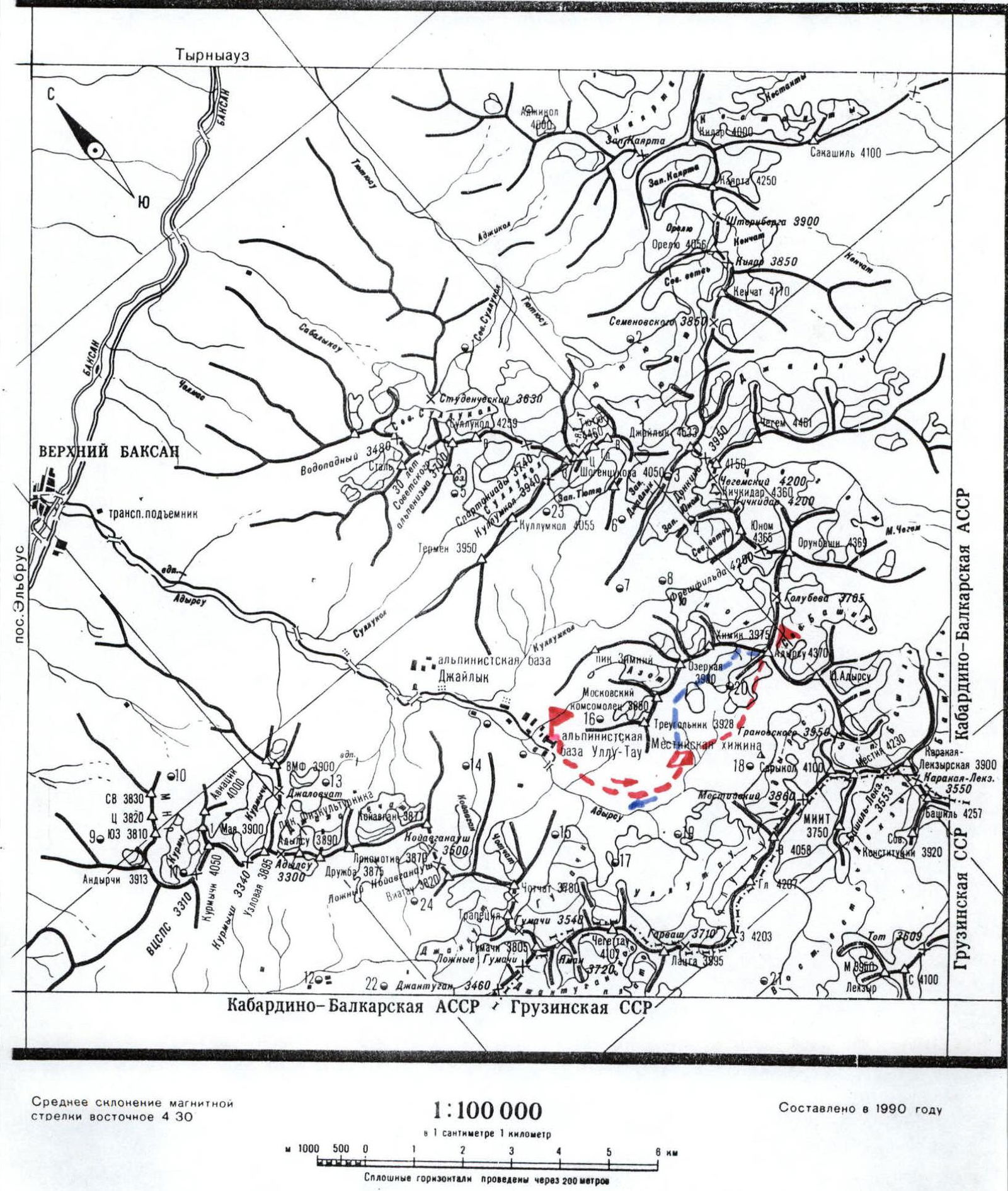
GOSKOMSPORT RSFSR UNION OF ALPINISTS Alpinist-Tourist Map
Conventions:
AUSB "Ullutau"
overnights near "Ryжие камни" (Red Rocks)
Peak Adyrsu
--- approach path
CENTRAL CAUCASUS - ADYRSU ~~~~~ return path
Brief overview of the climbing area and history of ascent to Adyrsu peak (4370 m)
The heavily branched Adyrsu Range branches off to the north from the nodal peak of the Main Caucasian Range — Sarikol, separating the Chegem gorge from the lateral gorges of the Baksan valley — Adyrsu, Tyutyusu, Sakashil. The range is a watershed of the Chegem and Baksan rivers.
Adyrsu peak (4370 m) — a nodal peak of the Adyrsu Range, is located between peak Sarikol behind the Granovsky Pass to the south and peak Orubashi behind the Golubev Pass to the north-east. Translated from the Balkar language, Adyrsu-Bashi means "steep mountain". The first ascent was made in 1896 by D. Kokkin via the North-West ridge.
According to the "Classification of Routes to Mountain Peaks" by the Russian Mountaineering Federation, 2001 edition, there are 6 routes to the Adyrsu-Bashi peak, including 3 training routes of 3A–3B category of difficulty (3 sports routes of 4A, 4B, 5A category of difficulty).
One of the most beautiful peaks in the gorge is very popular among climbers, with various routes available. In terms of technical difficulties, it is interesting for achieving 1st–2nd sports categories. When tactically preparing, it is necessary to consider this factor.
According to the ascent participants, the route taken by the team via the South-West wall through the central bastion can become quite popular among athletes when achieving the Candidate Master of Sports norm, as it is combined, fairly safe, and allows for a safe bivouac on rock ledges when passing the bastion.
Route scheme in symbols (UIAA), part 1
Route scheme in symbols (UIAA), part 2

Profile scheme of the route (without the ridge part) 1:2000

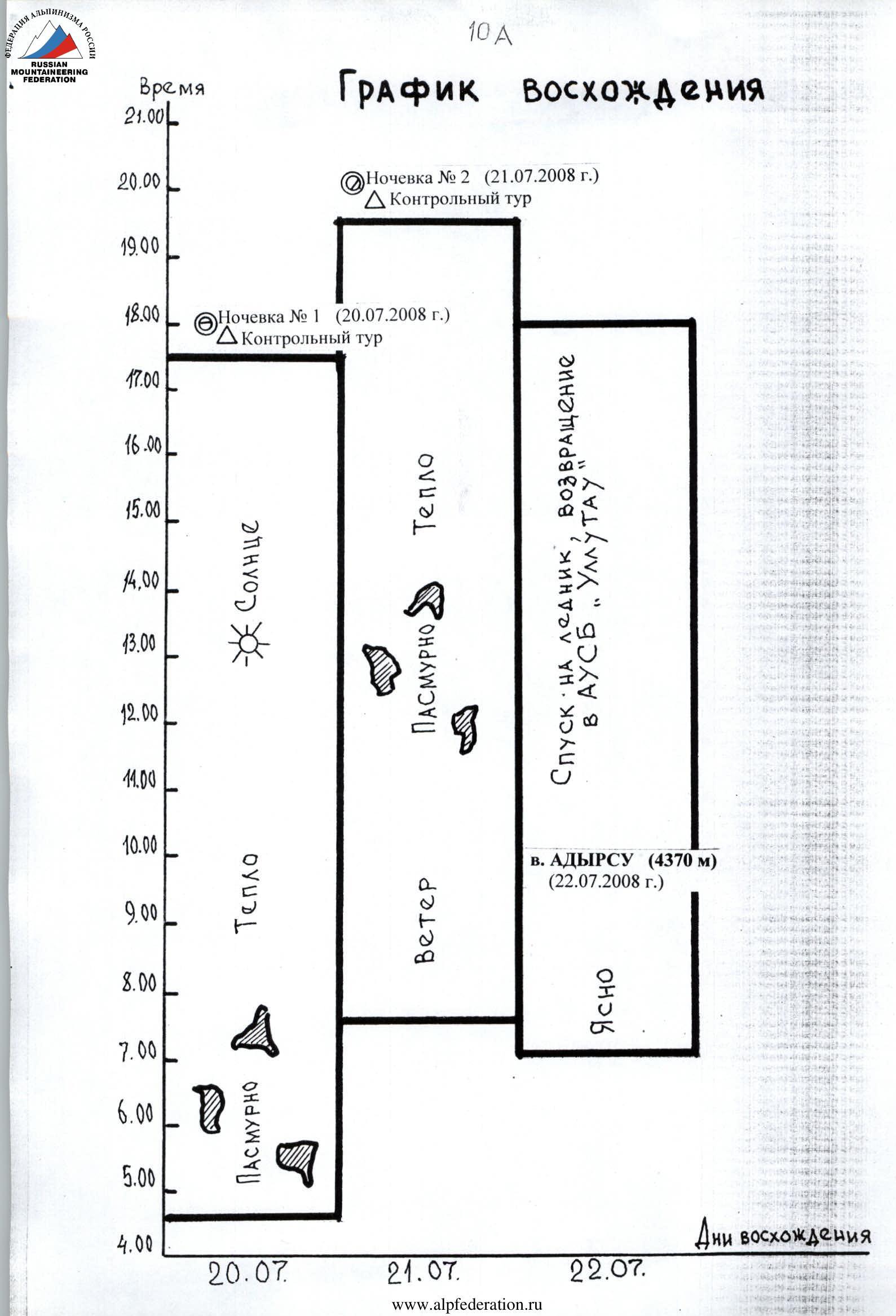
Ascent schedule
Tactical actions of the team
July 19, 2008.
At 10:00, the team left AUSB "Ullutau" and at 12:30 approached the overnight stay near "Ryжие камни" (Red Rocks), set up a bivouac. On the same day, a reconnaissance of the approach path to the lower part of the central bastion was conducted, and a visual inspection of the route options was carried out. The planned path passes through the center of the South-West wall of the bastion, between two couloirs with running water.
July 20, 2008.
At 4:30, the team left the bivouac and, after traversing the talus, reached a steep snow-ice slope to the beginning of the route at the lowest part of the bastion on a rocky ledge, where they set up the 1st control landmark to mark the start of the route. They linked up and began moving in a rope team: Bulocnikov – Monaenkov – Sandin. The first climber in the rope team moved in rock shoes on a double 50-meter rope with a lightened backpack.
Directly up the wall 40 m (45°, 4), left-up 30 m (55°, 5) to a rock ledge. From it, into an internal corner 35 m (65°, 5) to the next station, from which first right 20 m (90°, 5), and then on friction left to a passage between a rock cornice and an overhang to a good ledge, station. From it, directly up the wall 50 m (65°, 5) to a small ledge and another 50 m (55°, 5) to a large 15 x 7 m platform with an overhanging upper part. Under the overhang, a tent can be set up, water is scarce. Then, bypassing the overhanging part on the left and along an inclined slab 50 m (90°, V+), under the wall, difficult climbing. Then 40 m (60°, 5) to a good ledge, station. From the ledge 20 m (55°, 5) directly up the wall, and then difficult climbing 50 m (80°, V+) to the 2nd control landmark and the overnight stay location in a tent. From the overnight stay, a simple exit left 30 m (35°, 2) to the top of the bastion, and then to a snow-ice slope. At 17:30, they settled in for the night. 13 hours of work from the bivouac near "Ryжие камни".
July 21, 2008.
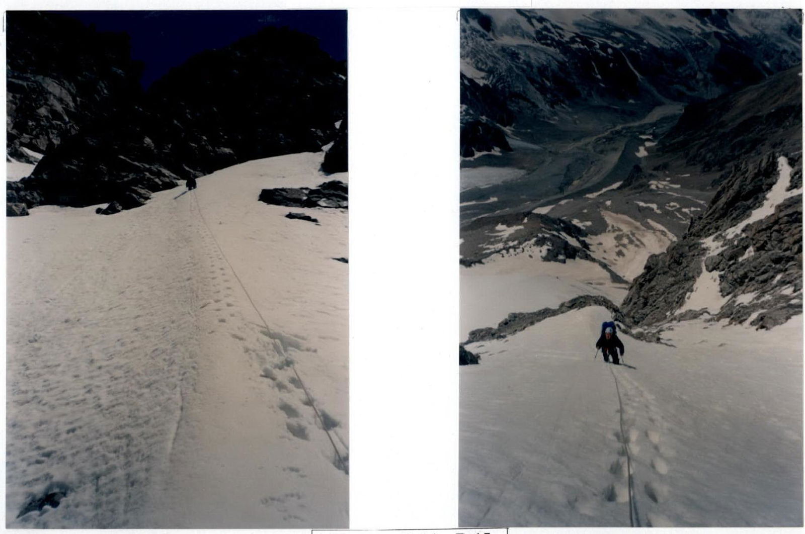
At 7:30, the team left the overnight stay on the bastion. The further path passes along a steep snow-ice slope 350 m (45–50°, 4), insurance via ice axes and ice screws. Movement upwards is carried out along the left part of the glacier, along the rock ridge. In the upper third, the ascent along the glacier passes through two glacier crevices filled with snow. Insurance.
The route along the snow-ice slope approaches under wet, destroyed rocks with indistinct, inclined ledges. Further up, along the destroyed rocks 50 m (55°, 5), station. From it, exit to a steep snow-ice ridge and ascent along it 50 m (45°, 4) to the base of a narrow couloir filled with snow and ice, which is crossed to the right 20 m towards an indistinctly expressed platform. From here, up a cleft 45 m (60°, 5) to a steep, smooth, vertical internal corner. Along it 15 m (90°, V+) to the rocks of the ridge part of the route 40 m (45°, 4). Along the rocks of the ridge, approach to a snow-ice "knife" and along it 80 m (35–40°, 4) to a large square stone, which is bypassed on the left, and then to the right under the overhanging rock of the Adyrsu summit ridge. At 19:30, the group organized a sitting overnight stay on a narrow ledge. A 3rd control landmark was set up here. 12 hours of work from the overnight stay on the bastion.
July 22, 2008.
At 7:00, the team began moving. From the overnight stay location, left 25 m along destroyed, snow-covered rocks, exit to the North-West ridge. Along the snowy ridge with a steepness of up to 35–40° (cornices) to approach the pre-summit ascent. Passing the bergschrund on the pre-summit ascent, exit to a simple short rocky ridge, along which they ascended to the Adyrsu summit, where they were at 9:30.
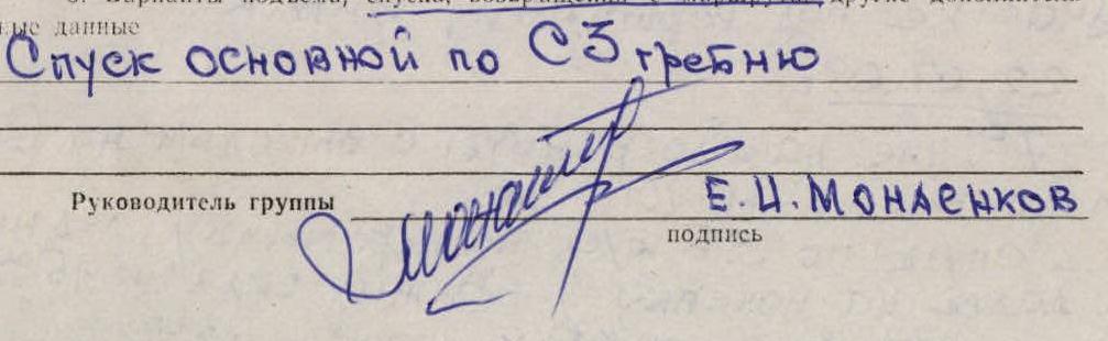
Descent from the summit along the 3B category of difficulty route via the North-West ridge (route by D. Kokkin) to a rocky saddle to a large gendarme. From the saddle 20 m down to the right to the first descent loop. Further, five oblique rappels to the right, 50 m each, descent to the glacier. Along the nameless glacier, following its right side, descended to the bivouac near "Ryжие камни". The descent took 4 hours 30 minutes. The team's return to AUSB "Ullutau" was at 18:00.
Conclusions and recommendations for the route
The route is fairly safe, with few "live" stones, and no spontaneous stone or ice falls were observed.
There are places for organizing a bivouac on the wall of the bastion on ledges where a platform can be laid out. The platform on top of the bastion (at the time of passage) is quite safe, as the small stones that have thawed out on the glacier go to the right and left into the stream beds. For an overnight stay by two people, a niche 1 m x 2 m with an overhanging upper part in the wall of this platform can be recommended.
In the second part of the route (after the bastion), when passing the ice section, there are no convenient places for an overnight stay. The location of the sitting overnight stay under the overhanging rock of the pre-summit ridge is recommended for organizing a bivouac by subsequent groups. If you exit late onto the North-West ridge and need to overnight, there is a possibility of organizing it 50 meters below along the ridge:
- 50 meters below along the ridge
- in a hollow
It is recommended to pass the route in the first half of the summer season. Additionally, it is necessary to consider the presence of groups ascending along the pre-summit North-West ridge (3B) and South-West ridge (3A), as falling stones can fly directly along the ascent path along the glacier. Possible stone thawing and falling along the glacier in the second half of the day makes the ascent problematic and dangerous. Exit to the glacier — no later than 6–7 am.
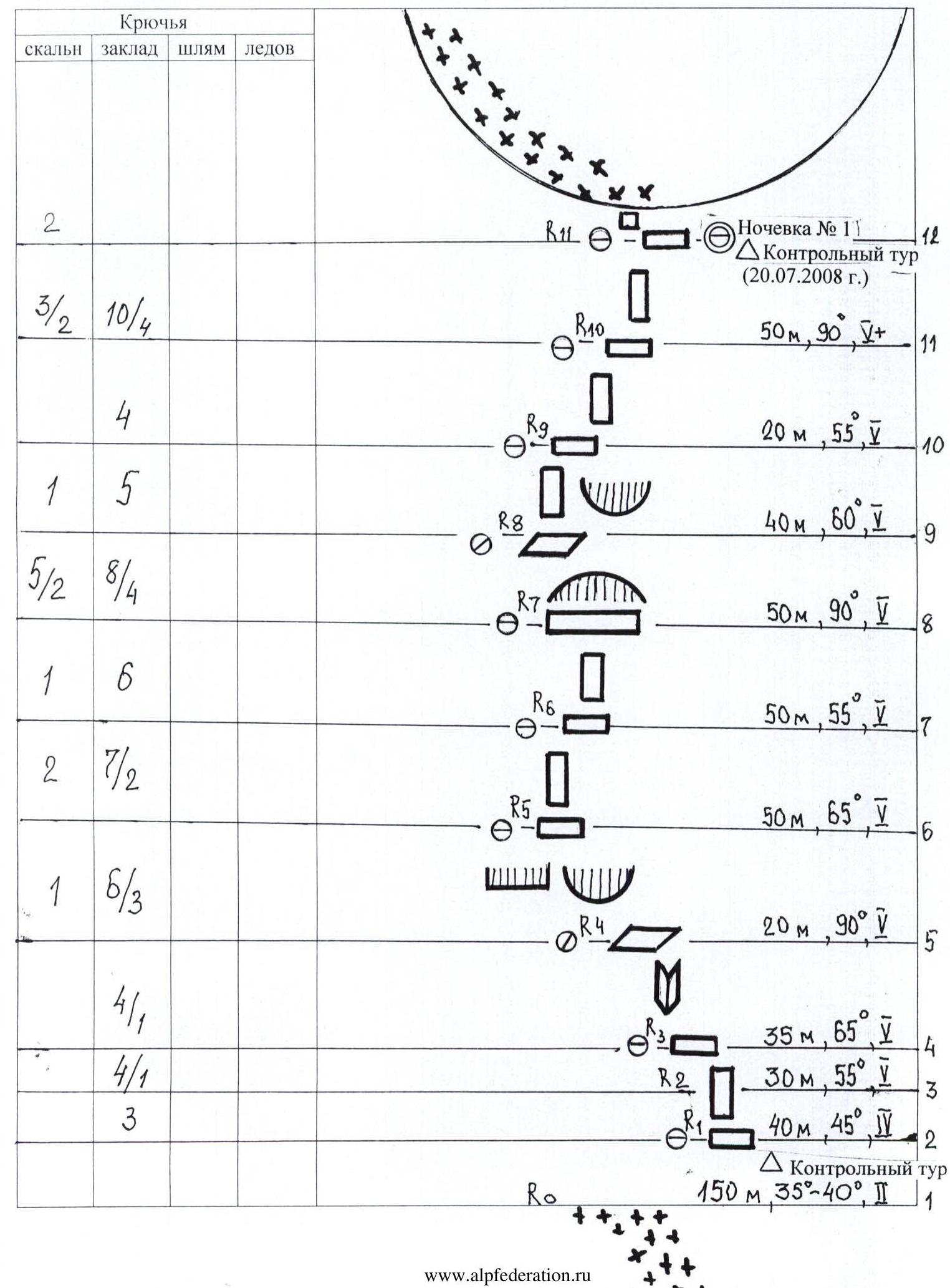
Route description by sections
| Section | Description |
|---|---|
| R0–R1 | 150 m 35–40° 2 category of difficulty from the moraine to the lower part of the bastion along a steep snow-ice slope to a ledge. 1st control landmark. |
| R1–R2 | 40 m 45° 4 category of difficulty directly up the wall. |
| R2–R3 | Left-up along rocks 30 m 55° 5 category of difficulty to a ledge. |
| R3–R4 | From the ledge, ascent along an internal corner 35 m 65° 5 category of difficulty to the next station. |
| R4–R5 | Ascent to the right-up 20 m 90° V+, then left on friction to a passage between a cornice and an overhang. |
| R5–R6 | 50 m 65° 5 category of difficulty along the wall to the next station. |
| R6–R7 | 50 m 55° 5 category of difficulty to a large ledge 15 x 17 m. |
| R7–R8 | Bypass the overhang on the left and along an inclined slab 50 m 90° V+ under the wall, difficult climbing. |
| R8–R9 | Ascent along the wall to a good ledge 40 m 60° 5 category of difficulty. |
| R9–R10 | From the ledge up along the wall 20 m 55° 5 category of difficulty. |
| R10–R11 | Difficult climbing 50 m 90° V+ to the overnight stay location. First overnight stay (July 20, 2008). 2nd control landmark. |
| R11–R12 | From the overnight stay location, exit left 30 m 35° 2 category of difficulty to the top of the bastion to a snow-ice slope. |
| R12–R13 | Along the snow-ice slope 350 m 45–50° 4 category of difficulty to approach under wet, destroyed rocks. |
| R13–R14 | Along destroyed rocks 50 m 55° 5 category of difficulty to a snow-ice ridge. |
| R14–R15 | Along the snowy ridge 50 m 45° 3 category of difficulty to the beginning of a narrow couloir filled with snow and ice. Cross the couloir to the right 20 m. |
| R15–R16 | Up a cleft 45 m 60° 5 category of difficulty to an internal corner. |
| R16–R17 | Along a steep internal corner 15 m 90° V+ to the rocks of the ridge part of the route. |
| R17–R18 | Along the rocky ridge to approach a snow-ice "knife" 40 m 45–50° 4 category of difficulty. |
| R18–R19 | Along the snowy "knife" 80 m 35–40° 3 category of difficulty to a large square stone, bypass it on the left and to the right under the overhanging rock. Second overnight stay (July 21, 2008). 3rd control landmark. |
| R19–R20 | From the overnight stay location, left along destroyed rocks 25 m 3 category of difficulty to exit to the North-West ridge. Along the snowy ridge 35–40° (cornices) to approach the pre-summit ascent. Passing the bergschrund, exit to a simple rocky ridge and along it to the Adyrsu summit. |
Descent from the summit along the 3B category of difficulty route via the North-West ridge (route by D. Kokkin).
Photo illustrations of the report — 1
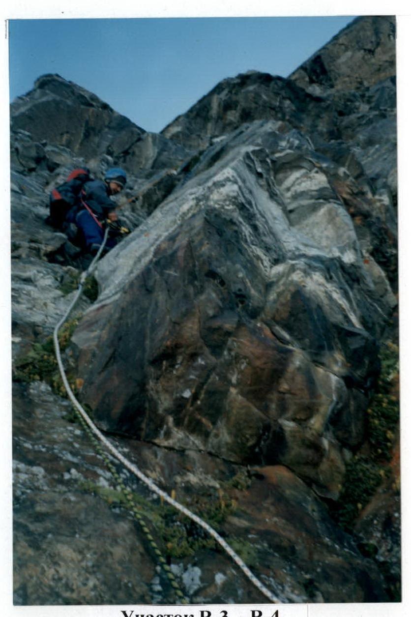
Section R3–R4
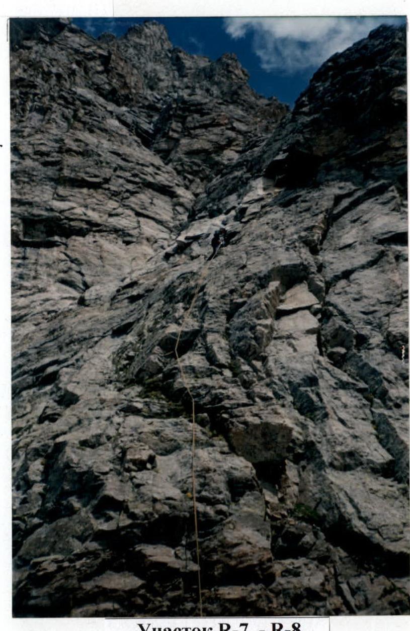
Section R7–R8
Section R3–R4
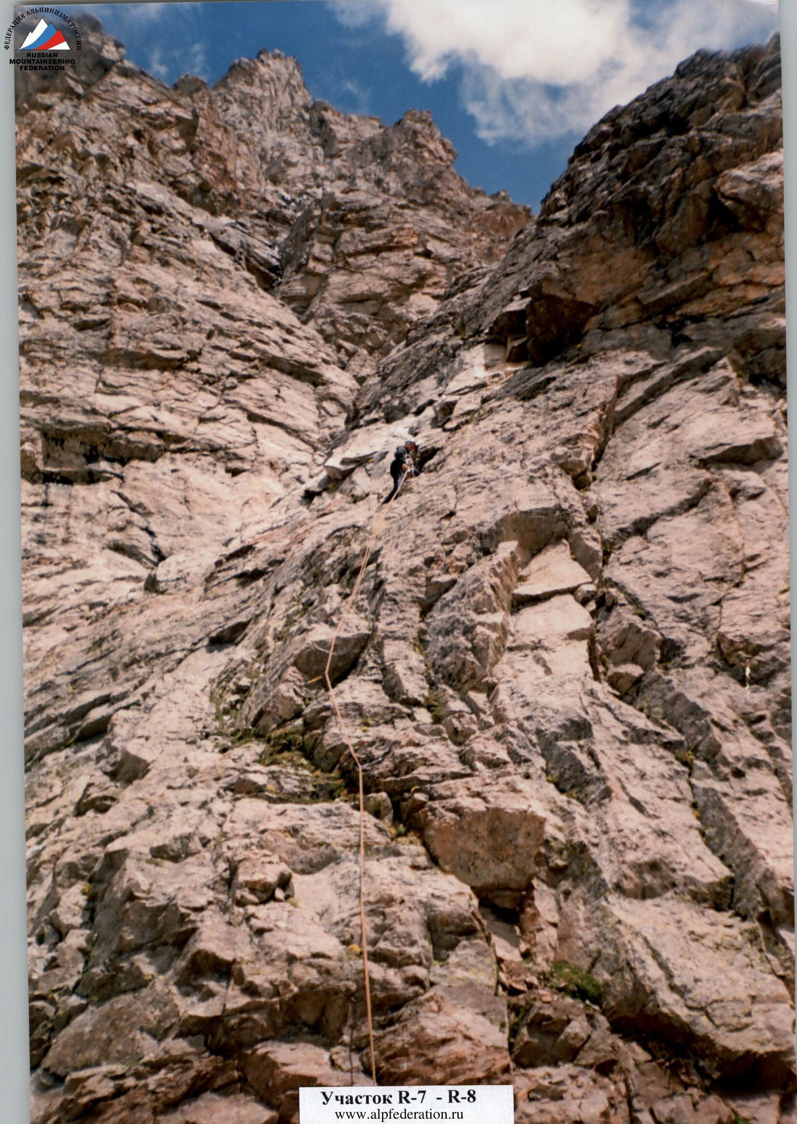
Section R7–R8
Photo illustrations of the report — 2

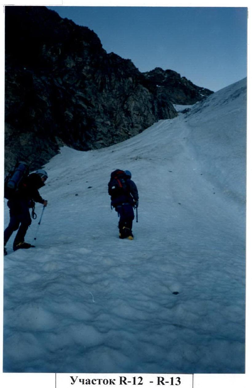
Photo illustrations of the report — 3
Section R14–R15
Photo illustrations of the report — 4
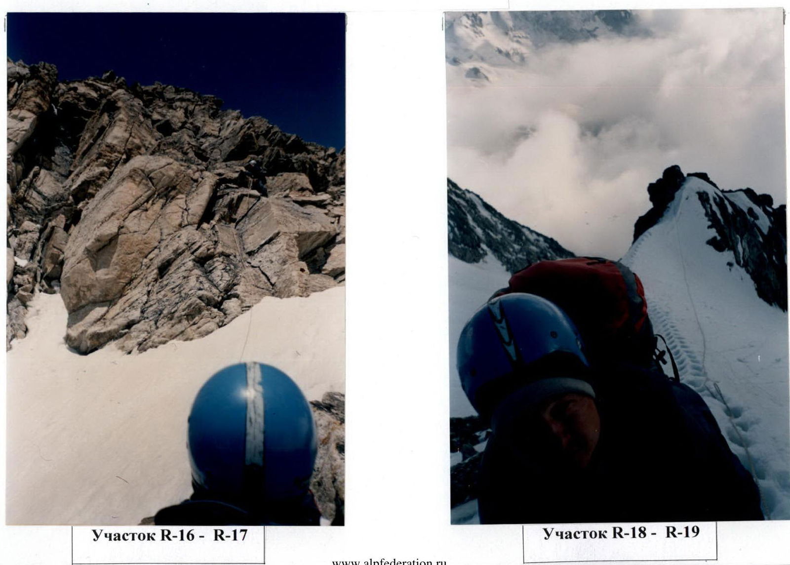
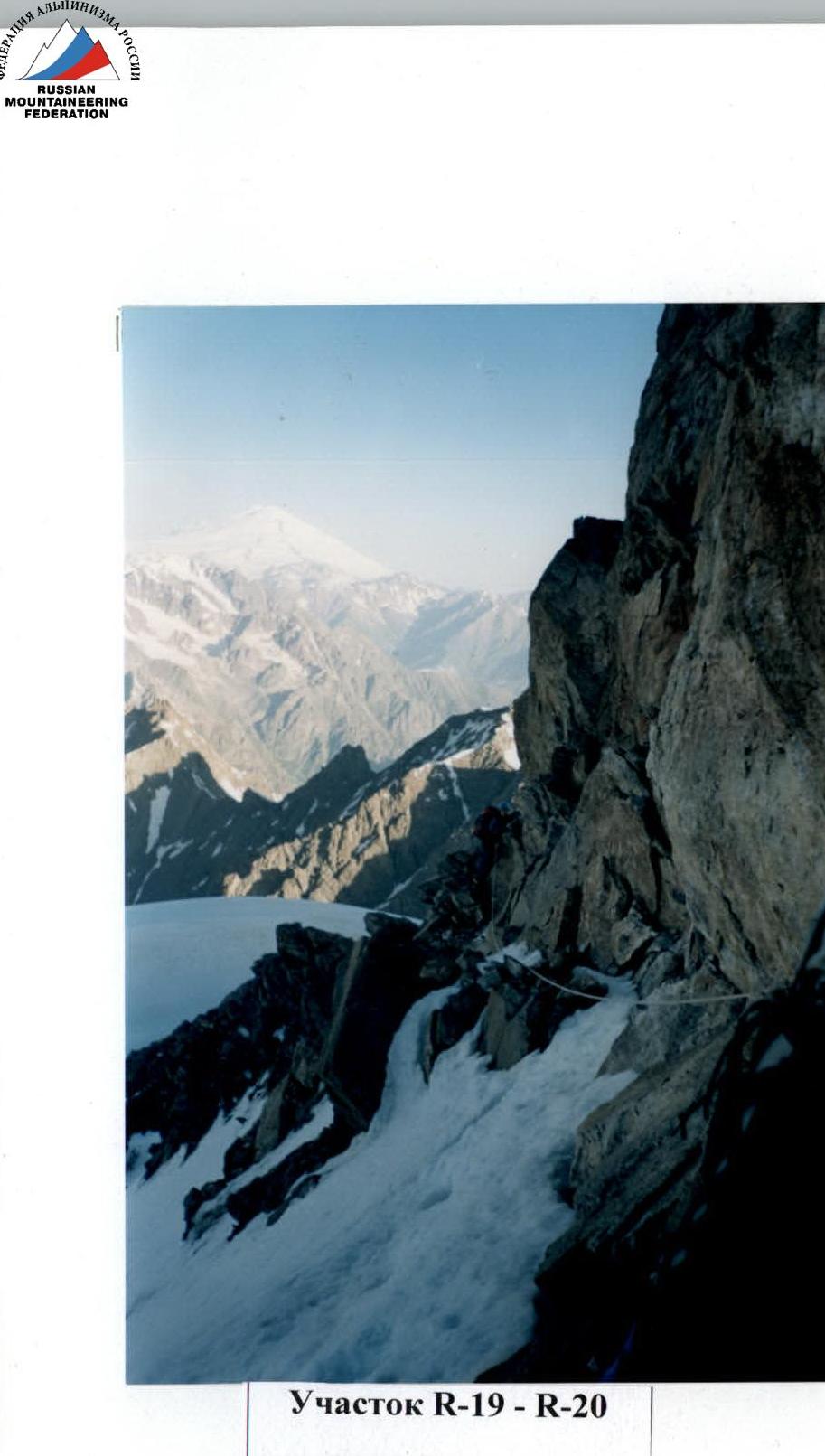
Photo illustrations of the report — 5
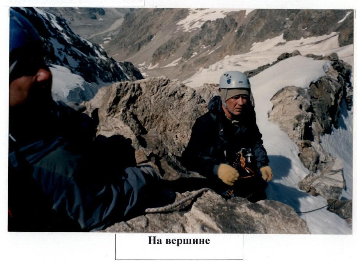
On the summit
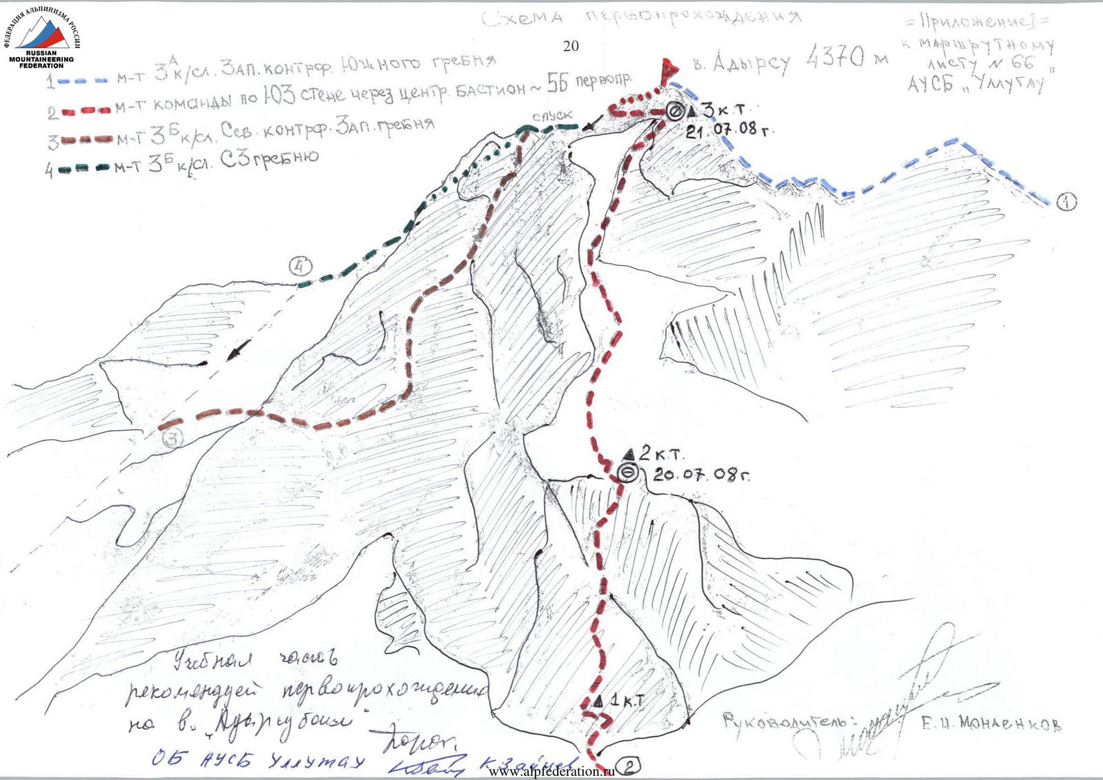
First ascent scheme
route 3 category of difficulty along the West counterfort of the South ridge
team's route via the South-West wall through the central BASTION 5B first ascent
route 3B category of difficulty along the North counterfort of the West ridge
route 3B category of difficulty along the North-West ridge
Peak Adyrsu 4370 m
= Appendix 1 =
to route sheet
No. 66
AUSB "Ullutau"
3 Control Landmark
July 21, 2008
descent
Training part
we recommend the first ascent
to peak Adyrsu-Bashi Porokhnya
about AUSB Ullutau Kab. Balkaria
2 Control Landmark
July 20, 2008
1 Control Landmark
Leader: E.I. Monaenkov

Route sheet No. 66
a) standard, additional, special equipment:
- main rope 50x3
- auxiliary rope 15 m
- carabiners 15
- ice axes 1
- ice axes 2
- rock hammers 1
- ice hammers 1
- rock pitons 15
- ice pitons 5
- crampons 3
- harness, rope attachment 3
- chocks 10
- descent loops 8
- self-insurance loops 3
- extension loops 2
- box, wedges 8
b) bivouac equipment, clothing, first aid kit:
- personal equipment for 3 people
- down sleeping bag "NOGA" 2
- down jacket 3
- protective helmets 3
- matches LIGHTER
- candles
- lightweight tent 1
- tent-bag
- rain poncho 2
- stove TORELKA 1
- gas, l. 16
- pots 2
- flashlights 3
- flares
- flare guns
c) communication, signaling means:
- radio station (type) TOK-17
- radio station power supply set.
d) food supply: for 3 people for 3 days
- Plan of interaction, communication schedule, and signaling with the base camp and other groups
communication time: 9:30, 12:00, 14:30, 18:30, 21:00
FEDERATION OF ALPINISM OF RUSSIA ROUTE SHEET No. 66 (Compiled in two copies) For the ascent (hike) First ascent to peak Adyrsu via the South-West wall through the BASTION cat. diff. approx. 5B along the route led by MONAENKOV E.I. consisting of 3 people. from July 19 to July 22, 2008. Ascent organized by AUSB "Ullutau" specify event Group departure is agreed upon, permitted by Porokhnya and 31 Date July 16, 2008 position and signature of the person responsible for the release Group registered with KSP, rescue team
Control deadline for return to Ullutau appointed on July 23, 2008 at 18:00 signature
Departure agreed upon with KSP of the region signature of KSP officer
Group returned from the route on July 22, 2008 at 19:00, having completed the ascent (hike) in: full composition full, incomplete, f., i., o. those who did not complete the ascent
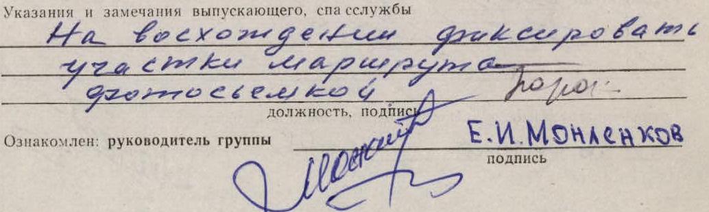
Instructions and comments from the releasing officer, rescue service
During the ascent, fix
route sections
route filming Porokhnya
position, signature
Informed: team leader E.I. Monaenkov
signature

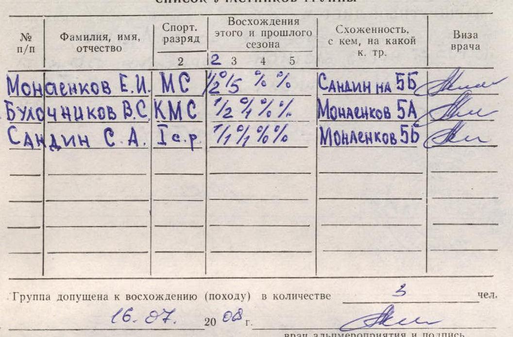
List of team participants
| No. | Surname, name, patronymic | Sports category | Ascents this and previous season | Cohesion, with whom, on what category of difficulty | Doctor's visa |
|---|---|---|---|---|---|
| 1. | Monaenkov E.I. | MS | 2/5 % % | Sandin on 5B | |
| 2. | Bulocnikov V.S. | CMS | 1/2 % % % | Monaenkov 5A | |
| 3. | Sandin S.A. | 1st sports cat. | 7/19/%/% | Monaenkov 5B |
When preparing for the ascent, the group used materials from the conducted reconnaissance, KSP card index, or camp, manuals, and received consultation (from whom)
We, the leader and participants of the group, know the "Rules for Conducting Alpine Events in the USSR", safety rules for mountaineering, and take full responsibility for their compliance during the ascent.
Tactical plan of ascent, time allocation, route sections, and other
SCHEME
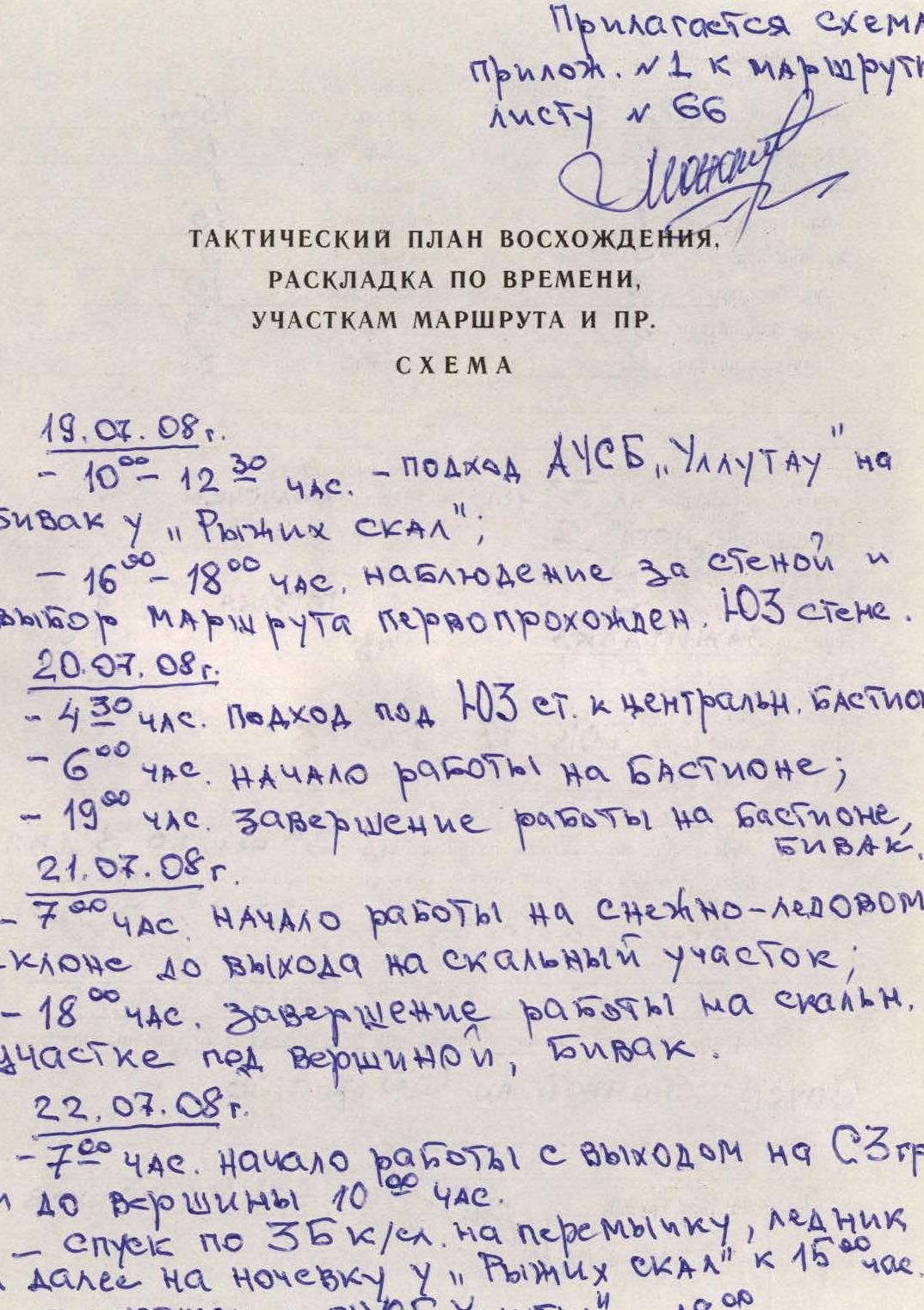
July 19, 2008.
- 10:00–12:30 – Approach from AUSB "Ullutau" to the bivouac near "Ryжие скалы" (Red Rocks);
- 16:00–18:00 – Observation of the wall and selection of the first ascent route via the South-West wall.
July 20, 2008.
- 4:30 – Approach under the South-West wall to the central bastion;
- 6:00 – Start of work on the bastion;
- 19:00 – Completion of work on the bastion, bivouac.
July 21, 2008.
- 7:00 – Start of work on the snow-ice slope until exiting to the rocky section;
- 18:00 – Completion of work on the rocky section under the summit, bivouac.
July 22, 2008.
- 7:00 – Start of work with exit to the North-West ridge and to the summit by 10:00.
- Descent via the 3B category of difficulty route to the saddle, glacier, and further to the overnight stay near "Ryжие скалы" (Red Rocks) by 15:00.
- Return to AUSB "Ullutau" by 18:00.
As soon as my eyelids open wide – I'm captivated by the right, The star of the gorge – ULLU-TAU – calls to the window with persistence
I'll see the mighty rise of the rocks, The dawn that lit the slopes… With what grandeur it awaits Those who have not yet conquered!
KABARDINO-BALKARIA
AUSB
ULLU-TAU