- preliminary
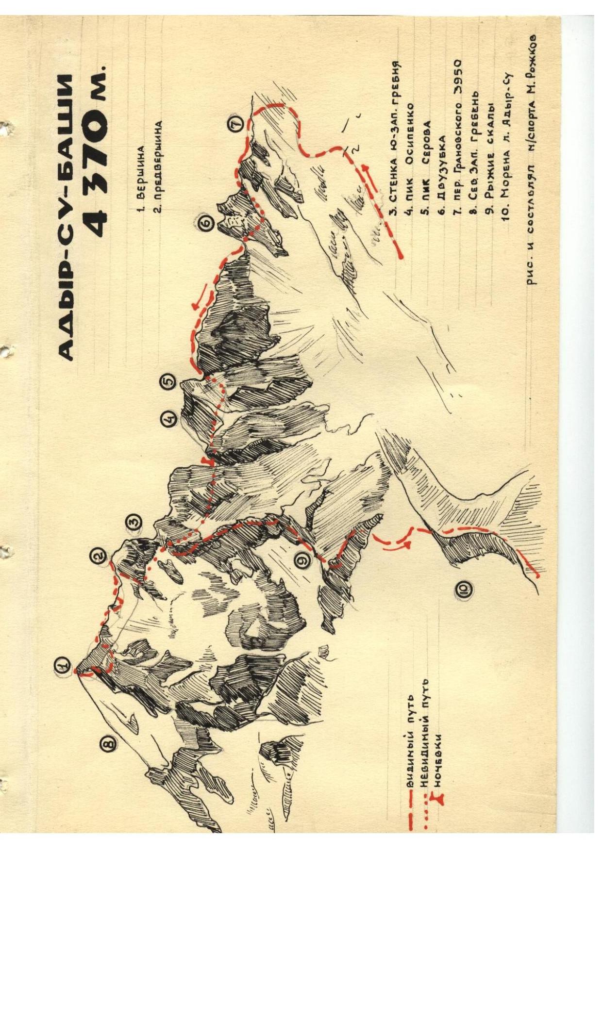
The summit of Adyr-Su-bashi, category 4A, via the Granovskiy Pass, elevation 4370 m. The nature of the route is predominantly rocky and icy.
The summit of Adyr-Su-bashi is located in the northern Adyr ridge of the Main Caucasian Range.
Several ridges lead to the summit, including the southern one, descending to the Granovskiy Pass.
Day 1
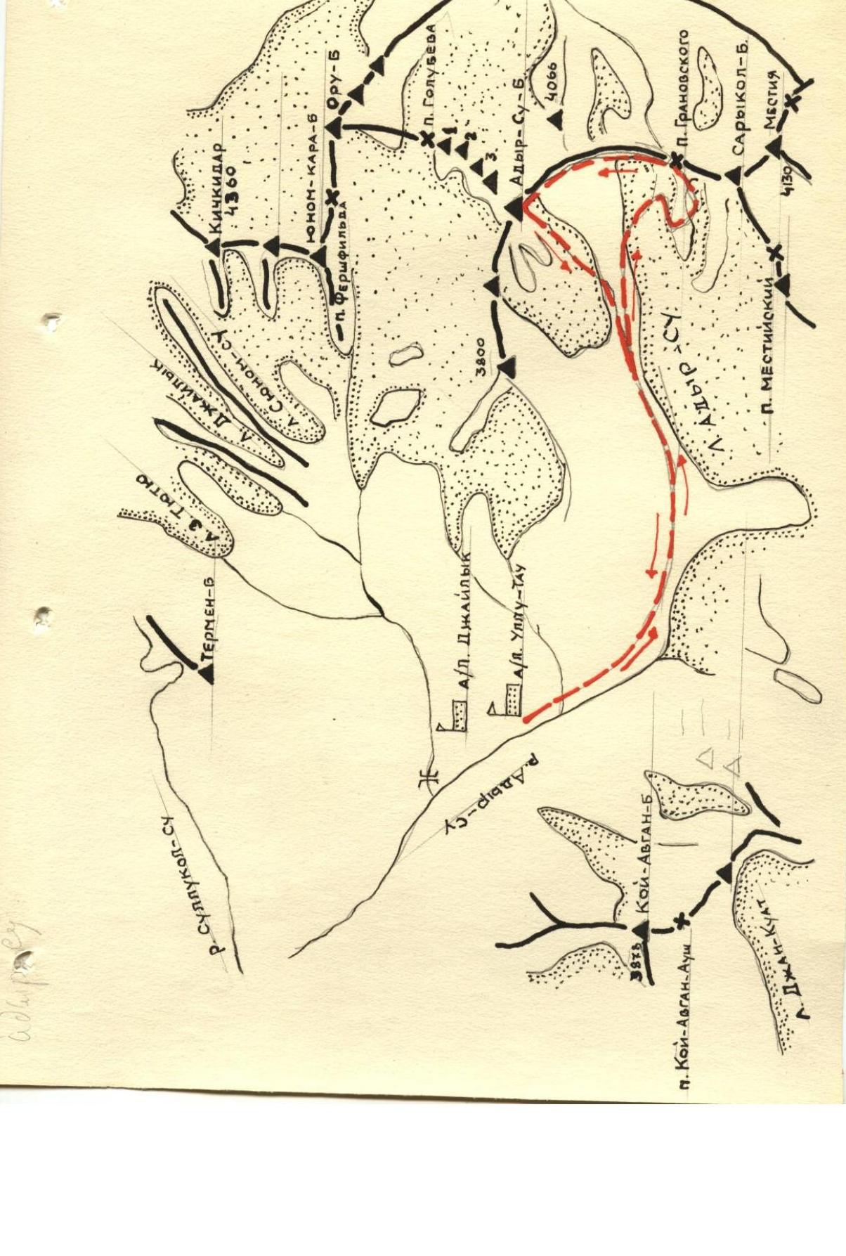
Approaches to the Granovskiy Pass are made:
- via the Mestia trail,
- then along the left-bank moraine of the Adyr-Su glacier.
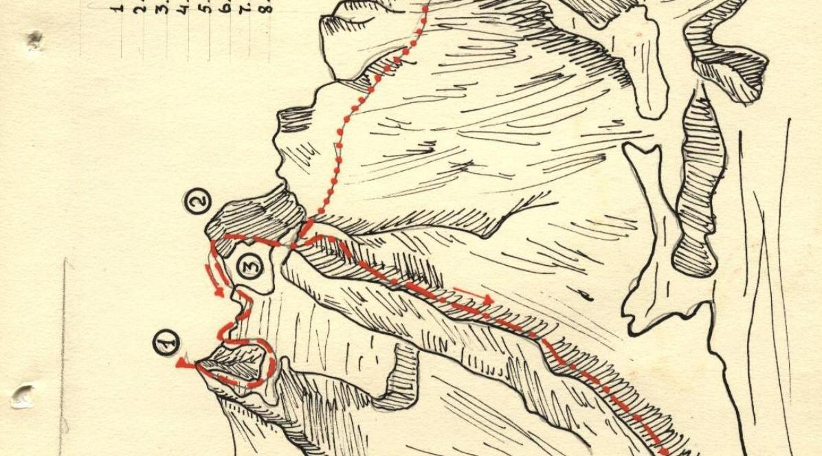
Having passed the moraine almost to its beginning, turn right onto the Adyr-Su glacier. On the glacier, head east-southeast, keeping direction towards the double-peaked tower rising on the eastern ridge of Adyr-Su-bashi, slightly to the left (in the direction of travel) of the pass.
Having traversed the lower part of the glacier, approach the icefall located to the left of the rocks that bound the counterfort descending from the eastern ridge. The icefall is bypassed on the left.
After the icefall, turn right towards a snow saddle that is weakly expressed in the aforementioned counterfort. The ascent to the saddle is made along a snow slope with a basal crevasse having a steepness of 30°.
Having reached the saddle, turn left and ascend along a fairly broad and gentle snow slope to the Granovskiy Pass, where a night's stay is organized.
The journey from the camp to the pass takes 5.5–6 hours.
Day 2
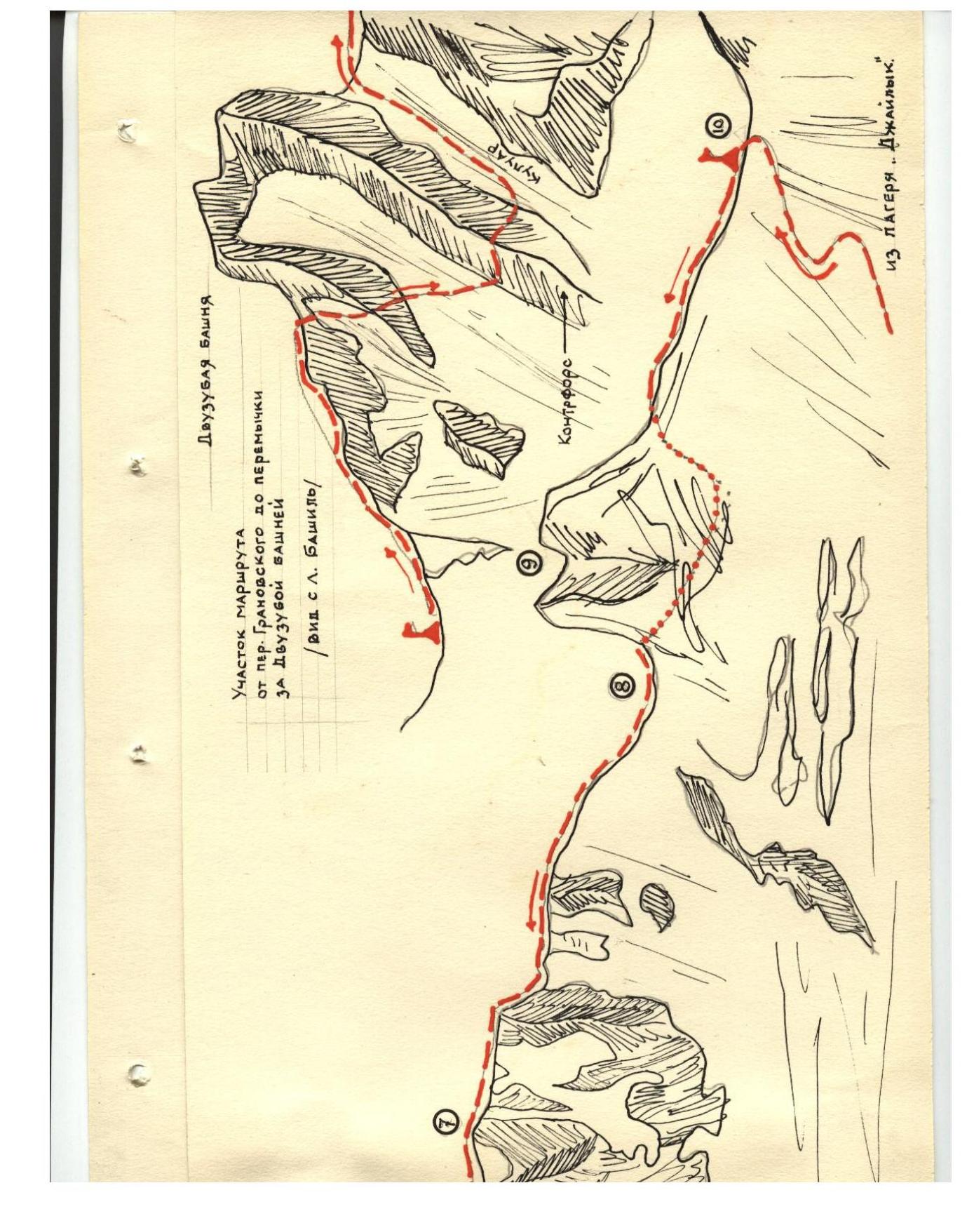
From the pass, turn left and proceed along the broken simple rocks of the eastern ridge, keeping to the left slopes of the ridge.
Thus, reach the saddle before the double-peaked tower, which is 1–1.5 hours' journey from the pass.
The double-peaked tower on the right as seen from the Bashil glacier.
To bypass the double-peaked tower, it is necessary to:
- descend downwards,
- then traverse the rocky slope to the left, crossing the counterfort descending from the double-peaked tower,
- enter a couloir and ascend along it to the saddle at the double-peaked tower.
Here is a suitable location for a night's stay.
From this saddle, proceed to the left of the ridge line towards the tower where the control point is located. The rocks are quite challenging. Careful belaying is required.
From this tower, proceed along the right side of the ridge, i.e., bypass a series of "mandarins" present in the ridge after the tower.
After 3 hours of travel, approach a point where the ridge drops sharply by 70–80 m.
The descent to the saddle is made along the ledges on the left slopes of the ridge and partially by rope. From the saddle, it is again necessary to descend by rope 35–40 m to a characteristic protrusion resembling a "sheep's forehead." From this protrusion, descend another 15–20 m to a steep snow slope, which is traversed, and then ascend onto rocks, and subsequently onto a counterfort, along which one ascends back onto the ridge.
From the ridge, make an ascent to Serov Peak. Having returned to the point of ascent onto the ridge, continue to ascend along it until a steep rise. Here, turn right and ascend to Osipenko Peak.
After Osipenko Peak, the ridge drops sharply by 100–120 m. Proceed along the ridge, bypassing "gendarmerie" peaks from the eastern side. The point of the ridge's lowering is the Serov Pass.
Day 3
From Serov Pass, proceed along the snow slope to the right of the ridge, keeping direction towards two large couloirs descending from the upper part of the Adyr-Su massif. Crossing the left couloir in its lower part, ascend along the right couloir beneath the wall of the southeast ridge. The wall is overcome with piton belays, after which one ascends to the preliminary summit and along the preliminary summit's southeast ridge ascends to the summit of Adyr-Su.
The descent from the summit is made via the route of category 3A.
Time calculation:
- Camp — Granovskiy Pass — 5–6 hours
- Granovskiy Pass — Serov Peak — 6–7 hours
- Serov Peak — Serov Pass — 3–4 hours
- Serov Pass — summit — 3–4 hours
- Summit — camp — 5–6 hours
Total: 26–27 hours
| :-- | :-- |
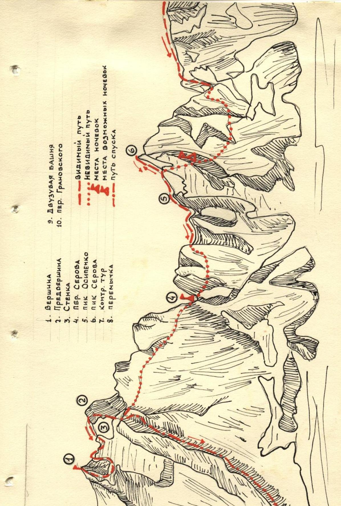
- Preliminary summit
- Wall
- Serov Pass
- Ostapenko Peak
- Serov Peak
- Control point
- Saddle