AADIP-CY-5ALUU 4370 m
3. Route Description
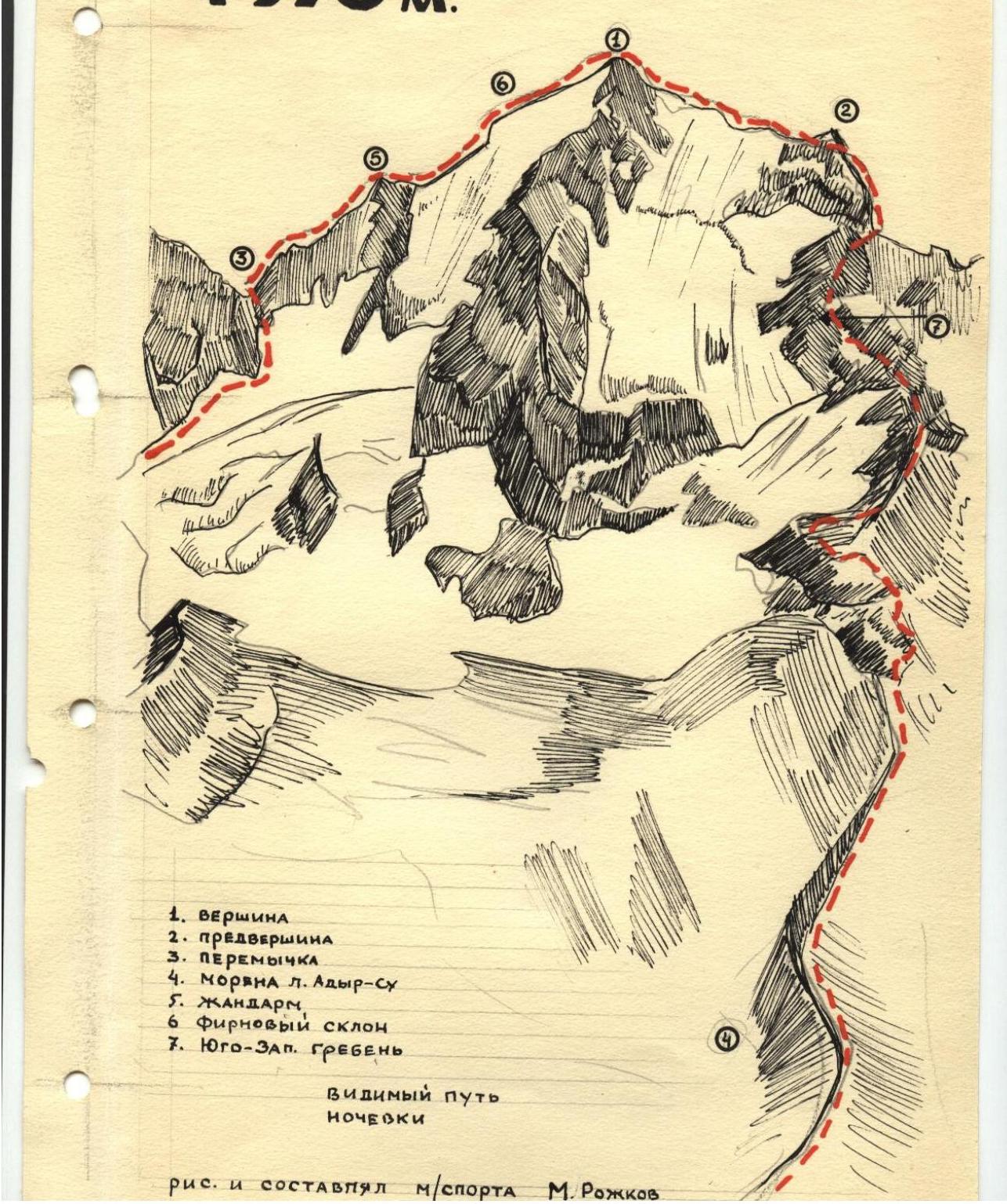
Route of ascent to the summit ALYR-SU-BASHI via the northwest ridge (4370 m) Route category 3B
The summit ALYR-SU-BASHI is located in the northern Alyr spur of the Main Caucasian Range, between the Goudunov and Granovsky passes. Three ridges radiate from the summit:
- to the North
- to the Northwest
- to the South
A counterforce extends eastward to the Bashdy glacier.
We leave the "Udu-Tau" tourist camp at 4 pm. The path to the overnight stay lies along the Shestyiskaya trail, which leads to the right-bank moraine of the Alyr-Su glacier. Before reaching the "rusty fences" on the left, we descend from the moraine to the base of the terminal moraine of the unnamed glacier and ascend to the "large rocks".
From the "large rocks":
- we proceed along the terminal moraine to the right-bank moraine of the unnamed glacier,
- reach the tower of the Azot peak spur,
- bypass it on the right via a convenient ledge with reliable outcrops for belay organization,
- and simultaneously move forward to reach the snowy plateau.
We cross the plateau in the left part of the route, following the edge, and reach the beginning of the snowy couloir leading to the saddle between the summits of Alyr-Su-Bashi and Khimik. The couloir is 10-12 m wide, 3-4 rope lengths long, and has a slope of 40-45°.
On the way from the saddle, we initially encounter three "gendarmerie" rock formations, the first of which is taken "head-on". The next two are bypassed on the right via ledges.
The rocks are relatively intact, with convenient outcrops for belaying.
Immediately after the third "gendarme", a snowy-ice ridge begins, stretching 2-3 rope lengths with a slope of 45-50°.
If there is snow on the ridge, it is traversed with thorough belaying using ice axes, and only in the upper part, where there is regelation ice with a thin layer of snow, an ice screw is used. Otherwise, the entire ridge is traversed with piton belaying. Further ascent to the tower of the first summit and descent from it are done via easy, monolithic rocks with good outcrops and holds, leading to a snowy ridge. The ridge is initially gentle, becoming steeper, and near the pre-summit rise, it reaches 35-40°. One should be cautious of overhanging cornices on the leeward side, moving 8-10 m below the visible edge of the ridge. The snowy field represents a system of rises. Before the summit, it is intersected by a wide bergschrund, which must be bypassed by deviating to the right. Then, we pass a small snowy ridge and reach the summit via rocks.
The descent is conducted via the WGS - the western ridge of the Akhyr-Su summit (category 3 difficulty).
We return from the summit, descending 10 m, and begin the descent into the couloir, moving with piton belaying for 2-3 rope lengths. Then, we exit onto the ridge. The ridge leads to the pre-summit, which we bypass on the left upwards. Further, pure rocks lead to a small slab. Here, we organize a rappel, descending a 20-25 m wall. Under the wall lies a snowy depression and, to the left, a characteristic "rusty" talus.
Further movement:
- From the depression, logical movement is downwards along the slope of the couloirs, orienting towards the "rusty rocks"
- At the end of the descent - ice until the rusty rocks
- We turn left downwards and exit onto the right-bank moraine of the Akhyr-Su glacier
- Further along the moraine and local trail to the camp.
Recommendations for climbers:
- Initial bivouac at the "large rocks"
- Time of departure for the bivouac is 3:00 am.
- Special equipment for a group of 4 people: a) 2×30 m main rope, b) 4-6 rock pitons, c) 4-6 ice screws, d) 2 hammers, e) 8 carabiners.
- Possible bivouac locations: a) on the saddle between the "Khimik" and Akhyr-Su-Bashi summits, b) in the depression after the wall.