Report
on traversing 1st, 2nd Western — Eastern peaks of Trezubets 2B category of the team led by Popov V.I.
I. Climbing Passport
| 1. General Information | ||
|---|---|---|
| Full Name, sports rank of the leader | Samofeeva, CMS. | |
| Full Name, sports rank of participants | Bondarenko A.Yu., Plotnikov I.I., Simonov P.A., Strizhko A.S., no rank. | |
| Full Name of coach | Popov V.I. | |
| 2. Characteristics of the climbing object | ||
| Region | From Nakhar pass to Chiperezau pass | |
| Valley | Cirque krugozor Myrd | |
| Name and height of the peak | Trezubets traverse 3-V (1st Western, 2nd Western, Eastern) | |
| 3. Characteristics of the route | ||
| Name of the route | Trezubets traverse 3B | |
| Category of complexity | 2B | |
| Degree of route development | Often chosen by climbers | |
| Relief characteristics of the route | Rocky | |
| Descent from the peak | From the Eastern peak along the ascent route to the descent couloir; further to the grassy slope and to the ascent path. | |
| 4. Characteristics of the team's actions | ||
| Time of movement (team's working hours, indicated in hours and days) | 7.5 hours | |
| Exit to the route | 7:00 | |
| Reach the peak | 11:30 | |
| Return to the base | 13:00 | |
| camp | ||
| :-- | :-- | :-- |
| Full Name | Bondarenko A.Yu., Strizhko A.S. |
General view
of the route.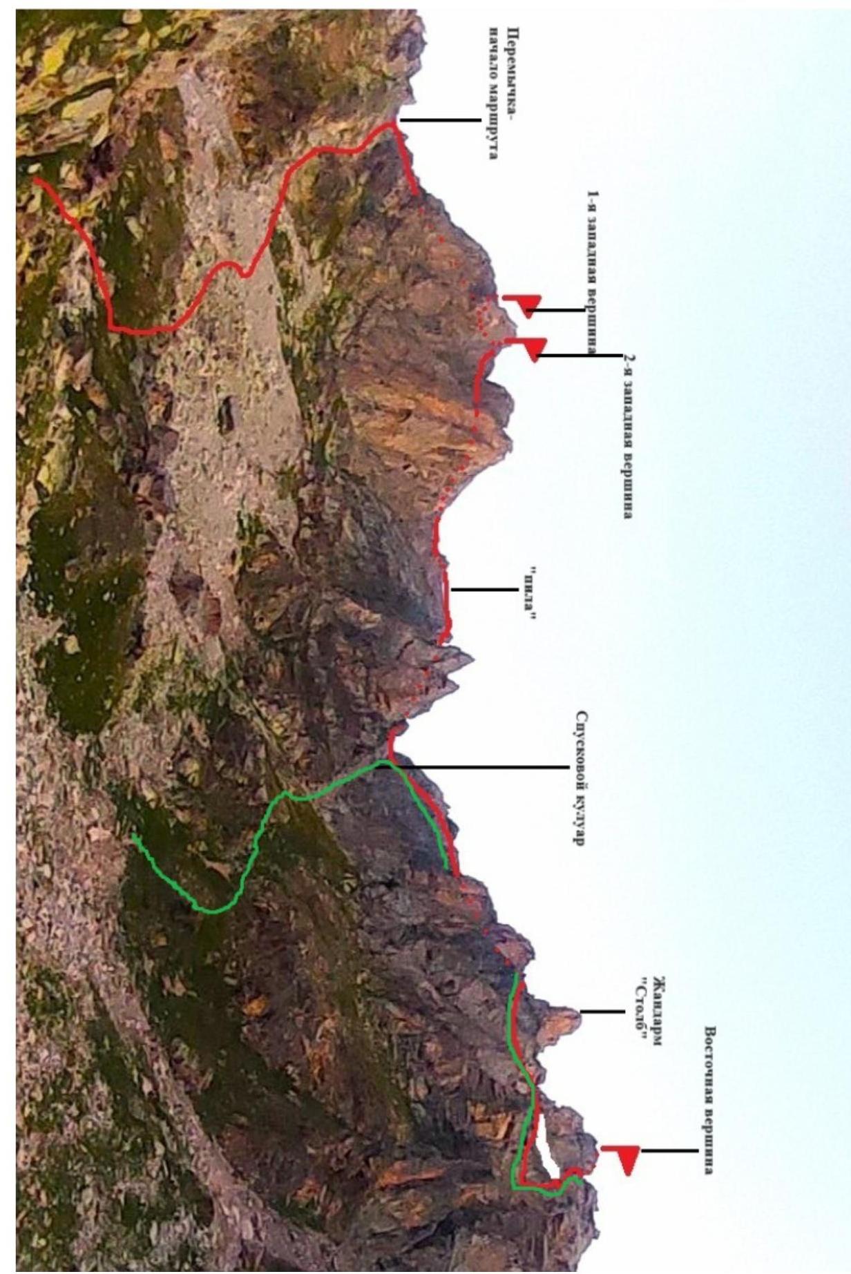
Scheme
UIAA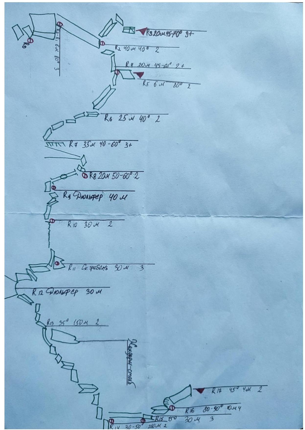
Route description
| Section number | Description | Photo number |
|---|---|---|
| Start of the route | From the bivouac under Trezubets, ascend the scree slope, then the couloir with gray scree to the saddle (in the eastern direction). Look up at the slopes: touring tour stones throw stones. The start of the route is from the saddle. | - |
| R0–R1 | Along inclined shelves — to the couloir with a plug in the form of a wall. Overcome the wall on the right. Insurance. Places for medium and large-sized inclusions. | 1 |
| R1–R2 | Ascend the couloir simultaneously (many loose stones) to the saddle. | - |
| R2–R3 | Ascend to the 1st Western peak along a small inclined inner corner, then bypass on the left along the shelf and ascend directly to the peak along a small wall with a crack (places for medium and large-sized inclusions). Descend from the peak by climbing along one's own points along the ascent route to the saddle. Record in a clearly visible tour. | - |
| R2–R4 | Ascend from the saddle along the wall, then traverse along the shelves to the right to the shelf-saddle on the descent. There are ledges for feet, places for medium and large-sized inclusions. | - |
| R4–R5 | Ascend to the peak with a comfortable station with places for 2-3 medium-sized inclusions. Record in a clearly visible tour. Descend from the peak by climbing along one's own points on R4 along the ascent route. | 2 |
| R4–R6 | Small descent along an inclined shelf. It is recommended to choose places for inclusions along the left wall along the direction of movement. There are freely lying stones. Medium-sized inclusions. | - |
| R6–R7 | Descend along a small inner corner and further along inclined shelves, steeper than R4–R6. There are | - |
| chocks for loops, places for medium-sized inclusions. Also loose stones. | ||
| :--: | :--: | :--: |
| R7–R8 | Bypass the ledge along large stones, some of which are "live". There are places for small and medium-sized inclusions. Further — a small, not clearly expressed couloir with green grass (12 m). | - |
| R8–R9 | Organize a rappel along the couloir with a plug. Pass the plug from above. In the couloir — freely lying stones. Descend to an inclined slab, there is a convenient place for a station. | - |
| R9–R10 | Calm simultaneous movement with exit to the "saw". There are chocks for loops. | - |
| R10–R11 | Start moving to the "saw" on the left along the ridge. Places for small inclusions. Then ascend to the saw, along small shelves, overcome from above. There are places for small and medium-sized inclusions, hourglasses. The rock is prone to destruction and chipping. Check before placing points. | 3 |
| R11–R12 | Exit to a comfortable shelf for organizing a station and rappel. Descend by rappel through a ledge in the left part of the wall and further to the left diagonally through a small slab to a scree saddle. | 4 |
| R12–R13 | Overcome the descent couloir along the path. Further on foot along the lying inner corner and shelves with grass towards the gendarme "Stolb". Bypass on the right. Simultaneous movement, no need for points. | 3 |
| R13–R14 | Along the shelves on foot with small sections of easy climbing, bypass the peak on the right to the couloir on the peak. Exit to the slabs on the right of the couloir. On the wall to the right of the couloir, there is a place for a station on anchor hooks for organizing insurance for further ascent along the couloir. | - |
| R14–R15 | Ascend along the couloir to the saddle with loose | - |
| stones. Places for medium-sized inclusions. Station on a chock on the saddle under the wall with an overhang. | ||
| :-- | :-- | :-- |
| R15–R16 | Bypass the overhang on the right and exit to the inner corner. Difficult climbing along the overhanging inner corner 3 m. There are places for inclusions of various sizes. On the trajectory of the overhang's edge, there is an old hammered hook. | - |
| R16–R17 | Along an inclined slab to the peak with a clear tour and beam. | 5 |
| Descent | Descend to the saddle by rappel, then down similarly to the inclined slabs at the beginning of the couloir. Further on foot along the ascent path to the descent couloir (R12). Further along the couloir with small and medium scree. Movement is fast with minimal distance between participants. Exit to the grassy slope, orient towards the tours. Descend and exit to the ascent path. The bivouac is visually visible throughout the descent. |
Photo illustrations.
- View of the couloir with a plug in the form of a wall
R0–R1

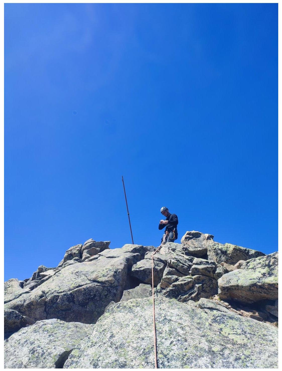
- Section R4–R5. Exit to the 2nd Western
peak
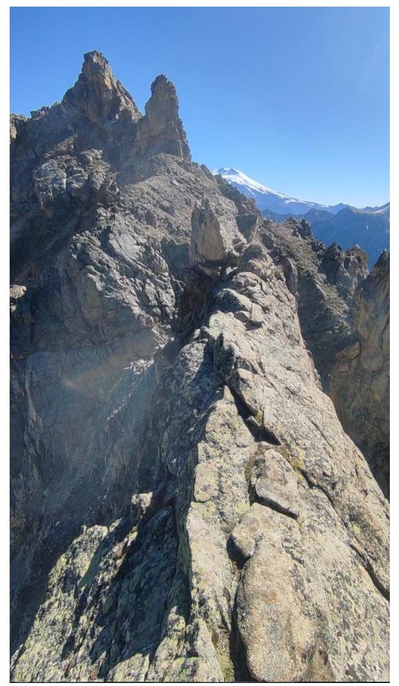
- View of the "Saw": R10. Further in the background, the gendarme (R13) and the Eastern
peak.
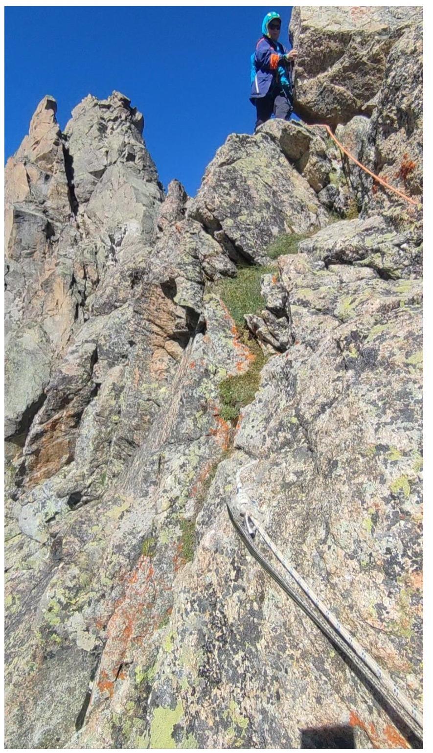
- Exit from the saw, station for rappel on the slab
R11.
- Eastern peak. View from R16.