- Rock climbing category
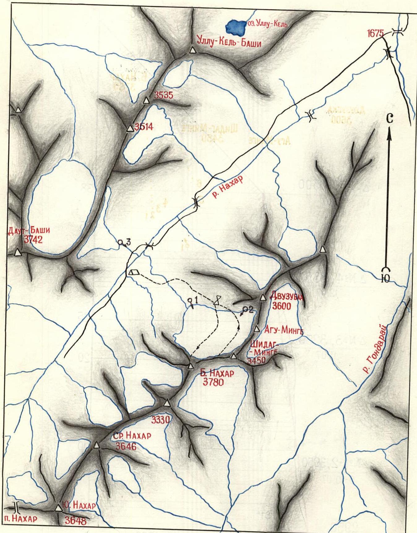
- Western Caucasus, Nakhar gorge
- Bolshoi Nakhar via the northeast wall
- Proposed category: 6th category of complexity, first ascent
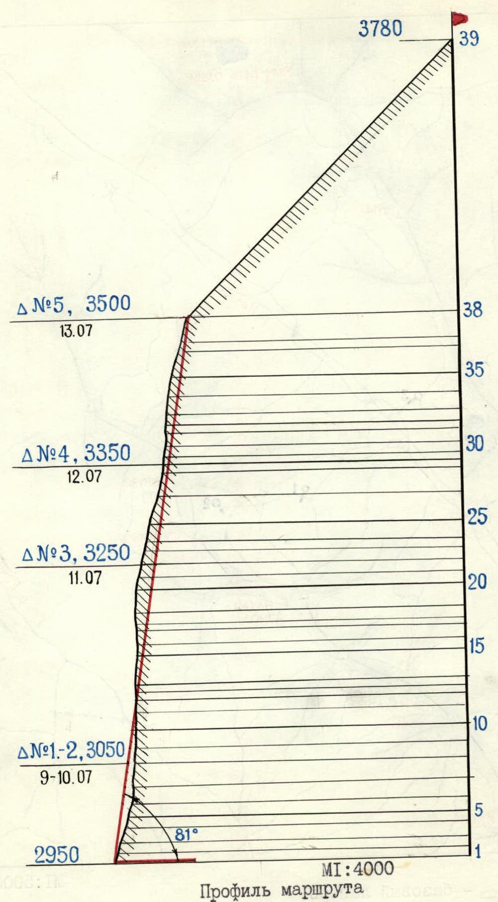
- Height difference — 930 m, length — 1320 m
Length of sections with 5–6 category of complexity — 730 m
Average steepness of main sections 81° (2950–3500), including 6th category of complexity:
- 86°, 60 m (3010–3050);
- 88°, 185 m (3070–3200);
- 90°, 10 m (3230–3240);
- 80°, 100 m (3250–3320);
- 85°, 100 m (3350–3430)
- Pitons hammered in:
rock 197/31, bolted 7/4, chocks 37/7, ice screws 0/0
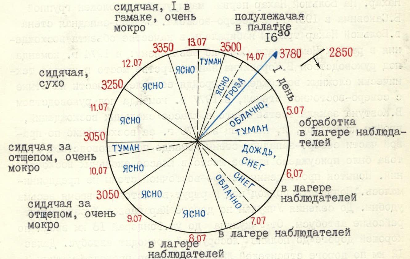
- Team's climbing hours — 66 and days — 7
- Overnights: 1, 2 — sitting on a ledge; 3 — sitting on shelves;
4 — sitting, 1 in a hammock; 5 — semi-reclining in a tent
- Team leader: Yuri DJAPARIDZE, Master of Sport
Team members:
- Oleg ACHASOV, Candidate for Master of Sport
- Alexander RAGOTNER, Candidate for Master of Sport
- Stanislav SHABUNYA, Candidate for Master of Sport
-
Coach: Galina Shchepalova, Master of Sport, class II
-
Approach to the route: July 5, 1982
Summit — July 14, 1982 Return — July 14, 1982
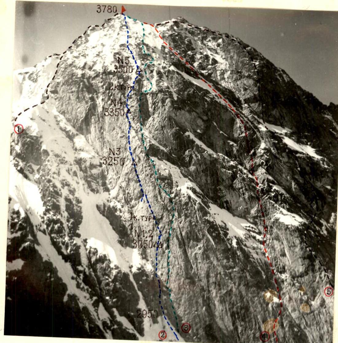
General photo of Bolshoi Nakhar peak. Taken from point 2 on July 9, 1982, at 9:00 with a T-22 lens with a focal length of 75 mm. The height of the shooting point is about 3100 m, the distance from the wall is about 1 km.
Route:
-
- Pomazuiev's route via the NE ridge, 5A category of complexity
-
- Team's route
-
- Korablin's route via the NW wall, 6th category of complexity
-
- Kovtun's route via the center of the NW wall, 5B category of complexity
-
- Kotov's route via the NW wall, 5B category of complexity
- Kotov's route via the NW wall, 5B category of complexity
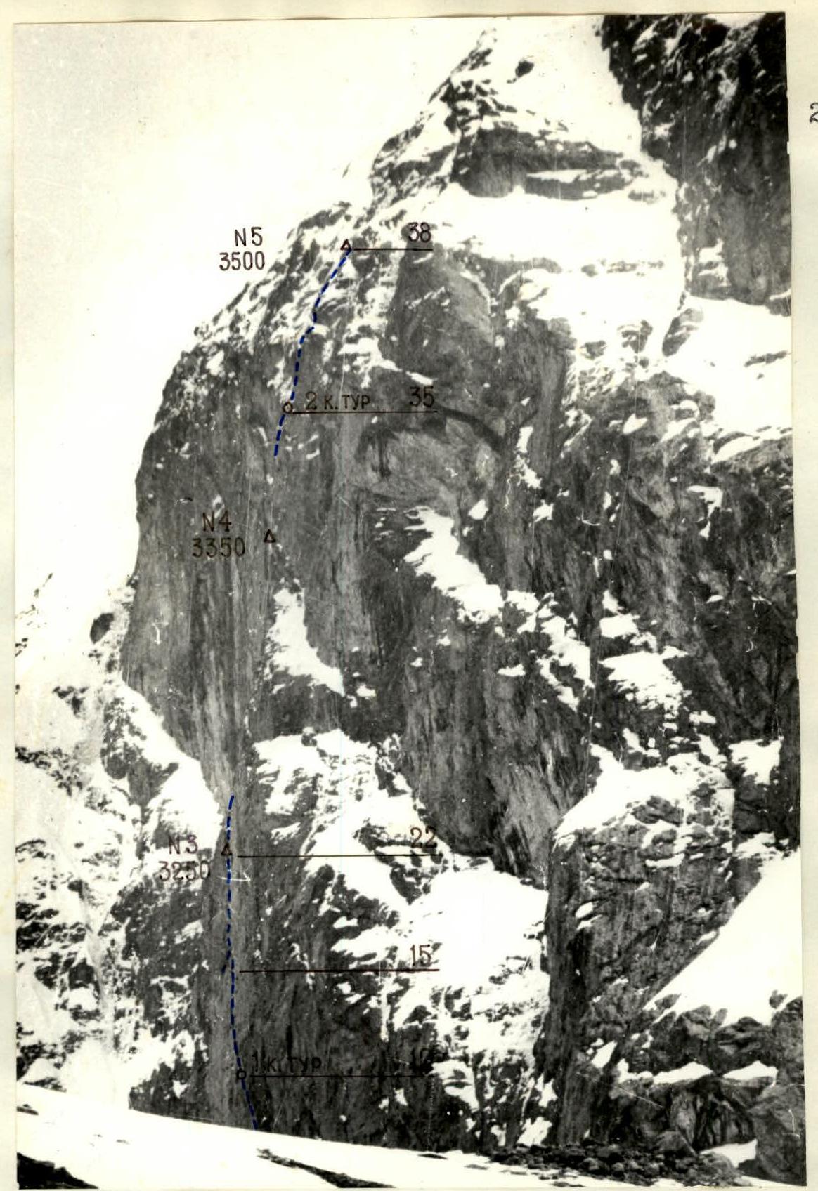
Profile of the NE wall of Bolshoi Nakhar peak on the right. Taken from point 1 on May 29, 1982, at 16:00 with a Helios-44-2 lens with a focal length of 58 mm. The height of the shooting point is about 2700 m, the distance from the wall is about 2 km.
It was not possible to take a photo of the wall profile from the left, as the route is blocked by the NE ridge, along which Pomazuiev's route passes.
Legend for the diagram:
- ∼ — base camp
- λ̂ — observer camp
- б' — photo shooting points
ASCENT SCHEDULE
Brief overview of the ascent area
Bolshoi Nakhar peak is located in the mountain range of the northern spur of the Main Caucasian Range between the Nakhar and Gondoray rivers. The massif is a twelve-kilometer rocky ridge with three main peaks located from south to north:
- South Nakhar
- Middle Nakhar
- Bolshoi Nakhar
The first ascent to the Nakhar massif was made in 1904 by A. Fisher, who climbed Middle Nakhar peak accompanied by H. Iossi. The first route to Bolshoi Nakhar was laid by a group led by B. Sakovich in 1937 from the northeast. The northwest wall of Bolshoi Nakhar peak was chosen as an object of ascent three times within the framework of the USSR Alpine Championship:
- in 1974, a team led by B. Korablin took third place in the category of technically complex ascents, passing it on the left side at the junction with the northeast wall;
- in 1977, a team led by V. Kovtun took third place in the category of rock climbing ascents, passing through the center;
- and finally, in 1978, a team led by E. Kotov was awarded second place in the category of rock climbing ascents for ascending the right part of the northwest wall.
No attempts were made to ascend the northeast wall. The approach to the route is now very convenient:
- There are regular buses from Karachaevsk to Uchkulan.
- From Uchkulan to Gondoray gorge, 18 km uphill along a good road to the "lumberjacks" clearing, a bus passes.
- Further, 12 km along the road built by power line constructors through Nakhar gorge, vehicles like GAZ-66 and ZIL-130 pass.
- The ascent to the cirque under the wall of Bolshoi Nakhar peak takes about 2 hours along scree and grassy slopes.
Tactical actions of the team
The tactical plan for the ascent was drawn up based on photographic materials, reconnaissance results, and the assumption that the weather and route conditions would be "normal". Five potential overnight locations were identified, and as a result, the route was divided into 6 sections. However, on July 3, upon arriving under the route, we saw that due to an abnormal summer and prolonged bad weather, the route's condition was far from normal. Waterfalls flowed from the "roof" where much snow had accumulated, flooding the entire wall, and the melting did not stop even at night. Already when passing the first 100 m of the route, it became clear that the problem of water turned, so to speak, to its reverse side: the difficulty was not in finding water, but in getting rid of it.
The movement regime was mainly determined by the fact that:
- the wall was lit by the sun from 8:00 to 10:30
- by 12:00, the water "shower" gained half its strength
- by 15:00, it was possible to move only in continuous streams of water
In such a situation, the group started moving at 6:30–7:00 to use the relatively dry time, and after 13:00, only processing continued — preparation for the next day. As a rule, by 17:00, all work on the wall stopped, and the pair returned to the bivouac from processing.
On the route (its wall part), there are no convenient platforms for overnight stays, and in such increased waterlogging conditions, hammocks are practically not helpful, as moisture is very intensively drawn through the hammock fabric and from the wall when in contact with it.
The most comfortable overnight stay was No. 3, and the least comfortable was No. 4.
The only deviation from the tactical plan — a repeated overnight stay at bivouac 1 — was caused by the fact that the first pair, having reached the area of the 2nd planned overnight stay at 15:00, did not find a suitable place for a bivouac, so it was decided not to transfer the bivouac to the wettest time, but to secure the ropes and spend the night at bivouac 1 again. Such a deviation from the original plan, foreseen even under the wall, allowed the group to save more dry things without violating the overall movement schedule, as the group moved to bivouac No. 3 the next day.
On the wall, the insurance of the first climber, who went without a backpack, was carried out with a double rope, all others moved along the secured rope with upper insurance with backpacks attached to the lower part of the harness, using two jumar; rucksack extraction was not performed.
There were no permanent rope teams on the wall; the leaders changed all the time:
- Dzaparidze went first on sections R6–R8, R15–R19;
- Achasov — on sections R10–R15, R27–R34;
- Ragotner — on sections R22–R27, R34–R38;
- Shabunya — on sections R0–R6, R8–R10, R19–R22.
On the "roof", the rope teams Achasov — Dzaparidze and Shabunya — Ragotner moved autonomously.
The following sections were pre-processed: 1–6, 8–10, 10–15;
Rappel lines were organized on sections: 1–38.
Ascent timeline:
- On July 5, sections 1–6 were processed;
- July 6–8, the team stayed in the observer camp due to unfavorable weather conditions;
- On July 9, the team reached the overnight stay on a ledge and processed sections 8–10;
- On July 10, sections 10–15 were processed;
- On July 11, the team passed the processed sections and reached the 3rd overnight stay;
- On July 12, the team passed sections 22–28;
- On July 13 — 28–38;
- On July 14, the team passed the "roof" and descended to the observer camp.
Safety measures on the route:
- use of double rope and non-inertial energy-absorbing devices;
- blocking of pitons;
- organization of overnight stays and insurance under awnings;
- increased ration of products and fuel reserve due to wet route conditions.
There were no accidents or injuries on the route. Problem-solving:
- The slab at the exit to the beginning of the basalt vein — passed on ITO, 5 bolted pitons were hammered in.
- Two cornices along the vein — passed on ITO.
- The slab interrupting the vein at the bottom of the "triangle" — passed with a pendulum, 1 bolted piton was hammered in.
- Cornices of the "triangle" — passed on ITO.
- Exit to the roof — a passage was found to the right of the large cornices on ITO, 1 bolted piton was hammered in. Communication with observers was carried out using a "Vitalka" radio station with a spare set of batteries. In addition, voice communication was maintained up to the very top of the wall.
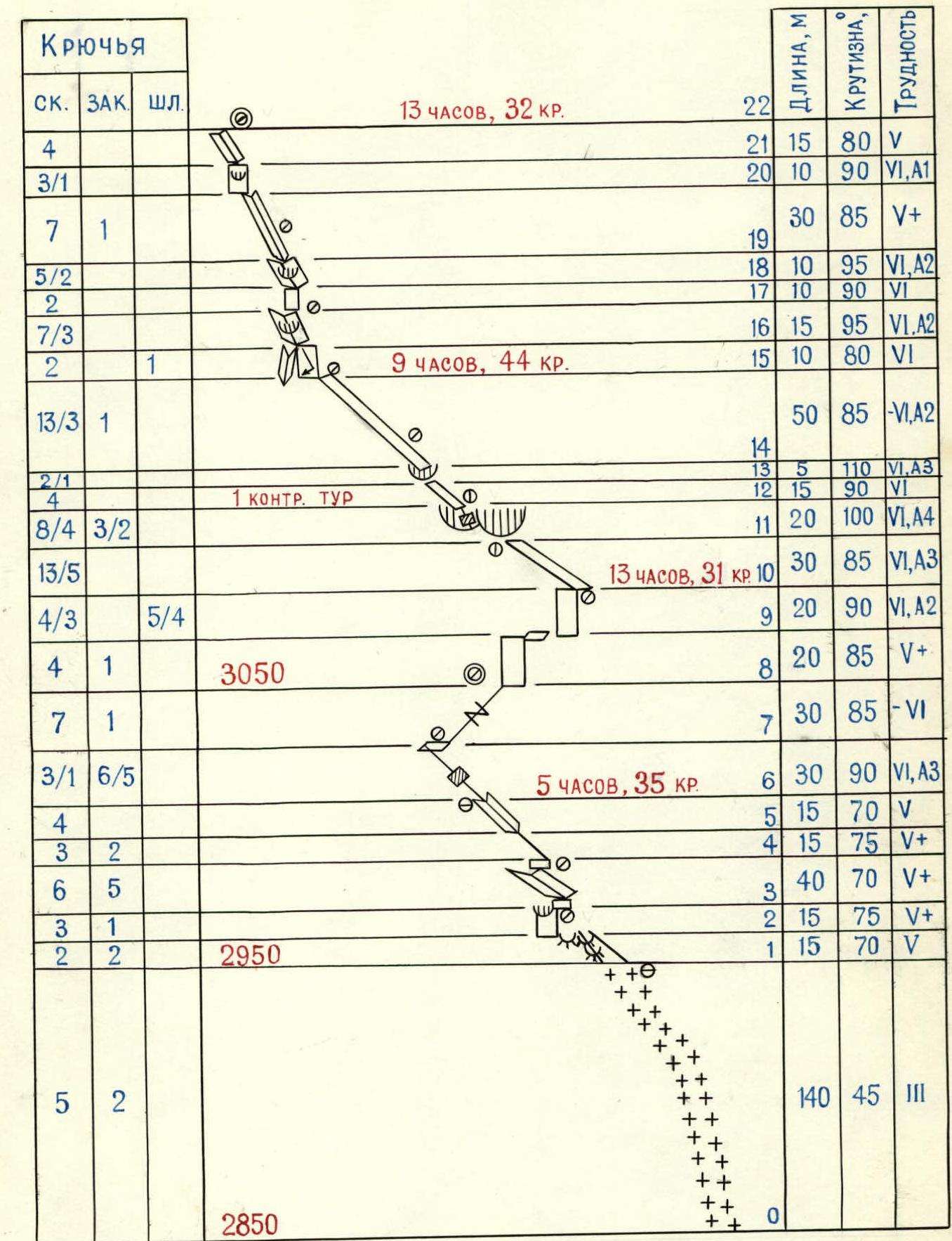
Route diagram. Climbing hours — 66. Total number of pitons and chocks — 241.

Route description by sections
1–2. Along the "ram's foreheads" of the right side of the couloir towards the wall with a cornice, which is clearly visible from below. Thin pitons are needed; when exiting to the wall, it is possible to use "stoppers". 2–3. Along the wall under the cornice through rocks covered with lichen. Climbing is complicated by water flowing over the rocks. The belay point under the cornice is protected from water flows in the absence of wind. Belaying is done while sitting in a harness. 3–4. From under the cornice to the right to a 5-meter slab leading to a vaguely expressed internal corner turning into an 8-meter wall, along which to the right — up to a small granite rib separating two couloirs. The rocks are wet, covered with lichen. Belay point when exiting to the rib. Belaying is done in a harness, it is wet. 4–6. Along the rib, exit to a vaguely expressed internal corner, then along its left part to the beginning of a shelf going left — up along the base of the NE wall. You can stand on the shelf, but water flows along the wall. 6–7. Retrieved from https://summitx.info/media/1/G2O2YX78VQzAEkHEp1XrKRdddnLl2ZRn/img-0.jpeg↗
Producing images for storage.


