1. Nature of the Ascent
1.1. Class of ascent — rock climbing. 1.2. Area of ascent — Western Caucasus, Nakhar region. 1.3. Peak — B. Nakhar, 3780 m, northwest wall (B. Koralin route). 1.4. Category of complexity — 6B. 1.5. Number of pitons driven: 1) for belaying — 23; 2) for creating artificial climbing holds (ITCH) — 5; 3) rock pitons — 23; 4) ice pitons — 0; 5) bolt pitons — 1. 1.6. Height difference — 1000 m. Length of sections — 712 m. Average steepness — 80°. 1.7. Number of climbing hours — 37 hours. 1.8. Number of overnight stays — 2. Including — 1 sitting bivouac. 1.9. Group composition: 1) Dorokhov B.F. — leader, Candidate for Master of Sports; 2) Pronin A.V. — participant, Candidate for Master of Sports; 3) Malamid V.M. — participant, Candidate for Master of Sports; 4) Rumyantseva N.A. — participant, Candidate for Master of Sports. 1.10. Team coach — Zakharov P.P. 1.11. Departure date — August 9, 1982. Return date — August 11, 1982.
Table
of the main characteristics of the ascent route. Ascent route — Peak Bolshoy Nakhar via the northwest wall, 6B category of complexity, Koralin B.N. route, height 3780 m.
Height difference of the route — 1000 m. Including complex sections — 785 m. Average steepness of the route — 80°.
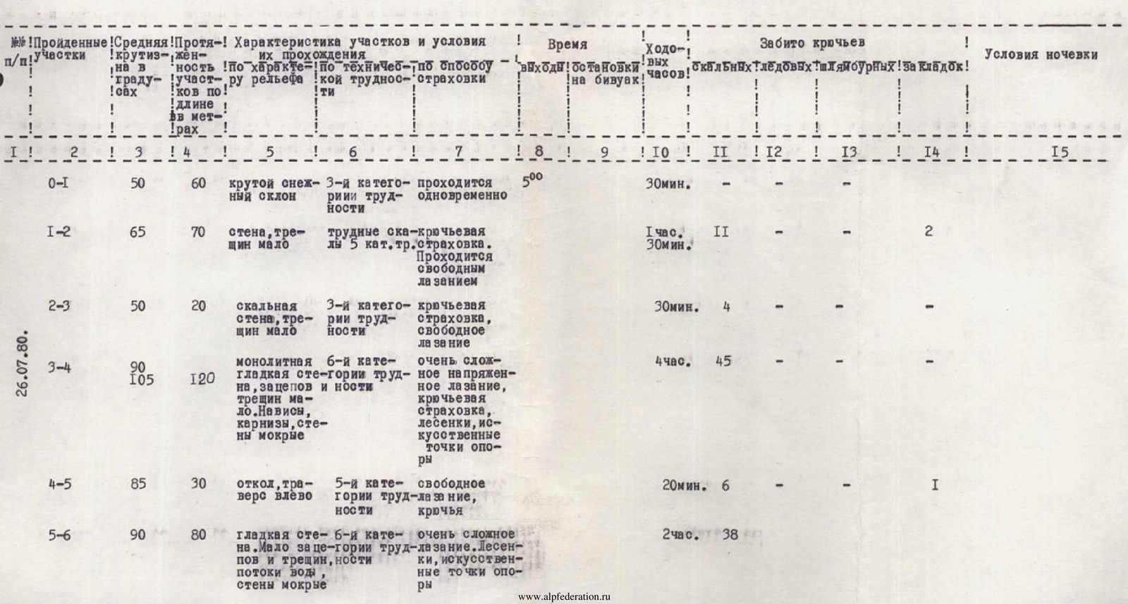

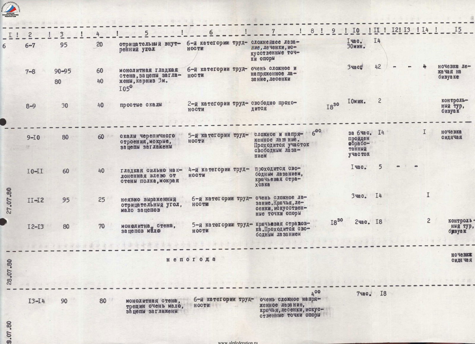
| Date | Section | Steepness | Length | Nature of terrain | Difficulty (category of complexity of sections) | Condition | Weather conditions | Rock pitons | Ice pitons | Bolt pitons | Notes |
|---|---|---|---|---|---|---|---|---|---|---|---|
| 09.08. | R0–R1 | 50° | 60 m | Snow-ice slope at the end of the rantkluft | – | From 10 am, ice and stones possible from the wall | good | – | – | – | – |
| R1–R2 | 65° | 50 m | Wall | 4 | Live stones on the shelves, stones and ice from the wall and roof | same | 10 | – | – | Including 3 chocks. | |
| R2–R3 | 65° | 50 m | Wall | 3 | Same | – | 10 | – | – | – | |
| R3–R4 | 90° | 50 m | Wall with overhanging sections | 6 | Monolith | – | 15 | – | – | – | |
| R4–R5 | 60° | 30 m | Inner corner | 4 | Rocks are solid | – | 5 | – | – | – | |
| R5–R6 | 20° | 15 m | Shelf | 3 | Same | – | 3 | – | – | – | |
| R6–R7 | 90° | 15 m | Wall | 5 | Monolith | – | 5 | – | – | – | |
| R7–R8 | – | 25 m | Horizontal, narrow shelf | 4 | Shelf is covered with ice | – | 6 | – | – | Including 2 ledges, a sitting bivouac is possible | |
| R8–R9 | 80° | 10 m | Wall | 5 | Rocks are solid | Good | 3 | – | – | – | |
| R9–R10 | – | 20 m | Horizontal, narrow shelf | 4 | Same | same | 5 | – | – | Including 2 chocks | |
| R10–R11 | 90° | 7 m | Inner corner, traverse to the right side | 6 | Monolith, icy rocks | – | 2 | 1 | – | – | |
| R11–R12 | 90° | 25 m | Inner corner with overhanging sections | 6 | Rocks are solid | – | 10 | – | – | Including 2 chocks | |
| R12–R13 | 70° | 10 m | Inclined slab | 4 | Rocks are solid | – | 2 | – | – | – | |
| R13–R14 | 95° | 15 m | Inner corner | 6 | Rocks are like feathers, some are live | – | 4 | – | – | All chocks | |
| R14–R15 | 80° | 15 m | Wall | 5 | Monolith | – | 3 | – | – | – | |
| R15–R16 | 70° | 55 m | Inclined slabs | 5 | Monolith, rocks are covered with ice | – | 16 | – | – | A convenient bivouac is possible on the right under the base of the wall | |
| R16–R17 | 70° | 50 m | System of inclined shelves | 5 | Rocks are solid, covered with water | – | 14 | – | – | – | |
| R17–R18 | 90° | 15 m | Wall | 5 | Rocks are solid | good | 4 | – | – | – | |
| R18–R19 | 90° | 25 m | Inner corner | 5 | Rocks are destroyed | same | 7 | – | – | – | |
| R19–R20 | 70° | 30 m | Inclined slab | 4 | Rocks are solid, ice and stones possible from the roof | – | 8 | – | – | Including 4 chocks, an inconvenient bivouac (sitting) | |
| 10.08. | R20–R21 | 95° | 80 m | Wall | A3 | Monolith, ice and stones possible from the roof | – | 10 | – | 30 | – |
| R21–R22 | 80° | 50 m | Wall with overhanging sections | 5 | Rocks are solid | good | 15 | – | – | 2 chocks | |
| R22–R23 | 80° | 100 m | Wall, with inner corner, wall | 5 | Rocks are heavily destroyed | good | 24 | – | – | 4 chocks | |
| R23–R24 | 70° | 150 m | Wall | 5 | Rocks are icy | Graupel, wind | 28 | – | – | At the end of the rope, under the base of the rock counterfort, a bivouac is possible | |
| R24–R25 | 60° | 10 m | Snow-ice slope with rock islands (traverse to the right upwards) | 4 | Snow is sour, ice under the snow, piton belay through rocks | graupel, snow, wind | 23 | – | – | Exit at the end to the ridge leading to the summit, convenient bivouac | |
| 11.08. | R25–R26 | 60° | 200 m | Ridge | 2 | Snow-covered rocks | Good | – | – | – | Along the ridge, exit to the summit. |
3. Explanations for the Characteristics Table
3.1. Most complex sections of the route:
- inner corner (sections R10–R11 and R11–R12), passage of which is technically complex (smoothed wet rocks, water in the form of rain) — a vertical monolithic wall with overhanging sections, mainly using artificial climbing holds (ITCH).
3.2. The route is generally safe. However, one should consider the possibility of avalanches from the "roof," which may partially affect sections R20–R21 and the lower part of the route. Avalanches occur:
- during bad weather;
- when the weather changes in the morning hours.
At the beginning of the route, one should be cautious of avalanches or snow collapses from the slope marked * (the group observed a snow slope collapse, and the route was partially affected by the collapsed slope).
3.3. The route is distinguished by its logic, steepness, and technical complexity of individual sections.
3.4. A group of 4 people should have at least 2 ice axes.
4. Descent Recommendations
4.1. Descent from the summit to the site of the 2nd bivouac and further along the ridge for about 200 m, then left into a wide rocky cirque and further left down the cirque (complexity not higher than category 2) — 1–1.5 hours. Stick to its left edge as you descend.
The main landmark on the descent: the group should see the saddle to the right and the lake in the valley simultaneously or only the saddle. If the group sees only the lake in the valley, it is a sure sign that they are descending via the wrong cirque (there are 2 cirques on the descent). If the group still ends up in the wrong cirque, they should climb out onto the ridge to the right.
After 1.5 hours of descent along the cirque and exiting onto a flattening rocky slope, one should find a descent from the cirque to the left onto a rocky counterfort and along it onto the talus slopes (at the end — 20 m rappel through a ledge) and further onto the saddle.
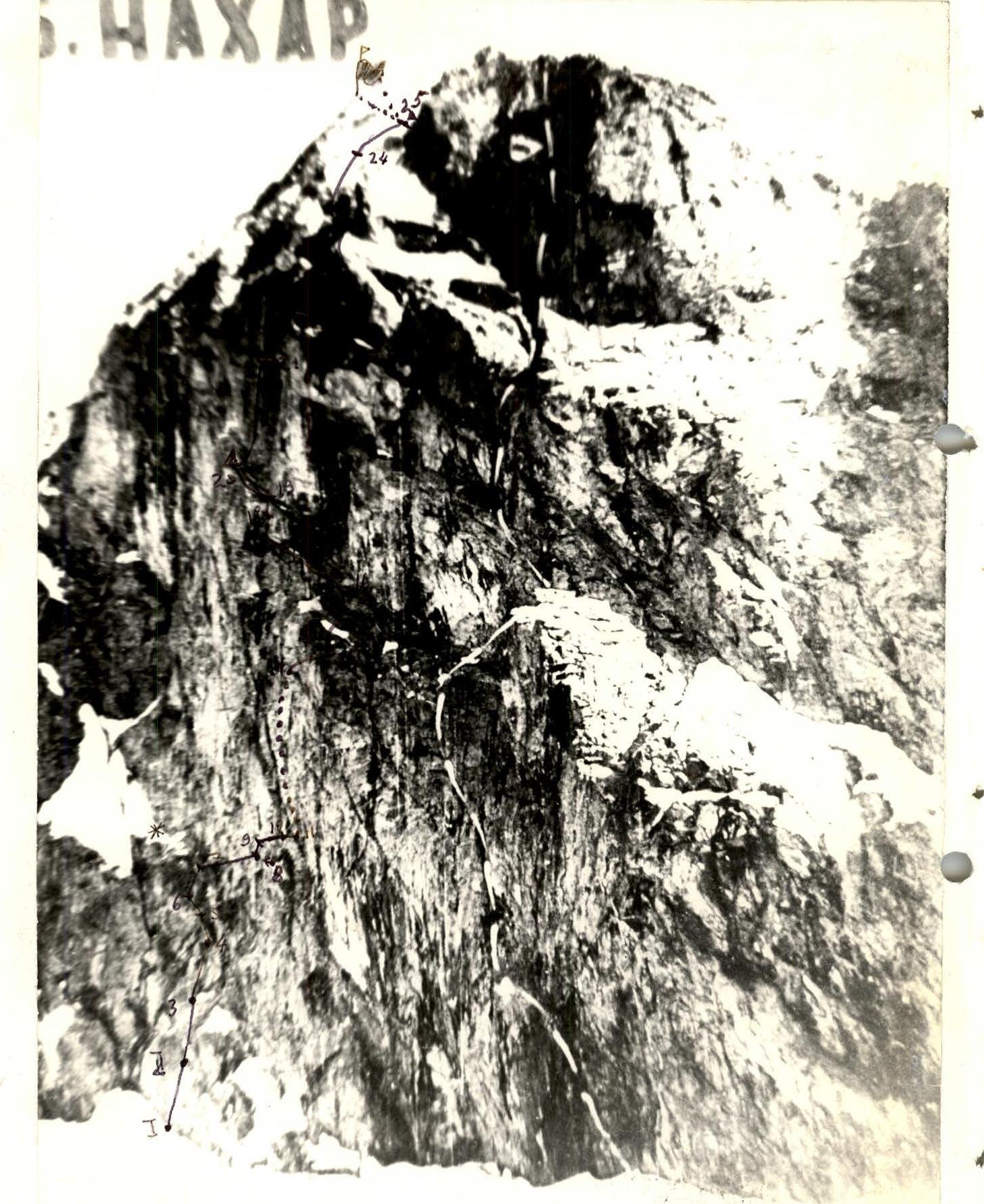
5. Route Diagram in UIAA Symbols
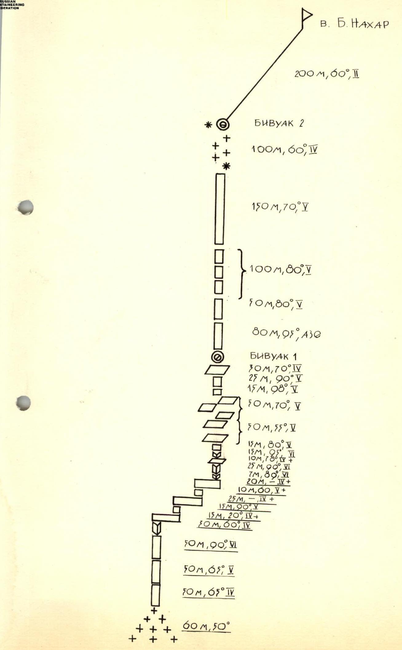 V. B. Nakhar
200 m, 0°
BIVOUAC 2
100 m, 60°, 4
150 m, 70°, 1
100 m, 80°
50 m, 80°
80 m, 95°, A3
BIVOUAC 1
30 m, 70°, 4
25 m, 90°
15 m, 90°
50 m, 70°, 5
15 m, 80°, 1
14 m, 95°, 6
10 m, 78°, 5
25 m, 90°, 6
7 m, 80°, 1
20 m, –, 4
10 m, 0°, 5
25 m, –, 5
14 m, 95°, 5
15 m, 20°, 1
30 m, 60°, 4
50 m, 90°, 6
50 m, 5°
50 m, 65°, 4
60 m, 50°
V. B. Nakhar
200 m, 0°
BIVOUAC 2
100 m, 60°, 4
150 m, 70°, 1
100 m, 80°
50 m, 80°
80 m, 95°, A3
BIVOUAC 1
30 m, 70°, 4
25 m, 90°
15 m, 90°
50 m, 70°, 5
15 m, 80°, 1
14 m, 95°, 6
10 m, 78°, 5
25 m, 90°, 6
7 m, 80°, 1
20 m, –, 4
10 m, 0°, 5
25 m, –, 5
14 m, 95°, 5
15 m, 20°, 1
30 m, 60°, 4
50 m, 90°, 6
50 m, 5°
50 m, 65°, 4
60 m, 50°