The peak B. Nakhar 3780 m is located in one of the spurs of the Greater Caucasus Range. The climbing area is characterized by a significant distance between the base camp and the nearest settlement. From Uchkulan, a mountain road goes along the Gondoray valley to the reserve. This road often becomes impassable for vehicles in bad weather.
It takes 3 hours to drive from Uchkulan to the reserve. Then the road goes to the Makhar valley, to the right and up to the tourist camp "Globus" and further to the narzan springs, then through a swampy lowland to the logging area, near which there is a large clearing ending with a log across the Makhar River.
In good weather, a car can drive right up to the clearing, which becomes impossible after heavy rains. Our car was able to pass along the road through the swamp after five days of excellent weather.
From the bridge, the trail goes along the right bank of the Makhar River to a side valley leading to peak Nakhar. From the point where the stream flows into the river, the trail follows the stream and moraine through:
- sheep's foreheads,
- glacier,
to the base camp location on a lateral moraine.
It takes two days to travel from the bridge to the base camp. This time depends on the amount of gear for the planned number of days. It is convenient to set up the base camp in the upper part of the moraine, where it flattens out noticeably.
The route to peak B. Nakhar was first climbed in 1974 by a group from L.O.S.D.S.O. "Zenit" via the northeast wall, category 6B. The team consisted of:
- I. Korablin — captain
- Grubrin — member
- Surzhik — member
- Shopin — member
- Kryukov — member
- Snatkov — member
A route of category 3B difficulty was established from the south to the peak.
The last ascent via this route was made by a group of climbers from Dnipropetrovsk, led by Grishnevich, on August 16, 1969.
2. Climbing Conditions in the Area of Peak B. Nakhar
a) Relief. Peak B. Nakhar is located in a spur descending to the west and dividing a large cirque into two parts — northeast and southwest. The northeast ridge is situated on the left side of the northeast wall of B. Nakhar, near peak Shindak-Minge. The peaks of the Gondoray area are not very high, but some cirques are bounded by kilometer-high walls. Thus, 150–200 m to the right of the start of the first ascent route, there is a route of category 6B, featuring 900 m of wet, sheer walls with numerous waterfalls. The sun illuminates this wall only in the early morning. On the route, snow lies in the upper part and flows down in abundant streams. The rocks on the route are mainly granite and covered with scaly moss. The southern part of the summit ridge is heavily destroyed and convenient for descent. The route of category 3B passes here. The northern ridge ends with a saddle between peak Shindak-Minge and peak B. Nakhar.
The path to the saddle is challenging and involves traversing a large, snowy slab with gullies carrying streams of snow and ice, transitioning into ice falls in the lower part.
b) Weather conditions. The weather in the climbing area is characterized by frequent variability. The chain of peaks, including peak B. Nakhar, is located on the path of southwesterly winds, which bring moist clouds from the sea, resulting in rainfall on this barrier.
The route is sunlit from 8:00 to 14:00. The daytime temperature does not drop below 15 °C. At night, it drops to 3–5 °C.
3. Preliminary Preparation and Reconnaissance
Five out of six team members are part of the Kiev S.D.S.O. "Burevestnik" and have been training and climbing together for many years.
The plan included uniform, sequential preparation of the team for the intended ascent, with a gradual increase in load. According to the plan, the team arrived at the "Dombay" alpine camp, where they completed a climb to peak Belyala-Kaya, category 4B, from the northwest (Grigorenko–Grigoda route) after some training ascents.
While working as instructors at "Dombay" alpine camp, Savchuk, Yakovlev, Pomazuev, and Evseev took participants on trips to the Kitche-Murudzhu valley, from where peak B. Nakhar is visible.
During this time, Savchuk and Pomazuev made sketches of peak B. Nakhar from the southern ridge of peak Lyal using a 20x telescope and determined the ascent route.
4. Organizational and Tactical Plan
The plan was to complete the route in three days, with two days of observation and route processing.
Day I. Observation of the route, preliminary processing, and observation of the route's passage.
Day II. Overnight stay on the ridge and passage of the main section of the route.
Day III. Ascent to the summit and descent to the base camp. This tactical plan was largely followed. The passage of all sections of the route was carried out as follows:
- The first rope team processed the section
- The second and third teams organized rope hauling and passed on the freed ropes
- The leaders changed throughout the ascent
The first climber went with a lightened backpack, and in the most challenging areas, without a backpack. A diverse set of rock pitons and cams, a sufficient number of carabiners, and double-rope belaying ensured confident progress and reliable safety.
Hot meals were prepared twice a day (morning and evening). Each participant received individual rations for the day.
Overnight stays were planned in a tent and hammocks. This movement tactic proved itself and ensured safety, clear team work, and sufficient rest at the bivouac. Radio communication with the base camp was maintained via "Vitalka". The base camp maintained radio communication with the KSP of the Dombay area and later with "Dombay" alpine camp via "Nedra". The descent from the summit was planned via:
- the southern ridge.
5. List of Group Equipment
- "Pamirka" tent — 1 piece
- Main rope — 3 × 40 m, 2 × 80 m
- Main rope, 3 m — 6 ends
- Loops made of reepschnur — 10 × 3 m
- Reepschnur for consumption — 20 m
- Rock pitons: a) titanium, various — 25 pieces, b) titanium wedges — 6 pieces, c) duralumin wedges — 4 pieces.
7. Route Passage Order
First day — August 1.
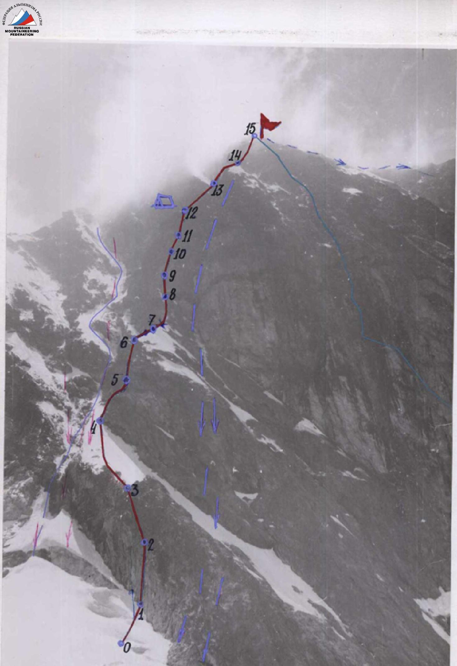
The route starts 120 m to the left of the category 6B route. At 6:00, two rope teams left for preliminary route processing: Kuzmuk — Bodnik, Pomazuev — Savchuk. From the bivouac on the gray talus, the group ascended up the glacier to a large randkluft. By passing it from below and to the right, they approached the start of the route. At 7:00, the rope team Kuzmuk — Bodnik began processing the route. Bodnik led the first pitch. The first rope (section 1) was climbed using complex rock climbing techniques. The start is challenging, requiring advanced rock climbing skills. The route goes:
- left of the overhanging part, up a vertical slab 30 m with few holds to an internal angle,
- up the internal angle 30 m to the left and up to a narrow, inclined ledge,
- from the ledge, left and up along a not very pronounced external angle (upper part — 30 m),
- up the wall to a small ledge before a 10 m smooth slab, which ends with a snow patch.
Sections 2 and 3 were climbed using ladders. The snow patch is shaped like a buttress with an icy upper part. The route continues:
- along the snowy-icy ridge (section 4) to a rock wall 10 m high, passed on the left,
- up a crack 25 m under an overhanging part of gray rocks.
Upon reaching the overhang, the pair began descending down at 17:00. Both teams were back at the base camp by 19:00. 280 m of rope were placed that day. The areas of falling ice and stones were finally identified. Snow avalanches descend irregularly along the couloir to the left of the route, dumping ice and stones into a large randkluft. To the right of the route, water flows, and stones and ice fall.
Once again, it is confirmed that the route is logical and correctly chosen.
Second day — August 2
The weather is good in the morning. At 7:00, the group approached the wall and began ascending the section along the placed ropes. The teams organize the hauling of backpacks and ropes.
The pair ascends up under the overhanging part of the gray rocks and further to the wet, moss-covered slabs 50 m (section 6). The slabs end with a narrow ledge before a snow patch.
The snow patch (section 7) is overcome along the ridge, with an exit under light-colored overhanging rocks. Here, a piton is hammered into the wall, and a control cairn is made.
The overhanging rocks are bypassed on the right via a 50 m couloir with formed ice (section 8), which ends with a sheer wall 20 m high. The wall is passed on the left.
Then the route goes left and up to a small ledge (section 9) and from it right and up 30 m to a sheer wall, which is bypassed on the right. Further, along slabs alternating with walls (section 10), to a sloping ledge. From the ledge, straight up along a vertical crack 30 m and slabs (section 11) to a ledge in an internal angle. Climbing remains challenging and is done in fog. Visibility is 30–50 m. Ladders are often used.
The work involves:
- medium pitons
- thin channels
We start looking for a place to spend the night. The internal angle ends with slabs (section 12), the steepness of which decreases noticeably.
We reach a ledge covered with snow. We dig out a platform in the snow and organize a bivouac. The weather deteriorates completely, with a fine drizzle. Darkness falls.
Those in the tent:
- four people
On the ledge above the tent:
- two people are accommodated in hammocks, covered with polyethylene.
Third day — August 3
The weather is good. A sunny, windless day. We dry the wet equipment and leave for the route at 9:00. On the ledge where the hammocks were, we leave a second control cairn. Along the ledge, we move left, then up the internal angle and right and up along rocks of medium difficulty with alternating belays to a 10 m wall. Then right and up to the pre-summit ridge, which transitions into the so-called Dome of Big Nakhar. Further, left and up along light-colored blocks — exit to the summit. At 12:00, the first rope team approaches the control cairn on the summit of Big Nakhar. We retrieve the note left by Korablin's group and begin descending via the category 3B route at 12:30. The group reaches the saddle in the ridge in 3 hours and returns to the base camp by 17:30.
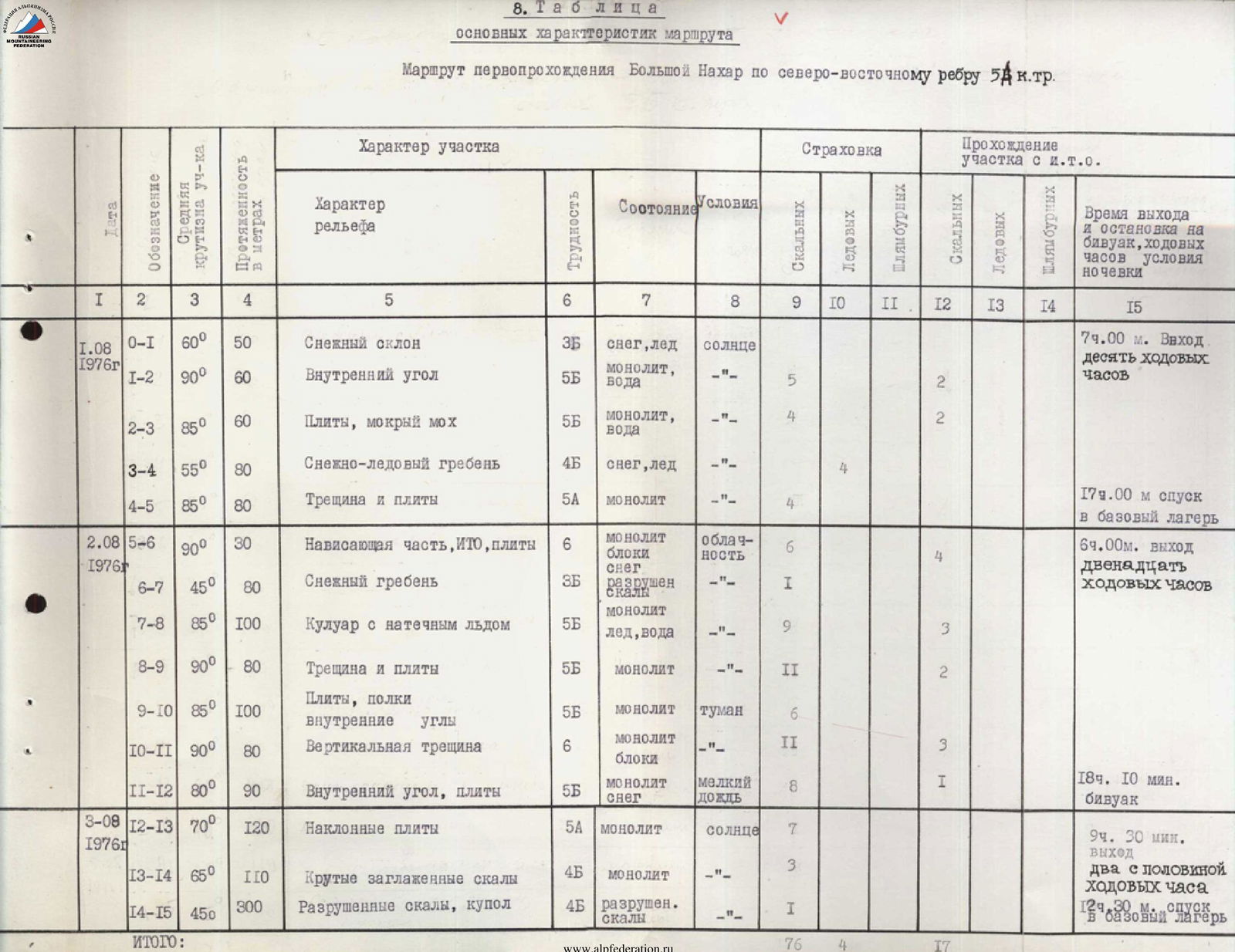
8. Table of Main Route Characteristics
First ascent route to Big Nakhar via the northeast ridge, category 5A.
| Date | Section | Steepness (°) | Length (m) | Terrain Characteristics | Difficulty | Condition | Weather | Rock Pitons | Ice Axes | Drill Holes | I.T.O. (Rock) | I.T.O. (Ice) | I.T.O. (Drill) | Time and Conditions |
|---|---|---|---|---|---|---|---|---|---|---|---|---|---|---|
| August 1, 1976 | R0–R1, R1–R2 | 60°, 90° | 50, 60 | Snow slope, internal angle | 3B, 5B | snow, ice; monolith, water | sun; —"— | 5 | 2 | 7:00. Departure — 10 working hours | ||||
| R2–R3 | 85° | 60 | Slabs, wet moss | 5B | monolith, water | —"— | 4 | 2 | ||||||
| R3–R4 | 55° | 80 | Snowy-icy ridge | 4B | snow, ice | —"— | 4 | 179 m — descent to base camp | ||||||
| R4–R5 | 85° | 80 | Crack and slabs | 5A | monolith | —"— | 4 | |||||||
| August 2, 1976 | R5–R6 | 90° | 30 | Overhanging part, ITO, slabs | 6 | monolith, blocks | overcast | 6 | 4 | 6:00. Departure, 12 working hours | ||||
| R6–R7 | 45° | 80 | Snow ridge | 3B | snow, destroyed rocks | —"— | 1 | |||||||
| R7–R8 | 85° | 100 | Couloir with formed ice | 5B | ice, water | —"— | 9 | 3 | ||||||
| R8–R9 | 90° | 80 | Crack and slabs | 5B | monolith | —"— | 11 | 2 | ||||||
| R9–R10 | 85° | 100 | Slabs, ledges, internal angles | 5B | monolith | fog | 6 | |||||||
| R10–R11 | 90° | 80 | Vertical crack | 6 | monolith, blocks | —"— | 11 | 3 | ||||||
| R11–R12 | 80° | 90 | Internal angle, slabs | 5B | monolith, snow | light rain | 8 | 1 | 18:10. Bivouac | |||||
| August 3, 1976 | R12–R13, R13–R14 | 70°, 65° | 120, 110, 300 | Inclined slabs, steep smooth rocks, destroyed rocks, dome | 5A, 4B, 4B | monolith, monolith, destroyed rocks | sun; —"—; —"— | 7, 3, 1 | 9:30. Departure — 2 hours 30 minutes working hours. 12:30. Descent to base camp |
9. Route to peak B. Nakhar via the Northeast Ridge, category 5B
category 6B route (Korablin's path) → category 5B route (first ascent) → waterfalls, ice → snow, ice