I. North Caucasus Championship in the name of S. M. Kirov
Category of technically complex ascents
Report on the ascent to the summit of Bolshoy Nakhara via the north-eastern edge, 5B cat. diff. (first ascent)
Team composition:
- Team leader — Pomazuev V. V., born 1941, Candidate Master of Sports, "Burevestnik", Kiev
- Deputy leader — Savchuk V. A., born 1940, Candidate Master of Sports, Kiev
- Participant — Yakovlev V. A., born 1938, Candidate Master of Sports, Kiev
- Participant — Kuzmuk V. V., born 1952, Candidate Master of Sports, Kiev
- Participant — Bodnik V. N., born 1949, Candidate Master of Sports, Kiev
- Participant — Evseev Yu. I., born 1936, Candidate Master of Sports, Rostov-on-Don
Team coaches: Magomedov Kh. K., Ovcharov V. V.
Caucasus 1976
I. Geographical location and sporting characteristics of the summit Bolshoy Nakhara
The summit Bolshoy Nakhara, 3780 m, is located in one of the spurs of the Greater Caucasus Range. The ascent area is characterized by a significant distance of the base camp from the nearest settlement. From Uchkulan, a mountain road goes along the Gondoray gorge to the reserve. This road often becomes impassable for vehicles in bad weather.
It takes 3 hours by car from Uchkulan to the reserve. Then the road leads to the Makharskoye gorge, to the right and upwards to the tourist camp "Globe" and further to the narzan springs, then through a marshy lowland to the logging area, near which there is a large clearing ending with a log across the Makhar River. In good weather, a car can drive right up to the clearing, which becomes impossible after heavy rains. Our car passed along the road through the swamp after five days of excellent weather. From the bridge, a trail goes along the right bank of the Makhar River to the side gorge of the Nakhara River. From the confluence of the stream, the trail follows its bank and moraine, through "ram's foreheads" and a glacier to the base camp site on the lateral moraine.
The journey from the bridge to the base camp took two days. This time depends on the amount of cargo for the planned number of days. It is convenient to set up a base camp in the upper part of the moraine, where it flattens out noticeably.
A route to the summit of Bolshoy Nakhara was laid in 1974, category 6B, via the north-eastern wall by a group from "Zenit" sports club:
- Korablin — captain
- Gabriya — participant
- Surzhik — participant
- Shapiya — participant
- Kryunov — participant
- Snitkov — participant
From the south, a route of category 3B was laid to the summit. The last ascent along this route was made by a group of athletes from Dnepropetrovsk, led by Grishnevich, on August 16, 1969.
2. Climbing conditions in the area of Bolshoy Nakhara summit.
a) Relief
The summit of Bolshoy Nakhara is located in a spur descending to the west and dividing a huge cirque into two — north-eastern and south-western. The north-eastern edge is situated in the left part of the north-eastern wall of Bolshoy Nakhara, in close proximity to the summit Shindak-Mintse. The summits of the Gondoray region are not very high, but in some cirques, they plunge down with kilometer-high walls. So, 150 m to the right of the start of the first ascent route, a category 6B route begins, dropping 900 m with wet, sheer walls and numerous waterfalls. The sun illuminates this wall only in the early morning. On the route, snow lies in the upper part and flows down in abundance as streams. The rocks on the route are mainly granite and covered with scaly moss. The southern part of the summit ridge is very destroyed and convenient for descent. Here passes the category 3B route. The northern ridge ends with a saddle between the summits Shidak-Minge and Bolshoy Nakhara.
The path to the saddle is complex and passes along a huge snow "board" with gutters, down which streams of snow and ice rush, turning into icefalls in the lower part.
b) Weather conditions.
The weather in the ascent area is characterized by frequent variability. The chain of summits, which includes Bolshoy Nakhara, is located on the path of south-western winds, bringing moist clouds from the sea, which precipitate as rain on this barrier.
The route is illuminated by the sun from 8:00 am to 14:00. The daytime temperature did not drop below 15 °C. At night, it was 3–5 °C.
3. Preliminary preparation and reconnaissance.
Five out of six team members are members of the Kiev sports club "Burevestnik" and have been training and making ascents together for many years.
The plan included uniform, sequential preparation of the team for the intended ascent, taking into account a gradually increasing load. According to the plan, the team arrived at the "Dombay" alpine camp, where after training ascents, they made an ascent to the summit of Belalakaya, category 4B, from the north-west (Grigorenko-Prigoda route).
Working as instructors at the "Dombay" camp, Savchuk, Yakovlev, Pomazuev, and Evseev went with participants to the Kitche-Murudku gorge, from the summits of which Bolshoy Nakhara can be seen. At the same time, Savchuk and Pomazuev made sketches of Bolshoy Nakhara from the southern ridge of the summit Lyalya using a 20x telescope and outlined the ascent route.
4. Organizational and tactical plan.
It was planned to complete the route in three days, with a two-day observation and processing of the route.
Day 1. Observation of the route, preliminary processing, and observation of the passage.
Day 2. Overnight on the edge and passage of the main section on the route.
Day 3. Exit to the summit and descent to the base camp.
This tactical plan was largely followed. The passage of all sections of the route was carried out as follows:
- the first rope team processes the section;
- the second and third teams organize the rope pull and pass on the freed ropes;
- the leaders changed throughout the ascent.
The first climber went with a lightened backpack, and in the most difficult places — without a backpack. A diverse set of rock hooks and "krini" (ice axes), a sufficient number of carabiners, and double-rope belay ensured confident progress and reliable safety.
Hot meals were prepared twice a day (morning and evening). Each participant received individual rations for the day.
Overnight stays in tents and hammocks were planned. This movement tactic fully justified itself and ensured safety, clear group work, and sufficient rest at the bivouac. Radio communication with the base camp was carried out using "Vitalka". The base camp maintained radio communication with the Dombay region KSP and later with the "Dombay" alpine camp using "Nedra". The descent from the summit was planned along the southern ridge.
5. List of group equipment.
-
- Tent "Pamirka" — 1 pc.
-
- Main rope — 3x40 m, 2x80 m
-
- Main rope, 3 m — 6 ends
-
- Loops made of rep cord — 10x3 m
-
- Rep cord for consumption — 20 m
-
- Rock hooks:
- a) various titanium — 25 pcs.
- b) titanium wedges — 6 pcs.
- c) duralumin wedges — 4 pcs.
7. Route passage order.
First day — August 1.
The route begins 120 m to the left of the category 6B route. At 6:00, two rope teams of the group went out for preliminary route processing: Kuzmuk — Bodnik, Pomazuev — Savchuk. From the bivouac on the gray talus, the group ascended up the glacier to a huge "randkluft". By-passing it from below and to the right, they approached the start of the route. At 7:00, the rope team Kuzmuk — Bodnik began processing the route. Bodnik was the first to exit onto the wall. The first rope (R1) is passed by complex climbing. The beginning is challenging, requiring the application of the highest climbing technique.
The route goes:
- left of the overhanging part along a vertical slab 30 m with a small number of holds to an internal corner;
- along the internal corner 30 m left-upwards to a narrow inclined shelf;
- from the shelf left-upwards along a not clearly defined external corner (30 m) and along the wall — exit to a small ledge before a 10-meter smooth slab, which ends with a snow patch.
Sections R2 and R3 are passed using ladders. The snow patch has the form of a counterfort with an icy upper part. Further, the route goes:
- along the snow-ice ridge (R4) to a rock wall 10 m, which is passed in the left part;
- then along a crack 25 m under the overhanging part of gray rocks.
Approaching the overhang, the pair began descending down at 17:00. At 19:00, both rope teams were back at the base camp. That day, 280 m of ropes were hung. The places of ice and rock fall were finally identified.
Danger zones:
- along the couloir to the left of the route, snow avalanches descend without a clear pattern, throwing ice and rocks into a huge "randkluft";
- to the right of the route, water streams flow, and rocks and ice fall.
Once again, we are convinced that the route is logical and correctly chosen.
Second day — August 2, 1976.
The weather is good in the morning. At 7:00, the group approached the wall and began passing the section along the hung ropes. The rope pull is organized, and ropes are lifted. The pair moves up under the overhanging part of gray rocks and further to the wet, moss-covered slabs 50 m.
The slabs end with a narrow shelf before a snow patch (R6).
The snow patch (R7) is passed along the ridge with an exit under light-colored overhanging rocks. Here, on the wall, a hook is driven, and a control cairn is made.
The overhanging rocks are by-passed to the right along a couloir 50 m with "natechny" ice (R8), which ends with a sheer wall 20 m. The wall is passed on the left.
Then the route goes left-upwards to a small shelf (R9) and from it right-upwards 30 m to a sheer wall, which is by-passed on the right. Further along slabs alternating with walls (R10) to a sloping ledge. From the ledge straight up along a vertical crack 30 m and slabs (R11) to a ledge in the internal corner.
Maneuvering is still complex and takes place in fog. Visibility is 30–50 m. Ladders are often used.
Mainly used in the work are:
- medium hooks;
- thin channels.
We start looking for a place to spend the night. The internal corner ends with slabs (R12), the steepness of which decreases noticeably.
We reach a shelf covered with snow. We dig out a platform in the snow and organize a bivouac. The weather deteriorates completely; a fine rain drizzles. Darkness falls. Four people are in the tent, and two, settled on a ledge above the tent, lie in hammocks and cover themselves with polyethylene.
Third day — August 3, 1976.
The weather is good. A sunny, windless day. We dry the wet equipment and set out on the route at 9:00. On the ledge where the hammocks were, we leave the second control cairn. Along the ledge, we move left, then along the internal corner up and right-upwards along rocks of medium difficulty with alternate belay to a 10 m mark. Then right-upwards to the pre-summit ridge, which turns into the so-called "Dome of Bolshoy Nakhara". Further left-upwards along light-colored blocks — exit to the summit. At 12:00, the first rope team approaches the control cairn on the summit of Bolshoy Nakhara. We remove Korablin's group's note and begin descending along the category 3B route at 12:50. In 3 hours, the group reached the saddle in the ridge, and at 17:30, they returned to the base camp.
8. Table of main route characteristics.
First ascent route to the summit Bolshoy Nakhara via the north-eastern edge, category 5B.
| Date | Section | Average steepness | Length, m | Terrain character | Cat. diff. (overall) | Condition | Condition detail | Belay (rock) | Belay (ice) | Belay (bolted) | Cat. diff. section | Time of exit and stop for bivouac, travel hours, overnight conditions |
|---|---|---|---|---|---|---|---|---|---|---|---|---|
| 1.08.1976 | R1 | 60° | 50 | Snow slope | 3Б | snow, ice | sun | 5 | 2 | 7:00 exit, 10 travel hours | ||
| R1–R2 | 90° | 60 | Internal corner | 5Б | monolith | water | 5 | 2 | ||||
| R2–R3 | 85° | 60 | Slabs, difficult passage | 5Б | monolith | water | 4 | |||||
| R3–R4 | 55° | 80 | Snow-ice ridge | 4Б | snow, ice | 4 | ||||||
| R4–R5 | 85° | 80 | Crack and slabs | 5А | monolith | 4 | ||||||
| 2.08.1976 | R5–R6 | 90° | 30 | Overhanging part, slabs | 6 | monolith | rocks, snow | 6 | 4 | 17:00 descent to base camp | ||
| R6–R7 | 45° | 80 | Snow ridge | 3Б | destroyed | rocks | 1 | 6:00 exit, 12 travel hours | ||||
| R7–R8 | 85° | 100 | Couloir with "natechny" ice | 5Б | monolith | ice, water | 9 | 3 | ||||
| R8–R9 | 90° | 80 | Crack and slabs | 5Б | monolith | 11 | 2 | |||||
| R9–R10 | 85° | 100 | Slabs, ledges, internal corners | 5Б | monolith | fog | 6 | |||||
| R10–R11 | 90° | 80 | Vertical crack | 6 | monolith | blocks | 11 | 3 | ||||
| R11–R12 | 80° | 90 | Internal corner, slabs | 5Б | monolith | snow, drizzle | 8 | 1 | 18:00 bivou is underway | |||
| 3.08.1976 | R12–R13 | 70° | 120 | Inclined slabs | 5А | monolith | sun | 7 | 9:00 exit, 2.5 travel hours | |||
| R13–R14 | 65° | 110 | Steep, smooth rocks | 4Б | monolith | 3 | ||||||
| R14–R15 | 45° | 300 | Destroyed rocks, "kupel" | 4Б | destroyed | rocks | 1 | 12:00 descent to base camp | ||||
| Total: |
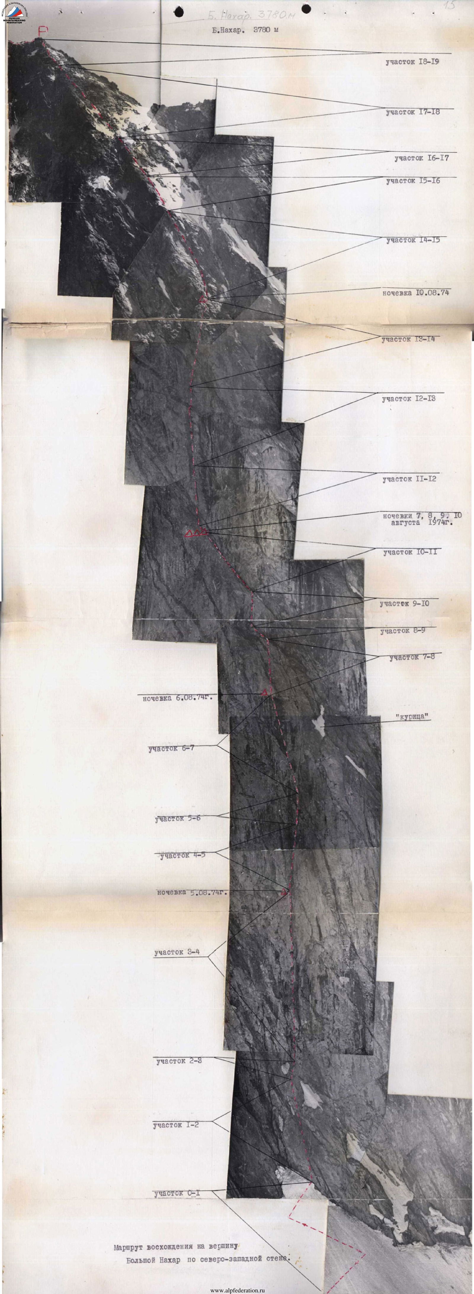
Route of ascent to the summit Bolshoy Nakhara via the north-western wall.