Ascent Passport
- Ascent category: rock
- Ascent area: recreation centre "Uzunkol"
- Ascent route indicating peaks, their altitudes, route complexity (and other approximate details): — peak Kirpich, 3744 m above sea level, 6B, via the North-Northeast wall.
- Ascent characteristics: — Route length (wall): 1080 m — Height difference (wall): 850 m — Average steepness (wall): 78° — Length of difficult sections: — 5: 320 m — 6: 350 m
- Pitons driven: — Rock: 194 — Ice: 0 — Bolt: 9
- Number of climbing hours: 47 h
- Number of climbing days: 6 (including processing)
- Number of bivouacs and their characteristics: 4 bivouacs on good platforms under overhangs, with snow or water available
- Team name: Central Council of the "Trud" Voluntary Sports Society
- Full names of team leaders and participants, and their qualifications: SHAROV Oleg Yakovlevich — Master of Sports — team captain BORZOV Yuri Vyacheslavovich — Master of Sports STATSKY Leonid Nikolayevich — Master of Sports OVSYANNIKOV Yuri Nikolayevich — Candidate for Master of Sports
- Team coach: BENKIN Vladimir Samuilovich — Master of Sports
- Date of departure and return: July 17–22, 1978
On April 16, 1978, at 12:00, the combined team of the Central Council of the "Trud" Voluntary Sports Society, consisting of: — SHAROV O.Ya. — Master of Sports — team captain — BORZOV Yu.V. — Master of Sports — STATSKY L.N. — Master of Sports — OVSYANNIKOV Yu.N. — Candidate for Master of Sports — BENKIN V.M. — Master of Sports — team coach and observer left the recreation centre "Uzunkol" with the task of establishing a storm camp on the moraine in front of peak Kirpich and conducting a final observation of possible rockfall areas in the evening.
July 17. According to the tactical plan, this day was allocated for route processing. The start of the route is in the right part of the rock with two clearly visible cracks, located in the lower right part along the bergschrund, above which there is a wall with black streaks and a stream falling from above. Point 0 of the route is located in a rappel anchor on a narrow rock shelf, which was reached via an ice bridge. From the shelf (section R0–R1), the movement starts up and to the left along a slab; after 20 m, you reach a talus shelf. The slab's steepness is 70°, 3 rock pitons were driven. From the shelf, moving straight up the wall, which is dissected by vaguely expressed angles, you reach a wide internal angle (R1–R2). The length of this section is 40 m, steepness is 70°, 7 rock pitons were driven. Moving along the internal angle (R2–R3), which sometimes turns into a chimney with stoppers and cornices, after 50 m, you reach the 1st control cairn, located slightly below and to the left of a large through crack on the right, forward-facing side of this angle. The steepness of the section is 75°, 8 rock pitons were driven. Moving further along a narrow chimney (R3–R4) with three stoppers, significantly hindering climbing, after 60 m, you hit a kind of trap, shaped like a triangular roof, as if covering the ascent path. The rocks are wet from water flowing from above. You exit from under this undercut to the left and up along a 70° smooth slab and the wall above it (R4–R5), and after 20 m, you reach a small shelf under a small cornice. 4 rock pitons were driven. The cornice is bypassed on the left with an exit to the wall, and after 40 m, you reach a talus shelf (R5–R6). Steepness is 55°, 4 rock pitons were driven. The total processing time was 7 hours. 230 m were covered, of which about 100 m were category 6 complexity. On this day, the entire group worked on the route, with OVSYANNIKOV Yu.N. and STATSKY L.N. working first in turn.
July 18. Leaving the storm camp at 6:30, the group reached the processed part of the route by 11:00 and, continuing to move along simple rocks like "sheep's foreheads" (R6–R7), reached the planned bivouac after 80 m. The steepness of this section is about 60°, 7 rock pitons were driven. The bivouac is protected from rocks by an overhanging wall. The platform for the tent was prepared in 2 hours. While the pair OVSYANNIKOV Yu.N. and STATSKY L.N. were engaged in construction work, the pair SHAROV O.Ya. and BORZOV Yu.V. began further route processing. From the bivouac, the movement was carried out to the right of a black wide couloir with water streams, up and to the left (R7–R8) under a cornice. The length of the section is about 60 m, steepness is 60°, 7 rock pitons were driven. The cornice is passed in the lower right part with an exit to a wall with a steepness of 70°. Along the wall, the movement is straight up for 40 m, and an exit to a shelf (R8–R9) is made; 8 rock pitons were driven. From the shelf, along rocks with a steepness of 50°, representing a system of blocks and inclined slabs, you move straight up to a tower located in the right corner of a large snow patch. The length of the section is about 90 m, 12 rock pitons were driven (R9–R10). The tower is 40 m (R10–R11) and is passed head-on. At the top of the tower, there is a 4 m negative wall; the tower's steepness is 75°, 7 rock pitons were driven. Having reached this point, the pair descended to the bivouac. In total, on this day, 310 m were covered (including the previously processed section), and 230 m were processed, of which 100 m were category 5 and 40 m were category 6.
July 19. At 6:30, the pair BORZOV Yu.V. and STATSKY L.N. began moving along the pre-fixed ropes. Having passed them and moving along rocks ("sheep's foreheads"), after 40 m, they reached under a bastion (R11–R12). The bastion is passed in the right part along a vaguely expressed couloir and leads to the right side of the "Raketka" snow patch (R12–R13). Steepness is 70°, length is 110 m, 18 rock pitons were driven. A traverse to the left and up above the snow patch for 80 m (R13–R14) along a shelf with a steepness of 45°, 9 rock pitons were driven. This was where the second bivouac was planned.
July 20. From the bivouac (R14–R15), the movement is straight up: — initially 8 m along a sheer wall to a small shelf; — from the shelf starts a system of sheer blocks, ending after 16 m with a small overhang, very unpleasant to pass through, as the blocks it's composed of are inclined against the direction of movement. Then follows a sheer wall with a small number of cracks, which is limited on the right side by a somewhat protruding smooth wall. Its length is about 30 m. At the top, the wall somewhat overhangs, but from its upper edge, a clearly visible 4–5 m flake descends, allowing the overhang to be passed by climbing. After passing the wall, you reach a wide talus shelf; its left part is closed by a 6–8 m "feather" that has separated from the main wall. The distance from the bivouac to the shelf is 70 m, 22 rock pitons were driven. To the right, 5 m from it, a crack begins, going up along the overhanging wall of the upper bastion. The difficulty lies in organizing protection due to the small number of cracks; 3 bolt pitons had to be driven for protection. After 50 m, you reach a clearly distinguishable yellow patch (R15–R16). From it, the movement is to the left and up (R16–R17) along a steep inclined slab under an overhanging wall. Here is the second control cairn. Having passed the overhang head-on, you exit to a tiny shelf, from which a new crack begins, turning into a small chimney with many loose rocks at the top. From the shelf to this point, it's 150 m, 5 rock and 5 bolt pitons were driven. The steepness of the section is 85°. On this day, BORZOV Yu.V., OVSYANNIKOV Yu.N., and SHAROV O.Ya. worked as the lead climber in turn. On the same day, we moved the bivouac 70 m higher and somewhat to the side, as, moving vertically from the bivouac during route processing, we were dropping rocks directly into the tent area.
July 21. Having passed the previously processed section and the subsequent chimney, you hit an overhang, which is passed on the right (R17–R18) with an exit to the wall. After that, again, the movement is along a vertical crack with three overhanging sections. After 30 m, the crack leads to a long, strongly inclined shelf. Directly from the exit point, an internal sheer angle with a series of overhangs begins. Further, the route exits to a wall representing a cascading series of overhanging cornices with a very small number of cracks, very complex and psychologically challenging climbing (R18–R19). The route, after 45 m, leads to a large flake with a pile of loose rocks, which is covered from above by a large cornice and is bounded by a sheer smooth wall. The cornice is passed head-on and leads to a smooth, very steep slab, which is also covered by the next overhang. This place is passed in the leftmost part using the left wall. Characteristics of the section: — Length: 50 m — Steepness: 90° — 32 rock pitons, 4 bolt pitons were driven. Having passed the wall, you reach 50° "sheep's foreheads"; after moving along them for 40 m, the rope was fixed. On this day, BORZOV Yu.V., OVSYANNIKOV Yu.N., and again BORZOV Yu.V. worked as the lead climber in turn.
July 22. Having passed the processed section of the route and 40 m of a 50° couloir (R20–R21), we reached the ridge of category 1 difficulty and, after 30 minutes, reached the summit. The height difference from the point of exit to the ridge to the summit is about 100–120 m.
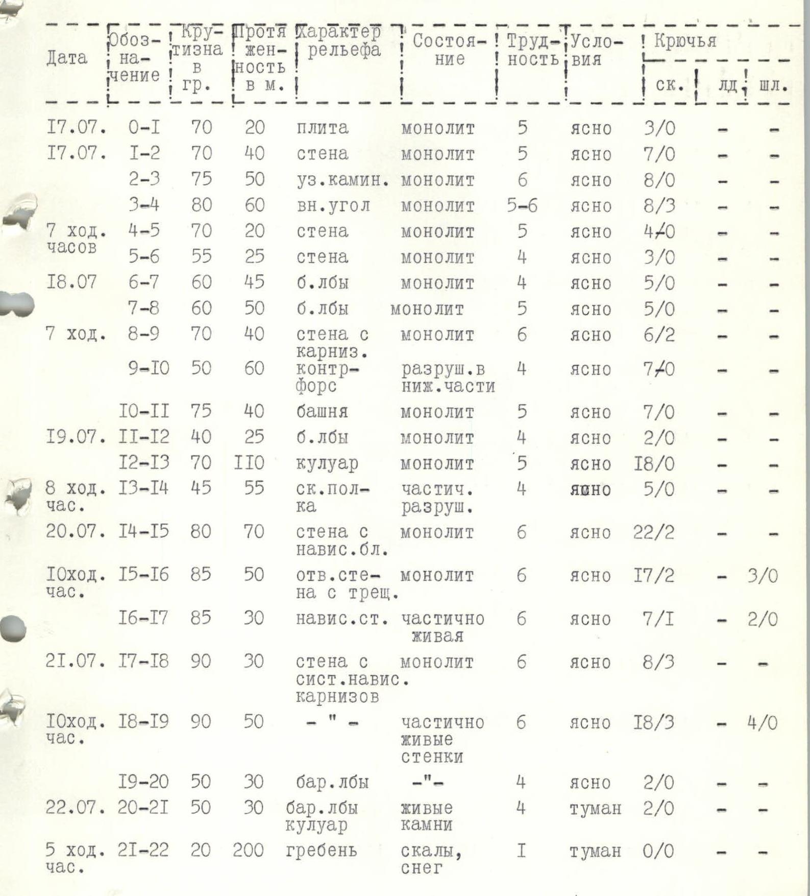
Table of Main Route Characteristics
| Designation | Steepness | Length, m | Relief Character | Condition | Difficulty | Conditions | Pitons (rock, ice, bolt) |
|---|---|---|---|---|---|---|---|
| 17.07. R0–R1 | 70° | 20 | slab | monolithic | 5 | clear | 3/0 |
| 17.07. R1–R2 | 70° | 40 | wall | monolithic | 5 | clear | 7/0 |
| R2–R3 | 75° | 50 | narrow chimney | monolithic | 6 | clear | 8/0 |
| R3–R4 | 80° | 60 | internal angle | monolithic | 5–6 | clear | 8/3 |
| 7 climbing hours | R4–R5 | 70° | 20 | wall | monolithic | 5 | clear |
| R5–R6 | 55° | 25 | wall | monolithic | 4 | clear | |
| 18.07. R6–R7 | 60° | 45 | sheep's foreheads | monolithic | 4 | clear | 5/0 |
| R7–R8 | 60° | 50 | sheep's foreheads | monolithic | 5 | clear | |
| 7 climbing hours | R8–R9 | 70° | 40 | wall with cornice | monolithic | 6 | clear |
| R9–R10 | 50° | 60 | buttress | partially destroyed | 4 | clear | |
| R10–R11 | 75° | 40 | tower | monolithic | 5 | clear | |
| 19.07. R11–R12 | 40° | 25 | sheep's foreheads | monolithic | 4 | clear | 2/0 |
| R12–R13 | 70° | 110 | couloir | monolithic | 5 | clear | |
| 8 climbing hours | R13–R14 | 45° | 55 | rock shelf | partially destroyed | 4 | clear |
| 20.07. R14–R15 | 80° | 70 | wall with overhanging blocks | monolithic | 6 | clear | 22/2 |
| 10 climbing hours | R15–R16 | 85° | 50 | sheer wall with crack | monolithic | 6 | clear |
| R16–R17 | 85° | 30 | overhanging wall | partially loose | 6 | clear | |
| 21.07. R17–R18 | 90° | 30 | wall with system of overhangs | monolithic | 6 | clear | 8/3 |
| 10 climbing hours | R18–R19 | 90° | 50 | – | partially loose walls | 6 | clear |
| R19–R20 | 50° | 30 | sheep's foreheads | – | 4 | clear | |
| 22.07. R20–R21 | 50° | 30 | sheep's foreheads, couloir | loose rocks | 4 | fog | 2/0 |
| 5 climbing hours | R21–R22 | 20° | 200 | ridge | rocks, snow | 1 | fog |
Summit reached at 11:45.
Reaching the Summit
Summit reached at 11:45.

Additional Route Characteristics
- Relative wall height 850 m. Ridge — category 1 difficulty. Couloir (partially loose rocks) — category 4 difficulty. Sheep's foreheads (partially loose rocks) — category 4 difficulty.
- July 11, 1900. Relative height 750 m. Wall with a system of 12 overhanging cornices — category 6 difficulty.
- Wall with a system of overhanging cornices — category 6 difficulty.
- Overhanging wall (loose rocks) — category 6 difficulty.
- July 15. Relative height 630 m. Sheer wall with crack (monolithic) — category 6 difficulty.
- July 19. Relative height 565 m. Wall with overhanging blocks (monolithic) — category 6 difficulty.
- Rock shelf (partially destroyed) — category 4 difficulty.
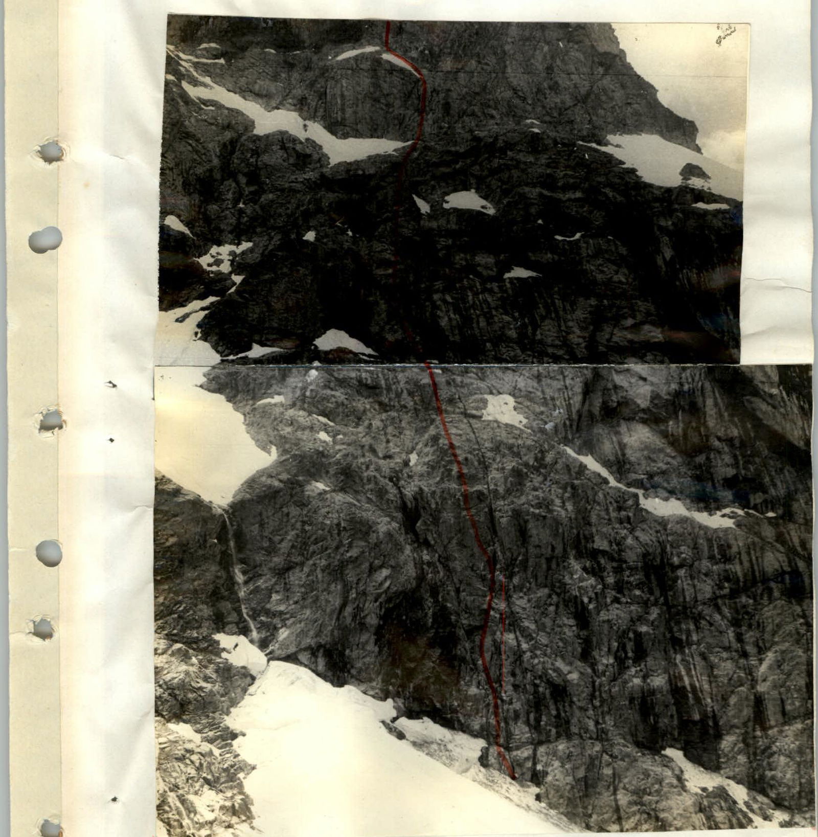
Lower and Middle Part of the Route
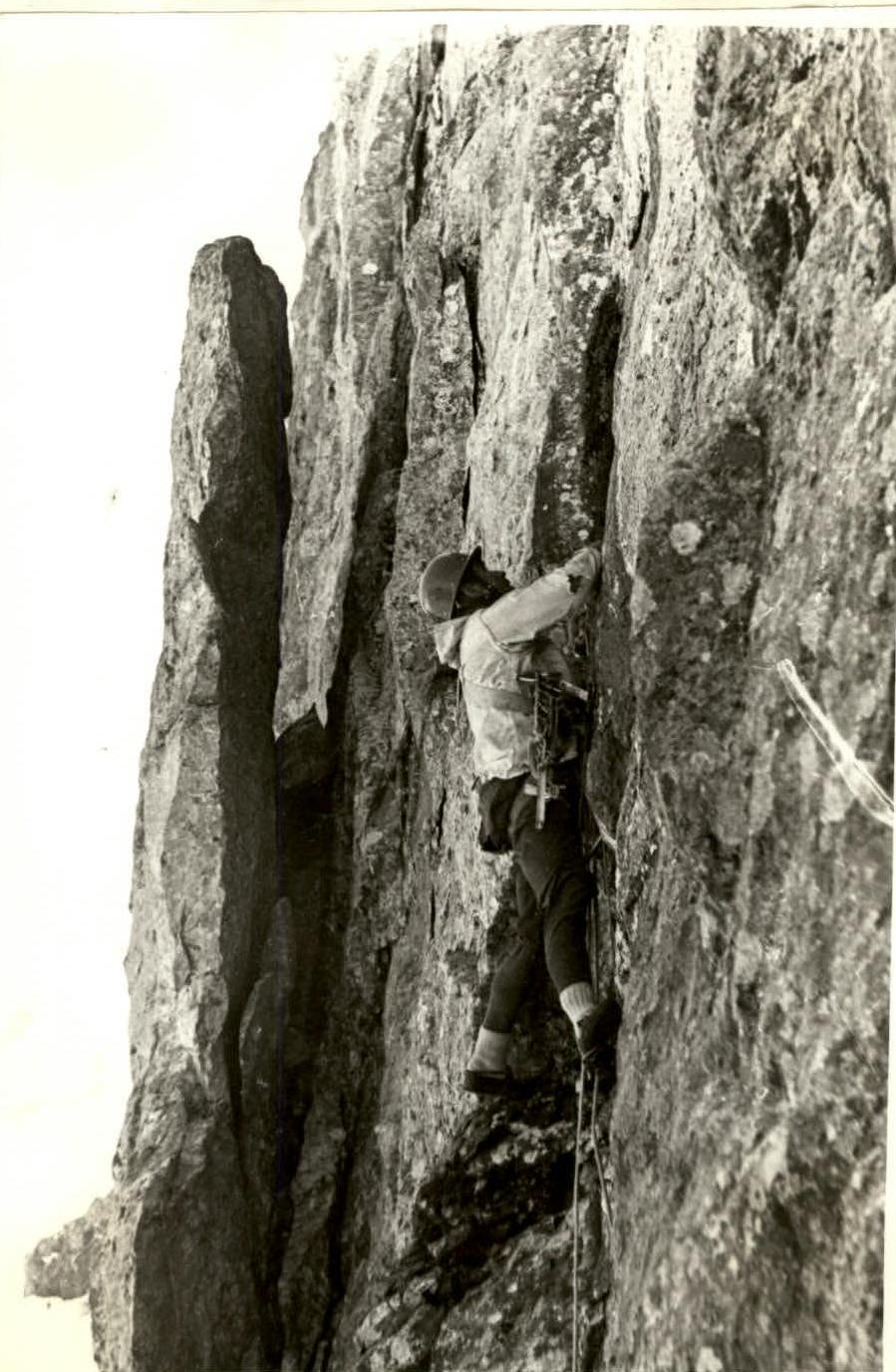
Passage of Section R15–R16
Passage by Yu. Borzov of section (R15–R16)
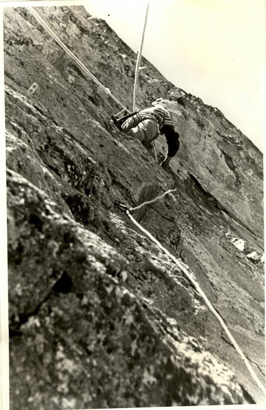
Belay Point on Section R15–R16
Belay by OVSYANNIKOV Yu. of BORZOV Yu. on section (R15–R16)
 www.alpfederation.ru↗