Ascent Passport
- Ascent category — technical.
- Ascent area — Main Caucasus Range from Nakhar Pass to Chipperazau Pass.
- Ascent route — Kirpich Peak (3300 m) via the North face.
- Ascent characteristics: height difference — 1050 (face — 700), average steepness — 47° (face — 67°), length of complex section — 160 m + 120 m.
- Pitons hammered: rock — 226, ice — none, bolt pitons — none.
- Total climbing hours — 39.
- Number of bivouacs — 3 (2 on the face): on ledges, in tents, snow present.
- Team name — Team of Leningrad Regional Council of DSO "Zenit".
- Team members: Ivan Yakovlevich Shestipalov — Master of Sports, leader; Boris Vasilyevich Gladkikh — Candidate for Master of Sports, Eduard Andreyevich Oshe — Candidate for Master of Sports, Vladimir Ivanovich Popov — Candidate for Master of Sports.
- Team coach — Ivan Yakovlevich Shestipalov.
- Date of departure for the route — August 4, 1974, date of return — August 7, 1974.

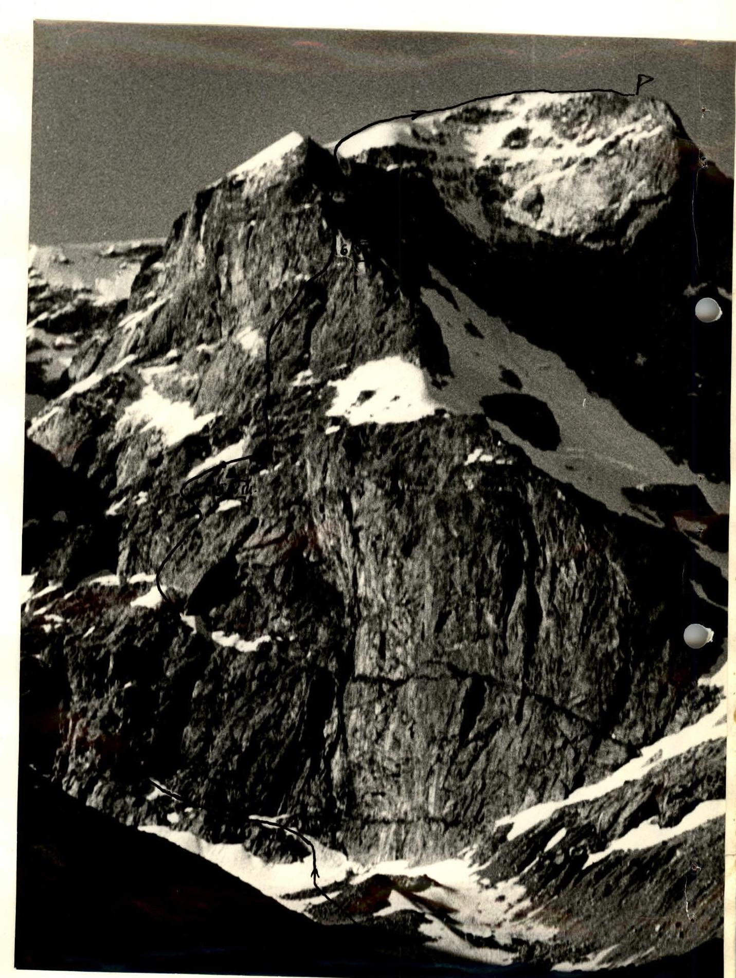
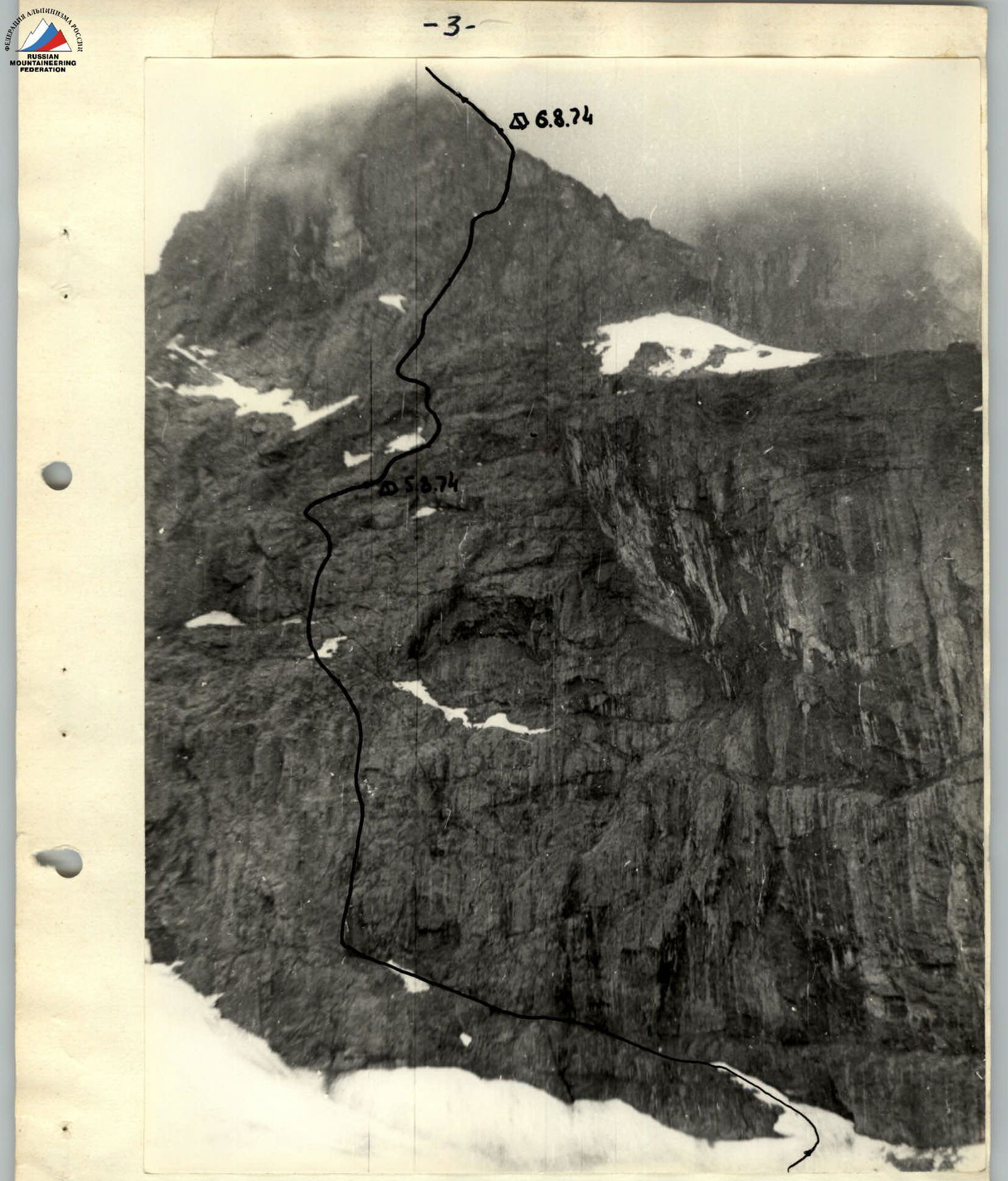
Photo 2. Kirpich Peak. North face.
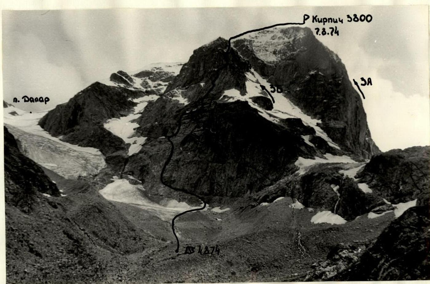
Photo 5. Section R0–R1. Approach to the face.

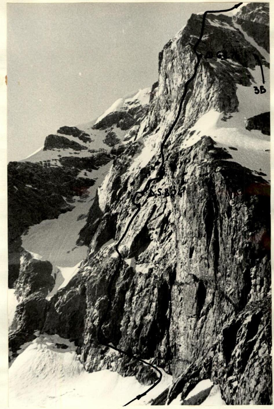
Photo 6. Profile photograph of the route.
Table of main characteristics of the ascent route
Ascent route — Kirpich Peak (3800 m) via the North face.
| Date | Sections completed | Average steepness of section | Length of section (by length), m | Characteristics of section and passage conditions | | | | Time of bivouac stop, departure, climbing hours | Pitons hammered | | | Bivouac conditions | Remarks | | :------------------ | :---------------------- | :----------------------- | :---------------------------------- | :------------------------------------------- | :-------------- | :--------------------------------------- | :--------------------------- | :--------------------------------------------------------------------------------------------------------------------------------------------------------------------------------------------------- | :--------------- | :------- | :------------- | :-------------------------------------------------------------------------------------------------------------------------------------------------------------------------------------------------------------------------------------------------------------------------------------------------------------------------------- | | | | | | by terrain character | difficulty category of section | by passage method and skill | by weather conditions | | rock | ice | bolt pitons | | | | August 4, 1974 1st day | Processing route sections R0–R9 | | | | | | | 20:00 13:30 6:30 | | | | good, moraine at the wall | | | August 5, 1974 2nd day | R0–R1 | 10° traverse | 160 | Rock ledge with snow and water | 1 | simultaneous | good | 19:30 4:00 15:30 | | | | | Approach from bivouac to ledge under the wall via moraine, glacier, and snow took 30 min. First control tour at the end of the ledge. | | | R1–R2 | 70–80° | 15 | wall | 3 | free climbing, pitons | -«- | | 4 | | | | Section of the wall visible in photo 9, with an inner corner visible at the top. Under the black cornice, traverse right. | | | R2–R3 | 85–90° | 5 | inner corner | 4 | free climbing, pitons | -«- | | 3 | | | | | | | R3–R4 | 45° traverse | 5 | ledge under cornice | 4 | free climbing, pitons | | | 3 | | | | | | | R4–R5 | 85–90° | 15 m | wall with few holds | 5 | free climbing, ladders, pitons, rope pulling | | | 9 | | | | Two options to pass the wall: straight up (more difficult), or traverse right from the top part (more dangerous due to earth on the ledge). Photo 10. | | | R5–R6 | 45–50° | 15° | 15 | rocks like "ram's foreheads" | 3 | free climbing, pitons | | | 3 | | | | | | 1 | 2 | 3 | 4 | 5 | 6 | 7 | 8 | 9 | 10 | 11 | 12 | 13 | 14 | | | R6–R7 | 80–90° | 25 | gray wall behind very wet inner corner | 4 | free climbing, ladders, pitons, rope pulling | | | 11 | | | | | | | R7–R8 | 60° | 20 | several small walls 2–3 m | 2 | free climbing | | | 2 | | | | | | | R8–R9 | 35–40° | 60 | talus ledge | 1 | simultaneous, insurance to outcrops | | | | | | | | | | R9–R10 | 80–85° | 20 | wall on the right side of inner corner | 5 | free climbing, pitons, rope pulling | | | 10 | | | | Photo 11 | | | R10–R11 | 45° | 10 | inclined ledge | 1 | simultaneous | | | | | | | | | | R11–R12 | 80–85° | 30 | wall | 4 | free climbing, pitons, first rope pulling | | | 16 | | | | Photo 12 shows exit from the wall | | | R12–R13 | 30–40° traverse | 80 | ledge along black vein | 2 | free climbing | | | 6 | | | | Photo 13. Black vein leads to a ledge where a bivouac can be organized. Water can be obtained from the snowfield with a rope. | | | R13–R14 | 60–70° | 80 | rocks like "ram's foreheads", "ladder" rocks | 2 | free climbing | | | 6 | | | | Photo 16 shows the moment of gathering all ascent participants. Water obtained from the snowfield. Photos 14, 15. | | | R14–R15 | 30° traverse | 50 | inclined wet slab under cornice | 2 | free climbing | | | 5 | | | | Caution! Wet! Mud! Photo 17 shows reconnaissance of traverse to the right (ledge ends in a wall with cornices). Photo 18 too, after removing ropes. | | 1 | 2 | 3 | 4 | 5 | 6 | 7 | 8 | 9 | 10 | 11 | 12 | 13 | 14 | | | R15–R16 | 85–90° | 25 | inner corner leading to cornice | 5 | free climbing, ladders, pitons, rope pulling | | | 12 | | | | Photo 19 | | | R16–R17 | 60° traverse | 8 | wall under cornice | 5 | -«- | | | 5 | | | | Photo 20 | | | R17–R18 | 70° | 20 | destroyed red rocks | 3 | free climbing | | | 3 | | | | Caution! Many loose stones. Photo 21 shows the moment of exiting onto red rocks. | | | R18–R19 | 30° | 80 | destroyed ridge leading to wide talus ledge with snow | 2 | free climbing | | | 4 | | | Bivouac under a large stone near a snowfield. Necessary to have insurance. Safe. Average conditions, snow present. | | | August 6, 1974 3rd day | R19–R20 | 30° traverse | 100 | ledge | 2 | free climbing | good | 19:30 5:00 14:30 | 5 | | | | | | | R20–R21 | 70–80° | 6 | wall | 4 | free climbing, ladders, pitons | | | 5 | | | | Wall passed near a detached stone | | | R21–R22 | 60–70° | 40 traverse | smoothed slabs | 4 | free climbing | | | 7 | | | | | | | R22–R23 | 80° | 30 | wall, right side of inner corner | 4 | free climbing | | | 9 | | | | Caution! Loose stones! | | 1 | 2 | 3 | 4 | 5 | 6 | 7 | 8 | 9 | 10 | 11 | 12 | 13 | 14 | | | R23–R24 | 70° | 70 | destroyed rocks with separate walls | 3 | free climbing | | | 12 | | | | Direction to red inner corner, another variant visible straight up to section R30–R31 | | | R24–R25 | 30° traverse | 89 | narrow ledge | 2 | free climbing | | | 4 | | | | To rocks with a detached stone | | | R25–R26 | 85–90° | 15 | wall with cornice | 4 | free climbing | | | 5 | | | | | | | R26–R27 | 75–80° | 10 | inner corner | 2 | free climbing | | | 2 | | | | | | | R27–R28 | 40–50° | 25 | rocks like "ram's foreheads" | 2 | free climbing | | | 3 | | | | | | | R28–R29 | 75–85° | 80 | wall, initially not clearly expressed inner corner | 4 | free climbing (first without backpack) | | | 14 | | | | Possible variant: traverse left through talus couloir to ledge and then up wall with cornice to visible ledge leading to section R30–R31 or exit to eastern part of north face. After 60 m traverse, possible ascent straight up the wall, but requires significant bolt work (wall 95–100°). Photo 8. | | | R29–R30 | 70° | 40 | chimney | 4 | free climbing | | | 6 | | | | Direction to inner corner at light-colored crack | | | R30–R31 | 70° traverse | 30 | wall | 4 | free climbing, first without backpack | | | 6 | | | | Caution! | | | R31–R32 | 70–80° | 40 | wall with small mossy ledges | 5 | free climbing, rope pulling | | | 10 | | | | | | 1 | 2 | 3 | 4 | 5 | 6 | 7 | 8 | 9 | 10 | 11 | 12 | 13 | 14 | | | R32–R33 | 85–90° | 30 | crack | 5 | free climbing, ladders | | | | | | | | | | R33–R34 | 100° | 5 | cornice | 5 | rope pulling | | | 29 | | | | No place for whole group to gather | | | R34–R35 | 80° | 8 | wall | 5 | | | | | | | | | | | R35–R36 | 10° | 30 | ledge | 1 | simultaneous | | | | | | Bivouac on ledge, snow present, safe | Organization of bivouac | | August 7, 1974 4th day | R36–R37 | 45° | 30 | ridge | 1 | simultaneous | good | 9:45 7:00 2:45 | | | | | | | | R37–R38 | 70° | 7 | wall with moss | 3 | free climbing (first with rope pulling) | | | 4 | | | | | | | R38–R39 | 45° | 25 | ridge | 2 | free climbing | | | 1 | | | | | | | R39–R40 | 20° | 5 | wall | 3 | free climbing | | | 3 | | | | | | | R40–R41 | 30–40° | | destroyed rocks with snowfields, leading to snowy pre-summit ridge | 1 | simultaneous | | | | | | | Upper part of route 3B category. Descent via route 1B category. |
Team Captain: Shestipalov Team Coach: Shestipalov
Tactical Ascent Plan
Given the anticipated high complexity of the upper and lower parts of the route, the following tactical ascent plan was developed.
- First day — departure from camp, approach to the wall, and processing of the lower part of the route.
- After that, the group was to exit onto the wall and, considering unstable weather, pass it with a minimal number of bivouacs, ideally four.
This tactical plan was largely executed. The route was completed with two bivouacs on the wall. The ascent was carried out in good weather.
The group was to maintain radio contact with groups at a/l "Uzunkol", located at "Myrdy" bivouac and nearby areas.
Description of Route Passage
The team departed from a/l "Uzunkol" on August 4, 1974, at 10:00. The approach through Myrdy Valley to the bivouac under the north face of Kirpich Peak took 2 hours 30 minutes. At 13:30, the rope team Shestipalov — Oshe began processing the wall. 120 m of rope were fixed. The team returned to the bivouac under the wall at 20:00. On the 2nd day, August 5, 1974, the team started the ascent at 4:00.
Section R0–R1
Traverse left along the ledge (160 m) to the wall with a control tour. Movement without rope teams (Photos 1–3).
Section R1–R2
Complex rock wall. Ascent in the direction of a clearly expressed inner corner. (Photo 9).
Section R2–R3
Inner corner leading to the base of the cornice. Climbing is very difficult.
Section R3–R4
Traverse of a steep ledge under the cornice. The section is psychological due to the abyss below. The ledge has areas with earth.
Section R4–R5
One of the most complex sections of the route. The wall is almost vertical. Climbing is extremely difficult with the use of ladders. Two options to overcome the wall:
- straight up (more complex);
- traverse right from the top part (more dangerous).
Section R5–R6
Rocks like "ram's foreheads". Difficult climbing (right and up) towards a wet inner corner (Caution! Rocks are wet).
Section R6–R7
Gray wall behind the wet inner corner. Overall steepness 80–90°. Climbing is very difficult through a crack. Loose stones present. Ladders, rope pulling.
Section R7–R8
Several small walls (2–3 m) towards a large talus ledge.
Section R8–R9
Gentle talus ledge with loose stones. Insurance can be done using outcrops on the right part of the ledge.
Section R9–R10
Ledge leads to a wall. Climbing is extremely difficult. Start on the left side of the inner corner, then move to the right side. Ladders, rope pulling. (Caution! Loose stones). Photo 11.
Section R10–R11
Wall ends in an inclined ledge (45°). Climbing is simple, simultaneous.
Section R11–R12
Steep 30-meter wall. Climbing is very difficult. Ladders, pitons. First climber's backpack is pulled up. Wall ends in a ledge with a black vein (Photo 12).
Section R12–R13
Traverse left along the ledge with a black vein. Bivouac possible at the end of the ledge. Water can be obtained from a snowfield with a rope (Photo 13).
Section R13–R14
Rocks like "ram's foreheads" and "ladders". Few places to hammer pitons. Snowfields present where water can be obtained (Photos 14, 15, 16).
Section R14–R15
Rocks lead to a 3-meter wall and an inclined slab under a cornice. Traverse right is possible but reconnaissance showed that the ledge ends in a wall with cornices, making further passage problematic. Traverse left (Caution! Wet! Mud!) to a large inner corner (Photos 17, 18).
Section R15–R16
Inner corner (almost vertical) leads to a cornice with water dripping from it. Climbing is extremely difficult. Ladders. Rope pulling (Photo 19).
Section R16–R17
Traverse of a steep wall under a cornice. Climbing is extremely difficult. Wall is wet and muddy. Exit onto a ledge under a wall with red rocks (Photo 20).
Section R17–R18
Passage of destroyed red rocks — left to right and up. Few places to hammer pitons. Caution! Many loose stones! Possible variants: straight up or small traverse right to left. Both seem more complex (Photo 21).
Section R18–R19
Destroyed ridge and onto a talus ledge under a snowfield. Bivouac under a large stone. Safe from falling stones but requires insurance due to steep slope.
Section R19–R20
100-meter traverse right along a narrow ledge with minimal height gain.
Section R20–R21
6-meter wall with few holds passed with a ladder on the left side of a detached stone.
Section R21–R22
40-meter traverse left along smoothed slabs to an inner corner. Very difficult. Pitons.
Section R22–R23
Ascent up an 80° inner corner on the right side to destroyed rocks. Caution! Loose stones! Climbing is very difficult.
Section R23–R24
Passage of destroyed rocks with separate walls towards a visible light-colored crack below the ridge. Alternative exit to section R30–R31 possible (Photo 8).
Section R24–R25
80-meter traverse left along a narrow ledge to a wall with a cornice.
Section R25–R26
Monolithic wall with a small cornice passed straight up. Climbing is very difficult. Few places to hammer pitons.
Section R26–R27
Inner corner passed in two parts: first 4 m on the left, then on the right.
Section R27–R28
Exit from the inner corner onto rocks like "ram's foreheads". Climbing is done right to left and up to a detached stone. Many loose stones.
Section R28–R29
Ascent up a wall with an initially not clearly expressed inner corner. Few places to hammer pitons. Direction is towards the same light-colored crack below the ridge. Alternative variants:
- Traverse left through a talus couloir and "ram's foreheads" to a ledge near a snowfield, then to the eastern edge of the north face (route not visible) (Photo 8);
- From the snowfield straight up — requires significant bolt work due to wall steepness (95–100°) (Photo 8);
- From the ledge, exit right and up onto a wall with a cornice and a visible ledge leading to section R30–R31 (Photo 8).
Section R29–R30
40-meter chimney. Climbing is very difficult. Leads to a talus ledge where a tent can be set up.
Section R30–R31
30-meter traverse right. Climbing is very difficult due to moss on steep rocks. First climber goes without a backpack.
Section R31–R32
Steep wall with small mossy ledges. Climbing is extremely difficult. Pitons. Rope pulling.
Section R32–R33
Wall leads to a vertical crack. Climbing is extremely difficult. Ladders, wedges. Psychological section.
Section R33–R34
Crack ends in a cornice with a stuck stone. Climbing is extremely difficult. Requires technique and significant effort. Wedges. Psychological section.
Section R34–R35
Traverse left under a detached stone and exit onto a wall. Climbing is done left to right. Requires bolt pitons for reliable insurance.
Section R35–R36
Wall leads to a ridge. Bivouac organized at 19:30.
Section R36–R37
4th day of ascent. Departure at 7:00. 30 m ascent in the direction of the wall on the ridge (right to left) — simple climbing.
Section R37–R38
70° wall with a cornice on the left. Moss present. First climber without a backpack. Alternative variant: passage through the right inner corner.
Section R38–R39
Gentle ridge. Climbing is done left to right towards a small wall (upper part of route 3B category).
Section R39–R40
Wall is complex but has sufficient holds.
Section R40–R41
Ascent via destroyed rocks left of route 3B category onto a snowy ridge and then to the summit. Descent via route 1B category through Dalar Pass.
Characteristics of Team Members' Actions (Team Leader Shestipalov)
This ascent was a serious test of the technical and physical preparedness of all team members. The presence of skilled rock climbers and the excellent physical and technical preparation of all participants allowed the team to complete the route in a minimal amount of time.