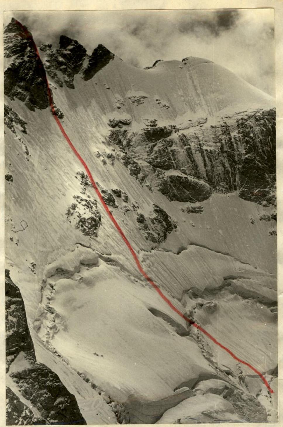
Ascent to the summit Zamok 3981 m via the northwestern ice-snow wall, approximately 5A category of difficulty.
The first passage of the specified route was made in 1977 by a team from the "Uzunkol" camp, consisting of:
- Korablin B.N. - Master of Sports of the USSR - leader
- Oshche E.A. - Candidate Master of Sports
- Rybakov M.I. - Candidate Master of Sports
- Popov V.I. - Candidate Master of Sports
Ascent Passport
-
Ascent class - ice-snow
-
Ascent area - Western Caucasus, Gvandra region
-
Peak, route - Zamok 3871 m via the center of the NW wall, approximately 5A category of difficulty
-
Route characteristics:
- Height difference from the Bolshoy Kichkinokol glacier - 1000 m;
- Length of sections with 5th category of difficulty;
- Ice and snow in the lower part, rock tower - 830 m;
- Average steepness of ice and snow sections - up to 50°;
- Average steepness of the tower - rock - 75°.
- Pitons used: rock - 38, including 1 for ITO; ice - 100, including 1 for ITO.
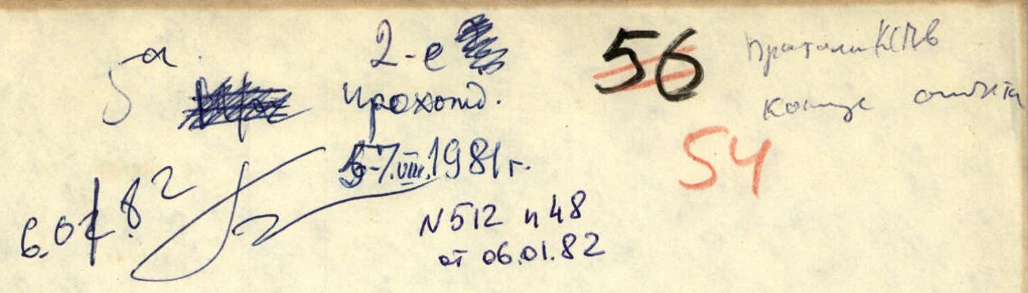
- Number of climbing days - three
- Number of climbing hours - 26
- Number of overnight stays and their characteristics - on a ledge at the base of the tower - semi-sitting; on the Burvestnik pass - platform. Possible overnight stays: on the rocks of rocky islands - under overhangs - in the middle part of the ice wall, on the entire descent route via the 4A category route.
- Team name - group of climbers from the "Uzunkol" alpine camp.
- Full name of the leader, participants, and their qualification: Rybyn M.V. - 1st sports category, Shchepanovsky V.Yu. - 2nd sports category.
- Group coach - Zakharov P.P.
- Date of departure and return - August 5-7, 1981.
Route:
- From the "Uzunkol" alpine camp, along the left bank of the Kichkinokol river to the sheepfold
- Further along the moraines and talus to the tongue of the Bolshoy Kichkinokol glacier
- At the end of the left bank moraine - bivouac site. From the camp - 2.5 hours.
From the bivouac, across the talus and moraines, exit to the glacier plateau. Then ascend the snow slopes towards the bifurcated rocky island, then along the firn slope towards the summit tower to the fractures in the glacier. Crevasses are traversed via bridges with subsequent overcoming of individual walls with steepness up to 65-85°.
Having passed the fractures, ascend to the large gap located at the level of the upper rocks below the Filtr peak. From the bivouac to this location, approximately 6-7 hours.
The large gap is traversed under the slopes of the northern buttress of Zamok - CAUTION! - this section should be traversed before 9:00 AM - FALLING ICE BLOCKS! Do not press against individual narrow ice break-offs - they are in an unstable equilibrium!
Further, the path leads to the middle of the large bergschrund with a firn break-off in its middle part. The bergschrund is overcome via the break-off with subsequent digging through the firn layer at its upper edge.
From here, 12 rope lengths of work on the ice slopes to the summit tower. A narrow bergschrund under the rocks protruding from the ice is traversed via the rocks or avalanche cones (if they completely overlap the bergschrund). Under individual overhangs of rocks, bivouac organization is possible.
Exit to the summit tower left of the characteristic gray wall via a faintly expressed ledge left-upwards to a steep talus ledge. Here, at the base of the diverging faintly expressed internal angle and crevice, a platform for a sitting bivouac and a control cairn. From the bivouac on the glacier to here, approximately 15-16 hours of work.
Internal angles, as a rule, are filled with flow ice. Along the left internal angle, under the overhang and exit to a small rib like a buttress, leading to the summit. Very complex and tense climbing with the use of ITO. An alternative exit to the buttress via the right crevice is possible, but it is more heavily iced. Exit to the summit via a short wall and ridge.
Descent from the summit via the 4A category route to the Burvestnik pass and further through the Kichkinokol pass - return to the "Uzunkol" camp.
Table of main characteristics of the ascent route to the Zamok peak via the NW wall
| Date | Designation | Avg. steepness | Length | Relief characteristics | Difficulty | Condition | Weather conditions | Rock pitons | Ice pitons |
|---|---|---|---|---|---|---|---|---|---|
| August 5 | R0–R1 | 25–35° | 300 m | Firn slope | 2 | Crevasses | Good | ||
| R1–R2 | 35–50° | 400 m | Icefall | 4–5 | Falls, crevasses | —"— | 15 | ||
| R2–R3 | 35–40° | 120 m | Firn-ice slope | 3 | Good | —"— | |||
| R3–R4 | 80–95° | 15 m | Ice wall | 5–6 | Individual break-offs | —"— | 8 | ||
| R4–R5 | 40–45° | 120 m | Firn slope | 4 | Good | —"— | 8 | ||
| R5–R6 | 90–100° | 10 m | Bergschrund | 5–6 | Good | Wet snow, fog | 4 | ||
| R6–R7 | 45–50° | 160 m | Ice slope | 5 | Steep gullies | —"— | 20 | ||
| R7–R8 | 100° | 3 m | Bergschrund | 5–6 | —"— | 3 | |||
| R8–R9 | 45–55° | 80 m | Ice slope | 5 | Gullies | —"— | 10 | ||
| R9–R10 | 50° | 40 m | Rocks like sheep's foreheads | 4 | Flow ice | Normal | 6 | 2 | |
| R10–R11 | 50–60° | 240 m | Ice slope | 5 | Gullies | — | 30 | ||
| August 6 | R11–R12 | 80° | 15 m | Rocks like sheep's foreheads | 5 | Flow ice | —"— | 3 | 1 |
| R12–R13 | 95° | 10 m | Rock wall | 6 | Flow ice | —"— | 4 | ||
| R13–R14 | 75° | 15 m | Rock ledge | 4 | Flow ice | —"— | 2 | ||
| R14–R15 | 45° | 40 m | Rock ledge | 3 | Flow ice | —"— | 1 | ||
| R15–R16 | 45° | 10 m | Rock ledge | 3 | Flow ice | —"— | 1 | ||
| R16–R17 | 90° | 15 m | Internal angle | 5 | Flow ice | —"— | 3 | ||
| R17–R18 | 85° | 5 m | Wall | 5 | Flow ice | —"— | 1 | ||
| R18–R19 | 95° | 7 m | Wall | 6 | Flow ice | —"— | 2 | ||
| R19–R20 | 100° | 5 m | Cornice | 6 | Normal | Normal | 2 | ||
| R20–R21 | 45° | 40 m | Rocks like sheep's foreheads | 4 | Covered with snow | — | 4 | ||
| R21–R22 | 50° | 40 m | System of ledges and walls | 3 | —"— | Fog, wet snow | 4 | ||
| R22–R23 | 70° | 35 m | Internal angle | 4 | —"— | Fog, wet snow | 5 | ||
| R23–R24 | 75° | 30 m | Wall, ridge to the summit | 3 | —"— | Fog, wet snow | 1 | ||
| 1755 m | 38 | 100 |
- Categories of difficulty for ice and snow sections are given in relation to the group's ascent conditions.
Note: On all sections where "gullies" are indicated - do not enter them - possible rockfall from the summit tower and small avalanches - everything flows into the gullies!!!
Group coach
Description of the croquis
Summit tower - see croquis according to UIAA symbology
- R10: 240 m, 5 ice slope
- R9: 40 m, 45-55° 4, sheep's foreheads
- R8: 80 m, 45-50° 5, ice slope
- R7: 3 m, 100° 5-6, bergschrund
- R5: 10 m, 90-100° 5-6, bergschrund
- R6: 160 m, 45-50° 5, ice slope
- R4: 120 m, 40-45° 4, firn slope
- R3: 15 m, 80-95° 5-6, ice fall-wall
- R2: 120 m, 35-40° 2
- Categories of difficulty for ice and snow sections are given in relation to the group's ascent conditions.
- R1: 400 m, 35-50° 4-5, icefall
- R0: 300 m, 25-35° 2, firn slope
Scheme of exit to the summit tower (according to UIAA)
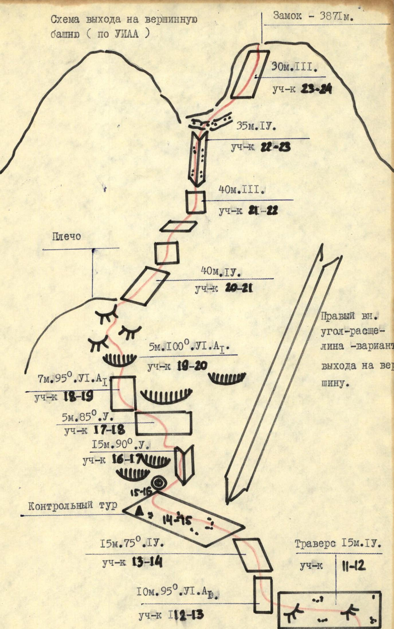
Middle part of the route and exit to sheep's foreheads